 Legendary Dartmoor The many aspects past and present of Dartmoor

High up on the north moor at an altitude of 1,798 feet a small dribble of water issues from the peat at grid reference SX 59367 80473. This small trickle of water will drop down 890 ft over a course of about 4.6 miles before flowing into the West Dart river at an altitude of 1108 ft. On its babbling journey it will pick up 3 major tributaries and 4 feeder streams and is called the river Cowsic.
As always, the best place to start is with the actual name, in this case ‘Cowsic’. It would appear to suggest connections with ailing bovines but in fact the first recorded instance of the name appears in the Duchy of Cornwall records of 1612 when it was written as Cowlsick Coume and again in 1702 when it had mutated to Cowsick (Head), Gover et al, 1992, p.3. The Place-Name Society state the name is too late for any suggested meaning. There is however in Devon a place called Cowick Barton which Ekwall, 1980, p.126, suggests means Cow Wic (Old English – farm, settlement etc., p.515), thus giving ‘Cow Farm’. It could be possible that at one time there was a farm which kept cattle somewhere near to the river thus earning the river the name of Cowswic but if that was the case then it would date the farm to the Saxon times which seems a bit early and dubious.
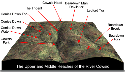
So from its source the first feature the Cowsic meets is a confluence of the main river and two small feeder streams thus forming a three pronged feature, this for obvious reasons has been called ‘The Trident’. This name can be attributed to Eric Hemery as in his High Dartmoor book, p.400, he writes:
“A moorman’s path from Walkham Head crosses the trident waters at Cowsic Head ford and runs via Devil’s tor to the Methern Brook valley.”
The name has now stuck as it has entered letterboxing parlance and several letterboxes titled ‘The Trident’ have been sighted over the years. Immediately up the eastern valley side is the Bronze Age menhir known as ‘Beardown Man‘ and not far away the small outcrop of Devil’s tor. Although the river drops 890ft throughout its 4.6 mile course, 50% or 400ft of that drop occurs in the first 1.4 miles and is between its head and Traveller’s Ford. About ½ a mile from the trident, on the western bank are the remains of a Bronze Age settlement. It would have consisted of a double enclosure which encompassed five huts.
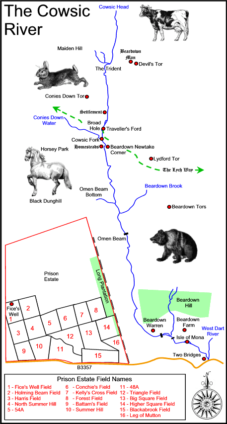
The Course of the River Cowsic
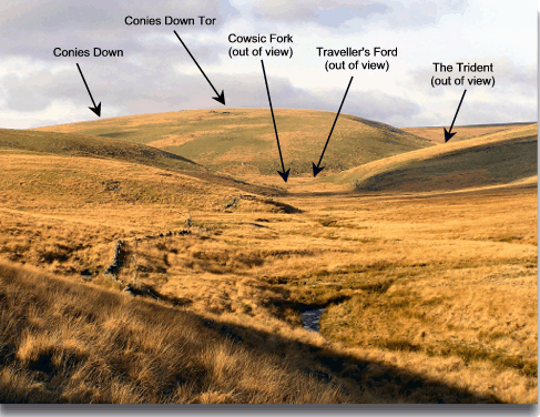
The river then flows on down past Conies Down and Conies Down tor on the western side of the valley, through Broad Hole until it reaches Traveller’s Ford and receives it first main tributary in the form of Conies Down Water. Whenever you come across a place-name on Dartmoor that contains the word ‘hole’ it is usually describing a miniature gorge or narrow valley. Crossing, p.120, notes how during the 1800’s the remains of an oak tree were discovered here, it was said to have been larger than any found at Wistman’s Wood and indicates that at one time there were trees growing in the vicinity. It is here that the first of the three river islands can be seen, and although it is small it still adds immensely to the character of the upland river course. On both sides of Broad Hole are the remnants of two small enclosed homesteads which date to the Bronze Age. Below these on the western bank is another enclosure containing three huts. The ford is where the ancient Lych Way or ‘Way of the Dead’ crosses the Cowsic on its way to Lydford. The junction where both river and tributary meet is known as ‘Cowsic Fork’ and once again is described by Hemery, p.399 in prosaic terms as being:
“… the most satisfying place in the entire valley. There are steep green hills and meeting waters, the crossing of the venerable Lych Way at Traveller’s Ford, the rocky slopes of Conies Down tor, the slight yet sparkling leaps of the river as it descends from its upper reach to Traveller’s Ford, and overall a sense of seclusion from that mechanized modernity which, in one form or another, is all too near.“
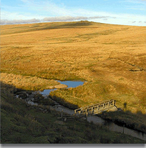
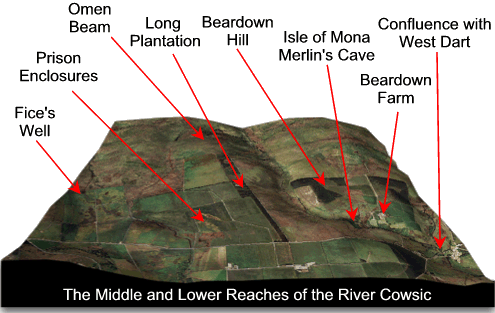
Once the river passes Traveller’s Ford it begins to level out, its course begins a slow meander down towards Omen Beam bottom where the ground becomes very boggy. A small feeder stream joins the river as it flows down from the top of Omen Beam. There are signs here that the old tinners at one time were at work, the heaps of pebbles baring witness to their search for tin.
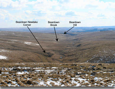
Looking up the Cowsic valley from Omen Beam
Shortly after receiving the feeder stream it then is joined by a larger tributary, namely the Beardown Brook which runs down from the east. The river then travels under Omen Beam on its western side and Beardown tors on its eastern side. Unseen by the river the western ridge is home to the lands belonging to Dartmoor Prison which include the narrow plantation called ‘Long Plantation’, it is in the wall of this plantation that one of the few ‘cup marked‘ stones of Dartmoor can be found. Meanwhile back in the valley, the river then flows beneath its first bridge, it is not of any great age as it was erected only recently but it saves a good soaking if one is trying to cross having ascended from the tors above. I remember one day having walked from Omen Beam to Cowsic head, I decided to come back down the other side of the valley – big mistake. It was during a very wet spell and I was only thinking how dry and dirt free I was and then I reached the river which then did not have the bridge. Well, by the time I got back to the car you would have thought I had won twenty rounds of bog snorkelling.
High above the Cowsic’s eastern bank are the now rapidly thinning trees of the plantation on Beardown Hill. This is always the downside of plantations, once they are felled they leave a hideous scar on the landscape.
Looking down the Cowsic valley from Conies Down tor.
Once past the Beardown Plantation the river then takes a sharp swing to the east where the first signs of human occupation appear. As it rounds the bend there are the remnants of what Hemery considers to be a sporting rabbit warren, the buries or pillow mounds are still recognisable. Shortly after here the river is spanned by its first old bridge (there is a new clam further upstream at Omen Beam) and then it runs past Beardown Farm, this was enclosed in 1780 by the Duke of Bedford, his west country estates manager at that time was Edward Bray. In 1890 the river Cowsic was in full flood and actually washed away the bridge which links Beardown with the main road, a new bridge was later established. A small feeder stream the joins the river as it descends down through the Beardown Plantation. In the late 1700’s, Edward Atkins Bray (son of Edward senior) was a great believer that at one time the Druids trod the land’s of Dartmoor and were responsible for the many ritual stone features of the moor. Being a poet he also came up with the inspiration to inscribe many of the boulders in and around the Cowsic with poetical excerpts. The full description of his quest is given in his wife’s (Eliza Bray) book – Tamar and its Borders. It is not known how far he got with his quest but a combination of the Dartmoor weather and the Cowsic’s spates have eroded most of what he did do. The river then flows beneath an old clapper bridge which was washed away in both 1873 and 1890 by a flood. The clapper was later restored by the Dartmoor Preservation Association, the 1890 flood was commemorated by an inscription on a nearby boulder which as Hemery states barely reads, “THIS STONE WAS REMOVED BY A FLOOD.” The next feature the river meets is a small river island which was named by Bray as the ‘Isle of Mona’ and nearby was a small grotto that was called ‘Merlin’s Cave’
The journey’s end for the Cowsic is its confluence with the West Dart river which is just above Two Bridges, here the river flows into oblivion as its waters swell the West Dart. Over the years there have been and still are numerous letterboxes scattered down the course of the river, many of which appertain to many of the features that can be found in and on the valley.
I have spent many glorious days in the company of the Cowsic and I keep meaning to one day walk the entire length in one go as although I have done most of it in segments the whole entirety has so far eluded me.

Butler, J. 1991 Dartmoor Atlas of Antiquities – Vol. II, Devon Books, Exeter.
Crossing, W. 1990 Crossing’s Guide to Dartmoor, Peninsula Press, Newton Abbot.
Ekwall, E. 1980 The Concise Oxford Dictionary of Place-Names, Clarendon Press, Oxford.
Gover, J. E. B., Mawer, A. & Stenton, F.M. 1998 The Place-Names of Devon. The English Place-Name Society, Nottingham.
Hemery, E. 1983 High Dartmoor, Hale, London.
How can the route of the Cowsic be described without any mention of the headwear of the Devonport Leat- the major manmade structure on the river?
Is the leat a river?