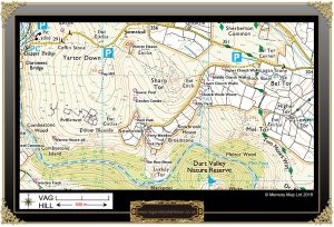
Although not marked on the modern OS map the termination of the ridge of Yartor Down is known as Vag Hill. For once there can be no confusion with this Dartmoor place-name as Vag was the vernacular term for the peaty turf found on the lower commons and although inferior to the rich peat of the uplands the ‘vags‘ were cut for domestic fuel. – Hemery, p.90. Therefore Vag Hill was most likely a place where vags were cut.
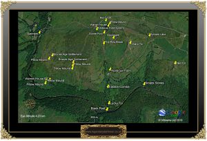
On the western and southern slopes of the hill are the remains of numerous Bronze Age hut circles, enclosures, reaves, medieval longhouses and the old Vag Hill Warren. For centuries rabbits were an important source of food and fur, consequently down through the ages various commercial and sporting warrens were established to breed the animal – Vag Hill was one such place. Linehan suggests that in fact there were two warrens on Vag Hill, one sited above Easdon Combe he called ‘The Warren House’ at OS grid ref. SX 6827 7329 and the other one on the lower SSW of the hill in what is known as the ‘Warren House Pit'(AKA Warren Pit) just above Combestone Island. at OS grid ref. SX 6754 7241. He also notes that these houses may have belonged to the warreners Meynell and Fursland. p.132.
The earliest documentary evidence of the warren was a lease which was drawn up on the 23rd of April 1623 between William, Earl of Bath and the two warreners, Richard Meynell and Walter Fursland of Bickington. In this document the bounds were clearly stated: “... concerning waste ground called Spitchwick Common lying between the river Darte (Dart) on the west and south east and from thence to Heartor (Yar Tor) to Cornetor (Corndon) on the north and east to the west of Rowbrook Hedge and so to Logator (Luckey Tor) on the east and so to the river of Darte with free liberty to make a warren there for the keeping and breeding and killing of rabbits. And also if any rabbits go over the Darte to the common there called Holne Common alias Holne Cleyves between Comson hedge and Whortaparke corner or to any place in the said Common of Spitchwicke the said Richard and Walter may kill them.” – Brewer, 2001, p.268. Apart from this lease of 1613 there is no other documentary evidence for the warren. However, in Widecombe Church there is an unmarked ledger stone belonging to Richard Meade who was said to be the warrener at Vag Hill and who died in the church as a result of the terrible thunder storm of 1638.
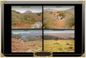
With regards to the most southerly of the warren sites at Warren House Pit English Heritages Pastscape Record describes this as being; “The remains of a building possibly a warrener’s house and six associated pillow mounds centred at SX 675 724. The building which seems to have collapsed both inwards and out wards measures in length and 3.8 m wide , with the walls standing to 1.5 m high. The north-west wall, which has roughly dressed drystone walls, is generally in good condition but the remainder has tumbled both internally and externally. There are six associated pillow mounds of which three are circular in shape the largest of which is 9 m diameter. The other conform to the usual elongated form and range from 19.5 m to 10 m long and between 5.5 m and 4.8 m wide and between 0.7 m and 1.1 m high, all are ditched.”
Hemery (p.579), contends that the main warrener’s house was in deed located here in Warren House Pit. This house he considers stood until around the mid 1800s and the last warrener was John Hannaford who used to hold secret cock fights here and for this very reason it was known as the ‘Cocky Pit‘. According to Mike Brown the ‘pit’ was once filled with water and a collapsible bridge constructed from branches and leaves or a mat placed across it. The idea being that when vermin such as stoats and weasels crossed in order to reach the nearby river bank to get a drink they fell in the pit and drowned. – p.3.
With regards to the second warren (?) the English Heritage Pastscape Record regards this as a ‘Deserted Medieval Site’ and do not mention any connection to a warren. It is described as consisting of; “a cluster of three coaxial rectangular buildings, probable longhouses, cut obliquely into a southwest facing slope together with associated fields, field boundaries, and cultivation ridges at the head of East Combe. The buildings are totally ruined, surviving only as earthwork hollows. The majority of the stone has been removed though odd pieces remain in place… A system of fields, probably associated with this settlement, extends up the slope to the north-west. Some of the field boundaries represent refurbished elements of the earlier Dartmeet reave system. The medieval elements comprise earth banks with ditches, which in places have formed into moderate lynchets. A series of cultivation ridges run across the fields parallel with the boundaries. There is no certainty however that the cultivation was contemporary with the occupation of the settlement.” One of the ancient longhouses was known as Easdon Cot, was the ‘lair’ of some sheep-stealers. This tale ends with the aggrieved farmers finally having a gutful of losing their sheep and so one day when the villains had gone out for the day they demolished the homestead. This sounds like a case of Dartmoor justice at its very best, don’t bother with the law they are very busy people, “us u’ll sort un ourzevles”
The remnants of the warren exist in the form of; “Twenty five pillow mounds exist on the south and eastern slope of Vag Hill (centred SX 6800 7280) of these twenty one are linear banks with parallel sides with rounded ends, three are circular and one is an extensive linear bank of 110 m length. Twelve linear mounds are oriented east to west, four north to south, three northwest to southeast, and three northeast to southwest. Most are ditched and range from 11.6 m to 30.5 m long with the exception of one 110 m long, and 4.5 m to 7.3 m wide, with the circular mounds ranging from 2.3 m to 8.8 m diameter. Eight are built into enclosure walls. Three vermin traps are associated with the warren. Each comprises a V shape funnel wall built against enclosure walls of between 8.5 and 10 m long and 0.4 m high. The example at SX 6743 7275 has a funnel on the interior and exterior. At SX 6808 7266 the funnel is on the interior only and at SX 6793 7252 it is on the exterior.” – Should anyone be interested in the locations of these features the OS grid re. are listed on the Pastscape Record.
Easdon Combe is the small valley between Yartor Down and Sharp Tor. At the head of this combe is Goose Pool which is the birth-place of the tiny Row Brook which almost invisibly trickles down through infant mires into the Dart. Halfway down the hillside the small brook enters the lands of Rowbrook Farm which in the Widecombe Tithe Apportionment of 1843 appears as Roborough. It was owned by one Margaret Baring and leased by William French. At that time the whole farm consisted of 40 enclosures covering some 56 acres the majority of which was devoted to arable land with some wastes, pastures and meadows. There are a few interesting enclosure names such as four called Church Walls, all arable fields in 1843. As the nearest church is two kilometres away at Leusdon it could well be that these enclosures at some time were gifted as charitable lands from which the proceeds went to a church. There is a Well Park which normally denotes an enclosure with a spring, in this case the Row Brook flows alongside its north eastern wall. Finally there is a tiny enclosure called Tick Park which apart from the obvious is a mystery.
The old Rowbrook nestles below the fields and only shyly pokes its farmhouse roof above the slope of the hill. It was at this farm that a tragic incident occurred in the February of 1892. William French, aged 14 and his younger brother Richard were sharing a bed and between five and six o’clock in the morning Richard got out of bed and began dressing. As he looked out of the window he saw three vivid flashes of lightening, he then went to wake his brother but found he could not be woken. He fetched his parents who discovered that although William’s body was still warm and limp he was dead. At the inquest Dr. R Ackerby stated that when he had carried out the post-mortem he could only conclude that death was due to a lightening strike whilst lying in bed as the left side of the deceased body showed indications of such an injury. The jury returned a verdict of ‘death by lightening strike’.
In the March of 1894 Richard French, farmer at Rowbrook appeared at Ashburton assizes charged with ‘furious driving in North Street’, Newton Abbot. P. C. Howard stated that he saw the defendant driving at 16 miles an hour and demanded he stop. French ignored the request and carried on driving, in his defence he stated it was a young horse which had become frightened and he could not stop it. – found guilty and fined twenty shillings.
The October of 1898 saw Richard French back at Ashburton, this time at the Police Court where he had summoned one Richard Norrish for assault at the London Inn, Ashburton. According to French he was sat at the bar when Norrish, without any provocation, dragged him off his stool and the proceeded to kick him on the legs and chest. So bad were his injuries that he was confined to bed for several days. Norrishs’ version was French was challenging everyone to a wrestling match and that on leaving the bar French collared him and then kicked him which began the “whole squabble’. – French was fined five shillings and costs, Norrish was fined ten shillings and costs.
On the 30th of November 1905 Richard French once again appeared at Ashburton Petty Sessions as ten days earlier he was charged with being drunk in charge of a horse. The arresting officer, P.C. Drew stated at the hearing that; “he saw the defendant near Holne Cross endeavouring to mount a horse. At each try he fell back in the mud. He got assistance and took the defendant to a farmhouse, and had him taken home in a conveyance.” For this heinous crime farmer French was fined six shilling and six pence along with eight shillings and six pence costs.
In 19311 Rowbrook farm along with Bradley Manor, near Newton Abbot was in the ownership of Cecil Mallaby Firth. He was a renown archaeologist who spent much of the year working for the Egyptian Government in the Saggara District where he discovered some noted 5,000 year tombs. During the First World War he served in the Egyptian Intelligence Service and was said to have been a contemporary of Lawrence of Arabia. In 1931 he was travelling back home for a holiday when aboard his ship he was taken ill and sent to London nursing home where he later died of pneumonia. It is also Rowbrook Farm that features in the famous Dartmoor legend which tells the tragic tale of the disappearance of young Jan Coo.
Below Rowbrook’s southern enclosure walls are some little glades of trees and one in particular is quite magical, three or so holly trees stand along with a small oak tree, their branches darkly shading some moss covered rocks. It would not take a lot of imagination to see a wizen old Druid officiating over some mystic rite below the gnarled trunks of the holly trees. Below the sound of the rushing Dart can be heard wafting up the hillside, on a calm day it sounds very much like the wind blowing through the trees, when the river is running high a definite booming sound can be heard which may well be the infamous, “Cry of the Dart“.
Logator, or Luckey Tor as it is now marked on the OS map, lays at the bottom of the hillside hidden amongst the trees. If ever anywhere on Dartmoor had more aliases than this place then I should love to see it. Over the years it has been called; Logator, Logator Rocks, Lug Tor, Lucky Tor, Luckey Tor, Looka Tor, and even Raven Rock. The latter name coming from the tradition that it was here that various nefarious characters would keep a ‘look out’ for danger whilst going about their poaching, sheep stealing or smuggling activities. Just to confuse things even more the summit of the huge outcrop was supposed to have been the home for golden eagles and in this light has earned itself the name of Eagle Rock.

As always, thanks to Keith Ryan of Dartmoor Cam for allowing me to use his photographs.
Brewer, D. 2002 Dartmoor Boundary Markers, Halsgrove Publishing, Tiverton.
Brown, M. 1998. Dartmoor Field Guide – Vol. 25. Plymouth:Dartmoor Press.
Butler, J. 1991 Dartmoor Atlas of Antiquities – Vol. 1, Devon Books, Exeter.
Hemery, E. 1983 High Dartmoor, Hale Publishing, London.
Linehan, C. 1966 Deserted Sites and Rabbit-Warrens on Dartmoor, Medieval Archaeology no.10.
 Legendary Dartmoor The many aspects past and present of Dartmoor


