“The fine form of Lether Tor, like a sentinel, guards the pass,… Although in altitude considerably less than the immense hill above the Walkham, this precipitous hill is in contour far more a true mountain.” – J. LL. W. Page, An Exploration of Dartmoor, p.150.
“The conspicuous feature in the view is the grand peak of Lether Tor, rising from a boulder strewn height, and clearly defined against the sky. Its name signifies the steep tor, the present form as heard on the Moor having the true sound of its Celtic appellation.” – William Crossing, Gems in a Granite Setting, p.156.
“The foliage fallen, Lether Tor’s grey castles and jagged slopes are visible, lifted against the west and seen through a lattice of innumerable boughs. Behind this mountain sinks the sun, now in an orange-tawny aureole above the purple, and now wrapped with sullen, lifeless cloud; now upon the clearness of summer twilights, and now through the flaming arms of a red mist.” – Eden Phillpotts, The Virgin in Judgment, p.301.
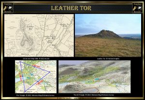
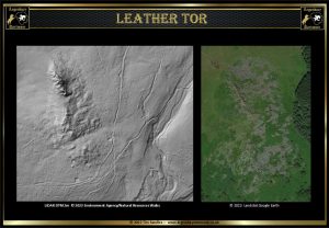
Leather tor is located at Ordnance Survey grid reference SX 5627 6998 and at its highest point stretches to 371 metres. The first documentary evidence of the place name Leather Tor can be found in the Calendar of Patent Rolls in 1317 where it appeared as Lodertorre. The English Place-Name Society agree with Crossing’s notion that the name has derived from the Cornish word ledr meaning a slope, cliff, or declivity which is an apt description of the tor. Over the centuries it has lent its name to nearby Leather Tor fam, Leather Tor, newtake, and Leather Tor bridge. Today the spelling of the name has changed from the old Lether Tor to Leather Tor.
It does not take a genius to see from most maps that the area around the north of Leather Tor once held some significance to Bronze Age man. There are the remains of numerous settlements, hut circles, a reave, a stone row, cairns, and to the south a kist. Baring Gould informs us that “great quantities of flints have been found there (Leather Tor), showing that at this spot there was a manufacturing of silex weapons and tools.” – A Book of Dartmoor, p.236. I love the thought that on a balmy summer’s day somebody once at on the tor chipping away at nodules of flint whilst admiring the view down the valley. Further on in time there was a nearby medieval settlement in the vicinity of Leather Tor. The accounts of the Bailiff of the Manor of Dartmoor show that in 1352 an acre of land known as Laddertorre was charged to one John Northway – Paul Rendell, Exploring Around Burrator, p.20. In 1511 the Abbot of Buckland, Thomas Whyte, granted the revision of a lease for the estate of Lader Torre to William and Jane Dunster along with a stamping mill.
Between the years 1800 and 1809 the Master General of His Majesty’s Ordnance ordered Lieutenant William Mudge to carry out a trigonometrical survey of the country. As part of the Dartmoor survey measurements from Leather Tor were taken to Cox Tor, Sampford Spiney steeple, Sheepstor steeple, Hessary Tor, Walkhampton Steeple, and Hurlestone Rock. In 1894 Robert Burnard noted in volume 4 of his Dartmoor Pictorial Records how Leather Tor , Sheepstor and Down Tor were equidistance from each other and were collectively known as “The Great Triangle.” As can be seen from the map below the distance between the tors do very nearly describe an equilateral triangle.
In 1903 the shareholders of the Yelverton and Princetown expressed their displeasure as to the management of the company. A meeting was arranged in the February of 1903 for the management to set forth their future plans for the development of the railway. One alarming suggestion being “With a station at Lowery Crossing, there would be a fine opportunity for the erection of an hotel on the southern slope of Leather Tor, which, with careful management would be as attractive as many of the hotels in Switzerland, and would have, owing to the popularity of Dartmoor with the medical profession, a chance of being full all year round.” – The Western Morning News, February 25th, 1903. Thankfully, this proposal never came to fruition.
In 1911 a twenty one year lease was granted to William Damarell which gave him “full power licence and authority.. to dig for quarry work and get granite and other stone and to dress and prepare for sale and to sell such granite upon and around all that parcel of land forming part of or situate near Leather Tor…” – Mike Brown, Dartmoor Fields Guide, Vol. 9, p.7. As can be seen on the southern slopes of the tor today there is much evidence of his labours.
Throughout time Leather Tor would have looked at an everchanging manmade landscape firstly fashioned by the prehistoric settlers. Then came the medieval farmers along with those in search of mineral wealth (as proven by the trial pits to the north of the tor and the blowing house to the south). In later years the view down the valley and its farms was erased by the flooding of the Burrator reservoir and the intrusion of the railway. Then came the quarrymen and the foresters and now by the influx of visitors. Throughout all these changes the ‘Sentinel’ of the Meavy Valley.
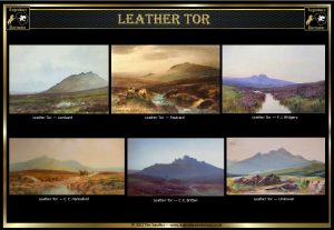
Leather Tor was the subject of many of the noted Dartmoor artists such as C. E. Brittan, F. J. Widgery, H. Truman (many of his works appeared as postcards), J. B. Clarke, W. S. Morrish and along with postcard manufacturers such as Frith, some of which can be seen above.. The Tor was also the favourite venue for several of the Dartmoor Hunt meets which included Trelawney’s Hounds, the Dartmoor Hounds, and Sperling’s Harriers. The clitters around the tor seem to have been favourite harbours of moorland foxes.
Leather Tor
“Grim watchman of the Moor, so stark so still,
Like some great warrior, hewn out in stone
By heathen hands, with all the ancient skill
Of an old sun god, seated on his throne!
Thy form the ever-changing mists surround
With pale robes swiftly turned into fairy gold
By hidden glories: and winds around
Thy head wild tales of wonderment unfold.
We live and die; thou standest sentinel
Of life and death, a sphinx-like monument
Pointing to heaven with a mute farewell
For days that pass, with joy and sorrow blent.
G. M. POTTER
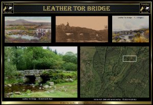
It would be rather amiss not to mention the nearby iconic Leather Tor clapper bridge which so many artists and photographers have depicted in their works. Eric Hemery described how “this fine clapper of two openings post-dates the old Mewy settlements… At a meeting of the Walkhampton Parish Council on the 20th of June 1833, it was “resolved by a majority that a bridge should be erected at a place called Riddipit Steps” and that a committee should be appointed to visit the spot and prepare a plan. No time was lost, for by the 25th of July, when the committee again met, the plan had been prepared and an estimate submitted for the work. At that meeting, therefore, it was “resolved that the tender of George Worth and William Mashford for £26 10s. be accepted.”” – High Dartmoor, p.126. R. H Worth was of the opinion that the old monastic track, the Abbot’s Way “passed down Raddick Lane to a bridge or ford at Leather Tor Bridge, thence along the course of the present road to Cross Gate..” – Worth’s Dartmoor, p.395. If you look at some of the early paintings and postcards of the bridge some of them depict the tor in the background which is probably why it was a favourite spot for them.
In the January of 1938 a meeting of the Devon Executive Committee of the Council for the Preservation of Rural England was held at Exeter. At the meeting reference to the Plymouth Corporation was made regarding the proposed planting of trees near Leather tor. Com. H. E. Wharton expressed his concern by saying that “he thought that there was a possibility of the planting blocking the view of Leather Tor Bridge. He understood it was proposed to plant the whole of the Meavy valley to the point called Devil’s Bridge. That would mean that access to the public would be stopped right across the valley. It was an extremely beautiful area. ” – The Western Morning News, January 28th. The bridge slightly differs from the most Dartmoor clapper bridges insomuch as it has parapets on each side and therefore is not always recognised as one. On the 28th of October 1987 the bridge was designated as a grade II structure and described as being a packhorse bridge which at onetime no doubt it was. The waters around the bridge were once noted for being a favourite spot for trout fishing as can be seen in the postcard above of the small boy fishing from the bridge
 Legendary Dartmoor The many aspects past and present of Dartmoor


