 Legendary Dartmoor The many aspects past and present of Dartmoor

Today Auswell Woods consist of just over 138 hectares of woodland and heathland which is now open to the public. Here there is evidence of prehistoric history, medieval history, post medieval history, and industrial archaeology. All of these surrounded by every aspect of nature anyone could wish for with the bonus of the river Dart flowing on the western flank. What now follows is a short overview of some of the aspects of Auswell Woods.
In the Patent Rolls 0f 1553 Auswell appeared as “Ausewell” and “Auswellwode” and in a Duchy of Cornwall record of 1606 as “Aspell Rock.” The placename has changed very little over the centuries and the only interpretation comes for “Aspell Rock,” meaning ‘Spring of the Aspen’. But this seems pretty implausible as where does the ‘Spring’ element come into this version? The local pronunciation of ‘hazel’ is ‘az ell’ and in this light Crossing suggested that “Hazel Tor, or, as it is now usually called, Ausewell Rock, probably did derive its name from the hazel, since it is placed on a hill that is still covered in places with trees and undergrowth. – Folklore and Legends of Dartmoor, p.129. Personally I think “The Spring of the Aspen” conjures up a sense of mystery and that’s my favourite. There certainly are two springs near to Ausewell Farm so maybe these were the originators of the name? But wherever the Ausewell was it has generously lent its name to Ausewell – Brake, Cairns, Common, Corner, Cross(roads), Cottages, Down, Farm, Gate, Island, Lodge, Marshes, Mine (aka Wheal Hazel),Rocks, and Woods.
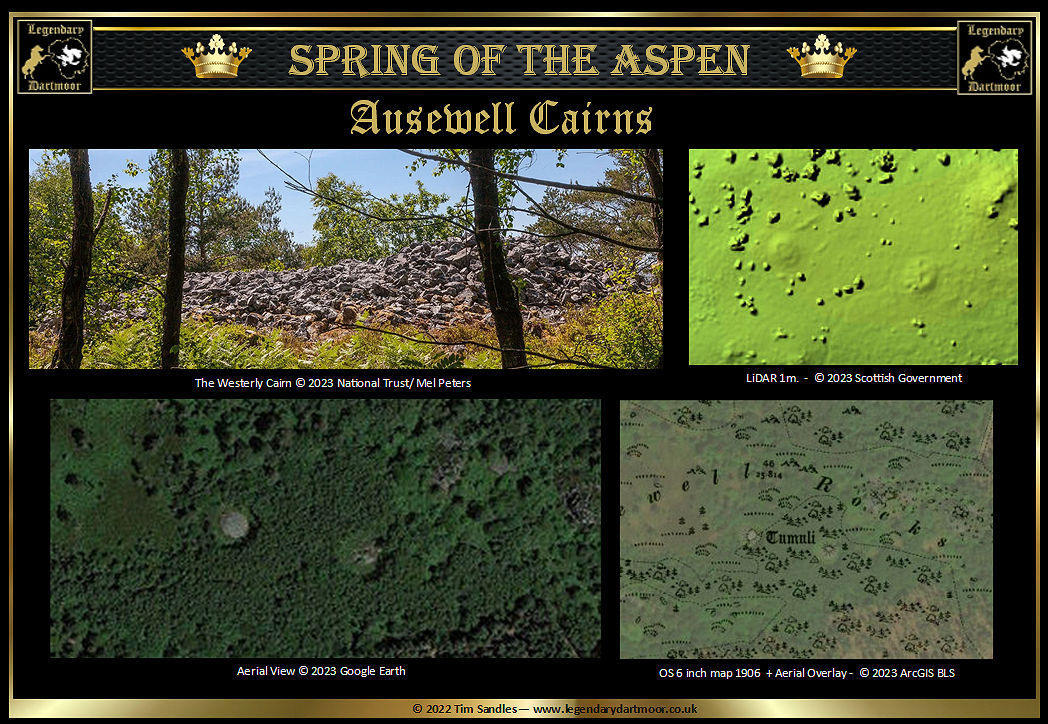
CAIRNS – Just below the summit of Auswell Rocks are a group of Bronze Age cairns located at Ordnance Survey grid reference (1) SX7347 7175 and (2) SX 7353 7173 and (3) SX 7361 7177. The western cairn (1) has a diameter of 15.72 metres and a height of 2.13 metres. It is encompassed by a dry stone wall on the summit and has suffered greatly at the hand of man with just a small portion remaining on the west side. The eastern cairn (2) has a diameter of 18.3 metres and rises to a maximum height of 2.4 metres. Again showing signs on intervention as there is a hollow in the centre with trenches running from the edge to the middle with three small chambers. There is a possible third cairn (3) which as yet has received no authenticated archaeological assessment. As Historic England note, what we see today is nothing like what the cairns would have originally looked like – “Despite significant disturbance through early excavations and deliberate re-modelling of the cairns in more recent times, and their location within a woodland with the threat of wind throw and root action, the two round cairns at Ausewell Rocks 500m south west of Ausewell Cross survive comparatively well...” – Historic England, online source.
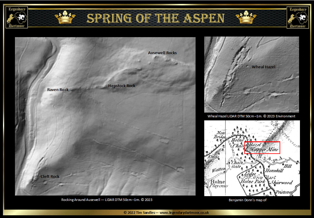
The cairns are located about 1 kilometre from the Iron Age ‘Castle’ of Boro Wood. P.F.S Amery considered that “If this was the site of a British village, as its name implies, then the cairns at Ausewell Rocks, the highest point of the hill of which Boro Wood is a spur, mark the place of burial of the tribe.” – T.D.A Vol. VI, p.263. There is very little evidence of any Bronze Age features on Boro camp and as the cairns on Auswell date to this period it is very unlikely they were “the place of burial of the tribe.” Amery also reproduced an old map of 1605 showing the Manor of Ashburton (see below). On this map you can see just to the right of Auswell Rock another cairn/barrow called “Whittabarrow.” Unfortunately the map was of an inverted pictorial nature which made the exact location of the barrow impossible. However the feature is showed somewhere to the north of Auswell Rocks, possibly near OS Grid Reference SX7370 7200. It has also been muted that the name “Whittbarrow” may refer to one of the Auswell Cairns. In 1960a field investigation of the area showed no signs of such a feature. – Heritage Gateway online source. At one time there was another monument near to the cairns in the form of an Ordnance Survey trig pillar.
COMMON – There is some scant evidence of Bronze Age settlement on the Down in the form of a hut circle and a possible enclosure located on a small parallel reave of a middle Bronze Age field system. Although today not strictly on the common is an Ashburton Parole stone located on the roadside by Highgrove. Such stones once marked the limit for which French Prisoners of War were allowed to reach from their billets at Ashburton. Should any prisoner venture past the stone and be captured they would be denied their comfortable billet and sent directly to Dartmoor Prison.
CORNER – It was here that a boundary stone was recorded in 1613 belonging to the bounds of Buckland-in-the-Moor was called “The Drosell Stone.” In later boundary surveys the name changed to Throshall Stone, Thrytle Stone, Drossil Stone and Ward to the key Stone. Today there is no sign of the stone. – Mike Brown, The Bounds of Buckland-in-the-Moor.
CROSS – This placename can be a bit confusing, if you look at a modern map then it’s easy to assume that the name refers to the road junction. However, 100m. north east of the junction is what was supposed to be the location of an old granite cross called ‘Bennecrosse’. Additionally some 240m. south-south-east of the junction was another cross called ‘Shortacrosse’ Both crosses were recorded in a document of 1605 listing the bounds of the Manor of Ashburton.
COTTAGES – At the northern end of Ausewell Wood are Ausewell Cottages near to which was a derelict barn (HER record MDV30683). At one time inside it were two horse drawn road sweeping machines that were purchased by William Whitley (Lord of Buckland Manor) from the Plymouth Corporation. It is said that the building was once a donkey smithy belonging to the 19th century and worked in conjunction with some nearby mining operations. Some occupiers of the cottages once showed Eric Hemery some “interesting remains” which were destroyed by some forestry workers and were taken to have once been an Iron Age settlement. They consisted of an internal circle of slabs measuring around 9m. in diameter and 4.5m. wide. This circle was the enclosed by a further circular wall situated around 4m. away. One of the occupants of the cottages prospected the area with a metal detector and found evidence of onetime iron smelting. There were also signs of an Iron Age field system. – Historic Dart, pp. 42-43. According to Heritage Gateway there are the remains of what could be an old granite cross located in the rockery of one of the cottages. It is muted that the cross could have originated from Buckland church, possibly from the finial or gable end.
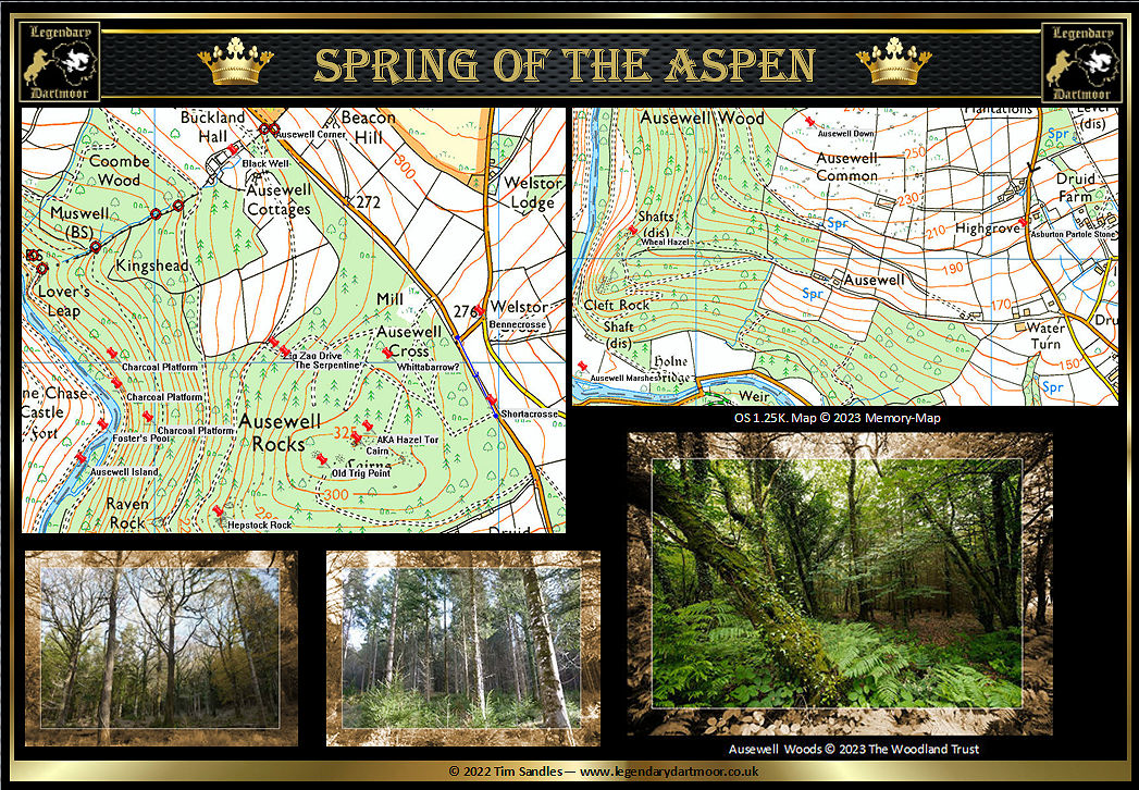
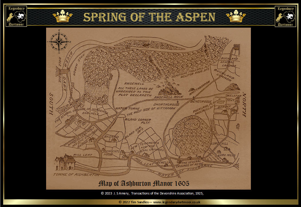
Industrial Activity – One of the earliest industries in Auswell wood was charcoal burning of which there is archaeological evidence dating back to the Bronze Age On the OS map above you can see the locations of three charcoal burning platforms. Initially the charcoal was used in the smelting of iron. Again look at the 1605 Ashburton Manor map above and you can see to the north of Auswell rocks the notation of “Iron Mill.” Similarly in a later period the charcoal was use to fuel the smelter for copper smelting. During the 19th century the oak timber from the woods was utilised in the shipbuilding industry. It is said that once felled the wood would be transported to the river Avon where it was taken to the nearby shipyards.+
MINE – This small copper mine was being worked in 1724. In 1763 ‘Haswell Mine’ was advertised for sale. As can be seen below, in 1765 the mine was depicted on Benjamin Donn’s map of Devon as ‘Hazel Copper Mine’. This was never a large mining operation and so to be marked on his map when other larger mines were omitted is slightly odd. In later years the mine became known simply as ‘Wheal Hazel’ and at this time the copper lodes were worked by means of two adits and a couple of shafts. The mine finally ceased work in 1860.
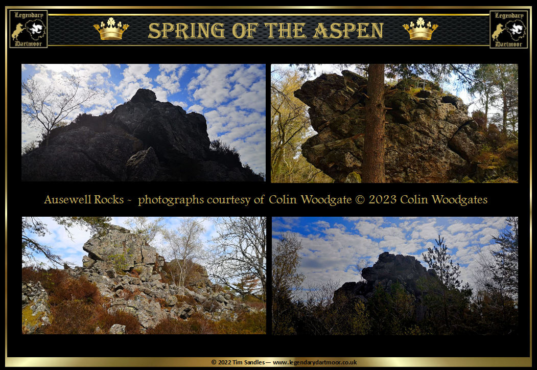
ROCKS – As Dartmoor ‘rocky hills’ go this one doesn’t seem to be able to decide on it name. Over time it has had the option of Ausewell (several spellings) Rock/s, Hazel Tor or Rock, Hazelwell Rocks and Lion Rock. It is interesting to get various author’s perspective of the everchanging landscape of the three granite masses that comprise Ausewell Rocks.
Sophie Dixon enthused in 1830 – “A mile further took us to Hazel-Wood, and after winding through various paths and fields, we again found ourselves tracing the ridge of a hill above the Dart, exactly beneath Hazel Tor, and Holne Chase, which is here descried in its full extent, almost surrounded by the river and covered with foliage. The prospect from this pathway in Hazel Wood, is exceedingly fine, commanding views of a country both diversified and beautiful...” – A journal of ten Days on Dartmoor, p.15.
John Murray 1851 remarked – “Auswell, or Hazel Tor, rising from a wood of firs on the other side of the road, and often ascended for the sake of the view south; and the little town of Ashburton nestled among its hills, south of south-south-east.” – Handbook for Travellers in Devon & Cornwall, p.58.
Charles Kingsley considered in 1891 – “Hazel Tor to me the finest thing I have seen, except the Upper Wye, which the whole place much resembles.” – His letters & Memories.., p.175.
John Chudleigh offered in 1892 – “Auswell or Hazel Rocks are in the woods opposite – three masses of rock with immense accumulations of cairn-like stones or boulders very difficult to scale. The view is to a great extent shut in by the woods.” – An Exploration of Dartmoor’s Antiquities, p.28.
J. Ll. W. Page gave us in 1895 – “The crag projecting from the wood and the lefthand is Hazel Tor, sometimes called Auswell Rock, also the Lion Rock, from its resemblance to the king of beasts, especially when viewed from the Buckfastleigh direction. ” – An Exploration of Dartmoor, p.230.
Eden Phillpotts wrote in 1920 – “Hazel Tor, as these names of porphyry were called, now rose like a ridge of little mountainous islets from a sea of dead heath and fern. The glories of the fall were at an end, and on an afternoon when the wind was still and the sky grey and near pressing down on the naked tree-tops.” – Orphan Dinah, pp. 47 – 48.
Eric Hemery bemoaned the fact in 1983 that “The blanketing by afforestation… has affected the stately crags of Auswell and represents, in a generation remarkable for diligently recording the antiquities of the Moor, a travesty of judgement and lack of appreciation.” – High Dartmoor, p.667.
It comes pretty clear from the above accounts that the outstanding feature of the rocks were the extensive views attained there and the great loss the afforestation has meant. It is interesting to note how in 1830 Sophie Dixon refers to Auswell Wood as Hazel Wood – again confirmation of Crossing’s ‘hazel’ association of the placename.
On reading the reports of many of the various fox hound hunts from the 1900s (such as the South Devons) it is clear that when put up from the Ausewell Woods many of the foxes always made for the scattered boulders around Ausewell Rocks to. On nearly every occasion ‘Old Charlie’ managed to escape his pursuers and lived to tell the tale. In the 1970s there was even a steeplechaser called “Hazel Tor.” As can be seen from the LiDAR image above, there are other craggy ‘rocks’ in the vicinity of Ausewell Rocks, namely Cleft Rock, Hepstock Rock, Raven Rock along with Lover’s Leap further north (not shown on the LiDAR).
WOOD – Today Auswell Woods comprises of a mixture of Ancient Woodland, Broad Woodland and very rare Temperate Rainforest sometimes referred to as Celtic Temperate Rainforests. It is estimated that there are now less than 1% of such rain forests in Great Britain today. Some experts have called the woods the “lost world” due to the fact of this rare temperate rainforest. One could write a book never mind such a short mention as this but there are two excellent resources online –Lost Rainforests of Britain and Moor Trees. Ausewell Woods are home to a whole diverse plethora of mammals, birds, insects, fish, plant life and fungi. Until fairly recently the whole area was privately owned and public access was in general denied. In the autumn of 2019 the estate was placed on the market with offers invited for in the region of £1,700,000. Along with the sale came the sporting stalking and fishing rights plus all the mineral rights excluding those under statue. A soon as the sale was announced a joint effort by the National Trust and Woodland Trust managed to raise the funds and purchased it in 2020.
The Trust uses a variety of management techniques which include selective tree felling, coppicing, and ride management. Selective tree felling involves the remove of diseased or overcrowded hence allowing more light to reach the forest floor thus encouraging the growth of ground flora. Coppicing is an ancient woodland management technique by which trees are cut back to the base level which in turn promotes new growth. Ride management involves maintaining the network of woodland paths paths and tracks ensuring they are kept clear and well-maintained. By this practice wildlife corridors are created, fire breaks are established and visitor access is achieved.
For more details on Ausewell Woods you can either visit the Woodland Trust website or the National Trust Website. Let’s hope that ‘Auswell’ ends well!