 Legendary Dartmoor The many aspects past and present of Dartmoor

If ever you want to ‘get down’ on Dartmoor there are numerous ‘down’ to get on. It is amazing how much of interest both past and present that can be found on the Dartmoor Downs. Thornworthy Down is a prime example. It covers roughly two Ordnance Survey grids within which are Bronze Age remains, later agricultural landscapes, industrial landscapes and a plethora of Dartmoor landscape features along with a few tales thrown in for good luck.
Thornworthy – This was many of the early Dartmoor ‘worthys to be found on and around the moor. The first record of the place-name was in the Rotuli Hundredorum (hundred Rolls) of 1275 in which it appeared as Thornwrthy. There are two elements to the name – ‘Thorn‘ and ‘Wrthy‘. With regards to the second element Clark-Hall in his Anglo Saxon dictionary lists the word – worõig as meaning an enclosed homestead, farm or curtilage, and this is the word from which ‘wrthy’ has derived. – p.419. The second element ‘thorn’ is derived from the Anglo Saxon word pricöorn, meaning ‘thorn tree’, thus giving the ‘worthy by the thorn tree’ or the ‘thorn tree enclosure’. Gover et. al. p.65. There are several surrounding landscape features that also have adopted the Thornworthy name; Thornworthy Bottom (SX 671 852), Brook (SX 699 856), Corner (SX 661 854), Down (SX 665 847), Farm/House (SX 670 849), Gate (SX 669 847), Mill (SX 672 844), Thornworthy Newtake (SX 663 849), Thornworthy Pound (SX 670 847) and Tor (SX 664 851).
Thornworthy Tor – If anything and judging by the photographs of the tor online and on Social Media this is a very overlooked tor, most people head for Kes Tor, visit the various Shoveldon Bronze Age monuments and then across to Scorhill Circle. But for the sake of adding an extra 0.5 kilometres to a walk the tor is well worth the effort. Many of the noted Dartmoor topographical have very little to say about the tor. Worth briefly mentions it by saying: “Closely adjacent to the rock-basin on Mis Tor is a mass of rock which has been completely rounded… Thornworthy Tor is similar but on a larger scale, the height from grass to the top of the block being 12 ft.” – p.25. In fact what he is talking about here is a rather splendid natural weather-formed Logan Stone which will actually still ‘log’ if enough force is used. On the old Ordnance Survey this logan is represented by an unmistakable round rock. The actual tor itself sits at an altitude of 424 metres and basically consists of one flatish outcrop upon which the logan stone sits looking akin the the bobble on a bobble hat. Mike Brown mentions that on the low shelf below the south side of the flat summit outcrop there is on two sunken panels an inscribed memorial which reads; ‘Bustle 1907 – 14’, ‘Leader 1908 – 14’, and ‘Test 1898 – 1909’, these are the names of three farm dogs which once were at Thornworthy. – p.4. however, on a visit a few years back I could find no sign of it. If ever you get caught out in a storm on the tor there is a handy little rock shelter on the south side.
Little Thornworthy Outcrop – At OS grid reference SX 6630 8487 sits a flat outcrop which compared to its big brother some 300 odd metres to the NNE is a lot smaller. However, it’s still large enough to be visible on most aerial photographs as can be seen below. Historically, no topographical writer mentions the outcrop, even Hemery and Crossing in their descriptions of Thornworthy Down neglect to remark upon it. The Ordnance Survey maps do acknowledge its existence but none name it, although that doesn’t mean much, – the old question when is an outcrop a tor or visa-versa?
Thornworthy Farm – Thornworthy has over the centuries seen many changes from a farm, to a country estate, and more recently a family home with it’s old barn converted into a boutique retreat and a base for Wildhorse Films. But going way back in time Hemery states that: “in 1782 John Ellis paid the Land Tax on Thornworthy Farm and ten years later in 1792 his son Richard was doing the same.” – p. 760. The Chagford Tithe Apportionment for 1843 shows that John Courtier was the owner and occupier of Thornworthy. At that time the holding consisted of 22 plots which in total comprised of 322 acres, 3 roods and 4 perches for which he paid £4 14 shillings and 6 pence a year. As can be seen from the map below there are a few interesting plot names amongst them. There are two ‘Honey Bags’ which present three possibilities as to the names, ‘sweet’ land meaning where bee hives were kept, productive land, or land with sticky or heavy soil. I would suggest out of the three it would be one of the last two interpretations. ‘Razor/Razer Close’ is an interesting and puzzling one, possibly referring to its shape or a field that needs to be close cropped? ‘Spade Close’ normally alludes to land which is shaped like a spade or land that needs to be cultivated by hand as opposed to ploughing and in this case probably the latter. ‘Shap’ the small sharp of pointed enclosure. There are then some obvious ones which are descriptive – New Park, Sandpit, Oak Tree Field, and Barn Park. It is worth pointing out that on such Tithe Apportionments they are always hand written which means they are in some cases hard to read and also the spelling can never be relied upon in both cases it can lead to misinterpretation. There is also a large newtake to the west of Thornworthy of which it is said that there were once trio of Bronze Age ritual blocking stones known as the ‘Three Boys’ and that two of these stones were removed to provide gateposts for the newtake – Crossing, 1987, p.56. – a clear case of despoiling. William Crossing also mentions that in the eastern enclosure walls of Thornworthy; “are some circular holed stones. Some of these may be unfinished millstones, left by those engaged in cutting them in consequence of the stone being found unsuitable for its intended purpose.” – 1990, p.259.
Hemery gives a description of some of the later farm features that once were at Thornworthy, some of which were quite unique. There was a “leat which was taken off from the Longstone Brook,”which fed into a large rectangular sheepwash that had granite flagstones. Now I could very-well be wrong but I think there is some confusion here? Why would you take a leat off the Longstone Brook which is about a kilometre away from the buildings when the Thornworthy Brook runs about only 200 metres away from them? On the aerial photograph below it looks as if a leat indeed does run from the Thornworthy Brook to the out buildings.
When the wash was not in use a hatch was opened on the lower end stayed open allowing the water to flow into a launder below and then into the barn where it powered much of the early machinery such as a threshing machine etc. Prior to the water power much of the work was done by horses in an octagonal house. Here a horse would have been attached to a rotating beam which then drove such machinery as an oat crusher. Sometime during the Second World War there was a drive to collect as much iron as possible and this led to much of the metal parts of these buildings being removed. – p.761.
Reading through old newspaper articles a good picture of events and farming activities at Thornworthy can be gleaned. In the January of 1846 it was announced that John Courtier of Thornworthy was to be let by tender for a term of seven or ten years from the following Lady Day (March 25th). Described as consisting of about 322 acres of meadow, arable and pastureland in a good state of cultivation. In the July of 1847 there was another notice that John Courtier was again letting of Thornworthy this time for a period of ten or fourteen years from the following Lady Day. It was stated that there was 84 acres of watered meadow, Pasture and Arable land along with 238 acres of excellent enclosed newtake for the depasturage of general farm livestock. It is interesting to see that in the second notice it stated that the 322 acres included 238 acres of the newtake, a fact not mentioned initially.
It seems that for a short period Thornworthy was reoccupied by a Mr. John Hooper but in the February of 1849 a notice appeared in the local press saying that on the 15th of March Mr. J. Hooper was holding a farm sale as he was about to quit the farm. For sale was; 1 cow and calf, 1 barren heifer, 1 6 year old black mare, 1 black mare 5 years old, both good in saddle or harness. 1 horse of all work, 2 mares in foal, 2 colts 5 years old, 2 colts 4 years old, 2 entire 3 year old cart colts 16 hands high, 3 carts, a three-knife chaff cutter, sulls, drags, barrows and other implements. 120 bags Early Reds, Late Reds, Jilly Flowers and Irish white potatoes, all the furze growing in the New Park, some furze in ricks.
As can be gathered at this time apart from a few cattle the majority of the livestock consisted of various work horses. The 16 hand cart colts were about the average size for Dartmoor’s cart horses and clearly all were kept for various tasks. Potatoes were also a going concern on the farm with various moorland varieties being grown. Incidentally, a sull or ‘Zole’ in the vernacular is a type of early swing plough often used on Dartmoor.
Moving on then to the March of 1855 when John Hooper was advertising a farm auction on the 20th and was selling on behalf of William Hooper who was quitting the farm. For sale were; 3 heifers and calves, 6 steers, 3 years old, 2 steers, 2.5 years old, 2 cows and heifers in calf, I entire cart horse, 7 years old, grey and 16 hand high with immense power and remarkably light action, 2 mares in foal by the same horse, 1 five year old colt which was broken on the farm, 3 useful 3 year old cart colts, 1 3 year old pony, 1 slip pig, 4 breeding geese and their eggs, a winnowing machine, 3 large ricks of furze. The entire cart horse it seems was bred from one called ‘Terror’ which in 1844 won the premium award given by the Royal Agricultural Society.
In 1873 John Hooper had advertised Thornworthy for sale at auction. This time however it was advertised as an estate and very much aimed at the sporting gentry. Sated as comprising of 322 acres of watered meadow, arable and down land all within a ring fence. There was two years left on the rented land which brought in an annual income of £63. But now there was mention that the game was reserved for the landlord and that there was good coursing, partridge and snipe shooting. Also the South Teign river which formed part of the boundary afforded good trout fishing.
The following year the land were up again to be let for a term of seven to ten years from the following Lady Day and encompassed. the usual 322 acres. However the shooting and fishing rights were to be reserved for the landlord, in other words just the agricultural lands were up for grabs. By this time the estate was owned by Robert Standerwick.
By the November of 1875 the farm bailiff was Mr. Flood and at the Moretonhampstead Assizes he had summoned William Ellis for trespassing on lands at Thornworthy in search of game – fined £1 and costs. In the September of 1876 Mr. Flood advertised that he had lost three ewes which were marked with a top cut on the near ear and signed upright R. S. across, reasonable expenses paid.
Over the next decade or so a succession of tenants farmed at Thornworthy and the estate remained in the ownership of the Standerwicks. Then in the July of 1906 the estate was advertised for a private sale. The house contained 16 rooms, domestic offices and tastefully laid out grounds along with a carriage drive, vinery, conservatory lawns, shrubberies,, vegetable and fruit gardens. The buildings included detached stabling, coach hose, two cottages, an entrance lodge and farm buildings plus the usual 322 acres of land.
Clearly there were no takers as in the August of 1907 the estate was up for sale at a public auction. This time the sale was successful and was purchased by Mr.H. B. Varwell and his family. The following year Mr. Varwell was inviting tenders for extensive alterations including the construction of a new farm house with additions to the existing residence.
One of the later farmers at Thornworthy was Will Hutchings who had decided to quit in the September of 1922. The auction notice for his livestock advertised; SHEEP; 75 two, four and six toothed Dartmoor breeding ewes, 30 Exmoor two, four and six toothed breeding ewes, 13 Dartmoor wethers, 12 Exmoor wethers, 55 Dartmoor and Exmoor lambs, 1 Exmoor ram. CATTLE; 2 in-calf cows, 3 milking cows in calf, 1 heifer in calf, 12 steers and heifers from 2 to 3 years old, 7 steers 18 months to 2 years, 2 yearlings, 1 well-bred South Devon Bull. PIGS; 1 sow due to farrow and 7 slip pigs. HORSES; chestnut mare, 5 years old, 15.5 h.h., bay gelding, 6 years old, 15.2 h.h., cart colt, 2 years old. DARTMOOR PONIES; 40, various ages. ALSO; 40 head of poultry, 1.5 acres potatoes, in-ground, various farm implements.
As can be seen from previous sales by this time there had been a huge increase in livestock numbers and breeds with sheep, both dairy and beef cattle and a large number of horses, especially the 40 Dartmoor Ponies. This is the first time that the actual breeds were mentioned as in Dartmoor and Exmoor sheep along with a South Devon bull. What is noteworthy also is that at this time the Blackface Sheep were very much a popular breed but here they were sticking to the local breeds.


Events and Miscellany – around the Thornworthy area are a mixture of places and landscape features to which are attached various stories, some factual, some fictional and one tragic. So, to start with the earliest;
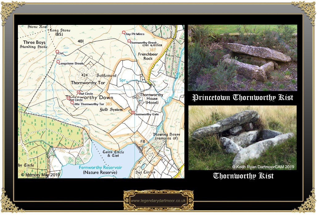
The Thornworthy Kists, if you look at a modern Ordnance Survey map at grid reference SX 6674 8433 plainly marked is a cairn circle and cist (AKA kist or kistvaen). This is part of a larger feature which; “includes a cairn containing a cist situated on a gentle south facing slope overlooking Fernworthy Reservoir. The cairn survives as a circular bank up to 2.75 m wide and 0.8 m high, with overall dimensions of 12.8 m in diameter. A second raised area within this bank lies adjacent to a cist which measures 1.02 m long by 0.52 m wide internally and is 0.73 m deep. The cist is orientated north west to south east and is partially obscured by the original coverstone which was displaced in 1878 when the cairn was excavated. These excavations revealed that the cairn had not been previously disturbed and within the mound two cists were found. A flint knife and scraper were recovered from the central cist. The second cist lay to the south east of the first but was ransacked before its excavation could be completed.” – Heritage Gateway. Both of the kists were investigated in 1879 by kind permission of Mr. Standerwick the land owner, initially the work was carried out by an antiquarian called Samuel Slade who was later joined by William Pengelly. So why do the Ordnance Survey state ‘cairn circle and kists’? The simple answer to that is that the second, smaller kist is no longer there. In the March of 1880 Mr. Pengelly, being the then curator of Torquay Museum managed to persuade Mr. Standerwick to let him remove the small kist and take it to his museum for display. Then in 2004, as it was supposedly ‘in the way’ at Torquay Museum it was removed to become part of the Jack Wigmore’s memorial garden which is located at the back of the Princetown Visitor’s Centre. Having been desecrated once surely as a fitting memorial to the one-time Chairman of the National Park Authority it could have been placed back in its original location for people to see both monuments in their original context?
Thornworthy Blowing House. William Crossing mentioned that; “Below Thornworthy, in a narrow glen through which the South Teign leaves the wastes.. is the stream-work and blowing house. There are in fact two mining buildings, and a good example of a trough and mould stone.” – p.259. Today the site is located within the trees and very little evidence remains of the previous tinning activity. Both the trough and mould stone have vanished and all that remains are the remnant walls measuring 10.4 by 4.4 metres and quantities of slag first found in 1920 when a reservoir pipeline was being built.
Thornworthy Thrift – One of the many Dartmoor tales relates how at one time there were two families living in small cottages by the old blowing house. One of the families were of the hard working and industrious type whilst the other was the complete opposite. As time went by the hard working family began taking on a gaunt and tired look whilst the idler and his family just grew fatter and fatter. This puzzled many of the neighbouring folk and then one day a local farmer’s sheep went missing. In view of the situation at the two cottages suspicion immediately fell on the waster and his tribe. A band of farmers marched up to their cott in search of signs of the missing sheep. But search as they might there was nothing to show of the beast, but just as they were about to leave one man spotted a row of covered granite blocks and on investigation found them full of salted slugs -it transpired that the family had thrived by eating such succulent (?) delicacies which are supposedly full of protein.
Thornworthy House – One of the famous guests which lived there was Mary Wesley the author of ‘The Camomile Lawn’. There is reference in her book of an escapee from Dartmoor Prison and apparently whilst at Thornworthy she actually used to leave the house unlocked and a set of clothes on a kitchen chair just in case an escaped prisoner should happen by.
The Teign Naturalist Field Club – In the July of 1909 around forty ladies and friends from the club were visiting the Chagford area. They had travelled by train to Moretonhampstead and then by carriages to visit various places of interest in the area. Mr Varwell, who was a member of the club, kindly provided afternoon tea for the ladies at Thornworthy. On the way back to Moretonhampstead one of the brakes was ascending a hill when part of the carriage harness broke and it began to run backwards down the hill. The horses then began to panic and somehow managed to turn around in the shafts thus upsetting the carriage. The result of which twelve of the ladies were ejected from the carriage and landed on a nearby roadside bank, two of which suffered injury. A motor bus was then sent to collect them and ferry them on to the station.
The Hapless Housemaid – A sad and tragic event took place at Thornworthy House on the 11th of September 1913 when a local police constable was called to the house. He had been summoned due to the discovery of a dead baby girl wrapped in a parcel inside a tin trunk in a housemaids room. Later investigations determined that the infant belonged to Emma Keates who had given birth to it in her room. She was later charged with ‘concealing the birth of her child, she eventually ended up at the Devon Assizes at Exeter where she admitted the charge. Fortunately it was ruled that she should be released on the condition that she went to live in the Exeter ‘Home of Refuge’. – for the full story see – HERE.
The Shocking Incident – In the July of 1935 Harry Mears from Thornworthy was having a hay rick built in a field at Parford, near Drewsteignton. He was helped by his sons and several other men when a mighty thunderstorm burst from the heavens. At the time the hay rick was being constructed near an electricity pole when a vivid flash streaked from the sky. The result being that Harry Mears who was holding a steadying rick rope received a six or seven inch burn down his left leg and was knocked temporarily unconscious. Even worse, a Mr. Moor was holding the head of a mule whilst the hay was being loaded and immediately the lightening struck the mule dropped down dead and “commenced to singe.”
Teign -e-ver Clapper Bridge – In 1826 the original clapper bridge was swept away during a terrific storm and in Will Hutchings’ obituary of March 1928 it was mentioned that; “He came from Chagford over sixty years ago from Belstone, and farmed at Thorn and Thornworthy. It will be remembered that for the benefit of neighbours and family he built the footbridge across the North Teign on the path below Teigncombe Moor Gate leading to Gidleigh, which enabled them to go to church.” So, partially right, he restored the Teign-e-ver Clapper, which still to this day is a convenient crossing point over the North Teign river.

Brown, M. 1999. Dartmoor Field Guides – Vol. 47. Plymouth: Dartmoor Press.
Clark Hall, J. R. 2004 A Concise Anglo-Saxon Dictionary, Cambridge University Press, Canada.
Crossing, W. 1987. Stones of Dartmoor. Brixham; Quay Publications.
Crossing, W. 1990. Crossing’s Guide to Dartmoor. Newton Abbot: Peninsula Press.
Gover, J. E. B. et. al. 1992 The Place Names of Devon. English Place-Name Society, Nottingham.
Hemery, E. 1983. High Dartmoor. London: Robert Hale.
Worth, R. H. 1998. Worth’s Dartmoor. Newton Abbot: David and Charles.
I am looking forward to be visiting this place soon.
I have heard so much of this place. It is amazing that you can both see its history and the present.