 Legendary Dartmoor The many aspects past and present of Dartmoor

|
On Cawsand Beacon.
Rolling o’er the purple heather, In the glorious Summer weather, Staining lips with whortleberries, Sweet as any figs or cherries.
Sipping from the crystal stream, Lying on the banks to dream, Watching skylarks soar above Singing, with them, strains of love. |
Gazing over boundless plain,
List’ning to the sweet refrain Of the rivulets and rills As they flow by distant hills;
Hearing voices, strange and low, Mystic tones that come and go, Seeing tors salute each other, Every one a friend and brother.
Elias Tozer – 1873 |
‘Cosdon’s immensity is apparent rather than real; for Nature has built her, rounded her and ordered her uprising with such cunning architecture that the hill’s dimensions, in their perfection of proportion and balance, imply an amplitude that they do not possess. The mount attains to a sublimity and asserts a vastness beyond man’s sense to refute, though within the measuring rod’s power to deny’ – Eden Phillpotts, The Beacon.
As you can tell from the extract above, Cosdon is a mighty hill which at one time was thought to be the highest point on Dartmoor. Admittedly it can boast a soaring and respectable elevation of 550m but at the final reckoning is beaten by its neighbour who sits and smirks to the south west – High Willhays (621m).
Having lost the height dispute, Cosdon can claim the victor’s crown when it comes to archaeological and historical interest. Every flank of this awesome dome is literally peppered with relics of man’s past activities and beliefs. There can be no question that to prehistoric man Cosdon represented something sacred, an observation that is emphasised by the number of ancient ritual monuments located on and around the hill.
Cosdon first appears in the written record in 1240 when listed as both the starting and finishing place of the Perambulation of the Forest bounds. In this document the hill is named as Hoga de Cossdonne which suggests that it was known prior to that date as merely Cossdonne. The Place-Name Society suggest that the name consists of two elements; the first being Coss which was a personal name, namely Cost(a) and the second is dun which means ‘hill’, thus giving ‘Cost(a)’s Hill’, (Gover et al. 1998, p.448). The word hoga is a Latinised from of the Old English word hoh, (Clark Hall, 2004, p.189) which means a heel or point of land, Ekwall, (1980, p.244) also considers the same. Hemery, p.835 however considers that hoh means a local boundary which accords with the idea of the hill being a Forest bound of 1240. The first option seems the most logical but either way the original term simply means the ‘point of land of ‘Cost(a)’s hill’. Over the centuries the place-name has ranged from Costendoune (1240), Cosson (1608), Cawson-hill (1797) and the more familiar name of Cawsand Beacon. One writer of the early 1800s names the hill as Cawsand Pike which admittedly comes from a book about Somerset, (Phelps, 1836, p.116)
But long before 1240 Cosdon may well have been known as ‘hill of the dead’ by Bronze Age Man as a look at the map in the picture gallery below will reveal. However, even before these folk set foot on the moor their ancestors were already treading Cosdon’s vast slopes as the Neolithic flint axe found at the western foot proves, (Pettit, 1974, p.16). But back to the Bronze Age, there are nine settlements located around the western edges of Cosdon which either consist of five single enclosure, three multiple enclosures and one partial enclosure, (Butler, 1991, p.200). Along with the settlements are two associated reaves, the first being known as the Taw Marsh reave which runs from White Hill up to a point almost due west of the northerly cairns on Cosdon’s summit. This along with the Kennon Reave system appears to have marked out a specific tribal territory which was located between Taw Marsh and Whitemoor Marsh withy Cosdon being the central focus. It has been suggested that this territory is one of five where, during the Bronze Age period, people settled with the most southerly of these communities being 25km away to the south, (Fleming, 2008 p.69). Taking the settlements out of the equation the surrounds of the hill show evidence of numerous cairns, kistvaens, stone rows and a possible stone circle all of which are listed on the table below along with their English Heritage record number should anyone want to read them:
| FEATURE | OS GRID REF. | EH PASTSCAPE RECORD |
| Cairn | SX 63480 93241 | ADS Record ID – NMR_NATINV-444179 |
| Stone Circle (now disappeared) | SX 63660 93231 | ADS Record ID – NMR_NATINV-444139 |
| Kistvaen (Black Prince’s Tomb) | SX 63540 93166 | ADS Record ID – NMR_NATINV-444144 |
| Cairn and Kistvaen | SX 63600 93061 | ADS Record ID – NMR_NATINV-444147 |
| Cairnfield – at least 8 cairns | SX 62900 92698 | ADS Record ID – NMR_NATINV-1394706 |
| Cairn | SX 63380 92471 | ADS Record ID – NMR_NATINV-1394823 |
| Cairn | SX 63310 92341 | ADS Record ID – NMR_NATINV-444214 |
| Cairns | SX 63200 91751 | ADS Record ID – NMR_NATINV-444204 |
| Cairn | SX 63678 91678 | ADS Record ID – NMR_NATINV-444167 |
| Cairn | SX 63720 91696 | ADS Record ID – NMR_NATINV-444212 |
| Cairn and Kistvaen | SX 63720 91641 | ADS Record ID – NMR_NATINV-444213 |
| Beacon Cairn | SX 63608 91473 | ADS Record ID – NMR_NATINV-444172 |
| Cairn, Kistvaen and Stone Row | SX 64313 91606 | ADS Record ID – NMR_NATINV-444168 |
| Kistvaens – 2 | SX 63600 91201 | ADS Record ID – NMR_NATINV-444171 |
| Cairnfield – 10 cairns | SX 64890 91831 | ADS Record ID – NMR_NATINV-1214351 |
| Cairnfield – 25 cairns | SX 64800 91391 | ADS Record ID – NMR_NATINV-1213681 |
| Cairn | SX 65028 91428 | ADS Record ID – NMR_NATINV-444060. |
| Cairnfield – 8 cairns | SX 64360 90611 | ADS Record ID – NMR_NATINV-1214239. |
| Cairn Cemetery – 6 cairns | SX 64470 90361 | ADS Record ID – NMR_NATINV-1214359 |
As with many parts of Dartmoor many of the prehistoric monuments have been damaged with the stone taken for other purposes such a enclosure walling etc and in some cases all that remains today is the place-name. Eight Rocks/Stones is such an example as Leger Gordon explains, (1954, p.17): ‘The Eight Stones’, another fine circle which once stood upon a shoulder of Cosdon Beacon above Sticklepath, was completely removed to provide walls for a new enclosure‘. Of all the monuments that remain the triple stone row with its associated kist and cairn has to be the most spectacular. Locally these relics are known as ‘The Cemetery’ and lay nestled in the shadow of Cosdon’s eastern flank where miraculously they have escaped the despoilers. The stone row consists of three lines of uprights which run for between 146 and 176.5m (depending on whether or not the bottom slab is deemed to have been a blocking stone) and are set about 1.4m apart. The row runs uphill and terminates at what is now a ruined cairn, the middle of the three rows is aligned centrally with the cairn. What puts this cairn apart from other Dartmoor examples is that inside it contains a pair of kistvaens which are co-joined by means of common end slab, in effect a his and hers grave?
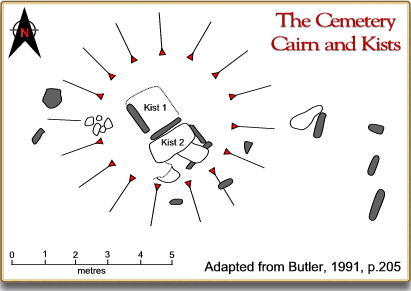
Today there is evidence of at least 68 cairns dotted on and around Cosdon, in all likelihood there were more but the rest have been dismantled or destroyed. Where there are cairns there will be kistvaens and apart from those at The Cemetery other examples can be found on Cosdon. The most northerly of these hides an intriguing story, for some reason the kist is known as ‘The Black Prince’s Tomb’ (St. Ledger-Gordon, 1972, p.58) and most frustratingly nobody has suggested a reason why. Clearly there is some tale attached to it which concerns a knight of some sort? Other legends have attached themselves to some of Cosdon’s antiquities, for example the long lost Eight Rocks were once supposed to dance upon hearing the sound of South Tawton’s church bells, (Crossing, 1990, p.213). Somewhere on the crest of Cosdon was what Crossing called, ‘Cosdon House’ and it was here that a gang of sheep stealers once lived and carried out their raids on the local flocks. Eventually, a local moorman known as Samson Bow decided enough was enough and lured them into the treacherous mire of nearby Raybarrow Pool, (Crossing, 1990, p.216). Annoying enough, William Crossing fails to state the location of Cosdon House but Hemery, (1983, p.835) states that “There are remains of sepulchral monuments on the summit, the OS triangulation stone having been placed on the summit cairn; on the north-west side is the relic of a shelter which, according to Crossing, was once called ‘Cosdon House.” Butler, (1991, p.206) lists all of the summit cairns and the only one which lies on the north-west side of the summit is described as being:
“probably the first structure to be built as it occupies the very highest point and now supports a trig. station. The original dimensions are impossible to estimate as the stones have been thrown out in all directions, partly to accommodate a number of shelters around the edge, but it is now up to 3m high and spread to 27m across. A circular setting at the eastern foot of the cairn may be the foundations of a hut circle or a more modern erection…”
Therefore could this been the ‘Cosdon House’ from the legend? The crucial factor is in Hemery’s wording, when he says “on the north west side,” is he pertaining to the north-west side of the cairn or the north-west side of the hill? If it is the former then this was the house where the sheep stealers were meant to have lived, if not it has been lost to the ravages of time. Having just found a footnote of Hemery’s (1983, p. 794) the above question can be answered. In his section on Raybarrow Pool the footnote relates the story of Samson Bow and he states; “I know of no signs of any former building on Cosdon, which might have been called ‘Cosdon House’, other than the shelter built into the north-west of the summit cairn,”
Many writers still refer to the hill as Cosdon/Cawsand Beacon which considering its height and visibility suggests that at one time beacon fires were lit here. Crossing (1994, p.20) notes: ‘On the very summit of the hill is a huge cairn, and other remains of a bygone age, grey and weather-beaten. In medieval times upon this point of vantage the signal fires were lit, and it is known as Cosdon Beacon to this day‘. The far stretching views that Cosdon commands would certainly make it a valuable link in any beacon chain as Rowe points out:
‘Few places could have been chosen more admirably adapted for the purpose of rousing the whole neighbourhood than this, where the eye can sweep three-fourths of the entire horizon, and look forth upon the greatest part of North Devon, with large portions of the Western and Eastern districts of the county, and some of the loftier points of Cornwall, Somerset, and Dorset. Exmoor looms large and distinct in the north, and it is said that the Bristol Channel can be seen on a clear day, which is perfectly possible, while there is no doubt that the English Channel, off Teignmouth, is distinctly visible. Imagine, then, the bale fire kindled on this commanding eminence…‘, (1985, p.87).
In all probability Cosdon Beacon was lit at the time of the approaching Spanish Armada in order to muster the men of Devon to arms and to defend their county and country.
No matter which way you approach the summit of Cosdon it will be a slog as can be seen from the various directional profiles below. Luckily when coming from the Belstone or northern end there are a few things to distract from the toil. There can be no question that prehistoric man had been very busy in and around the hill but so were he descendants in later centuries. Cosdon’s north western slope has been the focus for a rabbit warren as the 19 buries or pillow mounds suggest. The land upon which the warren was first established was leased from the Duchy of Cornwall sometime in the 1800s. In 1875 a case was brought to the magistrates which involved a warren owner named Fewings. He leased what was described as a warren on, ‘part of Belstone Common‘ to which the locals took exception. In their eyes this was common land and should not have been exclusively given over to a warren. Accordingly some of the villagers went into the warren and shot a large number of rabbits which at the time was said by Fewings to number in the thousands. If this was, and there is no reason to think otherwise, the same Skaigh Warren it did not last much longer because in 1876 the Duchy rescinded the license for ‘Belstone Rabbit Warren’. Located near the warren wall corner (Skaigh Corner) (OS grid ref. SX 63378 93340) is a boundary stone known as ‘Stumpy Post and is inscribed with DC1 on its north side and SZ1 on the south. Another stone standing in Foxes Holt (OS grid ref. SX 63990 92451) is marked DC2 and SZ2, both stones and a further one that has now vanished were erected in 1885 to mark the disputed bounds between the Duchy Lands and the folks of South Zeal, (Brewer, 2002, pp. 47 – 48).
To the west of the warren buries lies Ivy Tor Water which for many years was wrongly named on the Ordnance Survey map, nearby is Ivy Tor where just upstream are the remains of the old Ivy Tor Copper mine. Work began here in the 1840s when an adit was driven into the hillside and met with mispickel, bismuth and copper ore lodes. To exploit this mineral wealth a shaft was sunk in 1845 and by 1851 the adit cross cut had been enlarged by 27 fathoms to a level 12 fathoms east and west of one of the lodes. It was reported in 1854 that the miners had driven into a small chamber whose walls were crusted with crystals, similar to that found in the Virtuous Lady mine. Despite various attempts at searching deeper for the mineral lodes the mine was incorporated into the sett of Belstone Consols in 1866, (Hamilton Jenkin, 2005, pp. 101 -102).
On the north western flank of Cosdon in an area known as Queenie Meads rises a small brook which is unmarked by the Ordnance Survey called the ‘Lady Brook’. This for a while was recorded by their maps as Ivy Tor Water which as noted above is further north. The name is actually a derivative of the less prosaically named Lud Brook which dates back to at least 1383 when it appears in a court roll of that year. In its lower reaches rises a smallish granite outcrop which is known as Ladybrook Tor and at one time its clitter was called Foxes Holt which is not to be confused with the similarly named Foxes Holt on the eastern side of Cosdon. This is an area that has also been worked by the tinners as can be deduced by the tin workings which can be found near the upper reaches of the brook, (Hemery, 1983, p.832).
Just south of the Lady Brook is another small stream which again is unnamed by the Ordnance Survey and according to Hemery was known as the Golden Spring and is described by Hemery thus: ‘Trickling between the rocks of the huge clitter on Taw Plain is water from a feather-bed mire on the valley side; ice-cool and pure, it is known as Golden Spring‘, (1983, p.848). However, there is some confusion over this as on a map drawn for the Belstone Millennium Book the Golden Spring is recorded as being on the north side of the River Taw just above the weir, (Walpole, 2002, map). Further evidence of tin extraction was located just north of the confluence of this small feeder and the Taw river in the form of an entry in the court rolls of 1521. This document shows that on 4 May 1521, 13 Henry VIII was charging, ‘3d for a myll called Kakking Myll and a Myll called Blowing Myll, two acres of land lying in the Forest in the west part of Tawe so let to Thomas Takfield‘. Another entry from 1835 shows that Thomas Takfield was still leasing the mill for 3d, (Hemery, 1983, p.847). A ‘Kakking Myll’ or more commonly a Knacking Mill was where in simple terms the ore was crushed prior to smelting. A Blowing Myll or blowing house was basically a late medieval tinner’s workshop where the ore was smelted and cast into ingots.
Another use man had put ‘The Dome of Dartmoor’ to in more recent times was that of a shooting moor, not that long ago Cosdon was home to a population of black game or grouse which along with the occasional stray deer made for a good days sport. Today the only vestiges of this activity are a few granite shooting butts which can be found on the northern and eastern flanks of the hill. One is located about 274m east north east of the lone tree on the northern slopes of Cosdon, (Brown, 1998, Vol. 36, p.12). According to Hemery another butt is located north west of the DC2 boundstone, this is also close to another mysterious, ‘chamber-like object now silted up and mire filled‘, (1983, p.834). Whilst vaguely on the subject of wildlife, on a couple of visits during the late 1990s I saw on both occasions a grey squirrel scampering around the clitter. It appeared that it became part of the scenery as several other walkers also met in on their visits. One would have thought that there was not enough food to be found on the hill to warrant such familiarity on the squirrel’s part?
Should anyone be interested in alignments and there is an interesting one or the other on Cosdon, if a line is drawn from the most northerly cairn marked on the OS map in a north easterly direction it will intersect through Firestone Cross and Brandis Cross. These are not crosses in the Christian sense but crossroads in the Devonshire sense. Yes, so what? Well, it has been argued by Watkins (1995, p.110) that beacon fires were used in prehistoric times to guide folks through the landscape and it was only in medieval times that they were used as warning signals. Therefore, he argues that as beacon hills (such as Cosdon) were originally used to guide travellers along trackways then they must themselves have been part of the prehistoric communication network. In this light he then notes the alignment and how the two crossroads both have associated ‘fire’ names, Firestone and Brandis (brandis referring to the old Devonshire name for a four-legged stand used in open fire places) which in turn relate to a fire beacon. This alignment having passed through the northerly cairns on Cosdon then heads directly for High Willhays (the highest point on Dartmoor) and then through the cairns on Fordsland Ledge and Great Nodden before leaving the moor? Not only that, if you were heading in a south westerly course across the moor this alignment would have guided you above the miry ground of Raybarrow Pool and Taw Marsh and past two groups of prehistoric settlements?
For those who visit trig points there is a splendid one on the top of Cosdon, it’s FBN (Flush Bracket Number) is S5362 and has to afford some of the best views of most of the Dartmoor trig points. But whatever the reason for visiting the ‘Dome of Dartmoor’ try and make sure there is a prospect of fine weather because it is a haul to the top and it is always disappointing when so much effort is taken and the splendid views are wrapped in a shroud of mist or cloud.
References.
Brewer, D. 2002. Dartmoor Boundary Markers. Tiverton: Halsgrove Publishing.
Brown, M. 1998. Dartmoor Field Guide- Vol. 36. Plymouth: Dartmoor Press.
Clark Hall, J. R. 2004. A Concise Anglo-Saxon Dictionary. London: Toronto University Press.
Crossing, W. 1994. Echoes of an Ancient Forest. Liverton: Forest Publishing.
Crossing, W. 1990. Crossing’s Guide to Dartmoor. Newton Abbot: Peninsula Press.
Ekwall, E. 1980. The Concise Oxford Dictionary of English Place-Names. Oxford: Oxford University Press.
Fleming, A. 2008. The Dartmoor Reaves. Oxford: Oxbow Books.
Gover, J. E. B., Mawer, A. & Stenton, F. M. 1992. The Place Names of Devon. Nottingham: English Place-Name Society.
Hamilton Jenkin, A. K. 2005 Mines of Devon. Ashbourne: Landmark Publishing.
Hemery, E. 1983. High Dartmoor. London: Hale Publishing.
Pettit, P. 1974. Prehistoric Dartmoor. Newton Abbot: David & Charles.
Phelps, W. 1836. The History and Antiquities of Somersetshire. London: J. B. Nichols and Son.
Rowe, S. 1985. A Perambulation of Dartmoor, Exeter: Devon Books.
St. Ledger-Gordon, D. 1954. Under Dartmoor Hills. London: Robert Hale Ltd.
St. Ledger-Gordon, R. 1972. The Witchcraft and Folklore of Dartmoor. Wakefield: EP Publishing Ltd.
Walpole, C. & M. 2002. The Parish of Belstone 2002AD Map. Okehampton: Belstone Community Project.
Watkins, A. 1995. The Old Straight Track. London: Abacus.