“A heavy mist enveloped Dartmoor, and from Combestone Tor the great earth ridges swept southerly away all smothered in vapour. Below the broken rock-piles of the tor a steep hill fell sharply, and here nothing but a foxglove or two and a withered white-thorn rose stark against the dim wall of moving mist behind them. In varying densities it floated, and sometimes it was suddenly rent and parted like a ragged veil, to reveal the gorges of Dart beneath Combestone and the neighbouring hills beyond. The world visible at these moments was dimmed to delicate jade; it appeared and vanished at the freak of the mist; and now the crowns of Yar and Sharp and Bel limned ghostly out of the welter and now again they vanished, while lower slopes were revealed. The wind dealt similarly with sound, for the cry of Dart rose up fitfully through it, and came and went, now clear, now hushed by the lull and lift of the breezes.
Beside the tor, where stood its squat and weathered piles with fingers and filaments of vapour stealing among them, there browsed a sheep or two and a shaggy mare with a little mouse-coloured foal. The infant thing squeaked and galloped hither and thither, then it sucked and presently lay down to sleep. The grey air rang and rippled with lark music, and one might have heard four separate songs tinkling together up, up, into the aerial place. Then came also another sound from the hidden Moor a strange, intermittent growl, as of some gigantic animal busy there. The muffled noise persisted, but its cause was hidden.” – Eden Phillpotts, p.10.
Combestone Tor must have the ‘privilege’ of being the most accessible tor on Dartmoor, it is literally about 70 metres from a car park. It does also command some superb views of the Dart Valley which drops down 130 odd metres to the river below. Opposite the tor the view looks out over Yartor Down on which there is ample evidence of Bronze Age settlement and what was Vaghill Rabbit Warren. Visit on a windy day and you will hear the famous ‘cry of the dart‘ as the waters crash through the rocky defile. But the tor does have a few more attributes for the moor inquisitive.
The first documented mention of Combestone appeared in the Lay Subsidy Rolls of 1333 as Comerston then on Mudge’s map of Devon dated 1809 it was Cumstun which has now mutated to Combestone. Near to the Tor are also; Combestone; Farm, Island, Mine, Tor Hill, Track and Wood. The etymology of the name takes the first element of Comers stemming from a personal name and the second tun as either ston or ton thus arriving at Comer’s Tun (tun meaning farm) – ‘Comer’s Farm’ or the ‘Comer Stone’ being ‘Combre Stone’ Gover et.al. p. 302. I would suggest that the most likely idea is ‘Combre’s ston’ ie. the tor which then means all the other locations have adopted the same prefix element.
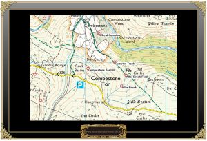
For the geologically minded the tor which consists of several outcrops which display the effects of jointing and the effects of erosion which are all part of the tor formation on Dartmoor. The actual summit of the main outcrop is studded with naturally forming, formed and unforming rock basins one of which its lying on its side at the base of an outcrop, such features were once thought to have been ancient Druidical ceremonial basins. The OS 25 inch map shows that on the central outcrop is a bench mark numbered 1156.6 on the map. According to William Crossing the hill on which the tor sits is: “one of the steepest on the moor,” – p.360, a fact easily appreciated when driving down to Saddle Bridge.
A large tract of the Combestone area is partially enclosed by water of some kind or another. To the west there is the O Brook, to the north east the River Dart, to the east The Aller Brook and to the south the old Holne Moor Leat. Both of these brook names have an ancient lineage stretching back many centuries.The name of the Aller Brook appears in the Domesday Book of 1086 as the Alra which in turn may have mutated from the Anglo Saxon word Alor meaning the alder tree which could imply that alders grew down its banks. The O Brook appears in the cartulary of Buckfast Abbey in 1240 as Ocbroke which may have derived from the Anglo Saxon word ac meaning oak thus giving brook of the oak. Another suggestion is that the ‘o’ is a shortened version of the word ‘Old’ and there can be no doubt that that is the case.
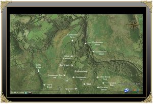
Much of the area around Combestone Tor shows evidence of Bronze Age settlements, and boundary banks known as ‘reaves‘ all of which make up the Dartmeet Parallel System of ancient field systems. Many of these features can be plainly seen on aerial photographs some of which are visible on the aerial plan below.
The ‘Old Men of the moor were certainly busy digging for their tin and just to the east of the tor is the evidence of three openworks, one being the infamous ‘Hangman’s Pit’. Just opposite this pit are the remains of a two roomed tinner’s hut built into a spoil heap, all these features have been dated as medieval or post-medieval. A later site for tin extraction is Wheal Cumston which is located just south of the farm. It is locate within some medieval tin workings and was intermittently worked during the early to mid 19th century. Several features remain including the mine captain’s house, two dressing floors, a wheel pit and a buddles and an adit.
There have also been several notable occurrences which appeared in various local newspapers from the mid 1800s. Here are but a few examples:
On the afternoon of Thursday 10th of June; “The atmosphere became clouded and the mutterings of distant thunder were heard. About sunset the lightening began to play on the horizon, at 9 o’clock the rain fell, and the electrical storm burst directly over our town (Ashburton); the scene was awfully grand , the lightening was a continual vivid stream; the storm lasted about an hour and a half, and was the most severe that has visited us for many years… In the road over Holne Moors, towards two Bridges, is situated a small farm called Compston, rented by Mr. Peter Mann, who, with his wife and family were in the house between 9 and 10 o’clock; the thunder was terrific, and in a moment a crash was heard, and all the inmates were hurled against the walls; the scene cannot be described, the father and mother imagined that some of their family were seriously hurt; Mr. Mann looked out of the window and perceived the thatched roof was on fire; the inmates, who recovered from the astounding effects of the shock, got out of the house, and saved a cask of cider and some wool, but most of the furniture with some other property, with some money in notes, were entirely burnt, the farm belongs to Sir B. P. Wray, Bart., but the loss to Mr. Mann who is not insured is considerable.” – Western Times, June 19th, 1858, p.3.
On the July of 1858 a notice appeared a local newspaper asking for ‘benevolent subscriptions’ which read; “To the benevolent – the furniture, with the house, &c., at Compton Farm, Holne, was burnt down by lightening, during the Thunderstorm, on Thursday night, June 10th, 1858, by which a heavy loss was incurred to the tenant, Peter Mann, and subscriptions in his behalf would be gratefully received by S. Mann” – The Western Times, July 31st, 1858, p.1.
Peter Mann died in 1869 and following his death his wife Elizabeth continued to run the farm until the September of 1877 when it was put up for sale. On September the 14th 1877 a notice appeared offering the sale of Combestone Farm from which a good idea of the livestock and assets on the farm. They consisted of 16 bullocks, 5 horses and colts, 4 pigs, about half an acre of potatoes in the ground, implements in husbandry, cider casks, household furniture an other effects. – The Western Times, September 14th, 1877, p.4.
Later in 1877 Combestone Farm was taken on by the Norrish Family. In the November of 1881 Samuel Hannaford hung himself from a tree with his pony’s halter in the old mining gully known today as ‘Hangman’s Pit‘ whilst in a fit of despair. And according to the many versions of the story one of the Norrish family who were at the time living at Combestone Farm who discovered the body and cut it down. They were noted to have said at the time that he: “couldn’t abide zeein’ sich a gude halter g’wain to waste.” – Hemery, p.537. It has been said that whenever the Norrish family had any kind of business transaction to conduct rather than write a cheque they would bring with them a bag of sovereigns and make the payment in gold pieces – The Villagers of Holne, p.21.
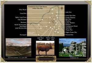
It is also interesting some of the old field names that can be found for Combestone Farm as can be seen above. In particular you can see the two plots where the potatoes were grown as mentioned in the advert of the sale in 1877, these being the Potato Plot and Higher Potato Plot. Clay Newtake is a slightly misleading one as normally the ‘clay’ element refers to land from which clay way dug. However in a Dartmoor context the word has mutated from ‘cleave’ indicating land on a slope or bank. Hard Head and Little hard Head are also ambiguous field names, the element ‘Hard’ normally means ground that is; “land with a barely penetrable surface surface or for some other reason difficult to till.” – Cavill, p.193. But in this context the term may well have some kind of connection to the Wheal Cumston mine as it’s nearby?
Today, the tor is bustling with activity both of a human and animal kind all going about their daily business. Often the tiny car park will be crammed with military Landrovers as some exercise is taking advantage of its height for a communications centre. The area around the tor is also popular with letterboxers and rock climbers as well as picnickers. The animal visitors are usually a herd of mixed Devon cows that migrate up and down the common and these are a splendid example of prime beef animals. The car park also makes an ideal starting point for a walk across to Aune Head which lies a couple of boggy miles away the the south-west. for many years the spot has been the favourite for tourists and in many cases – come the hoards, come the litter’ and this Tor was no exception. In the June of 1929 a letter appeared in the Western Morning News regarding the litter problem on the Moor; “Recently on passing Combestone Tor I was glad to notice that a barrel, on which was painted “please place your rubbish herein,” had been fixed there by the County Council. They had also erected an iron notice board informing the public that the police were authorised to prosecute anyone wilfully disfiguring or damaging the Moor.” How times change today there is no barrel, no sign and the chances of a policeman being at the tor very slim let along prosecuting anyone!
Spooky or What? – On one visit to Combestone Tor I parked up at the parking bay in order to take a bimble over to Skir Hill and as it was about the only dry day of that autumn I sat on the tor having a pre-walk flask of coffee. Here was I happily staring down the valley in a little world of my own when suddenly a small figure darted around the side of the tor. The small figure transpired to be an elderly gent who without an invite plonked himself down next to me and immediately started babbling on. It seemed that he was some paranormal investigator and was looking for Hangman’s Pit. I was then regaled with the sad story of the farmer’s suicide and told how he was going to try and contact the spirit. Apparently this was the man’s first visit to Dartmoor and he couldn’t find the pit, which was a bit of a shame because if he’d carried on a quarter of a mile down the road he would have driven right into it. Having finished my coffee I pointed the ghost-buster in the right direction but just as I was about to leave the old feller nonchalantly said; “You won’t find them, they’ve gone.” “Excuse me, What’s gone,” I asked. “The nails,” he said and then darted off back to his car. I was completely dumbfounded, the only reason I was going up to Skir Hill was to try and re-locate what at one time was said to be the smallest cross on Dartmoor. I never mentioned a word of where I was going or why and the scary thing is that the cross was made of two rusty nails. How could someone who has never been to Dartmoor possibly know about the cross? it’s certainly not in any of the books. More to the point how did he know I was going in search of it? Even more annoying is that he was dead right, I didn’t find them despite an exhaustive search. On the way back I drove past Hangman’s Pit but could see no sign of the enigmatic paranormal investigator.
Not only were the sacred ‘basins’ for Druidical purposes but they may serve as a washing place for the piskies who are said to live in a small combe on the side of the tor. It is said that on still nights you can hear the music from their revels wafting up the slopes to the tor

Cavill, P. 2018. A New Dictionary of English Field Names. Nottingham: The English Place-Name Society.
Crossing, W. 1990. Crossing’s Guide to Dartmoor. Newton Abbot: Peninsula Press.
Gover, J.E.B. et.al. 1992. The Place-Names of Devon. Nottingham: The English Place-Name Society.
Hemery, E. 1980. High Dartmoor. London: Robert Hale.
Phillpotts, E. 1919 Demeter’s Daughter. London: Methuen & Co. Ltd.
Villagers of Holne. 1977. A History of Holne.
 Legendary Dartmoor The many aspects past and present of Dartmoor


Loved the tale!