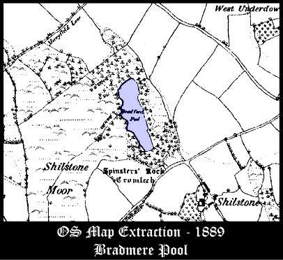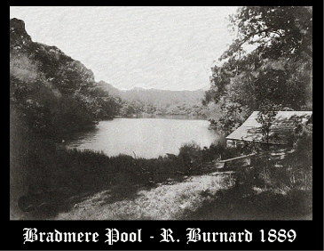
Due east of the small moorland village of Drewsteignton lies Bradmere Pool, a large, tree lined, dark, foreboding place which covers about 3 acres. Today the pool is more commonly known as Bradford Pool but in the past it has been called both Bradmere Pool and Beechmere Pool. It lies on Shilstone Moor, a name which dates back to the Domesday Book when it was Selvestan which derived from Scylfstan meaning ‘shelf stone’. This refers to the prehistoric dolmen known as Spinster’s Rock. As can be seen from the map extract below this lies to the south of the pool and was once thought to have been a Druid’s Temple.

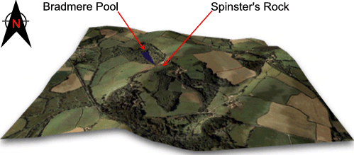
The pool serves as an excellent example of how the early antiquarians read the landscape and its features and the misinterpretations that followed. In 1848 Samuel Rowe, (1985, pp 118 – 121) commented on some notes that a Col. Hamilton Smith made when visiting the pool. Before looking at his ideas it would be as well to consider the topographical location of Bradmere Pool. As can be seen below, the pool lies below a promontory which attains an altitude of around 850ft, a rise of 100ft from the waters.

Ok, so what were Col. Hamilton Smith’s conclusions: “The sheet of water, or dub,” (this word comes from an ancient language used by writers of the old testament called Chaldee, and means to ‘flow’) embracing part of the sacred hill, and probably a sacred grove, having on one side an oblique communication with the water, by a gradual ascent, occurs in other places, particularly in two similar monuments of Celtic origin, among the Savern (sic) Hills and the Vogesian mountains, where altars, sacred inclosures, and consecrated pools of great depth, occur, as here. Forests surround them, as was no doubt the case, also at Shilston. As for the sloping ditch, forming a road, it may have served for the covered coracle, containing the novice in his mystic regeneration, and second birth, to be drawn up from the waters to the mimic Ararat of Gwidd-nau.” So, it looks as if the authoritative colonel is going down the lines of a sacred druidical landscape where mysterious rituals took place. Bearing in mind he probably had seen Spinster’s Rock, it is possible that the picture he imagined was one of Druids and their acolytes running up and down from the dolmen to the pool chanting their spells. However there is more and things become slightly confusing as a Mr Harcourt adds his views: “Worship on high places, imitations or at least memorials of Ararat – was a characteristic feature of the diluvian rites.”
Rowe then notes how Harcourt had: “adduced a number of instances to show, that where natural hills or mountains contiguous to, or peninsulated by water, did not occur, that the memory of the diluvian mountain would be preserved in artificial mounds and pools, such as Col. Smith supposes those at Shilston to have been… The reasons for this he traces to a traditionary recollection of the altar built upon mount Ararat by Noah, and to a supposed injunction of that patriarch to his descendants to construct their altars in such situations as would preserve the memory of that awful catastrophe.” So it appears that the landscape is an artificial, man-made ritual centre used by the ‘Celts’ to somehow remember the great deluge sent by god to punish mankind for his impiety and of how Noah’s ark landed up on mount Ararat? In addition Rowe also draws attention to a local legend which claims that there is: “a passage lined with stones (high enough for a man to walk upright) from this lake to the Teign, near the Logan Stone. This seems to point to a covered way connected probably with the Cromlech (Spinster’s Rock), the ailee couverte of the Brittany dolmens.” In which case not only do we have a druidical temple and a replica of mount Ararat, there is also an underground passage linking them and the Logan Stone that lies two miles away. Please bear in mind that these theories were being applied to landscape features across the length and breadth of Dartmoor during the mid 1800’s. But how did the early antiquarians explain away Christian beliefs coming to a pagan island, and more specifically Dartmoor? Simple, the Phoenician tin traders brought the stories across with them? Which means that the ‘Celtic’ druids of Dartmoor somehow incorporated the story of Noah into their pagan teachings and built monuments to enable them to worship the Christian god along with their pagan deities?

Having now been given the idea of a ritual landscape we turn to what Mr Hamilton Jenkin (2005 pp. 105 -106) has to say about Bradmere Pool: “Of the cassiterite occurrences the most noteworthy was Bradford (or Bradmere) Pool … covering upwards of four acres the site originated as a stream work for alluvial gravels. Stannary records show that dues were being paid here in 1539 … In 1789 the Rev. John Swete describes the Bradford site as a ‘vast hollow excavated through a succession of ages by miners’. The work had previously lain idle for a considerable length of time due to collapse of the drainage adit as a result of which an accumulation of water had overwhelmed the bottoms. In 1783, however, the old adit driven beneath the hill on which the prehistoric dolmen known as the Spinster’s Rock stands, was cleared and at the time of Swete’s visit the excavation was again dry … a mining sett was granted at the northern end of the pool sometime before 1841 … In 1846 working was recommenced by a Bristol company who named the sett Wheal St. Ann … At sometime prior to 1848 the adit referred to by Swete had again become choked and Rowe who visited Bradford in that year found it once again a pool – as it still remains“. Wreford and Williams (1985, pp.41 – 44) consider that the mine closed down because of the Civil War and that it became the subject of a five year litigation claim in 1698, finally re-opening in 1782. Exit the druids and their coracles along with the replica Mount Ararat, what Col. Hamilton Smith saw was the flooded remnants of the old mine. The underground passage that legend says ran from Spinster’s Rock to the logan stone was obviously one of the mine adits.
Bradmere Pool has also been in the past the location for various local leisure activities. Back in the February of 1895 it was reported in a local newspaper that over 200 folk from Chagford were skating on the pool. This is but one instance of people skating on the pool at the end of the 1890s. In the July of 1882 the local rector who owned Bradmere Pool held a Sunday School there, it was reported that over 200 people attended the vent from the surrounding parishes. The children were treated to a sumptuous tea followed by which they took part in a series of rowing boat races up and down the pool.
Bradmere Pool does hide a sad secret, in the August of 1933 a fire at Down Park Farm damaged the farmhouse, stables and two corn ricks. Shortly afterwards another hay rick was set alight at Greystones and all incidents were reported as suspicious. This resulted in a police search for the owner of Venton Farm – Elias Mortimore. He was the brother of the owner of Down Park Farm who lived at Venton with his two other brothers. Tragically his coat, hat and boots were found on the banks of Bradmere Pool and after dragging the waters his body was recovered.
I have recently recieved an email from the editor of ‘The Carp’ fishing magazine who kindly pointed out that as a result of the writings of Denys Watkins-Pitchford (“BB”) in his book “Confessions of a Carp Fisher”, Bradmere Pool has been regarded the birthplace of carp fishing in England.

Hamilton Jenkin, A. K. 2005 Mines of Devon, Landmark Publishing, Ashbourne.
Rowe, S. 1985 A Perambulation of Dartmoor, Devon Books, Exeter.
Wreford, H & Williams, M. 1985 Mysteries in the Devon Landscape, Bossiney Books, St. Teath.
 Legendary Dartmoor The many aspects past and present of Dartmoor

Hi, i am extremely interested in having a walk around this place.
If you could email me with any information on how to do so (wether permission is required and of who to obtained it from)
I would be sincerely grateful.
Bradleyjameshobbs@gmail.com
I live near Bradford Pool and should like to visit it. Is it possible to access it?
see this forum post – https://www.carp.com/topic/12444-bradmerebeechmere/
I used to live in venton and there is a lane there which runs from the hamlet of middle venton to the short cut from whiddon down to Drewsteignton. You have to park either in the lane on the Drewsteignton road or in a lay-by nearby and walk down the lane to a gate on your left and head north to north west and you will find it.