 Legendary Dartmoor The many aspects past and present of Dartmoor

Strange how one thing leads to another, I recently built a page on Staldon stone row which lead on to another on Butterdon stone row and that has now led onto this page about Hobajon’s Cross. Actually it’s a bit misleading to call this a ‘cross’ in the true sense of the word as in all reality we are talking about an incised stone of which there are several to be found on Dartmoor. The history of this ‘cross’ is what in modern terms can be described as a good example of re-cycling, in all probability it started life as a terminal stone of Butterdon Bronze Age stone row. This conclusion is arrived at due to the fact that it stands on the row’s alignment and also because there is reported evidence of several cup marks on the stone which are indicative of the period. Then at some unknown date some god-fearing soul decided to ‘cleanse’ the stone of it’s ‘heathen’ roots by carving a Latin cross upon its western face, again a phenomenon that can be found on many such stones on Dartmoor. Finally, mankind found it necessary to clearly define the limits of their land Hobajon’s Cross were recruited to serve as boundstone.
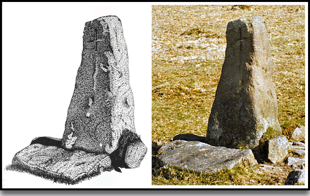
Hobajon’s Cross
The relationship of Hobajon’s Cross to the stone row is explained on the Butterdon stone row page so there is little sense in repeating that here. What I will repeat is how John Ll. W. Page described how the stone became ‘Christianised’ by the addition of the carved cross, he says:
It is at least a pleasant theory which accounts for the presence of the sacred sign on a stone forming part of a heathen alignment. It was carved here, some think, by an early Christian as a protest against the dark mysteries of heathendom, and in the hope of influencing the mind of the barbarous Celt or Saxon, scarcely rescued from the domination of the false creed in favour of the only true religion,” p.254.
Interestingly, today such an act would be described as vandalism and probably carry some kind of judicial sentence and not have been applauded as Mr Page appears to have done. It must be pointed out that another reason for inscribing Christian crosses on stones was to mark ancient inter-moorland track way such as that which ran between the abbey of Buckfast and Plympton priory. The mark would have acted as an indicator that the traveller was following the correct course and to some degree give assurance that there was divine protection from both the earthly and unearthly dangers which lurked on the open moor.
Later on in life the cross enters the realms of confusion as to exactly what form of cross stood at the location thanks to an early map drawn up in the sixteenth century. On the map Hobajon’s Cross is named and depicted as being an actual cross which stood upon a plinth located along the course of a stone row. To further add credence to this idea a gentleman called Spence-Bate found some remains of a cross on Three Barrows which lies some 2 kilometres to the north of Hobajon’s Cross. Presumably, having seen the map’s depiction and then finding the cross remains led him to the idea that Three Barrows was at one time known as Hobajon’s Cross. This idea was also muted by John Chudleigh in 1892 when he remarked: “Another laborious climb over a hill from which Three Barrows with Hobajohn’s (sic) Cross may be seen...”, p.93.
A later idea was that a cross with a plinth (as shown on the map) did stand at the present location but this was lost and replaced with the incised granite pillar. Harry Starkey notes:
“There is at least a suspicion that the cross that used to stand on Three Barrows was formerly known as Hobajohn’s Cross (sic) and stood at a spot nearly a mile to the south of its last known position. This place is now marked by a pillar of granite with a small cross deeply incised upon it.”, p.22.
Eric Hemery further explains that in 1557 the bound commissioners of Brent Moor were tasked with erecting four stone crosses at specific locations along the Brent Moor boundary. Three new crosses were apparently constructed and placed at what is now described as Huntingdon Warren, Western Whittaburrow, Buckland Ford and Three Barrows. He further adds that in his opinion the cross on Three Barrows was an original one placed by the monks of Buckfast to mark their track which ran to Plympton. Therefore when faced with the option of cutting a new cross to be located at Three Burrows the commissioners simply took the one that the monks had sited or as he puts it: “The labour of removing the original Hobajon’s Cross from its socket and loading it on a truck-a-muck (type of Dartmoor sled) for the drag to Three Burrows would have been far less than that of hewing a new cross from moorstone, and in 1861 the mutilated head of a cross, since disappeared, was indeed found on the summit-cairn of the great hill (Three Barrows).”, p.259.
Alternatively, as Butler suggests, it may well have been the case that there was a cross with plinth which later got broken up and the original prehistoric blocking stone, being the largest in the area was simply incised and used as a replacement, p.27. But as Dave Brewer pointed out when discussing the early map’s legend: “this must purely a symbolic representation, and there is no doubt in the author’s mind that what we see today is the original Hobajon’s Cross.”, p.143. This in my mind is a logical explanation as one has to just look at any old map to see a number of misrepresentative icons for landscape features. Incidentally, if you look at John Speed’s map of 1765 it shows just five landmarks for the whole of the moor between South Hessary tor down to South Brent; South Hessary tor, Eyles Burrow, Fox Tor, Peter Cross Tor and Three Burrow Tor. If the location of Hobajon’s Cross was at Three Barrows then why is it depicted as being simply a hill with cairns and not named Hobajon’s Cross when he has gone to the trouble of marking Peter Cross Tor?
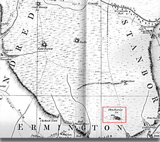
Extracted from ‘A County Map of Devon. The Devon and Cornwall Record Society and The University of Exeter
Then we come to Hobajon’s Cross being utilised as a boundary stone and to see how this came about we must look back to the period between 1782 and 1784. It was at this time that a boundary dispute between Humphrey Savery the owner of Stowford manor which lay in the parish of Harford and Thomas Lane the owner of Langford Leister manor which fell within the parish of Ugborough. In preparation for a forthcoming court case a solicitor named John Andrews was engaged by Savery to survey the Erme Plains and Harford Moor area and draw up a map. At this time there were no boundstones marking the Harford and Ugborough boundaries, instead several prehistoric features were used. One of these being the prehistoric Butterdon stone row which unfortunately Andrews misinterpreted as being a line of actual boundstones. This section of the adjoining bounds became the accepted boundary line which encompassed Hobajon’s Cross as it lay at the northern end, Brewer, pp. 141 -143.
Now for a few vital statistics, the granite slab stands 1.219 metres tall and is 48 centimetres at its widest point, Harrison, p.135. The stone is orientated on a north-west to south-east alignment with the incised cross on its south western face, this cross measures 19 centimetres tall and 14 centimetres wide, Sandles, p.46.
So, as can be seen, there are many uncertainties concerning Hobajon’s Cross; is it a prehistoric blocking stone later used as a cross? Was there originally a more elaborate and conventional cross standing at the location which was later moved to Three barrows? Maybe Three Barrows was the original location for the place name of Hobajon’s Cross? Finally the burning question – who or what was Hobajon? Over the centuries the cross has been documented as being Hobajon, Hobajohn, Hobajones and locally as Hemery notes; Hoppyjon. Suggestions have ranged from a personal name to being connected to some devilish spirit such as a piskie or worse?

Brewer, D. 2002. Dartmoor Boundary Markers. Tiverton: Halsgrove Publishing.
Butler, J. 1993. Dartmoor Atlas of Antiquities – Vol. 4. Exeter: Devon Books.
Chudleigh, J. 1987. An Exploration of Dartmoor’s Antiquities. Pembury: John Pegg Publishing.
Harrison, B. 2001. Dartmoor Stone Crosses. Tiverton: Halsgrove Publishing.
Hemery, E. 19833. High Dartmoor. London: Robert Hale Publishing
Page, J. Ll. W. 1895. An Exploration of Dartmoor. London: Seely and Co. Ltd.
Sandles, T. 1997. A Pilgrimage to Dartmoor’s Crosses. Liverton: Forest Publishing
Starkey, F. H. 1983. Dartmoor Crosses & Some Ancient Tracks. F. H. Starkey Publishing.
One comment
Pingback: Dartmoor from Ivybridge – Panifex Peregrinations