 Legendary Dartmoor The many aspects past and present of Dartmoor

“THE GREAT CENTRAL TRACTWAY – At the meeting of the Devonshire Association at Tavistock, in August 1889, Mr. Robert Burnard afforded some additional and very interesting information about this ancient road. He stated that he had succeeded in tracing it for a distance of seventeen or eighteen miles… He was of the opinion that Mr. R. N. Worth’s hypothesis that this tractway was a continuous road across Dartmoor was correct, and advocated the probability that it formed a portion of the Fosseway“, (Page, 1895, p.294).
The above extract was at the time what today would be called ‘breaking news’ and it caused much excitement amongst the Dartmoor Antiquarians. This theory was to soon become the standard thinking which was soon taken up by numerous other topographical and archaeological writers around the country. Mind you, the concept had been muted some seventy years earlier by three gentlemen named Northmore, Mason and Jones, all keen antiquarians of their time. It was only when Worth and Burnard resurrected the findings of the three earlier men that people began to take notice. But there was some confusion as to the exact date of the trackway, as most of the eminent antiquaries belonged to the Dartmoor Exploration Committee a debate opened up in which various suggestions as to the date of this trackway were offered. Some people favoured the Romano-British origins whilst others went back as far as the Neolithic period and a few suggested a modern date. The purpose of such a feature was also contested with suggestions that it was an ancient trackway, graziers’ boundaries or tin miner’s bounds. Sabine Baring Gould (1998, p.47) however came up with the following theory:
“It is very possible that the long tracklines that extend over hill and vale of Dartmoor indicate tribal boundaries, limits beyond which the cattle of one clan might not feed. Some of the lines, certainly of the age of the Neolithic men of the hut circles may be traced for miles… We cannot be sure of the age of these tracklines unless associated with habitations, as some very similar have been erected in recent times as reeves delimiting mining rights“.
As noted above, by this time various other ‘trackways’ had been discovered and still the debate unenthusiastically continued, it seemed that the antiquarians were more interested in the more prominent prehistoric features of the moor. Then in the early 1900s William Crossing (1990, pp.32 – 33) took the bull by the horns and reiterated Baring Gould’s theory and stated:
” Reave, g. – Banks of earth and stone, sometimes running for a considerable distance, are known by this name on the moor, and are found in all parts of it… Trackline is a name that has been given to them, but not very happily, as it suggests that they were formed to serve the purpose of marking a track, which they certainly were not. There are, however, those who consider that the larger examples were roads and given the name of trackways. I confess that I have never been able to regard them as such, and until it is explained how those who used them contrived to ride through rocks, or immense cairns I am afraid I shall be unable to accept the view that they were designed for purposes of traffic.”
It was this stolid belief of Crossings that the so-called trackway and tracklines were land boundaries and his actual use of the word, ‘reave’ that eventually led to the recognition of such a Dartmoor landscape feature. It did however take another 80 odd years for reaves to be fully acknowledged thanks to work done by Gawne, Somers Cocks and more notably Andrew Fleming.
So, now the idea of a central trackway being trod by Roman soldiers as they wound their way across Dartmoor has been de-bunked and it is recognised that the Dartmoor reaves were land divisions that date back to the Bronze Age. I will now humbly confess, there are two aspects of Dartmoor that bore me rigid, one is the railways and yes you’ve guessed it, the other is reaves. But no section on Ancient Dartmoor would be complete without a page on them so here we are. Andrew Fleming has written a 135 page book on the subject and so there is no way that a single webpage will cover every aspect of reaves, this therefore will be a short introduction. If you would however like to go into greater depth about the reaves then I can do no better than to recommend Fleming’s book which was updated and re-printed in 2007 – see link opposite.
As always let’s start with the definition of a reave which comes from the English Heritage Monument Type Thesaurus:
“A stone wall, often of considerable length, built to divide an area of land. Most occur as part of extensive walled field systems. This is a regional term specific to Dartmoor and should not be used in other parts of the country.“
Firstly, why are they called reaves?
Simply because the word ræw is an old Saxon word which means ‘line’ or ‘row’ and this has mutated to reave which denotes a ‘line’ or ‘row’ of continuous banking, (Clark Hall, 2004, p.277).
When were they constructed?
The majority of the Dartmoor reaves were built during the Middle Bronze Age (approx. 1500BC) although care must be taken when looking at reaves as some of them were built a tinner’s bounds much later on. In many cases it is easy to distinguish the later boundary banks because they are often irregular in plan and ditched, (Butler, 1997, p.72). However, archaeological excavation has revealed that under some of the reaves are the vestiges of what are presumed to be earlier wooden fences which means that the land divisions were there prior to reave building. This would indicate an earlier date for such a feature.
Where do they occur?
Virtually anywhere on Dartmoor although the highest concentration of visible remains are in the southern sector of the moor – see fig. 5 below. It is estimated that roughly 407km of reaves survive in the modern landscape which Butler (p.73) considers is, “not far short of the length originally laid out“. This figure excludes any sections of walls that might have encompassed the various settlements and pounds but is an important point as many reaves are often connected to such features.
What did they look like in the Bronze Age Landscape?
Basically take away today’s vegetation that has grown over the reaves and you are left with what the Bronze Age people saw, low walls or earthen banks. Fleming (p.94), describes that his work has shown that: “some prehistoric inhabitants of Dartmoor lived in very large walled field systems beyond which lay pasture land subdivided into large areas by long reaves. It can be shown that fences and banks were also used as boundaries at this time“.
What do they look like in the landscape of today?
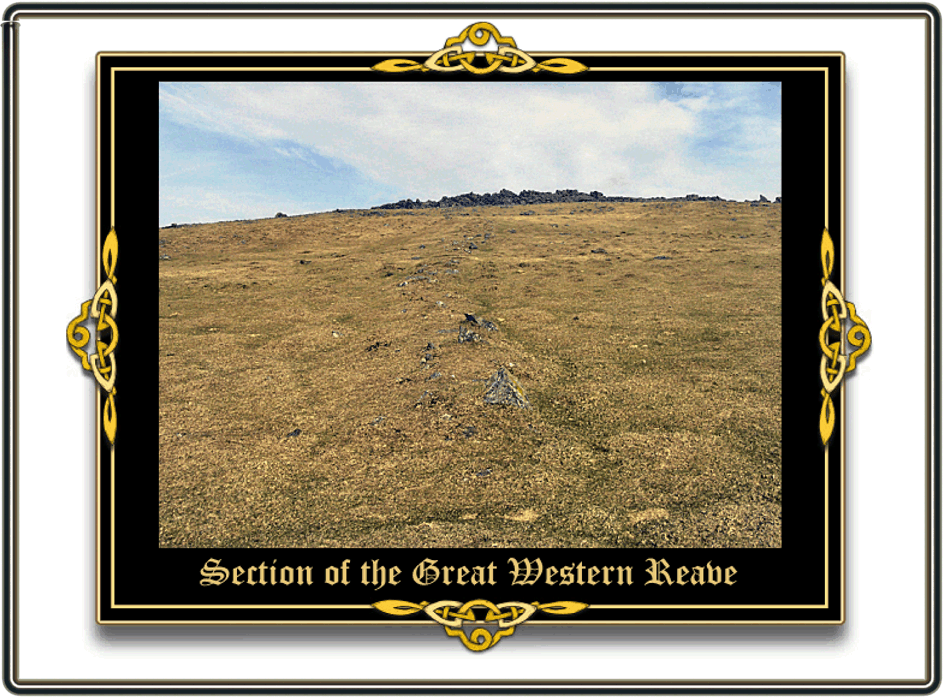
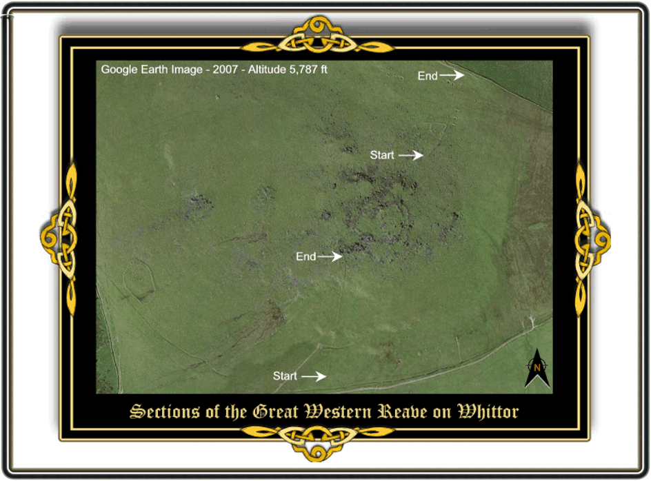
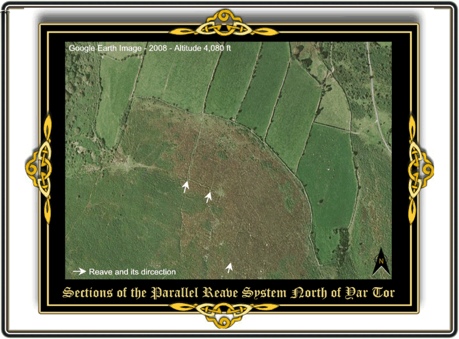
Today reaves can be seen in the landscape as low earthen mounds or low stone walls which normally stand at about 30 – 50cm high and run off in straight lines – see fig. 1 below. Normally the reaves run in parallel lines down the moorland valley sides these in ‘techno-speak’ are often referred to as co-axial systems. The accuracy in which these series of straight lines were laid out is astonishing as in most cases there is only a 1º deviancy, (White, 2000, p.10). Sadly, in many cases many of the stones have been robbed from the reaves to build later enclosure and newtake walls as they provided an easy source of building material. Thanks to the computer it is now quite simple to find and trace many of the Dartmoor reaves by using the excellent aerial photography provided by Google Earth – see fig. 2 below. However, things are quickly changing as the bracken encroaches over the low reaves in some areas, which, depending on when the aerial photograph was taken can obliterate them from view. Since Fleming undertook the reave project the Ordnance Survey have included them on their later maps where they are labelled as, “boundary work”. It is also interesting to note that later field and indeed some parish boundaries adopted the earlier reave land divisions. There are numerous examples of where the line of modern walls are continuations or absorptions of the old reaves – see fig. 4 below for one such example.
What purpose did they serve?
It was during the Bronze Age period that people truly began to settle upon the moor, most of the natural woodland had been cleared to make way for field enclosures that were associated with settlements. Once one talks about settlements, fields etc then there is always a need for boundaries to demarcate them and that is exactly what reaves did – see fig. 5 below. They defined boundaries which ranged from those of single fields to small farmsteads to the larger settlement boundaries and on to the even bigger tribal territories which seem to be based around the valleys. Amongst the various field boundaries were also defined droveways which allowed for the easier movement of livestock from area to area, (Fleming, p.57).


What types of reaves are there?
Co-axial Reaves – see Parallel Reaves
Contour Reaves – Along with cross-ridged reaves contour reaves often occur a fair distance from any settlement and for this reason it is presumed that they encircled and defined the upland boundary of the moor, (Butler, p.74).
Cross-Ridged Reaves – see contour reaves.
Divider Reave – One which separates two adjoining territories.
Parallel Reaves – These define groups of fields that are aligned on a single prevailing axis and are then subdivided by transverse boundaries, (Gerrard, p.52). The land which these reaves enclosed also tended to be the most highly valued land in terms of production, (Fleming, p.56).
Terminal Reaves – These demarcated the top and bottom ends of a parallel field system, (Gerrard, p.52).
Territorial Reaves – This category encompasses some of the other types of reaves but all define tribal territories.
Transverse Reaves – One which lies at right-angles to the axis of the system, (Fleming, p.62)
Watershed Reaves – Often these were laid out along the higher slopes and usually ran parallel with the river below, they were situated just below the hill-crests and probably defined the various valley territories, (Butler, p.73).
There is one tiny aspect of the Dartmoor Reaves that does interest me and that is the following extract from Hemery’s book – High Dartmoor (1987 p.760):
“On the north side of the main pile (Middle Tor SX 669 858) is an extensive prehistoric field-system, including two parallel reaves, again with very large stones, running to the wall of Boldventure Newtake, and another, known as ‘Pigshill Droke’, running southwards“.
It’s nothing to do with the reaves, it is the place-name ‘Pigshill Droke’. The ‘Pigshill’ element is easily explained as this was the name of a farm that appeared in a thirteenth century document but what does the word ‘Droke’ refer to? This is the only example I have come across in a Dartmoor context and the only reference I have been able to find for the word droke is that it was ‘a furrow; a passage, groove’ which may well describe a reave? Another reave that has been christened with an intriguing name is the one that runs northwards of Three Burrows. Here it was clearly associated with the large cairns and in later times became part of the bounds of Brent and Ugborough Moors. Hemery (p.264) explains how in a 1557 survey of the bounds the reave was recorded as being, “a long conger of stones known as Le Rowe Rue“, and so today the name has stuck – Le Rowe Rue. Now clearly this is French and sadly at school I was never allowed to stay in French classes very long before getting exiled to the corridor and the only French I know is, “fermer la porte derrière toi“. But I would hazard a guess at ‘street of the row’? This could well refer to the reave as Crossing, (p.378) explains:
“North of the cairns its character is different. Here it may be likened to a causeway, though it is difficult to see how it could ever have served the purpose of a road, as it has been suggested“.
And that brings us nicely back to where we began because when discussing Le Rowe Rue Crossing was actually referring to the ‘Great Central Reave’ otherwise earlier known as the ‘Great Central Trackway’. Well, I can honestly say for the first time that I’m glad this page is finished – sorry reaves.

Baring-Gould, S. 1998 A Book of Dartmoor, Wildwood House Ltd., London.
Butler, J. 1997 Dartmoor Atlas of Antiquities – Vol. V, Devon Books, Exeter.
Clark Hall, J. R. 2004 A Concise Anglo-Saxon Dictionary, Univ. Toronto Press, London
Crossing, W. 1990 Crossing’s Guide to Dartmoor, Peninsula Press, Newton Abbot.
Gerrard, S. 1997 Landscapes Through Time – Dartmoor, Batsford, London.
Hemery, E. 1987 High Dartmoor, Hale Publishing, London.
Fleming, A. 1988 The Dartmoor Reaves, Batsford, London.
Page, J. Ll. W. 1895 An exploration of Dartmoor, Seeley & Co., London.
White, P. 2000 Ancient Dartmoor, Bossiney Books, Launceston.
Interesting article. But there are a few references to “fig. #” in the text but no obvious figures visible on the webpage (viewed on Internet Explorer 11 and also on Chrome)
Thanks for pointing this out, hopefully now fixed.