 Legendary Dartmoor The many aspects past and present of Dartmoor

“The first part of the way was over East Down, and the road was familiar with us as far as Beetor’s Cross or Bector’s Cross. Rowe and some guide-books call it by the latter name; the ‘natives’ and other guide-book by the former. We would rather incline to the belief that Bector was the original name, and has been corrupted into ‘Beetor’s’. The cross from which it took its name, is or was, in a filed near, but we could not find it.” – We Donkey’s on Dartmoor, M. S. Gibbons, 1886.
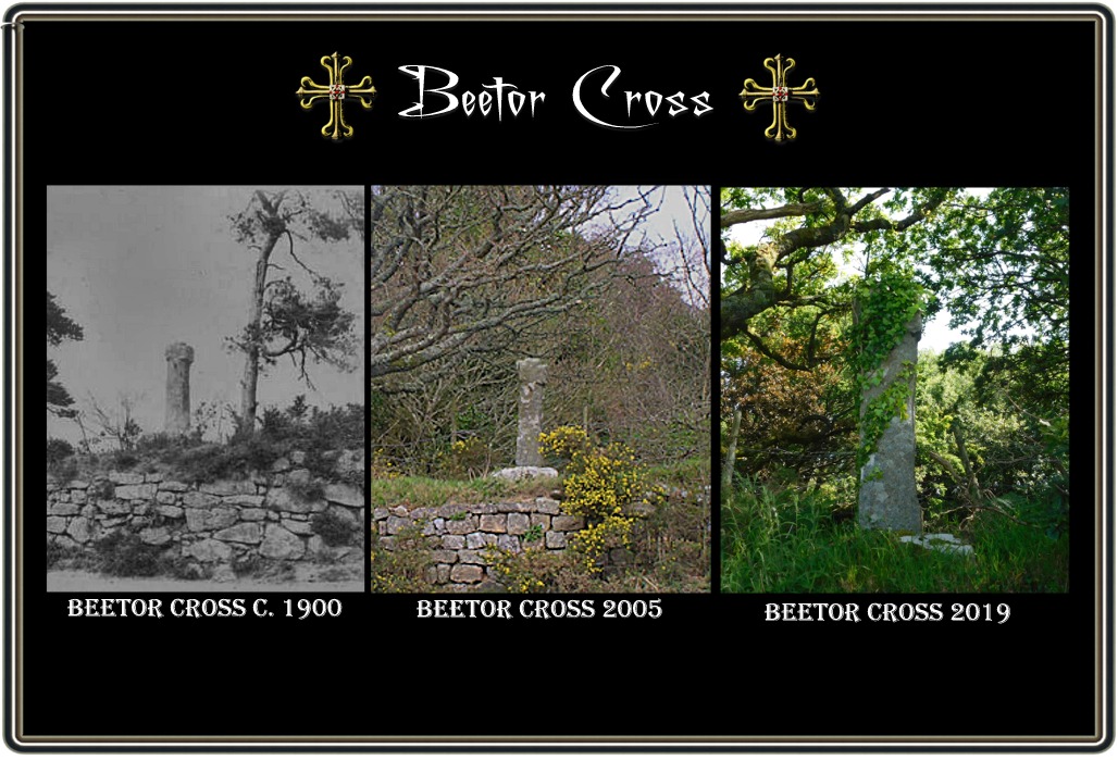
Perched high on the wall at the ‘Watching Place‘ stands Beetor Cross, as the ancient crosses of Dartmoor go this one is none to spectacular and during the summer months when the surrounding foliage is at its best the cross is practically invisible. As can be seen below in the space of 14 years the sad and lonely cross has been slowly cloaked in a green mantle of ivy and the way it’s going it will soon be engulfed.
William Crossing wrote; “In 1857 Mr. Omerod made a drawing of it, when it was acting as a gate-post on Hele Moors. This is probably the same spot on which it stood in Mr. Rowe’s time. as Hele Moors, which are now, and were then, enclosed, are close by, and may very well be described as fields.” Ll. W. Page also notes that the cross was moved about 1871 and was serving as a gatepost on the grounds of ‘Hill House’. I would imagine there was some misunderstanding in the name and he meant ‘Hele’ House, – p.174. Crossing then goes on to add that; “”In 1848 the Rev. Samuel Rowe stated that Beetor Cross was then standing in a field adjoining the spot that bears its name. p.144. Originally he referred to the cross as Bector cross although there is no doubt that the nearby farm of Beetor gave its name to the cross. On the 1840 tithe map (see below) and apportionment for North Bovey there is a field belonging to Beetor (spelt Bittor) Farm which at that time was called ‘Cross Park’ (plot no. 795). On the OS map of today the name has changed to ‘Furze Park’ and is situated some 400 metres west of the ‘Watching Place’. Could this be where Mr. Thornton spotted the old cross or is it just a coincidence that the field name alludes to a cross?
The etymology of the place-name is that the first documented mention of the farm was in 1086 when it appeared in the Domesday Book as Begatora. The first element is thought to have stemmed from the Anglo-Saxon word – byge – which means bend or curve. This could well allude to the circular hill at whose eastern foot the farm is located and upon which was an rocky outcrop. It does seem possible that the logical step of corruption from Begatora would be to Bector as opposed to Beetor? However, I digress, Rowe also adds that tradition suggests that the cross was originally erected to mark the location of a battle between the Saxon invaders and a local army, p.145, which is very unlikely. Much more plausible is the theory that it was erected to guide early travellers going from Exeter to Tavistock on a trans-moor track which has now been replaced by the modern road.

Leaving the debate about a name and from whence the cross came to one side, how did it arrive at its present location? The newspaper report below relates how salvation came in the form of one Mr. Thornton and one Mr. Taylor:
“An interesting relic from the past has been rescued from oblivion and restored to its original position. This is the cross which formerly stood at ‘Watching Place,’ in the parish of North Bovey, at the point of junction of the lane leading from that village with the Moretonhamstead and Princetown road. It is known as Beetor Cross, and tradition says it marked the spot where a battle was fought between the Christian British of the Moor and the Pagan Saxon invaders. Be that as it may, the generally accepted opinion now is that this and many other wayside crosses were erected to serve as landmarks to guide travellers and were fashioned in the form of the symbol of Christianity to save them from mutilation or destruction in an age when such symbols were religiously respected. In later and more practical times, however, these crosses ceased to be treated with veneration, and many of them were removed to serve as gateposts. The Beetor Cross has been similarly utilised for upwards of 25 years on the adjoining property. Early in the year Mr. Thornton brought the cross to the notice of members of the Teign Naturalist Field Club, who unanimously voted a sum of money to cover the cost of restoring it to its proper place. This work was completed by Mr. Thornton with the hearty co-operation of Mr. Taylor, the owner, on Thursday last. A party of 45 members and guests met at Bovey Tracey and drove to the spot to inspect the newly-erected cross. A heavy thunder shower somewhat marred proceedings, but through Mr. Thornton’s forethought and the owner’s hospitality shelter was afforded to the party in the ample kitchen of Beetor Farmhouse…” – Western Morning News, August 28th, 1900.
Finally for those who are interested in size and proportions of the cross and don’t fancy scrambling up that wall, here are the ones I took; “Height = 1.37 m., Span = 40 cm., and Circumference = 1.15 m. The alignment is NW – SE but this has no relevance to its original orientation and the cross can be found at Ordnance Survey grid reference – SX 7131 8419.” – Sandles, p.8.

Crossing, W. 1990. Crossing’s Guide to Dartmoor. Brixham: Quay Publications.
Page, Ll. W. 1895. An Exploration of Dartmoor. London: Seeley & Co. Ltd.
Rowe,S. 1985. A Perambulation of Dartmoor. Exeter: Devon Books.
Sandles, T. 1997. A Pilgrimage to Dartmoor Crosses. Liverton: Forest Publishing.