 Legendary Dartmoor The many aspects past and present of Dartmoor

There is one place on Dartmoor that when in company and responding to the question: ‘where have you been today‘ will always get a snigger, namely: ‘up the Deadman’s Bottom‘. This by no means infers that you have both homosexual and necrophilic tendencies but simply that you have been walking up a very small valley on southern Dartmoor. In all reality and joking apart, the actual place-name hides a fascinating story dating back to prehistoric times. But first to the interpret the name, the second element is the easiest to explain, in Dartmoor terms a ‘bottom‘ can be best described as being a deep valley that is not of the much larger cleave proportions, (Hemery, 1983, p.26). Having said that I would not describe Deadman’s Bottom as being a deep valley, a shallow valley yes but never mind time and tradition has dictated that it is a bottom. The ‘Deadman’s‘ element comes from the fact that roughly 200 years ago the corpse of a man was discovered near the source of the small stream that flows down the valley, (Hemery, 1983, p,197). Crossing, (1990, p.408) elaborates on the story a little more:
‘We have already noticed the occurrence in two localities of the story of land having claimed by a parish on the ground of having given burial to a stranger found dead within the bounds of another (parish) which had refused to do so. The story is also met with in this part of the moor, and though probably having no more truth in it than the others, at least points to some encroachment or altering of boundaries here. The man was found, so the tale runs, lying on the moor at the head of a combe… The combe, down which trickles a small feeder of the Langcombe Brook, bears the name of Deadman’s Bottom.’
This then literally gives us the indicator that it’s the ‘deep valley where a dead man was found’. The ironic thing about this place-name is that although it describes an event which occurred a couple of hundred years ago it could equally refer to events that took place several thousand years ago. The map below shows why:
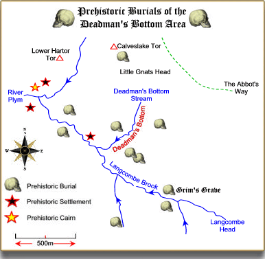
As can be observed, there are 11 known kistvaens in a radius of roughly 1 kilometre of Deadman’s Bottom so clearly the corpse found in the 1800s was by no means the first in the area. This phenomenon may well suggest that to early man there was something special about the valleys of the Langcombe Brook and Deadman’s Bottom. It is easier to appreciate the locations of these burial sites from an 3D aerial map as it clearly shows that the majority of these graves were situated on the valley slopes.
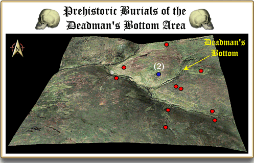
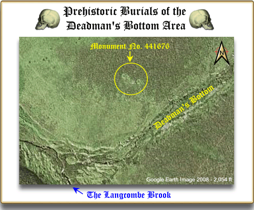
It is also not hard to see that the valley of Deadman’s slices through the cluster of burial sites and just on the western flank above the bottom is a structure (the blue dot on the above map) which may explain why. The actual monument consists today of three to four embanked circles with two associated kists, there is also evidence of a section of curving boundary bank which runs downhill, (Butler, 1994, p.148). If you look at the English Heritage Pastscape record for the site, namely monument no. 441676, they describe it as a Bronze Age hut circle – see the record HERE. This monument is highly visible from an aerial photograph as can be seen from the photograph below:
Having described the monument as a hut circle with an annexe they then go on to observe that: ‘There is no obvious entrance‘. So in which case what is the use of a Bronze Age hut without an entrance, how would its occupants get in and out? Could this mean that the monument was not a hut circle but was used for something else? R. H. Worth and the Dartmoor Barrow Committee examined the monument in the early 1900s and discovered that the two circles were in fact paved and small amounts of charcoal we lodged in the gaps between the paving slabs. The subsoil below the paving proved to be of a light redbrick colour which suggested that some pretty fierce fires had been lit on it. The two kists were also ‘examined’ and the one nearest Deadman’s Bottom yielded up numerous fragments of decorated pot, an European Bell Beaker which was 18cm high and three barbed and tanged flint arrowheads. These finding led Worth to the conclusion that this site acted as a series of cremation pits or if you like the same as a modern day crematorium. The bodies would have been brought here and then cremated, their ashes would have then been placed in beakers and buried in the surrounding kists. Pettit, (1974, p.122) also notes that: ‘Their rather central position in the Langcombe group, and the fact that five kists are visible from them, may be of significance‘.
So, there we have it, a small valley situated in a prehistoric land of the dead which may have well served as the local ‘crematorium’ for the nearby settlements. Could it be that Monument 441676 also shows evidence of some kind of change in belief and ritual? Was the fact that the cremation area was later paved over as an act of closure, the paving slabs acting as a seal over the old practices? Is there any significance that later burials were placed at the site? In later years was Deadman’s Bottom the subject of a parish boundary dispute which as the result of a fatality gave extra lands to one parish? So, many questions for such a remote and proportionally small tract of Dartmoor with equally as small number of answers.
Reference.
Butler, J. 1994. Dartmoor Atlas of Antiquities – Vol. III. Tiverton: Devon Books.
Crossing, W. 1990. Crossing’s Guide to Dartmoor. Newton Abbot: Peninsula Press.
Hemery, E. 1983. High Dartmoor. London: Hale Publishing.
Pettit, P. 1974. Prehistoric Dartmoor. Newton Abbot: David and Charles.