 Legendary Dartmoor The many aspects past and present of Dartmoor

“Ascending through the farmyard, we emerge on a marshy slope which conducts us to the breezy height of Bair Dwon, a long green tableland… Masses of rock upstart from the turf at intervals, the most conspicuous being known as Bair Down, Lidford and Devils Tors.“. – J. Ll. W. Page, p.156.
Beardown, here we have one name which refers to several landscape features, there is; Beardown, Beardown Bridge, Beardown Brook, Beardown Farm, Beardown Hill, Beardown Man, Beardown Newtake, Beardown Tors, and Beardown Warren. All these place names consist of two or three elements, the second – ‘Dun‘ simply refers to an Old English word for down or moor. As to the first element, in all probability it refers to beara’ as in the Old English word for a wood. What it definitely does not refer to is Bear as in the animal. There was some suggestion in the early 1880s that Beardown got its name from the fact that it was here where the last living bear on Dartmoor was killed which is highly unlikely. Where three elements occur then the third element simply refers to a landscape feature i.e. a brook, a farm, a hill etc.

The high point of Beardown Hill sits at 470 metres and then its lowest point drops down to 350 metres and gradually descends from moorland to cultivated enclosures.
The earliest evidence of human occupation on Beardown Hill is a small Bronze Age settlement located on its lower eastern flank. Today there are signs of at least 8 hut circles and enclosure walls, 4 of which have visible doorways and 1 has a circular drainage ditch.
What is now Beardown Farm was once in the ownership of the Rev. E. A. Bray who had a fascination with the Druids and had the notion to turn his lands into a Druidical landscape. Firstly the farm’s name was changed to ‘Bardmont’ and Beardown Hill became the ‘Hill of Bards’. Both associations stem from the fact that he considered his lands and the nearby Wistman’s Wood as at one time being sacred to the Druids. He also named some landscape features with odd mythical names such as; the ‘Isle of Mona’ which is a small natural ‘island’ in the river Cowsic, in similar vein there is another small island he called the ‘Isle of Vectis’. Near to the ‘Isle of Mona’ is a small grotto which he named ‘Merlin’s cave’. Not being satisfied with names he decided to leave his mark literally in stone, at various points on the river Cowsic he found 21 boulders onto which he inscribed various dedications to his favourite Pagan gods and poets. All of which can be found on the link above.
Associated with the farm was what probably started off as a sporting warren but later probably became a commercial one. Beardown rabbit warren is first documented in a Duchy lease of 1808 which was around the time when it was established. The warren extended over 3.8 hectares and in all contains 50 buries of which 49 are enclosed by stone walls. In the north-east corner of the warren was a storage shed where nets, traps etc. were kept. It is assumed that the warren was a commercial one supplying rabbits to Princetown Prison and other local businesses as well as the city of Plymouth.
|
Beardown Hill |
Beardown Hill |


Beardown Tors belongs to an elite group of Dartmoor’s tors as it is just one of several whose name is expressed as a multiple group of outcrops, i.e. ‘Tors’ as opposed to a single ‘Tor’. Some others being Belstone Tors, Hayne Down Tors, and Sourton Tors. The tor group consists of three piles of which the largest that Hemery calls Beardown Tor, p.401 is the most northerly. Although it’s the biggest it certainly is not the highest as is a good few metres lower than the rest. This tor sits at 507 metres whilst the middle tor comes in at 511 metres with the southern tor being the highest at 513 metres. Hemery also descries a small shelter on this tor made from a large slab leant against the rock face and a small wall enclosing it, p.402. There is a fairly large clitter field to the south of the tor which is known as the ‘Grey Wethers’, Brown, p.13., not to be confused with the more famous Grey Wethers stone circles further to the north-east.
Just to cause some confusion, when describing the tors William Crossing suggests that in fact there are four piles in the Beardown Tors group. Presumably he is defining the small pile to the south of the southernmost tor in the group? If however one is describing the actual Beardown itself the in theory a fifth tor must be includeD and that is Lydford Tor which sits to the north-north-west of the main pile.
Over the centuries this northern pile must have been witness to some pitiful sites as the deceased moorfolk were carried along the Lych Way which processes just to the north of the tor on their way to Lydford for burial.
Once again prehistoric man settled this part of Beardown possibly as early as 10,000 years ago. To the east of the tors is evidence of this Bronze Age enclosed settlement which consists of 7 hut circles, 2 of which have visible doorways. Some of the huts are located within the walled enclosure with others either linked to or abutting the walls. Just to the north of this settlement a perforated pebble was found in 1967 which it is thought to have been a macehead dating back to Mesolithic times? Just to the north of the northern tor are the remains of a Bronze Age burial cairn and kist which sits on a north- south alignment. Although not insitu the coverstone lies nearby to the north west.
Somewhere between medieval and post-medieval times the Dartmoor tinner’s were hard at work just to the north of the northern tor. Today the scars of some stream works can clearly be seen on aerial maps as they run down to the West Dart river. These workings cover about one hectare in extent and also contain a small tinner’s hut.
One tale that relates to the Dartmoor pony and its strength and agility comes from the early 1800s and took place somewhere in the area of the tors. Some men attempting to catch a pony which had been singled out from the herd. Immediately it took off into some rocks and was chased by a man who chased up the hillside in order to secure it. In order to evade capture the pony supposedly leap clean over the rider who was mounted on his horse and made good its escape.
As can be seen from the Ordnance Survey map the modern boundary of the Merrivale Danger Area neatly dissects the Beardown Tors from Lydford Tor – a point worth remembering should you wish to visit the area. The military have also left their mark on the middle of the tors in the form of a warning flagpole. There is also a lookout post on the northern side of the southern tor.
|
Beardown Tors |
Beardown Tors |


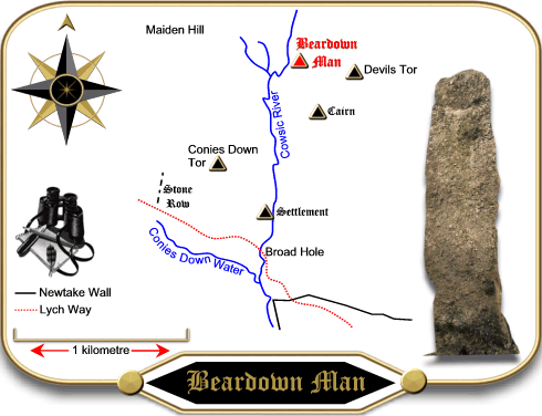
The final landscape feature sits a good two kilometres from the northern end of Beardown plain and that is the ancient Beardown Man, a Bronze Age menhir which sits near Cowsic Head. It always seems a bit strange to attach Beardown to its name as it sits well outside the Beardown enclosure?
So there you have the Beardowns, Druids, sacred islands, prehistoric settlements, an old rabbit warren, several tors, leaping ponies etc. who could ask for more?

Brown, M. 1999. Dartmoor Field Guides – Vol. 29. Plymouth: Dartmoor Press.
Hemery, E. 1983. High Dartmoor. London: Hale Publishing.
Page, J. Ll. W. 1895. An Exploration of Dartmoor. London: Seeley & Co.