 Legendary Dartmoor The many aspects past and present of Dartmoor

If you fancy a stroll over the Christmas break then here is a suggestion. Depending on how much festive fare you have partaken in can determine which way around you go. Should you want the more energetic route then simply go anticlockwise if not then go clockwise which is slightly gentler. Where better a destination for a Christmas walk than Snowdon, not the Welsh one but the Dartmoor one.
Santa on Snowdon – A short walk with breathtaking views, numerous prehistoric monuments, glimpses of Dartmoor’s industrial past and a couple of legends thrown in for good measure, what more could anyone ask for?
Park in the obvious car parking spaces just up the lane on the left-hand side, under no circumstances go past the drive into Hayford Hall – see later on this page. Then follow the stony track until you reach Lud Gate (also known as Lyd Gate) which is obvious when you get there.
The first part of the walk follows the Lud Gate – Huntingdon track which was the main artery into Huntingdon Warren. Along the track you will see a series of set stones whose purpose was to mark the route in inclement weather conditions. About 900 metres along the track it intersects with a prehistoric boundary reave known as le Rowe Rew. The total length of this reave is around 1,900 metres as it runs in a north-west – south-east direction from Puper’s Rock to Water Oak Corner.
Here at the junction sits the tallest of the guide stones which according to William Crossing was known as Kit’s Stone or more locally called by the Huntingdon Warreners the Little Man.
From the intersection of the reave and track the route now heads for about 450 metres in a north westerly direction uphill to Puper’s Hill, following le Row Rew as it goes. Here are three rock piles; Outer Pupers, Pupers Rock and Inner Pupers. The name ‘Pupers’ derives from the fact that nearby were/are some upright stones which are meant to be some people who danced and played their pipes on the Sabbath and as punishment got turned to stone, these became known as ‘The Pipers‘. The word pipers then became mutated and has now ended up as ‘Pupers’.
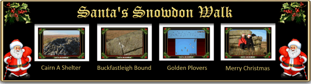
On the summit of the hill squats Puper’s Rock which although being a natural outcrop is thought to have been used as a tor cairn by the Bronze Age moor folk. A fact strongly suggested as the rock is incorporated into the le Row Rew reave. Not only did this rock pile hold some significance to the early prehistoric people but at some point in the recent past to a more modern person. There is inscribed, though barely visible a christogram showing the letters I H S (Iesus Hominum Salvator – Jesus Saviour of Mankind) and a small cross above the letter H which are located on the south western face of the rock, sandwiched between the capstone and base stone. This may well be a memorial to somebody who once favoured this picturesque spot or even possibly somebody declaring their faith. It could even have been an attempt to sanctify what was once a place of Pagan religious importance?
Just over 100 metres to the NNW of Puper’s Rock is the small outcrop known as Inner Pupers and some 270 metres east(ish) of Puper’s Rock sits Outer Pupers. One may wonder why logically speaking Outer Pupers should not be located on the cultivated east side and Inner Pupers on the moorland west side. After all we would say that we went for a walk into the moor not out of the moor if you catch my drift. The reason for this is that on Dartmoor the ‘In-Country‘ or ‘In-Ground‘ always refers to the cultivated lands below the moor and the ‘Out-Country‘ is the land furthest from the moor’s edge. So in terms of Dartmoor logic they both are correctly named. On the small eastern pile can be seen an inscribed ‘B’ which denotes that it is one of the markers on the Buckfastleigh bounds. Apparently when Buckfastleigh were beating the bounds in 1902 they could not find this marker. Well no surprise because we missed it on the first visit and it was only when the sun was at a higher angle that the letter miraculously appeared.
All around the hilltop are the distinctive signs that at one time the stone cutters had been at work as indicated by the small quarry pits and their tool marks on the remaining rocks.
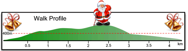
From the Pupers the next leg of the route heads just west of north for about 1 kilometre to the summit of Snowdon. Roughly 500 metres along the way lies ample evidence of tinning activity in the form of a mining beam known as Gibby’s Beam. Exactly who Gibby was is a mystery but they must have been a fairly influential person as to the north-east is Gibby’s Combe, Gibby’s Combe Wood, and Gibby’s Combe Tor also named after them. On the western side of the Western Wellabrook are further tin workings knows as T Gert and Wellabrook Gert. Just opposite Gibby’s beam on the east side of the route is a small hollow in which sits a scattered rock field known as Black Bush.
The summit of Snowdon sits at the lofty altitude of 495 metres which makes it the second highest point on the Southern Moor. Incidentally should anyone wish to visit the highest point on the southern moor then Ryder’s Hill (515 metres) lies just about 1 soggy kilometre away to the north-west. The reason this walk does not extend to Ryder’s is that the very name does not sound very Christmassy compared with Snowdon.
Talking of which, why on earth is the hill called Snowdon when it’s more famous and loftier counterpart sits miles away in Wales? Probably because they both have one thing in common – snow. The Place-Name Society states that the first recorded example of the name occurred in the Devon Assize Rolls of 1238 when it appeared as Snoudon. The two elements probably came from the old word snãw meaning snow and dun meaning hill thus giving the ‘hill of snow’. This then may well suggest that the hill has been known for deep accumulations of snow or the fact that the snows laid here much later then elsewhere.
Again the summit of Snowdon was a place of significance to the Bronze Age people or it was here they sited four ritual cairns. The question as to why can easily be answered by looking at the wide-ranging views and visibility within the surrounding landscape the hill commands. The southern most and largest of the four cairns (B) has a diameter of 23.3 metres and indignantly displays the signs of mutilation in the form of a modern marker cairn. Just north of this lies the second cairn (A) which with a diameter of 16.5 metres is the second largest, again showing signs of mutilation in the form of a round shelter. Again just to the north of there is the third cairn which is very slightly smaller with a diameter of 16 metres. The forth and smallest cairn lies virtually buried in the hillside and has a diameter of 8 metres.
I think it is fair to say that the summit area of Snowdon is not the driest of places on Dartmoor and this is thanks to the work of the peat cutters of old. Over time they virtually stripped the top layer of peat from the hill which has resulted in the present-day conditions.
From Snowdon’s summit the next port of call will be the top of a mining gully known as Snowdon Hole. This was the deepest of the surface workings belonging to the Huntingdon Tin Mine. This section of the mining operation stretched from here westwards to join up with Gibby’s Beam. The Huntingdon Mine was worked on and off between the years of 1851 and 1868 when it finally wound up operations.
It is here that the waters of the Snowdon Brook issue forth as it makes it’s short downhill journey to join the River Mardle.
As with any route suggestion it usually is a good idea to actually walk the whole thing just to make sure everything is in order. So on what promised to be a fine but cold day Louise, Rhys and myself set sail for Dartmoor and Lud Gate. It was so long since I had been there and the old memory cells are short these days that the trusty, old, battered OS map was needed. We arrived on Dartmoor to find clear blue skies, visibility for miles and a bracing nip in the air – perfect. But, and a big but, if you want to see a case of bad karma read on.
I have just said that the old memory is not what it once was but deep down in the dark and dusty recesses of my mind library I pictured Lud Gate with some parking spaces just below it. So having reached the end of the road at Hayford Hall we were met with a sign demanding that it was only authorised access beyond that point. Yeah right, I hadn’t driven 150 odd miles to be told that crap so up the stony, narrow, pot-holed lane went. Imagine the surprise when we reached Lud gate to find no parking spaces or anywhere to turn around accept up somebody’s drive. OK, it was narrow but up the drive we went turned around and were then met with the house owner. Obviously he does not get any visitors as he soon came out to ask what we were doing. Our predicament was explained, he was satisfied and he even kindly advised us that it would be cold up on Snowdon and to make sure we had enough warm clothing – ah bless.
So back down the stony, narrow, pot-holed lane we drove. The car had only bumped along for about 100 metres when the tyre pressure monitor suddenly lit up like a Christmas tree and indicated that there was something amiss with the front near side tyre. On inspection we found a 5 centimetre gash in the tyre wall and air hissing out at a rate of knots. After what seemed an eternity we limped back down to the proper car parking space by which time the tyre was as flat as the proverbial witches tit. Now the embuggerance with the modern-day performance car is that they no longer come with a spare tyre and the gunk would not repair this gash.
Time to call International Rescue, except nobody had any phone signal OK, the next step was to gingerly limp back to the nearest sign of civilisation which in this case was the village of Scorriton. Having reached there we parked up in the car park of the Tradesman’s Arms pub. Luckily there was now a signal and after a brief conversation International One was dispatched with an arrival time of between 1 and 2 hours. Incidentally at this point in the proceedings it was 11.15am and freezing cold. Imagine being stuck outside a pub which was not due to open for another three quarters of an hour. But, seeing our plight the very kind landlord of the Tradesman’s Arm open up and let us in.
Eventually a very nice man, and he was an extremely very nice man, from the RAC rocked up, saw the predicament and calmly explained the options. Bearing in mind that the tyre had to be replaced at an ATS depot and the nearest was in Newton Abbot. So he could either put some air into the tyre and hope that was enough to get to Newton Abbot or he could fix on a space-saver tyre and follow us to the depot. It seemed prudent to opt for the second option and so before long we were following International One to Newton Abbot. As it turned out not only did the punctured tyre need replacing but they also discovered that the front off-side tyre was almost illegal – lucky, well sort of. At this point I would like to sincerely offer our thanks to both the landlord of the Tradesman’s Arms and the man from International Rescue for kindest above and beyond the call of duty.
By the time the car was once again tyre worthy it was far too late to go back to Lud Gate and the consensus of opinion was it might be a good idea to drive to Princetown, visit the Plume of feathers and drown our sorrows. That is exactly what we did, so there you have it bad Karma at its best, if I had heeded the sign we would never have got the puncture and completed the walk. So, plan B, return again, park in the designated parking spot and hopefully reach Snowdon.
OK, plan B, same place, same time, only on this occasion we parked the car in the designated zone like all good boys should. Once more it was a bright, crisp morning with pink skies to greet the rising sun as Rhys and myself wandered down the lane leading to Lud Gate. The first kilometre is a haul as the Huntingdon track ascends Puper’s Hill. About halfway up there was an obvious cluster of rocks on the right of the track and it was here that Rhys found an old Ordnance Surveyors bench mark along with the cut niche into which the theodolite would have been placed.

Not far from here was a small upright granite pillar which I assume was Kit’s Man alias the Little Man? Just beyond that point the le Row Rewe came down from the top of Pupers Hill and crossed over the track. Here things got a bit confusing as true to form I had no map and instead of walking up to Pupers Rock we carried on across Hickaton Hill. However, the mistake soon became clear and so we traversed back up Puper’s Hill to the rock. It did not take long to find the IHS inscription and after admiring the view we trundled over to Outer Pupers to see what we could see – basically more wide ranging vistas across to Hunting Hill and Warren. There seems to be a recent trend amongst walkers to include your boots when taking a landscape photograph, I suppose the ‘selfie’ is well established and now it’s the ‘bootsie’ – don’t ask me why either. So as can be seen I thought I’d give it a try and for the life of me I can’t see the point apart from nearly breaking your back taking the shot. There are several excellent examples of the stone cutter’s work around Pupers Rock, many showing the tare and feather holes and rock split. I often wonder what was said when all the hard work of drilling the holes, whacking in the tare and feathers only to find that the rock is splits wrongly?

From Pupers Rock it is only a short distance to Outer Pupers which in the Dartmoor scheme of things was no big deal saving the excellent views across the western moor. Inner Pupers is again of the same stamp but again provides some wide ranging panoramas. It really is difficult to imagine which rocks were the poor unfortunate folk turned to stone as there are no upright, humanoid rocks anywhere to be seen?

The half mile stretch between Pupers Rock and Snowdon again provides excellent vistas along it’s length. To the west Redlake Tip erupts volcano-like form the surrounding moor and good views of Gibby’s Beam and Huntingdon Hill can also be seen. The ground underfoot began to become wetter, with peat pools and small hags and therefore it was no surprise when on several occasions Jack Snipe zig-zagged out of the reeds. Their unmistakable ‘chick, chick flight song was the last fleeting sign of their presence.
On reaching Snowdon the pimple-like cairn B which had been visible on the uphill climb suddenly grew in stature to a huge pile of rocks. Not far away was cairn A with its well constructed shelter and another not so well constructed shelter on tits top side. As with all such cairn shelters on the moor there is no evidence as to their ages or who built them. Was this particular shelter originally built by the stone and peat cutters or maybe latter day walkers looking for some overnight accommodation? As mentioned earlier there is definite evidence of industrial activity on Snowdon in the form of denuded surfaces where the peat had been extracted and various partially split rocks. As with the whole of this ridgeline there are some breathtaking views in every conceivable direction.

From Snowdon there are two possible ways back to Lud Gate, either descend the hill in a south easterly direction or retrace your steps, we opted for the latter. Having got back to Outer Pupers the noonday sun had kindly lit up and inscribed B on one of the rocks which we missed on the way out. This was the bound point on the Buckfastleigh bounds. Having returned to Pupers Rock we then took a gentle stroll downhill and followed the le Rowe Rewe reave back to the Lud Gate to Huntingdon track. Halfway down Pupers Hill we were treated to the spectacle of a large flock of Golden Plover wheeling around in the sky. Their gold coloured feathers giving them the appearance of tiny gold flakes as the sun caught them in its rays. As far as I can remember this was the largest flock I had ever seen on Dartmoor and a joy to behold.
So, after the previous attempt of getting up to Snowdon we finally managed it and without a tyre puncture. I cannot stress enough that should anyone want to do this walk make sure you use the allotted parking space.
This article refers to le Rowe Rew as “around 1,900 metres as it runs in a north-west – south-east direction from Puper’s Rock to Water Oak Corner.”
Crossing’s Guide To Dartmoor places Le Rowe Rew as being near Three Barrows, saying that “This reave, which is referred to in the sixteenth century as ‘a long conger of stones called Le Rowe Rew,’ comes up the hill S. from above East Glaze Head, where it presents the usual appearance of a bank of turf.”
Is this a case of confusion between two locations, two locations with one name, a mistaken identification, new information coming to light, or what?