 Legendary Dartmoor The many aspects past and present of Dartmoor

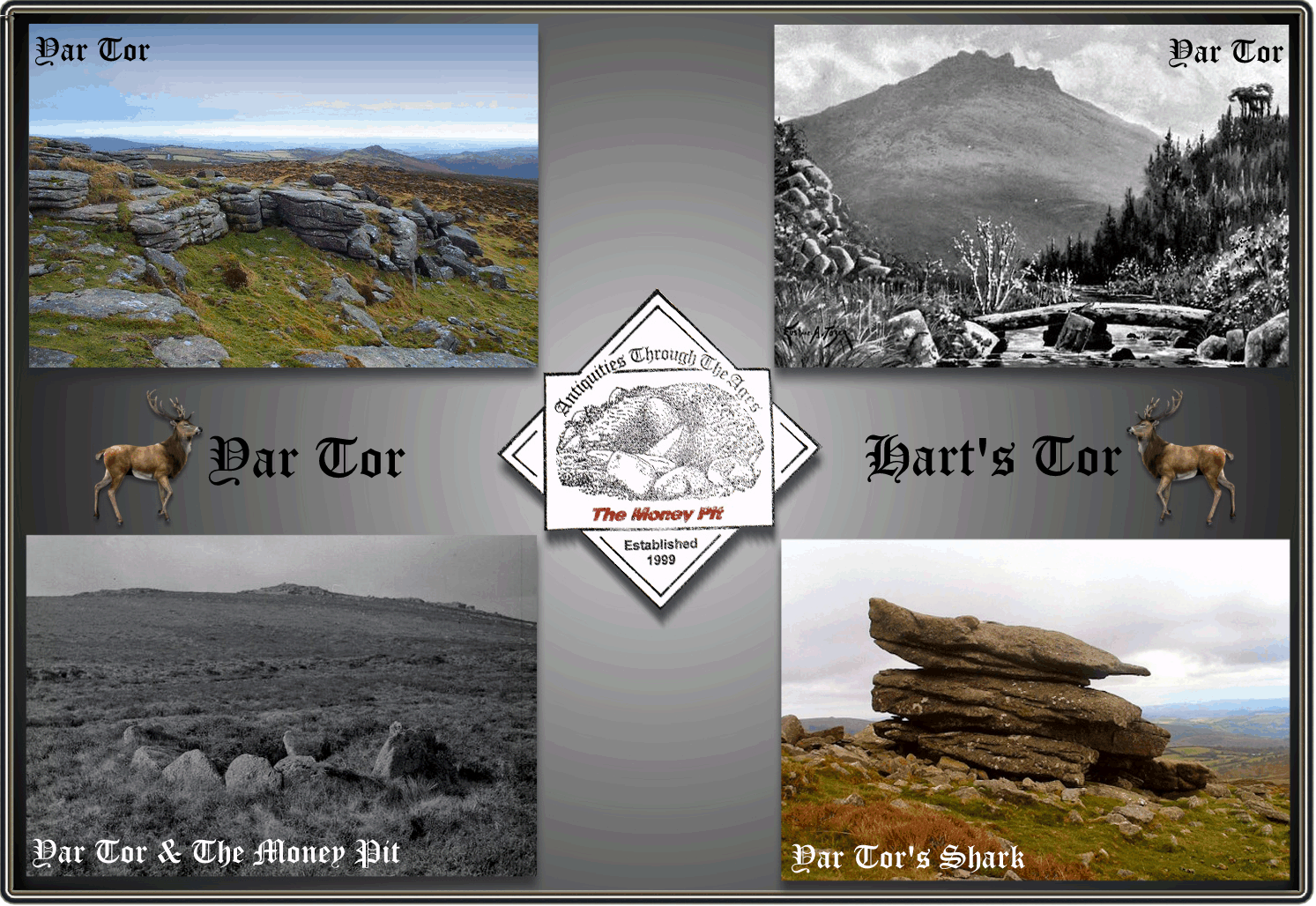
“Few of the Dartmoor heights are so situated as to show themselves to such advantage. On the right, a spur well clothed in dark fir plantations comes down from Brimpts; and on the left is a clitter of bold granite rocks. The time to visit this is certainly the evening, when Yar Tor is bathed in golden glory, and the woods are steeped in royal purple.” Baring Gould p.199.
Amazingly Yar Tor sits on the northern half of Yartor down which is neatly carved in two by what is now a busy road. On the north Yar Tor is bounded by the old Babeny enclosures, to the east by a road, part of which is known as the Miller’s Mile. To the south snakes the busy Ashburton to Princetown road and to the west flows the East Dart river.
I think it’s fair to say that the tor does not sit on any of the popular walking routes but as it is not far from the road tends to see a lot of tourists out for a drive. Due to the tor’s summit sitting at a respectable 416 metres there are some excellent views to be seen in every direction. It may well be that due to its imposing and prominent position that mankind has seen fit to live, worship and bury its dead both on and in the shadow of the tor since prehistoric times.
At the normal risk of boring folk I will, as usual, begin with the actual place-name that applies both to the tor and down. Once again, what the modern name suggests in nothing like what it originally meant. First documented in the Court Rolls of 1377 the name appeared as; “Hurtetorre in vasto Spychewyk,” in a Duchy of Cornwall document of 1385 the down was “Hurtetore Doune.” So the common denominator being Hurtetorre and it is to this we need to look to find the etymology of the tor and down. In this case it is the Old English words Heorot or Heort which mean ‘hart’ or ‘stag’, Clarke Hall, p.179., thus we have’ tor of the hart’. Eventually over centuries Hurtetorre mutated to Yar Tor both implying that both tor and down were a favoured habitat of deer.
A look at any map will show that during the Bronze Age the down and tor were home to quite a thriving community. All around the lower slopes of the tor is the evidence of numerous hut circles and settlements. The remnants of their field systems can be seen on the aerial map below along with the reave systems. On the higher ground these early moor dwellers were erecting their ritual monuments in the form of a stone row and burying their dead in kistvaens along with some impressive cairns. There are a couple of these features which for varying reasons are of particular interest. The first being what is prosaically called ‘The Money Pit’, this being a kerbed cairn and with kist that has a local legend attached to it. One writer of the 1800s described the Money Pit as: “perhaps the most remarkable on the moor is the solitary one on the down between Quarnell (Corndon Tor) and Yar Tors. The scene from this kistvaen is one of the finest on Dartmoor. In front is the steep cone of Mil Tor, ‘the yellow hill’ beyond which is seen the opposite side of the valley, covered with granite rocks, and rising to a great height above the river...,” King, pp. 20 – 21. Although hard to identify the stone row has forty of its stones existing and there are suggestions that this was a triple stone row. According to Mr. R. Worth in 1894 there were a number of stones forming the triple stone row but by 1897 many had been removed and recycled for road construction, presumably leaving just the single row of today.
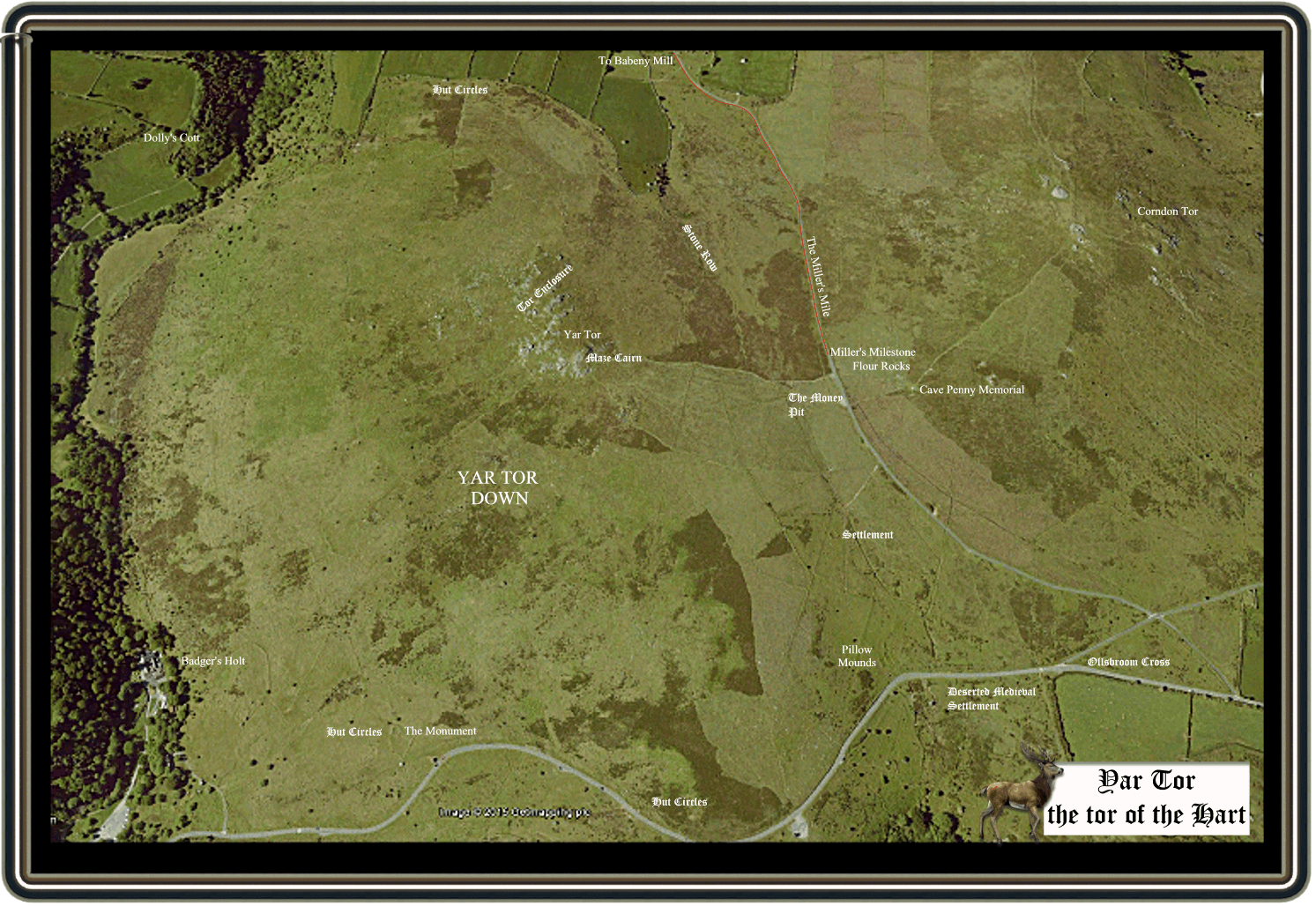
At the north end of the row is a cairn measuring six by six metres and standing to a height of about one metre, at the southern end of the row sits the ‘Money Pit’.
On the southern outcrop of Yar Tor are the remains of a prehistoric cairn which stands up to around two metres high which has been altered into what today is called by some the ‘Maze Cairn’. Somebody or some persons have seen it fit to rearrange the stones into a spiral shape starting from the external edge and curving into the centre. This feature is that blatantly obvious that it can be identified from an altitude of 1.37 km above the ground.
On the northern end of the tor is a small rock pile and depending on how much one has had to drink definitely takes on the form of a shark’s face. In fact with plenty of ‘glider fuel’ the other end resembles a porpoise’s head or is that just me?
Another prehistoric feature with a modern story affixed to is the the hut circle known as ‘The Monument‘ and can be found on the southern slopes of the tor. Basically this is a hut circle that had some slabs added to it to commemorate Queen Victoria’s Jubilee.
On the northern outcrop of Yar Tor are the remnants of what has been classified as a ‘tor enclosure‘ of which there are but a few identified examples on Dartmoor, White Tor being another.
A stroll down the southern flank of Yar Tor will transport one from the prehistoric period into the medieval period. For just west of the road junction at which Ollsbrim cross sits are the remains of a deserted medieval settlement. This comprises of what was three rectangular buildings thought to have been longhouses along with their associated field systems.
In 1613 Yar Tor was documented as being the northern boundary of Vag Hill Rabbit Warren which covered about 520 acres. The area of this warren ran from the River dart on the west and south-eastern sides up to Yar Tor on the northern side. From Yar Tor it then ran across to Corndon Tor and over to the Rowbrook, over to Logator (Lucky Tor)on the east and back down to the river Dart., Haynes, p.163. It is hard to be certain but on an aerial photograph of Yar Tor Down there appears to be four or possibly five pillow mounds just above the road on the lower south east slopes of the tor?
As mentioned above to the east of Yar Tor runs the road leading down to the old ancient tenement of Babeny which dates back to at least 1260. Part of the settlement is the old corn mill. Part of this road is called the ‘Miller’s Mile‘ because basically it is exactly a mile from the mill. To mark this point is the Miller’s Mile Stone’ the purpose of which was to signify the point where the road levels out after the steep climb from Babeny, it was here that travellers would mount their ponies or packsaddle ponies. Nearby to the milestone is a group of rocks called ‘Flour Rocks’ which one might think clearly has some association with Babeny Mill. They would be dead right as well, tradition has it that once a pack horse shed half its load of flour whilst returning from the mill. The flour then coated the nearby rocks thus giving them a white dusty coating which lasted for several weeks – hence Flour Rocks. Hemery, p. 529.
On the lower north western slopes of the tor, just on the opposite side of the river are the ruins of what in known as Dolly’s Cott. This is where a jealous husband moved his attractive wife to live in order to keep her out of the prying eyes and hands of the local nobility and royalty of the time.
Whilst searching the interweb I came across an excellent site that contains and short video showing fantastic aerial footage of Yar Tor taken with a Quadcopter Drone which can be found – HERE. Amongst other features there is a great view of the tor enclosure and maze cairn.
The God of light, in silver car,
Has climbed the hills of distant Yar;
And on the mountain top is born
The fragrant, dewy, smiling morn.
As sponsors for the future day;
And underneath are freshly spread
The dew-drops that bedeck her bed.
The ruddy cock has clapped his wings,
And loud his grateful matin rings.
Rev.E.W.I.Davies-1893-Dartmoor Days

Baring Gould, S. 1982. A Book of Dartmoor. London: Wildwood House Ltd.
Clark Hall, J. R. 2004 A Concise Anglo-Saxon Dictionary, Canada: Cambridge University Press.
Haynes, R. G. 1970. Vermin Traps and Rabbit Warrens on Dartmoor – Post Medieval Archaeology – 4.
Hemery, E. 1983. High Dartmoor. London: Robert Hale Company
King, R. J. 1856. Dartmoor and its Borders. London: John Russell Smith.