 Legendary Dartmoor The many aspects past and present of Dartmoor

According to the Place-Name Society, Gover,Et.al.1992, pp.197-198, the name of the tor was first documented in the Court Rolls of 1481 as Walterydonne. It next appeared as Waterndown(e) in 1520 and then in 1609 as Waterdontorr, this changed slightly in 1702 to Walter Tor. The general consensus of opinion is that the modern name Watern is a corruption of Waterdon which means Water (water) Hill (dun) thus giving the ‘tor on the watery hill’. However, another possibility is that the first element is of a personal nature and is Walter thus giving ‘Walter’s Hill’. William Crossing also throws in an additional name of Watern Borough although he did not mention from what source it came, Crossing, 1990, p.239. Personally I would go with the ‘water’ theory as every time I have visited the tor there has been plenty of evidence of it, mostly falling from the sky in torrents.
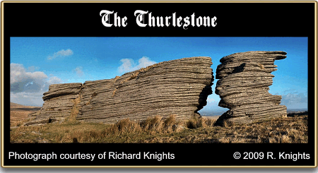
However, if one steps back further in time it soon becomes clear that the tor was once known as the Thurlstone, a name which appears in the Perambulation of 1240; ‘et inde linealiter usque ad Thurlestone‘, Brewer, 2001, p,23. William Crossing defines this a bit more when he states: “Thurlestone is the name attaching to the two northern piles only”, 1990, p.239. This name in itself has over the centuries been a bone of contention, not because of its etymology but more of its location. As noted above, the name appeared in 1240 as a boundary marker for the Forest of Dartmoor but in later years a boundary dispute led to the theory that the Thurlestone was in fact another name appended to the Whitmoor Stone. The resolution to this argument surely comes from the place-name’s roots, the Old English word pyrel, Ekwall, 1980, p.471. meaning ‘holed’ and stan ‘stone’ thus arriving at ‘holed stone’. Under no circumstances of the imagination is there a hole anywhere to be seen on the Whitmoor Stone whereas there is a massive one on Watern Tor. Since the military began using Dartmoor as a training area Watern Tor has yet another boundary which it marked, namely the Okehampton Range. Fortunately it has been spared the indignity of having an observation post slapped on it which is one blessing and has now been moved out of the firing line so to speak with the advent of recent boundary changes.
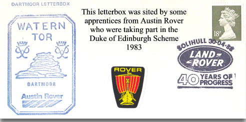
Not only does Watern Tor act as a Dartmoor Forest boundary point it also serves as one for the parishes of Gidleigh and Throwleigh which as it’s such a prominent landscape feature is not surprising. Sometime in the 1600s the parish of Gidleigh beat their bounds and a document of that event record how when the parishioners reached Watern Tor one Elizabeth Discombe roasted a ram there, Brewer, p.63.
But hey, what’s in a name and why single out this tor for attention when there are literally hundreds of others? The main reason is its geology as it serves as an excellent example of horizontal jointing.
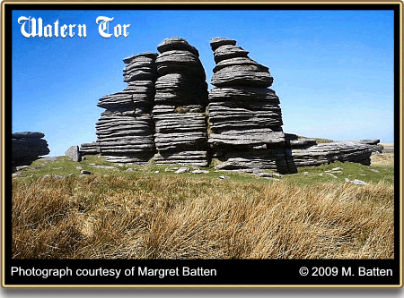
‘Watern Tor is one of the many remarkable natural formations of the granite rock which will repay a more particular examination. It consists of a series of piles, rising from the ridge of the hill, the stratification of which presents the appearance of laminar masses, in a horizontal position. The two piles at the N.N.E. extremity, in one part, near the top, approach so closely as to appear to unite, when seen from some points of view, leaving a large oval aperture in the tor, through which moormen say, a man can ride on horseback. But on a closer examination, it will be observed that there is an interval of at least one foot wide in the narrowest part; and in the widest, the piles stand about eight feet apart, leaving ample room for man and horse to pass through. This aperture appears to have given rise to the name of Thirlstone by which part of the tor is known.’, Rowe, 1848. p.73.
James Perrott the famous Dartmoor guide had another theory; “Thei du tall I as haw them here meurstones wos cast up laike by a gert faire fro’ th’ inside o’ th’ earth, but I do knaw better, twadna jist noa sich thing, fur ye see them marks was maid by water, when th’ fleud di wash over th’ meur, an’ th’ crumbly bits of the stoan was washut dawn the hullside, an’ th’ hard bits was left stanning, but thai was all knockut an’ brackut about like them here. Thut’s haw it were sur.”
Horizontal joining occurred when the old rock roof of Dartmoor was removed by mechanical and chemical weathering, the removal of this weight allowed an upward adjustment of the then lighter granite thus resulting in stress-released joints, Perkins, 1972, pp.38 – 39.
In the case of Watern Tor these appear from a distance as being individual horizontal slabs of granite all piled on top of each other. This process of joining is still occurring today, if anything at a quicker rate because the joints have widened thus allowing a greater degree of mechanical weathering. As can be seen from the photograph below, when viewed from certain angles the formations of granite can take on, with a bit of imagination, numerous likenesses. Does not the pile on the left resemble a sitting, tubby man wearing a flat cap? As the tor was once known as Walter Tor maybe he should be dubbed ‘Watern Walter’.
As can be seen from the photograph below the Thurlestone’s gap is certainly wide and tall enough to ride a horse through and has become the subject of many landscape photographers. Sadly, I cannot add my photographic efforts to this as a recent combination of a crashed computer and not having backed up my system has left what examples I had somewhere where the sun don’t shine, hence these two works kindly donated by Margaret Batten and Richard Knights.
Over the millennia Watern Tor has seen a fair bit of human activity, the cairn on its summit will testify that prehistoric man decided that its dramatic presence in the landscape made it a fitting place to bury their dead. In later times the tinner was very active along the nearby Wallabrook which flows past its western flank. There are no less than three recorded tinner’s huts located just below the tor which is a sure sign that the ‘old men of the moor’ found what they were looking for.
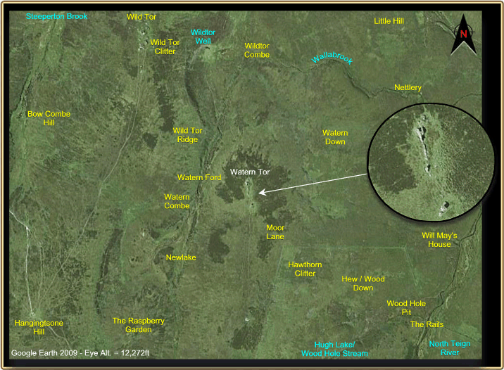
Aerial View and Map

Brewer, D. 2002. Dartmoor Boundary Markers, Tiverton: Halsgrove Publishing.
Crossing, W. 1990. Crossing’s Guide to Dartmoor, Newton Abbot: Peninsula Press.
Ekwall, E. 1980. The Concise Oxford Dictionary of Place Names, Oxford: Claredon Press.
Perkins, J. W. 1972. Geology Explained: Dartmoor and the Tamar Valley. Newton Abbot: David and Charles.
Rowe, S. 1848. A perambulation of the ancient and royal forest of Dartmoor, Plymouth: Rowe and Hamilton & Adams.