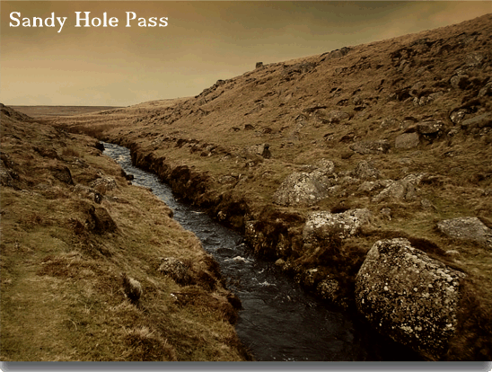
“Here is the evidence in plenty that even in that remote spot the miner ‘streamed’ for tin. For, just above it advantage has been taken of a little rocky pass through which the Dart makes his way to further confine the stream within rude granite walls. The hollow is known as Sandy Hole, from the quantity of sand which is washed up from the banks of the stream. It is a desolate spot, and on the western slope the snow lingers long. I have found a drift here in April long after it had disappeared from the surrounding moor.”. Page. p.132.
So speaks John Lloyd Warden Page when he describes Sandy Hole Pass and as can be deduced he was none to impressed. In a way I can’t say I blame him because in some peoples eyes any industrial archaeological remains can seem drear to say the least. Having recently posted a webpage on the East Dart Waterfall it only seemed logical for this page as it only lies about 700m to the north-west.
Basically the whole area around the upper reaches of the East Dart were extensively ‘streamed’ for in, the whole area covering around fourteen hectares. Today the evidence of these extensive workings can be seen in the form of various channels, spoil heaps, tinner’s huts and what lies in Sandy Hole Pass. As the very name suggests it is one of the numerous Dartmoor’s Holes and is one where the East Dart river has deposited large quantities of sand.
It was here that the ‘Old Men’ straightened the banks of the East Dart river and revetted their sides with stone walls. There are two theories as to why this was done; William Crossing suggests that it was to store the water in a dam like structure, probably at the lower end of the pass, for use by the tinner’s, p. 476. The other idea was that its purpose was to drain the wetlands of Broada Marsh whilst supplying water to carry away the tin wastes and accumulations of sand. In the early sixteen century the busy harbour at Dartmouth became silted up thus causing problems for ships docking. Hemery has attributed this problem directly at the tinners activities in Sandy Hole Pass. Around about the same time Plymouth docks were also having similar problems with silting-up and so Richard Strode, a local member of parliament of the time took these matters up with Westminster. He probably wished he hadn’t because the stannary authorities immediately fined him £160. He refused to pay the fine which resulted in him landing up in Lydford gaol. He crime was to interfere with the accepted rights of the Dartmoor tinners who at that time due to the revenues tin brought in were beyond reproach. Hemery, p.536. In effect the whole idea was to narrow the flow of water thus speeding up its rate of travel. This then meant that any waste from the mining operations was easier to flush away as opposed to carting it off. To the best of my knowledge the huge granite walls of the pass are the largest example of such a structure being used in this manner on Dartmoor. At the lower end of the pass is a spot known as ‘The Oak and The Ash’, due to the presence of both species of tree.

Thanks to Richard Knights for the use of this photograph taken from his Dartmoor Walks website
You can see from the map opposite the large number of tinner’s hut remains that are scattered around the vicinity of the pass. This alone would indicate the extent of mining that took place here between Medieval and Post Medieval times. As can be seen from the table below there is a great variation in the sizes of the huts with example B probably being used for storage as opposed to dwelling.
| Hut letter on Map | Ordnance Survey Grid Ref. | Hut Dimensions | Visible Wall Height |
| A | SX 6242 8122 | 6.6m x 2m | 1.2m |
| B | SX6167 8162 | 2.4m x 1.4m | 0,8m |
| C | SX 6216 8150 | 4.4m x 2m | 1.1m |
| D | SX 6146 8185 | Ruinous Condition | Ruinous Condition |
| E | SX 6134 8149 | 4.9m x 2.6m | 0.7m |
| F | SX 6174 8166 | 5.5m x 2.5m | 0.9m |
| G | SX 6186 8183 | 6m x 3.6m | 0.8m |
Applicable to any Dartmoor stream works, it does make one realise the harsh life these early tinners led. Imagine standing for the most part of the working day in cold, running water, heaving rocks around, and then retiring to the comfort (not) of a rude granite shelter. In most cases their workplace was in the wild and remoter spots of the moor and open to whatever weather it decided to throw at them.

Crossing, W. 1990. Crossing’s Guide to Dartmoor. Newton Abbot: Peninsula Press
Hemery, E. 1983. High Dartmoor. London: Robert Hale.
Page, J. Ll. W. Page. 1893. The Rivers of Devon. London: Seeley and Co., Ltd.
 Legendary Dartmoor The many aspects past and present of Dartmoor
