 Legendary Dartmoor The many aspects past and present of Dartmoor

The’ hill where bounds abound‘ is just one of the accolades that Ryder’s Hill can boast, another being that at 515m it is the highest hill on Southern Dartmoor. Ryder’s Hill could also be described as the frontier between fen and moor as to the east lie the typical Dartmoor moorlands and valleys whilst to the west festers the boglands of Aune Head and Fishlake mires. Ryder’s Hill is also witness to the birth of three watercourses; the river Aune or Avon, the river Mardle and the Western Wellabrook. The Aune springs up on the hill’s north western flank, the Mardle on the east flank and the Wellabrook at its southern foot.
On a clear day the views from Ryder’s Hill extend over into Dorset and Cornwall, William Crossing claims to have seen the Isle of Portland and the Lizard Point, p.362. Personally I cannot confirm any of these landmarks as on every occasion I have visited the hill it has either been tipping down with rain or shrouded in mist. But thanks to its prominence and visibility within the landscape Ryder’s Hill been used by man as a prehistoric burial site, a location for various boundary points and latterly an Ordnance Survey triangulation point. Therefore one could say that as Dartmoor’s prominences go Ryder’s Hill is one of the more interesting.
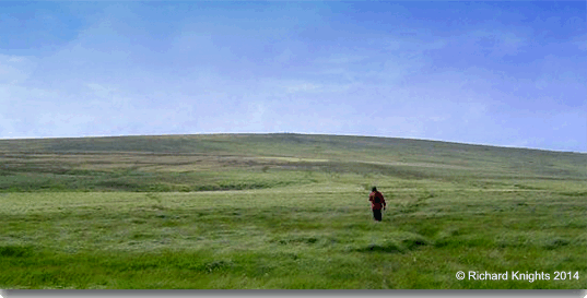
Many thanks to Richard Knights for allowing me to use his photographs taken from his Dartmoor Walks website
As always let’s start with the origins of the hills place-name which as they go has changed from various two element descriptive names to one with both a personal and a descriptive element. To explain, in the 1240 perambulation of the Forest of Dartmoor the hill was one of the boundary points. As the original document was lost several copies were made in which the place-name spellings vary. In this case the hill was recorded as; Battyshull , Gnatteshulle and Gnatesburghe, later spellings are documented as Gnatteshill, Gnattleshill, and Knattleburroughe. If the Gnatteshulle version is accepted as the original one then the English Place-Name Society suggests that the name derives from either the Gnatt element referring to the insect gnat which is derived from the Anglo Saxon word – Gnæt, Clark Hall, p. 157, or it’s a personal name element of medieval origin, Gover et. al.,p.197. If one prefers the Gnatesburghe version then the two elements would be Gnates which again could refer to either the insect or a personal name. The second element burghe would be associated with the Bronze Age cairn which lies on top of the hill as such monuments are often referred to burghes, boroughs or burrows in place names Either way you would end up with a modern version of ‘the hill or cairn of the gnats’ or the ‘hill or cairn belonging to or associated with someone called Gnat’. As to Battyshull I would suggest this is a result of a mistranslation or spelling when copied from the original document of 1240 later adopted by Tristram Risdon in his Survey of Devon
So how can there be such a deviation from the old names as noted above to simply Ryder’s Hill? I must admit that having never given the name much thought it was a surprise when I came across the reason. In 1847 a married couple who lived at Lydia Bridge died within a two weeks of each other, both were aged 56. They must have been a well liked and prominent couple either that or the hill was of some significance to them as shortly after their deaths the hill became known as Ryder’s Hill or simply Ryder’s, Hemery p.303, footnote. This name has ever since been tagged to the hill as a look at any Ordnance Survey map will testify.
As noted above, there are the vestiges of a cairn upon the summit of Ryder’s which dates back to the Bronze Age. It consists of a circular platform that has a diameter of 30m and at the highest point a width of 12m and a maximum height of 1.5m, Butler, p.173. Some of the stones have been removed, probably to provide packing for the sockets of the two nearby boundstones.
Next we come to the boundstones that abound on Ryder’s of which there are seven dotted around the hill plus a couple of B Rocks. The difference between a boundstone and a boundary rock is that boundstones tend to be man made whereas boundary rocks are natural landscape features used as a boundary point. As mentioned above, although there was no boundary stone as such on Ryder’s Hill it was the boundary point documented as Battyshull etc. on the 1240 and later perambulations marking the Forest of Dartmoor. Then there are the later boundary markers which belong to the Holne and Buckfastleigh bounds which are marked with either an ‘H’ or ‘B’.
Starting on the northern flank of Ryder’s the first boundary marker to appear is a B Rock which is incised with an ‘H’ located at Wellaby Gulf (OS grid SX 6593 7011). Then moving southwards is another B Rock located just above the Sandy Way (OS grid ref. SX 6595 6968) again marked with the letter ‘H’. Immediately below is the first actual boundstone, again marked with an ‘H’ and known as Fieldfare or Filfer Head. Possibly the name alludes to a favourite winter haunt of Fieldfares? The boundary line then head to the summit of Ryder’s where it meets the next boundstone named ‘Little Anthony’ (OS grid ref. SX 6596 6919), again marked with an ‘H’. It has been suggested that this name refers to diminutive Brother Anthony who was a one-time monk of Buckfast Abbey which once owned the rights on Holne Moor, Brewer, p.120.
Just below here is the Holne boundstone known as Petre’s-on-the-Mount (OS grid ref. SX 6597 6906), just for a change the incised letter is ‘H’. Beside this is a much larger boundstone known as Petre’s Stone (OS grid reference SX 6592 6901) and is marked with a ‘B’ . Over the years both boundstones have directly or indirectly caused much confusion. The first ‘bone of contention’ was that of the Holne parishioners who claimed that their original boundary point lay beneath the modern(ish) trig. point. The second ‘issue’ concerns what appears to have been some name swapping and is a very confusing story, so to make things simple (for myself) I will quote Mike Brown’s words;
“The Buckfastleigh stone has in more recent years always been called Petre’s Boundstone, the Holne one known as Petre-on-the-Mount, but it seems that both names have been applied to different stones at various periods of their history. The original ‘H’ set stone was apparently called called Petre-on-the-Mount prior to the erection of the Buckfastleigh boundstone This latter was erected when the Holne stone had become broken and apparently took its name, and for many years the Holne stone was not remarked upon at all in boundary reports. The ‘H’ boundstone then resurfaced and for some years lay loose beside Buckfastleigh’s tall ‘B’ pillar, the site then becoming referred to as either Petre-on-the-Mount or Petre’s Boundstone. Following the disappearance of Holne’s stone again (sometime prior to 1986), a replacement was erected in 1991.”p.5.
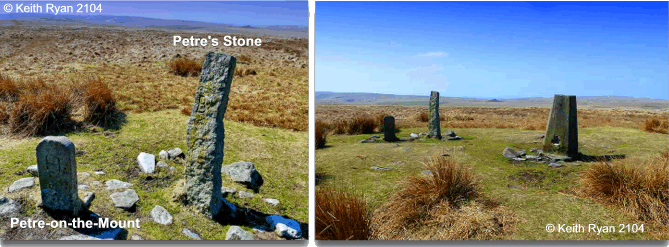
Many thanks to Keith Ryan for allowing me to use his photographs taken from his Dartmoorcam website
So now wander slightly north-west of the summit and you will arrive at The Nine Stones (OS grid Ref. SX 6612 6918) which is marked with an ‘H’. Nearby at the top end of a tinner’s pit is the Bourne’s Pit stone (OS grid ref. SX 6620 6921) and just to change the tune a bit this one is marked with a ‘B’. Next we arrive at the last easterly boundstone that could be associated with Ryder’s Hill and that is the Rounder’s Hole Stone (OS grid ref SX 6649 6924) which is marked with the letter ‘H’. Last but not least there is a final boundstone that lies on the southern edge of Ryder’s and is known as the Wellabrook Stone (OS grid ref. SX 6646 6856) and refreshingly its marked with a ‘B’.
Some could say that the crowning glory of Ryder’s Hill is the triangulation point which caused the spot of bother with the folk from Holne, it was erected in 1937 and bears the numerical identifier of 1740
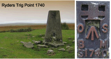
Thanks to Tim Jenkinson for these photos taken from Flickr
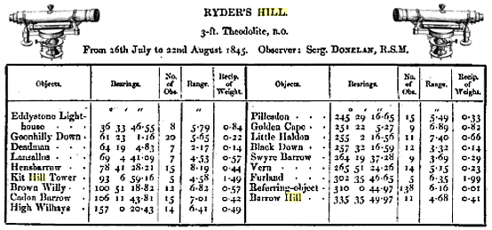
As mentioned above, it was claimed that this trig was erected over what was the original Holne boundary point and considering the size of Holne parish it seems a trifle OTT to moan about a few feet? Anyhow, in order to try and resolve the matter Eric Hemery wrote to the Ordnance Survey and received a reply which stated that the “triangulation-pillar on Ryder’s Hill Dartmoor was built in March 1937, exactly over the old, buried triangulation mark.”. This lead him to assume that the OS mark was placed under what then was called Petre-on-the-Mount and the stone had indeed been moved to make way for the offending trig point, p.303. Several years later Dave Brewer was not convinced and he wrote a further letter to the Ordnance Survey and subsequently received a more informative reply. They stated that originally the observations were taken between the 26th July and the 22nd of August 1845 by Sergeant Donelaw RSM. The actual spot or mark which he used to take his sightings was 2ft 6″ below the ground. After the task had been completed a turf pile 12ft in diameter and 13 feet high was placed over the mark station. The letter also went on to say that there was no way that any Ordnance Surveyor would interfere with boundstones as it was not only improper but against their own interests. Brewer also managed to get a copy of the original letter sent to Hemery and discovered that Hemery had omitted some vital wording. The letter clearly laid out the account of a 1858 survey in which it stated that; “About 12ft south from the station stands a stone with the letter ‘H’ rudely cut upon it, to mark the limit of the parish of Holne in this direction.” This confirmed to Brewer that in 1858 the original boundstone was standing 12ft south of the O. S. station and that the later ‘B’ stone was erected on the exact same spot pp. 120 – 123.
Having no knowledge of surveying techniques I think that in order to take accurate bearings it was vital that some level ground was found on which to stand the theodolite. Once this had been established the various ‘observations’ were taken and in order to be able to re-locate the spot at later dates a visible mound was built over the spot. In 1858 H. James published a book containing details of all the early O.S. observations and for Ryder’s Hill he notes the following: “The entire framework used in support of the great instrument (theodolite) was left in position, and a stone, with a small hole 2 inches deep to mark the centre, was also placed on the gravel within the frame, the interior of the frame is filled up with stones level with the surface, and a turf pile, 12 feet in diameter and 13 feet high was erected above it.”, James, p.53. This confirms exactly what the Ordnance Survey stated in their letter. His book also records the actual observations taken by Sergeant Donelaw RSM on Ryder’s as shown below:
So there you have Ryder’s Hill, the big hill (as far as South Dartmoor goes) with vast views, numerous names, abounding with bounds, crowned by a redundant trig point once accused of trespass and a Bronze Age cairn thrown in for good measure.
Oh and lastly, Ryders was/is known to be one of the haunts of Dartmoor’s infamous Black Dog, it was over here that poor Luke Rogers was chased so just be careful after dark.

Brewer, D. 2002. Dartmoor Boundary Markers. Tiverton: Halsgrove Publishing.
Brown, M. 1998. Dartmoor Field Guides. Plymouth: Dartmoor Press.
Butler, J. 1993. Dartmoor Atlas of Antiquities – Vol. 4. Exeter: Devon Books.
Clark-Hall, J. R. 2004. A Concise Anglo-Saxon Dictionary. London: University of Toronto Press.
Crossing, W. 1990. Crossing’s Guide to Dartmoor. Newton Abbot: Peninsula Press.
Gover, J. E. B., Mawer, A. & Stenton, F. M. 1992 The Place Names of Devon, Nottingham: English Place-Name Society
Hemery, E. 1983. High Dartmoor. London: Robert Hale.
James, H. 1858 Account of the Observations and Calculations of the Principal Triangulation etc. George Edward Eyre
2 comments
Pingback: Ryder’s Hill, Dartmoor – My Blog
Pingback: Ryder’s Hill, Dartmoor – Eat Sleep Wild