 Legendary Dartmoor The many aspects past and present of Dartmoor

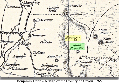
Roos Tor, one might be forgiven for thinking it is something out of a Winnie the Pooh book but as far as I know Roo never stepped foot on Dartmoor. According to the place-name society the first recorded name for the tor was Rulestorre which appeared in a document of 1665. Gover et. al., p.233. One hundred years later it appeared on Benjamin Donn’s map as Roose Tor and as can be seen below somehow it acquired a big brother in the form of Great Roose Tor. There must have been some confusion here as today Great Roose Tor is referred to as Great Staple Tor.
Just to thrown another name in the mix the tor has also been known as Rolls Tor according to Baring Gould, p.78. Worth suggests that the name derives from the Anglo Saxon word Hruse meaning ‘ a rock’ or ‘a hill’, p.428, which in this case would be quite apt.
In 1826 Eliza Bray wrote of her visit to Roos Tor and here is a brief synopsis of her visit:
“After passing near some pits or trenches, which we imagine are the vestiges of stream works, we met an aged shepherd, who was collecting his flock, and informed us the hill we were ascending was Roosetor. This name may possibly be derived from Rhôs or Rôo, signifying, in Welsh or Cornish, a healthy mountain… The south side of the tor has a grand and picturesque appearance. Two immense piles of rocks are of so pendent a form as to threaten every instant to fall upon the beholder… On another pile, which was fifteen high, we found two basins – one two feet by one and a half; the other one foot in diameter… Another pile, though much lower, we ascended with the greatest difficulty. On the top of it were a few imperfect basins. But a mass of rocks, near the latter, afforded us a very curious specimen of the works of the druids. On the uppermost stone of the mass we discovered a basin, in depth a foot and a quarter, with smaller ones surrounding it, and little channels communicating with others in a serpentine direction. On this tor we found a sheepfold between some rocks, which were serviceable in the formation of it; and were informed by another shepherd that it was still used.”, pp. 237 -239.
Clearly from her description we can see that Roos Tor was a favourite lairage where flocks of sheep would graze and by the way still do today. Also here is another prime example of how the early antiquarians attributed various natural rock features as being Druidical ritual monuments.
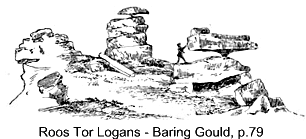
Nature has done an excellent job of slowly sculpting the granite on Roos Tor with two of the features associated with weathering. At one time there were two ‘rocking’ or logan stones and a whole series of rock basins. . In fairly recent times man, in one way or another, appears to have done his utmost to remove the place from the landscape as will be seen below. Baring Gould notes how; “Roos Tor, possessed two logan stones, but the quarrymen have destroyed one, together with the fine masses of rock on which it stood,” p.78. Included with his text was an illustration of Roos Tor showing its two logan stones drawn in 1852. Today there still remains one of the two logan stones which with a little effort will still ‘log’.
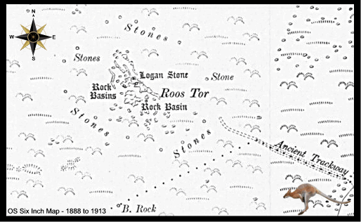
During the Bronze Age the area around Roos Tor was fairly heavily populated and today remains of their hut circles and reaves are still evident today. As can be seen from the early Ordnance Survey map below it was thought at this time that the ‘Great Central Trackway‘ ran up to the tor. Today this supposed man-made trackway is known to be a prehistoric reave which is part of the ‘Great Western Reave’. Additionally on the north-west slopes of Roos Tor are the remnants of a large prehistoric settlement comprising of twenty one huts and field enclosures.
There can be no question that Roos Tor had suffered badly at the hands of the stone cutters so much so that in the mid 1800s the Duke of Bedford erected a series of protective markers stones around the tor inside which stone was not to be taken. There were fourteen in number each consisting of a bisected circle which were carved into natural rocks. It has been suggested that the original markers were put in place about 1847 and were then replaced around 1890 with a series of more substantial stones. Each stone being of dressed granite standing about one metre high with the letter ‘B’ on the side facing away from the summit. Brewer, p. 251 & Pastscape record 1406369. An example of both the original marker stone and the replacement stone can be seen opposite. Despite all the good intentions the protective ring of markers had very little effect and stone continued to be removed despite several attempts to prevent it happening. A full list of all fourteen markers and there OS grid references can be found on the DartmoorCam website – HERE.
In 1947 R. H. Worth prepared on behalf of the Devonshire Association his thoughts on the what he called a ‘deposited map’ lodged by the military with the Devon County Council. This basically was a proposal of how Dartmoor should be divided for the purposes of training and live firing. In his opinion the ‘gun areas’ would in many cases cause; “irreparable damage” to the moor. In this respect, once again poor old Roos Tor came, literally, into the firing line. Below are his thoughts on the proposed plan:
“Gun area on Roose Tor and Great Staple Tor. Extreme length north to south rather over three-quarters of a mile, extreme width east to west rather less than three-quarters of a mile, extreme width east to west rather less than three-quarters of a mile. This again, is an unfortunate selection, ome attempt seems to have been made to avoid the summit rocks of Roose Tor and Great Staple Tor, but the attempt is far from sufficient, and both rock masses are involved, while the guns are set south of the tors, which, with a northward direction of fire involves the rocks being subject to the blast. A number of hut circles are also involved in the area. The only possible method of avoiding damage is to shift the gun area to the north-east, clear of both tors. Also this gun area is within the limits of the battle practice with live ammunition; and we know the manner in which such rocks have been regarded by the services as target made and appointed for their purposes… Worth, pp. 491 – 492.
If you look at the extent of the Merrivale Range today you will see that Roos Tor has been kept out of the zone and the limit neatly circumnavigates Great Mis Tor on its eastern flank – but only just. The only visible military infringement to Roos Tor is the placement of a flag pole.
Today the tor is popular with walkers for the wide, extensive views that can be seen from its summit. The tor is encompassed in a designated Site of Special Scientific Interest and so is now afforded a greater degree of protection. Although Roos Tor is not what could be considered one of the most ‘craggy’ of Dartmoor tors there are several rock climbs mapped around its outcrop. Here you can find; Laidback Jack, Outright Denial, Kanga, Mucky Groove and even Clenchy Bum Time to name but a few.

Baring Gould, S. 1900. A Book of Dartmoor. London: Methuen &Co.
Brewer, D. 2002. Dartmoor Boundary Markers. Tiverton: Halsgrove Publishing.
Gover, J. E. B., Mawer, A. & Stenton, F.M. 1992 The Place-Names of Devon. Nottingham: The English Place-Name Society.
Worth, R. H. 1988. Worth’s Dartmoor. Newton Abbot: David & Charles.