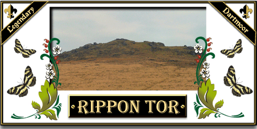
 Legendary Dartmoor The many aspects past and present of Dartmoor

I tramp o’er the moors in the fresh morning air,
The breeze in my face, so bracing and rare.
Deep golden gorse amidst heather I saw,
Whilst climbing “up over” high Rippon Tor.
The track through the bracken on velvety turf,
Grey rocks, lichen-cover’d, and red-brown earth,
Wild shaggy ponies that graze on the moor
Watch me climb “up over” high Rippon Tor.
Whortle berries brushed with purple-hued bloom,
Their leaves vivid scarlet, and all attune
With ling and trefoil bespangling the moor
Like a patchwork carpet o’er Rippon Tor.
The views from the crest are a joy to behold,
Peak’d hills and far distant tors they enfold,
The sun-touched sea shines all bright like ore,
As I stand right atop of Rippon Tor.
Violet Francis
Poor old Rippon Tor, it sits quietly on Horridge Common and is overshadowed by the famous Haytor and Saddle Tor. All the visitors flock to scramble up Haytor and pass Rippon without a second thought. Yet as tors go there is much more of interest here than on any of its nearby neighbours. Here you have a whole palimpsest of activity that starts with the Bronze Age and ends with modern times. But as always the story begins with the origins of the actual place-name of the tor. According to the Place Name Society (Glover et al., 1998, p.478) the earliest recorded entry of the tor is in the Recovery Rolls of 1726 where it appears as Rippentorr. Later in 1827 this had mutated to Rippen Tor although Hemery, (1983, p.684) notes how on the 1841 Tithes Map the alternative name of Raven Tor is listed. Both have now been replaced by the modern name of Rippon Tor which has appeared on the OS maps since at least 1886. It appears as nobody can give any suggestions as to what the name means.
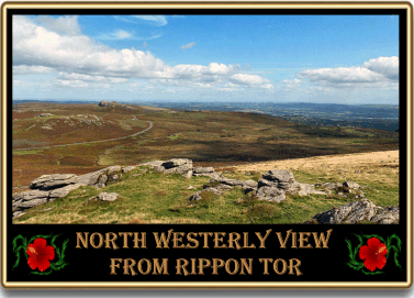
The actual tor consists of several separate rock piles that sit at an elevation of 473m and affords sprawling views in most directions. Page (1895, p.217fn) mentions a letter in which it was stated how when the first triangulation of Devon took place the surveyors exchanged signals between Rippon Tor and Wells Cathedral, a distance of about 66 miles as the crow flies. The tor has for centuries been a landmark used by sailors when coming into the harbour of Teignmouth and Dartmouth as noted here: ‘The entrance to Dartmouth is 5 miles S.W. by W. of Berry Head, and its position mat be recognised at sea by the granite peaks or tors, which break the outline of the Dartmoor range. The most remarkable of these are the Haytor and Rippon tor, the latter, 1,525 feet above high water, being easily distinguishable from the former by its single culminating point or cairn… Rippon tor bearing N. ½ W. leads to the entrance of the harbour…‘, (Admiralty H. D. Dept, 1863, p.97). In 1842 it was reported that; “a scientific gentleman has visited this neighbourhood during the week, for the purpose it is stated, of selecting a situation for the erection of a telegraphic establishment. It is supposed that Rippon Tor, a lofty eminence, which is 1549 feet above the level of the sea, and of which a fine view can be had from the west end of this town, will be selected as the spot. On this tor, during the time of the threatened invasion of this country by Bonaparte, about the year 1758, an immense sized lamp was fixed and lit every evening, for the purpose of making communications, and was attended by two artificers.” The North Devon Journal, December 15th 1842 Again, the elevation of Rippon Tor attracted the attention of the OS surveyors who in 1842, along with a party of sappers and local miners set up camp on the tor in order to take observations for perfecting the Ordnance Survey map of Great Britain. In later years the Ordnance Survey placed a secondary flush bracket trig pillar on the tor (No. 3457) at the centre of the cairn and if you fancy a bit of trivia this is the eighth highest trig on Dartmoor. In 1844 it was said that from the top of Rippon Tor you can see 34 church towers.
In Some say ’tis best to start at the bottom and work up so in that light let’s have a look at the bottom layer of activity on Rippon Tor. For this we need a JCB and a trowel both of which will reveal several Bronze Age features. Firstly, on the top of the tor are the remnants of three cairns, the one built on the highest rock is reputed to be one of the largest examples on Dartmoor with a diameter of 28m and a height of 4m, (Butler, 1991, p.42). The other two cairns lie to the south-east and pale into significance with diameters of about 20m. Also evident on the tor are the vestiges of two parallel reaves or Bronze Age boundary walls. These belong to a much larger system of reaves known as the Rippon Tor system which according to Darvill (1996 p.109) covers some 3,300 hectares. Todd (1987, p.117) suggests the extent of the Rippon Tor system may have even been as large as 4,500 hectares, either way it’s the largest in Britain. Also associated with the two reaves is a connecting cross-bank which separates the cairns and the tor in what could be a deliberate attempt to divide the ritual area from the field system. There is also evidence that Bronze Age man settled on the eastern and southern flanks of the tor in the form of hut circles, two of which stand about 200m beneath the summit. A smaller isolated hut is situated to the north of the tor with another about 60m away. Both of these building were not associated with any fields and so it is possible they were used for storage or temporary residence, Butler (p.43). It has also been muted by Hemery (p.686) that the eastern structure was a later shepherd’s shelter which is a possibility.
The story of Rippon Tor then moves on to possible medieval times and is represented by an unfinished Latin cross, this can be found lying in the turf about 20m to the west of the trig, see illustration 1.. Clearly the cross was cut in-situ and measures 2.02m tall and has a arm span of 58cm, Sandles (1997, p.84). Crossing (1987, pp. 161-2) takes the view that as the cross was cut in relief it was never intended to be erected. This may seem slightly puzzling but it must be remembered that many of the stone artefacts were carved in-situ and then moved off the moor. It was considered an easier method than hauling a huge slab of granite off the moor and then carving it in some yard. It seems that both he and Spence Bate were of the opinion that the purpose of the cross was to free, “from evil those places where the mysterious rites of Pagan superstition had been observed…“. In other words the cross was intended to Christianise the Bronze Age or ‘Pagan’ burial cairns which I am sure would have pleased the ancients no end. Hemery (p. 684) tends not to agree with this theory and suggests that the cross was intended for completion and to be erected somewhere on the moor, possibly as a replacement for an existing cross. He also offers the theory that the work on the cross was carried out before the end of the sixteenth century. On the summit of the tor is further evidence that the stone cutter had been at work in the form of two unfinished mill stones, Crossing, (1990, p. 329).
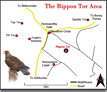
To the southwest of the tor is the site of what was reputed to be the largest logan stone on Dartmoor, known as the ‘Nutcracker’. Another claim to fame for Rippon Tor was that in 1891 it was the haunt of a golden eagle, a sight which certainly would not be seen today, (1990, p.329). Just below the tor is the small incised stone known as the Stentiford Cross which is embedded in the stone wall.
During the Second World War the newtake below the tor was used as a firing range and then later used for training cadets. During firing the red warning flag was flown from a pole on the tor and the area was watched over by two range wardens from Ashburton.
As far as the folklore of the tors goes there is not a lot to mention apart from the tradition that the Devil haunted the nearby prehistoric enclosures of Foale’s Arrishes. There is a story that a local man once built a hut in the enclosures with the intention of living there. Shortly after moving there he disappeared and was said to have been taken off by the Devil. Again this is another example of how prehistoric sites were viewed as being evil places and this story was probably used as a warning for people to stay away. Another tradition was local local folk would walk up to the tor’s summit on Easter Morning to see the sun dance in celebration of Christ’s resurrection.
Back in the 1930’s there was a famous racehorse called Rippon Tor who went on to win several big races such as the Liverpool Cup, he also ran in the Derby and many other major cups. The picture below just about shows Rippon Tor running at Epsom in 1937.


Admiralty Hydrographical Dept. 1863. The Channel Pilot, Part 1 2nd Edition.
Butler, J. 1991 Dartmoor Atlas of Antiquities – Vol. I, Devon Books, Exeter.
Crossing, W. 1990 Crossing’s Guide to Dartmoor, Peninsula Books, Newton Abbot.
Crossing, W. 1987 The Ancient Stone Crosses of Dartmoor, Devon Books, Exeter.
Darvill, T. 1996 Prehistoric Britain, Routledge, London.
Gover, J. E. B., Mawer, A. & Stenton, F.M. 1998 The Place-Names of Devon. The English Place-Name Society, Nottingham.
Hemery, E. 1983 High Dartmoor, Hale, London.
Page, J. Ll. W. 1895 An Exploration of Dartmoor, Seeley & Co., London.
Rowe, S. 1985 A Perambulation of Dartmoor, Devon Books, Exeter.
Sandles, T. 1997 A Pilgrimage to Dartmoor’s Crosses, Forest Publishing, Liverton.
Todd, M. 1987 The South-West to AD 1000, Longman, London.