 Legendary Dartmoor The many aspects past and present of Dartmoor

Over the years there has been much debate regarding the military’s use of Dartmoor as a training area and regardless of one’s views there is one undeniable benefit, namely the ‘Ring Road’ or ‘Loop Road’. This has not only given military access to the remoter parts of the North Moor it has provided an easy shortcut for civilians wishing to walk to such areas as Cranmere Pool. The normal starting place for such a walk is OP15 which lies at the southern end of the Ring Road. Prior to the road being constructed the normal route to Cranmere Pool would have involved a long and arduous 10 mile return trek which went across many bogs, streams and other unpleasantries. In the days before the introduction of OS maps this walk would usually involve the services of a Dartmoor Guide such as James Perrott of Chagford. Until a few years ago this very same walk consisted of a return walk of about 3 miles thanks to the Ring Road. Over the years this road has been used by heavy military vehicles of one sort or another which have caused many deep potholes, these have always been repaired in a fashion thus enabling normal cars to travel along it with caution. However, now there are proposals afoot which will block civilian access to three quarters of the Ring Road, including its most southerly point.
Twenty years ago this to me would not have seemed a big deal, but regular walking on Dartmoor has taken its toll and along with many other people I now find the Ring Road saves the old bones and joints no end. But exactly what is proposed, who is proposing it and what does it mean?
There are a whole series of ‘roads’ that criss-cross the Okehampton military range but all act as arteries that link up to the Ring Road otherwise known as the Circular Road as can be seen from the table below:
| Yes Tor Road | Gives access to Yes Tor from West Mill Tor Road |
| Black Down Road | Gives access across Black Down to West Mill Tor |
| West Mil Tor Road | Gives access from moorgate to Dinger Tor Road |
| Dinger Tor Road | Gives access to Dinger Tor from West Mil Tor Road |
| Rough Tor Road | Connects West Mill Tor Road with Circular Road |
| Quarry Road | Connects West Mill Tor Road with Halstock Road |
| New Bridge Road | Connects Dinger Tor Road with Circular Road |
| Sammy Arnold’s Road | Connects Dinger Tor Road with Circular Road |
| Halstock Road | Circular route around Halstock Down |
| East Okement Road | Outer route around East Okement Farm, connects Halstock road with Circular Road |
| Circular Road | Main Circular from Rowtor in the north and Okement Hill in the south |
| Splinter Road | Connects Circular Road with Steeperton Tor Road via Okement Hill |
| Okement Hill Road | Connects the southern-most part of Circular Road with Steeperton Road via Okement Hill |
| Steeperton Tor Road | Connects Okement Hill Road with Circular Road via Oke Tor and Steeperton Tor |
Their construction can be described thus:
‘Most of the tracks are formed by granite, with large setts placed alongside the edges to contain the smaller stones. Parts of other tracks lie on the underlying granite to provide the metalled surface. Where tracks go over peat, timber has been used to maintain the surface. Culverts, covered by flat granite stones are constructed at intervals. Some are simply cut into the ground while others are carefully constructed with dressed granite. The Circular Road and the Yes Tor tracks were tarmaced in the 1940s (possibly by American civil engineer troops?). Most stream crossings are by way of fords, all are well constructed with granite blocks with the water course at Okehampton Moorgate constructed of black bauxite blocks. There is a further ford west of Oke Tor formed of granite slabs but this was probably constructed to facilitate the extraction of tin or peat. Water is kept from the roads by the surfaces having either a slight tilt or camber to allow the water to flow into small ditches alongside the road metalling. These collect the water and take it to culverts. The majority of Dartmoor’s heavy rainfall is however, caught before it reaches the roads, this is achieved by a carrier drain of ingenious design that zig-zags alongside but at some distance from the upper limits of the road. It then meanders its way down the slope to a point closer to the road at the bottom of the incline. Here the water is allowed to drain into culverts.’, Francis, 2002, p.31.
The Dartmoor National Park Authority held a meeting on the 9th of January 2009 when the following report was discussed:
THE LOOP ROAD – Report of the Director of Park Management Recommendations: That the Authority:
(i) agrees to support in principle the proposals by the Duchy of Cornwall for future management of the Loop Road as set out in this report
(ii) authorises officers to continue discussion with the Duchy of Cornwall on the detailed implementation of these proposals
1 Background
1.1 The Loop Road (or Ring Road) is a stone track leading south in a loop from Okehampton Camp onto the high moor for some 5 kms (Appendix 1, see – HERE ). It was surfaced with tarmac around 1956 by the MoD without the express consent of the landowners, the Duchy of Cornwall (the Duchy) and forms part of the land which is licensed for military training. Members of the public have been able to use the road in two-wheel drive cars at times of non-firing since the 1950s until relatively recently. It is not a public highway.
1.2 The management of this road and its future use have long been under discussion. In the 1980s a policy of ‘managed decline’ was agreed in order to allow the road to revert to a stone surface whilst allowing access for military training. This policy has now resulted in a deterioration of the road and several sections are now no longer suitable for an ordinary car. This poses a significant risk to public safety.
1.3 The Dartmoor National Park Management Plan, in the chapter on Sense of Place – Tranquillity and Remoteness, identifies the use of military roads, green lanes and the open moor by motorised vehicles as aspects that can affect tranquillity and dark night skies and includes as a ‘Means to Achieve’ that ‘the future public use of military roads on Dartmoor is reviewed’.
1.4 It was expected that as the Loop Road deteriorated, vehicular access would become more difficult and eventually be restricted. Earlier this year, the Duchy therefore set up a small working party with officers from the Authority and the MoD to help scope options. A steer was sought from Members of the Park Management Working Panel and the Loop Road was discussed at their meeting on 11 April 2008. Members agreed that car access to OP22 and Newbridge should be maintained along with suitable parking and turning areas at both ends. Further scoping has now been carried out by the Duchy into the practicalities of this. In particular, since April with the heavy rainfall this summer, the road to Newbridge has further degraded to the point that only re-tarmac ing would now allow access by car. There is also very limited potential for parking and turning and together with archaeological constraints, this option is no longer practical. However there is now an additional proposal to carry out a small amount of work to maintain car access from Moorgate to near West Mill Tor (the Moor Brook track).
1.5 Proposals for future management of the Loop Road have now been confirmed by the Duchy and they have written to a number of interested parties to gather views including the National Park Authority, local town and parish councils, the Dartmoor Access Forum and Dartmoor for All.
2 The Proposals
2.1 As shown on the Map (Appendix 2), the Duchy of Cornwall proposes to: (see – HERE).
a) Extend the MoD’s obligation to maintain the tarmac surface on the road from Moorgate to East Okement Farm to OP22
b) Remove access for civilian vehicles south of OP22
c) Remove access for civilian vehicles south of the existing barrier at GR 597921
d) Improve car parking at the Sand Pits and the western end of the Cullever Steps track
e) Improve car parking at the Old Quarry
f) Discreetly sign public vehicles to these key sites
g) Monitor vehicles using the road beyond the car parks before OP22 to establish whether passing bays are required here
h) Designate two existing car parking spaces at OP22 as a turning area
i) Additionally allow the maintenance of the Moor Brook track that runs from Moorgate west and south of the area of West Mill Tor so that civilian vehicles can access this track on a permissive basis.
2.2 Access restrictions will be marked by a change in road surface with a row of granite setts and kerb stones indicating the points beyond which unauthorised civilian vehicles will not be permitted. Barriers will be considered in the longer term, should the change in surface be ineffective.
3 Observations
3.1 The Loop Road has aroused strong views in the past with some people arguing that car access should be allowed around the entire Loop Road and others arguing that the Loop Road is an unnecessary ‘urban’ intrusion into a wilderness area. For approximately the last five years it has been very difficult to drive around the Loop Road in a family car. Although this is still sometimes attempted, people are getting stuck and damaging their cars in the process. It is obvious that the current situation cannot continue.
3.2 To make the road suitable for cars along its entire length would undoubtedly have a significant environmental impact, would need significant resources for re-surfacing and maintenance and would require the landowner’s permission. An alternative solution could be to restrict cars entirely along the length of the road with a car park at the Moorgate.
3.3 The Duchy proposals thus represent a compromise between these two extremes. It is proposed that car access is allowed (during non-firing times) along two spurs onto the moor with new parking areas created to facilitate this. The Duchy is proposing to maintain these tracks at their own expense.
3.4 It is important that the physical access restrictions are effective and are obviously visible to car drivers, particularly as NPA rangers are likely to have a role in communicating the new management regime to the public. The nature of the barriers may need further discussion to ensure that they are workable from the start whilst minimising landscape impact.
3.5 The Loop Road is currently used by other recreational users at non-firing times and is particularly suitable for cycling, buggies and all-terrain wheelchairs. A lack of cars will make recreational experiences more enjoyable for all non-car users, increasing the feeling of remoteness and tranquillity. The Duchy make clear that any physical works to restrict access will be designed so that they do not prevent or discourage access by other means. There will still be vehicular access around the Loop Road for the MoD, the emergency services, and farmers and commoners with access rights. Further consent will also be granted on a case-by-case basis for organised events including Ten Tors, the Jubilee Challenge and Dartmoor Rescue Group training which will remain unaffected.
4 Conclusion
4.1 The Duchy as landowners have tried hard to find a balance between continued appropriate car access, environmental impact (particularly intrusion into the landscape), use by the MoD, farmers and commoners, and other recreational users. This has not been easy but the proposals put forward are believed to represent the best pragmatic solution for the management of the Loop Road at the present time.
4.2 There may need to be further works on the ground e.g. banking along road edges to ensure that cars are directed onto the right tracks and to safe parking areas. The knowledge of the Authority’s local ranger and access officers will be useful in this process and in future monitoring of public usage. Members are therefore asked to authorise ongoing dialogue between officers and the Duchy as works progress.
5 Implications for under-represented groups
5.1 The proposals as set out above will allow under-represented groups to continue to experience the high moor by car along safe, maintained tracks with improved parking facilities. Particular activities for under-represented groups requiring the use of vehicles beyond this will be allowed by agreement.‘, DNPA, 2009, pp26 -28 online source available – HERE.
Just one interesting point for those who disagree with these closures and belong to the Dartmoor Preservation Association. In 2007 the Council for National Parks completed a report for the DPA entitled, ‘A Continuing Need? Military Training and the Dartmoor National Park. In this report the following recommendation was made: ‘a strategy to be agreed and implemented which allows the loop road to degrade to a track suitable for military and farmers’ purposes or a smaller loop road (and, CNP would add, closed for other civilian traffic).’ Also in the same document was a walk across the Okehampton range made by John Bainbridge who, according to their website, is a Vice President of the DPA. He describes Okement Hill:
‘Journeying north, I reached Okement Hill. This is the southernmost point of the surfaced sections of the military loop-road. In William Crossing’s time it must have been one of the loneliest places in the country. On this warm May afternoon in 2006 it resembled a village car-park, with civilian vehicles sprawled beside the military observation posts. I hurried away towards the conical hilltop of Steeperton Tor… .’
Oddly enough if you look at the policies that the DPA adhere to, the first one is:
‘1. The DPA supports the right of public access to all Common Land on Dartmoor, to all Rights of Way and to all land that has a traditional de facto usage of openness.’
Seems to me that there is a conflict of views held by the Dartmoor Preservation Association because as point 1.1 of the proposals clearly suggest, ‘Members of the public have been able to use the road in two-wheel drive cars at times of non-firing since the 1950s.’ If this is not a clear case of, ‘traditional de facto usage’, then I don’t know what is. The CNP report can be found online by following the link – HERE and the policies page of the DPA can be found – HERE.
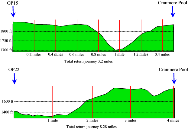
Ok, disregarding the arguments what would these proposals mean? It is proposed that access to the Ring Road be denied from OP22 which effectively would halt all civilian vehicles from going past this point. In this light, take the scenario of somebody who wants to walk to Cranmere Pool. As noted above, at present they would drive down to OP15 and then go to Cranmere Pool which makes for a return walk of 3.2 miles. Under these proposals they would have to park at OP22 and then walk to Cranmere Pool, this makes for a return journey of 8.28 miles (calculated on Memory Map). This means an extra 5.08 miles which in itself doesn’t sound too bad. However, if you compare the profiles of both routes it presents a different picture when the terrain is taken into consideration as can be seen below:
On the 24th of January 2009 a walker noted that from between OP22 and OP15 there were, ‘12 areas where the road needs repairing, 8 of which just required a bucketful of hard core‘. Some local farmers who regularly use the ring road considered that it would probably take about 5 tons of hardcore to fill in the potholes which would cost about £50. Hopefully these comments will put things into some kind of perspective.
Now for the arguments – firstly nobody is asking for a tarmac road akin to a motorway with a Welcome Break services, all that is needed is the potholes filled in so as ‘civilian vehicles’ can gain access along the length of the Ring Road. Secondly, these ideas put forward by the Duchy of Cornwall conveniently tie in with what the Dartmoor National Park Authority were proposing back in 2007. In the management plan of 2007 – 2010 they make the following statement; ‘The wildness and peace of the open moor with extensive dark night skies make Dartmoor stand apart as a place of inspiration and spirituality. These are increasingly rare qualities cherished by local communities and visitors alike‘. They suggest that vehicles using the military roads are aspects that can affect the tranquillity and dark night skies of the open moor. As a means of achieving the tranquillity of the moor it was suggested that, ‘The future public use of military roads on Dartmoor is reviewed‘, see – HERE. It must be remembered that firstly the numbers of cars using the loop road is not of M25 proportions, at best it is only possible to park about 15 cars at OP15 which puts into perspective the numbers of vehicles travelling along the Ring Road. Secondly, the majority of people who drive along the Ring Road are walkers who normally have left the moor by nightfall so this would have very little impact on the, ‘dark night skies’. It is also interesting to note that the huge, heavy military vehicles that regularly trundle up and down the Ring Road are NOT deemed to effect the tranquillity of the open moor or pollute the dark night skies? Surely the question must be asked as to why the military are still going to be allowed to use the Ring Road? Maybe one solution would to add a clause to their lease when it’s next renewed that as it is their vehicles that cause the majority of damage to the road they should be responsible for its upkeep and repair. This also might compensate many users of the moor for the many other inconveniences they cause.
In observation point 3.5 above it is noted that the Ring Road is used by recreational users with, ‘buggies and all-terrain wheelchairs‘ and that a lack of vehicles will make their ‘recreational experience more enjoyable‘. Under these proposals that statement should have an additional statement to the effect of that recreational experience only taking place up to the point of OP22 as I am sure there are not many buggie or wheelchair users that would fancy pushing such things as far as OP15!
So what can be done about these proposals? Firstly everyone with an interest in keeping the Ring Road open should sign the online petition which can be found by following the link opposite. As of the 31st of January 2009 there are 407 signatures on the petition and it needs a lot more, so PLEASE SIGN IT. Secondly it is the Duchy of Cornwall who are now forwarding these proposals and it is HRH Prince Charles who owns the Duchy. In this light maybe a polite letter that explains the consequences of such a closure should be sent to him at: Clarence House, London, SW1A 1BA. Thirdly this issue should be brought to the attention of such organisations as the Ramblers etc.
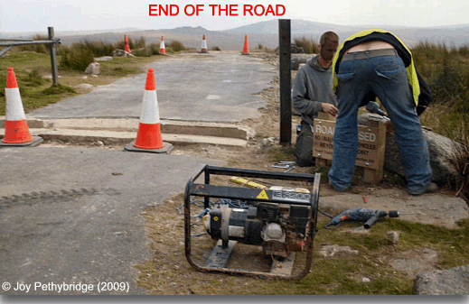
Well as you can see from the above photograph (kindly submitted by Joy Pethybridge), as of the 18th of September 2009 the Ring Road is now officially closed to non-authorised vehicles. Despite a vigorous campaign that included a petition signed by 626 people and numerous letters to all the concerned parties asking them to reconsider their stance many people are now unable to access parts of the north moor.
I think the photograph sums it all up nicely, the cheek of it, what a load of arses!!! Yet again the public have been bullied into submission by dictatorial bodies whose only concern is their own importance and policies. This is now many decades of Dartmoor tradition lost along with a convenient access route to the remoter parts of Dartmoor. I know that there are those who totally agree with this closure and consider that the longer walk will not affect them at all. Yeah right, it is now September and the daylight hours are longer, wait until wintertime when they are not as long and a good number of hours are wasted just in getting to and from places such as Cranmere Pool. Try walking across to Hangingstone or along Black Ridge in the dark and then say this closure hasn’t affected anyone. And I hope those people say a big thank-you to the Dartmoor Rescue Group when they show up.
Next time you are out shopping and you see the ‘Duchy Originals’ food brand just remember who owns it and makes a profit from the range – The Duchy of Cornwall, the very same people who closed the Ring Road. I for one will never be buying anything from that brand again.
The following appears on the Dartmoor Society website: ‘At a meeting of the Executive Committee of The Dartmoor Society on 30 January all members present felt that the Duchy proposal should be supported in principle as it would bring environmental benefits in the wildest sense to this part of wild Dartmoor. However, it is recognised that this view is not shared by all our members – Tom Greeves.’.
As for the Dartmoor National Park Authority, well who could expect anything different, the Mad Hatter strikes again!
There is however one positive note to all this, what with the £15 membership fee that I won’t be paying the Dartmoor Preservation Society any more and the £10 membership fee of the Dartmoor Society plus the £100 odd on Duchy Original products I will be able to afford a new bicycle to get up to OP15.
Reference.
DNPA, 2009. The Loop Road, Online source available at:
http://www.dartmoor-npa.gov.uk/au-authority_reports_for_090109.pdf
DNPA, 2007. Management Plan, Online source available at:
http://www.dartmoor-npa.gov.uk/pl-dnpmgmtplan-text#mp-tranquility
Francis, P. 2002. Okehampton Artillery Range, Exeter: Defence Estates.
Would any of the the ring road be accessible to people with a 4×4 to take the inlaws out or is it completely shut to the public
Hi, yes the road would be accessible with a 4 x 4 but you must get permission from the military to use the road and the wardens regularly patrol it to make sure people aren’t illegally on it. Just say that you want to take your inlaws to wherever and that they are not mobile enough to walk there.
Walked the “western” half of the loop this week, from the fork in the road under Rowtor out to OP15 and back on my way to Cranmere Pool and back. There are no sections that would be impassable to a “light” 4×4 or a family car, nor any barriers beyond the immediate one. Mixed tarmac and fine-grained rubble track.
It’s not a question of being able to drive along it more of what happens if you get caught.
Indeed. Met a farmer coming the other way in one of those little ATV’s but I guess he’s allowed to be there!
Tim, I have to say that I think the further construction of military roads is a potential disaster for Dartmoor. I fear for the last wilderness in the south of England. Military roads should not be allowed to ruin it, regardless of how useful they might be to those with 4×4’s and elderly relatives. Getting the Cranmere pool stamp used to be seen as a test of navigation skills and endurance. Now it can almost be driven to. A great shame.
Hi, sorry I should have updated that webpage – the military road is now closed to the public and access is only allowed up to OP22.