 Legendary Dartmoor The many aspects past and present of Dartmoor


The three military firing ranges encompass much of north Dartmoor and they have done for a very long time. Many of the structures associated with the military’s activities can be classed as ‘archaeological features’ which include target railways, butts, bound stones and the observation posts or OP’s as they are known on the moor. Originally these were granite built ‘bunkers’ where on the Okehampton firing range military personnel could observe any firing activities that were taking place as well as keeping a look-out for any stray animals or ramblers that might be wandering into the line of fire. In 1912 the Western Daily Mercury carried the following report; “Visitors to Dartmoor are often struck with the bomb proof shelters that are scattered over various parts of the Moor for use during military practice by the men who have charge of the targets.. They are roughly built of stout wooden palisades covered with turf and stones, and answered very well years ago, but the increased destructive power of the modern shell renders them unsafe. A few weeks ago a sergeant and four men had a miraculous escape from death. A shell exploded and wrecked the shelter in which they had taken refuge.
In consequence of this all shelters have been reconstructed. Where possible, they have been placed underground, and the roofs have been formed of very thick layers of turf. One of the last actions General Phipps-Hornby V.C, G.C.B., before he relinquished the duties of Camp Commandant, was to witness some very interesting experiments.the gunners in charge of one of the field guns were instructed to shell one of the shelters with shrapnel, an 18 pounder field gun was used and the shell fired was a percussion shrapnel. The gunners fired five rounds at a range of about 800 yards, and each struck the shelter within a radius of less than two feet. Although the aim was so accurate, surprisingly little damage was done by the shell fire. The shell itself did not in fact penetrate four feet of the shelter proof, which is built with a thickness of nearly nine feet, and as a result of the experiment they are considered absolutely safe.”
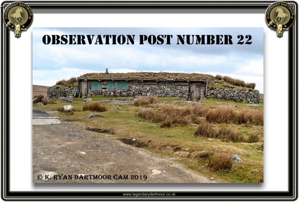
Latterly the modern structures tend to be made of steel and have replaced the old design. Indeed many of the original OP’s have been removed completely. At one time there were around 23 observation posts on Dartmoor, today there are just 7. The rest were removed either by the Ministry of Defence or the National Park Authority because some people considered them an eye-sore and spoilt the natural beauty of the landscape. They are/were a feature of Dartmoor and so it could beg the question as to what constitutes a ‘blot’ on the perceived landscape? It could be argued that around 500 years ago the old stone circles etc were regarded as eyesores and so were removed which today is classed as nothing less than the rape of the heritage of Dartmoor. The map below shows the known locations of the OP’s on the moor, the only one that has proven to be an enigma is OP 18 as its location is unknown. There is also an observation post on Hangingstone Hill but also on the western flank is a derelict structure that is thought to have been a very early observation post or bunker as described above.
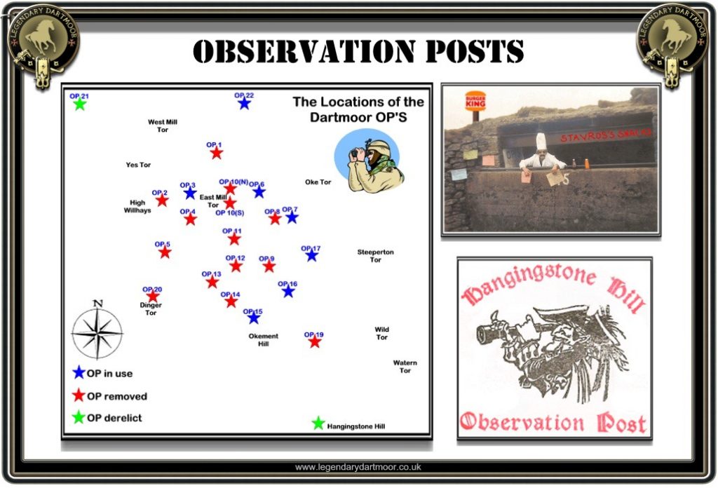
Probably the most famous of all the observation posts is OP15 which is located at the southern-most car-accessible point on the old military road. It was here that many walkers would park before setting out on a ‘trundle’ into the heart of the North Moor. OP15 was an ideal starting point for visiting such places as Cranmere Pool and Fur tor and as opposed to the more traditional starting points will save many miles of walking. Therefore on some days it was not surprising to find the OP surrounded by vehicles. I can remember a few years ago, an elderly letterboxer had parked her car at OP15 and set out for a days boxing. When she returned later that night she found the place devoid of vehicles including her own which meant a distressing four mile walk back down the military road to summon assistance. Sadly thanks to the closure of the military road it is no longer possible to drive to Op15, although having said that if you can make a valid reason such as disability the military will occasionally allow vehicular access.
Taking into consideration how busy OP15 could become, there was once a proposal put forward to use the place as a cafe on days when the military were absent. This very lucrative idea would have also provided a welcome service to the walkers who set off from there. After all if they can have a cafe on top of Snowdon why not at OP15? There has also been the occasional party held at OP15 and in one instance I can recall a pick-up truck loaded with beer crates clanking it’s way up the military road in order to supply the bar, there were even optics fixed to the wall. How many other pubs are there where you can sit on top of the bar and have your drinks handed up? At least at OP15 there were no neighbours to complain about the noise apart from the odd sheep and they soon make themselves scarce.
As with many of Dartmoor’s features the OP’s have been the subject of numerous letterbox stamps and in some cases hidden in or very near the actual structures.
Info about OP 15 is, to say the least outdated. I wonder when you last visited?
Probably a good few years ago, maybe helpful if you explained why!!!
No it isn’t
Public vehicle access is no longer allowed past OP22 or down the western side of the military road past a similar point; therefore, the comments about OP15 being a starting point for walks are well out of date.
Regarding the mysterious OP18, I am going to look at a location in February that might be it.
It has not been possible to drive to OP15 for many years now. The Ring Road is closed to unauthorised vehicles southbound at Row Tor car park and OP 22, where there’s very limited parking.
Thanks for the info, I’ve updated the page now.
OP15 was built into the side of Steeperton tor
That was supposed to be OP18
And is sketched in John Hayward’s Dartmoor 365 as one of the items to find for square D10. (Just rubble now of course).
op18, appears to be just west of steeperton tor, near to the 500 ft elevation ( according to gaia gps satellite topo maps) and os maps,, unless the mappers got it wrong and put 18 where 15 is,, would upload screenshot of gaia map, but it wont let me put it in this box