 Legendary Dartmoor The many aspects past and present of Dartmoor


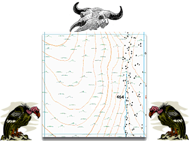
The emptiness of Dartmoor has often been remarked upon, it has been called a wilderness, a waste, a barren land, and many such other descriptives. Those that know the moor probably refute most of those terms but anyone looking at an Ordnance Survey map of Dartmoor could be forgiven for thinking different. Especially if one was to look at grid square – SX 57 85, for this square is unique on Dartmoor as it is the only one not to contain any words. It is devoid of place-names of any sort, there are no feature names – nothing. Just a spot height of 464, a blue line, contour lines, and the symbols for rocks and marsh as can be seen from the extract below:
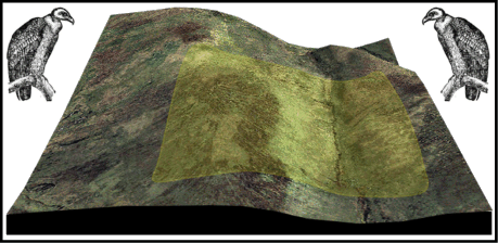
To be perfectly honest this is a rather dramatic claim to fame as it is one brought about by the cartographers and not a topographical phenomenon. Clearly there are landscape features present and it is not as devoid as the map would suggest. The graphic below shows a 3D aerial map of the grid square and clearly shows the huge hill, valley and the river.
The river that flows through the valley is the infant head waters of the Amicombe brook which is flanked on the left by Amicombe Hill and on the right by Great Kneeset. I think it would be fair to describe it as a ‘marshy’ area and it sits within the confines of the firing ranges. Apart from that there is very little else one can say about the wordless tract of ‘No Man’s Land’.
This is quite a unique and interesting spot as in the same valley as the Amicombe Brook sets out to meet the Tavy and Tamar, an unnamed stream heads off in the opposite direction to join the West Okement and the Torridge river system. Just yards apart the water flows to different coasts. Not an easy spot to get to but central to Dartmoor, Devon and the Westcountry peninsular in a lot of ways.