 Legendary Dartmoor The many aspects past and present of Dartmoor

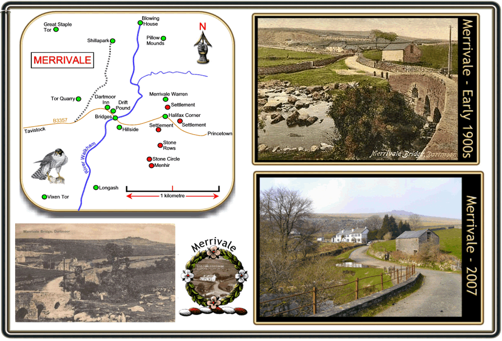
I bet more people have driven through Merrivale without knowing they have done so than those that did. Nobody could have driven from Princetown to Tavistock without wincing at the huge ‘bite’ taken out of the hillside above Merrivale. That gaping wound was known as Tor Quarry and in itself is an entire web page and therefore will not concern us here (too much). The origins of the small hamlet stretch back over the centuries but as a crossing place Merrivale probably existed since the Bronze Age or even earlier. The whole area has been a hive of human activity which ranged from a Bronze Age complex to medieval tinning and later rabbit warrening, quarrying and stone cutting. Alongside these activities throughout the historical periods would have run various agricultural practices of differing types. The crossing point of the river Walkham would have undoubtedly been the first reason for any activity at Merrivale. The first mention of the place in any document (Glover et al, 19992, p.247) is found in the Assize Rolls of 1310 where it appears as Miryfield. In the Court Rolls of 1377 it had mutated to Merifield and in a similar document of 1474 to Merefield. In 1612 the Feet of Fines for Devon lists Merivill and the Recovery Roll of 1752 names Merrifield. It is suggested that the name derives from the old Saxon word myrgõ meaning pleasure or joy and feld meaning open land or plain, thus loosely giving ‘pleasant place’, (Clark Hall, 2004, pp. 244,143). As always there are alternative suggestions of the etymology of the name. William Crossing (1990, p.94) recalls how the area of Bronze Age features on Longash Common was at one time known as the Potato Market or the Plague Market. The latter coming from the tradition that during an outbreak of plague at Tavistock food would be left here for the townsfolk to collect. Accordingly, Spence Bate then came up with the theory that the ‘market’ element derived from the old Cornish word mara which lent itself to Maravale or ‘Market in the Vale’. The market being associated with tin due to the proximity of several blowing houses.
The first substantial bridge appears on Donn’s 1765 map of Devon as Merriville Bridge which is one of the earliest cartographic references (DCRS, 1965, sheet 6b). The red dots on the map below show the location of the numerous Bronze Age features that are on the common about a third of a mile above Merrivale. It would be plausible that anyone approaching from the west would cross the Walkham where today’s bridge spans.
Hemery (1983, p.1044) notes that the original ford was an ancient one and how in later centuries was the northern fording place of the trans-moor Tavistock to Ashburton packhorse track. There is evidence of this old track in the form of a guidestone marked with a ‘T’ and ‘A’ which stands about 200 yards above the bridges – illustration 1. Down through the ages there have in fact been three bridges at Merrivale, the first was a large clapper bridge which was replaced by the redundant relic which stands today, this was constructed in the turnpike days of the 1770’s and is depicted in a painting done by the artist G. H. Jenkins (1870 – 1910) – illustration 2. It is interesting to compare this painting with a photograph of 2007 – illustration 3. On the 18th of May 1879 there was an horrific accident on the bridge, the following newspaper report described the tragedy;
“As a party of five persons from Plymouth were being driven in a waggonette, on arriving above the Merival (sic) Bridge the horses dashed down the declivity with fearful speed, and on arriving at the bottom were hurled over the bridge. The vehicle was smashed to fragments, and the occupants were thrown out. One, who jumped to save himself, fractured his leg, and whilst two others escaped with temporary injuries two of the party Mr. Fareham and Mrs. Mills, lie in a very precarious state.”
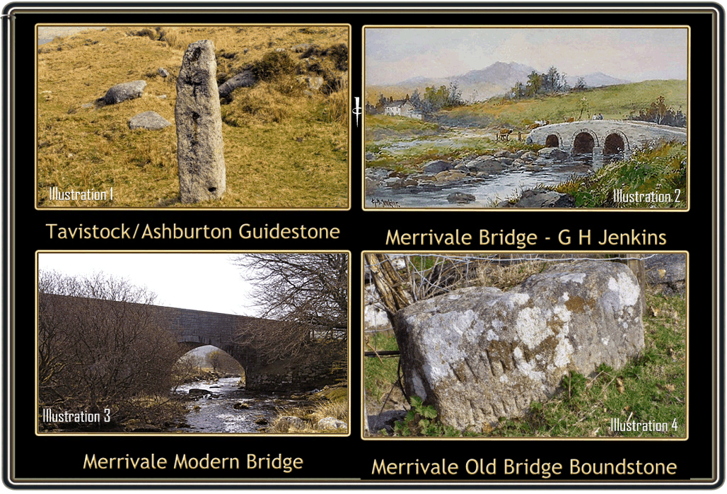
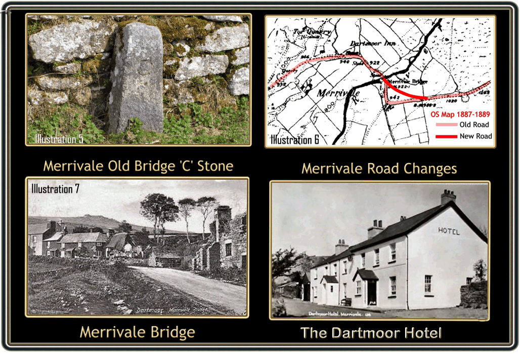
This second bridge is also a point on the Walkhampton and Whitchurch parish bounds a fact denoted by a small boundstone located on the left-hand side of the old bridge – illustration 4. Crossing (p.93) states that it was in fact the river which was the actual boundary between the Walkhampton and Whitchurch commons. It also marks the western edge of the new Dartmoor Forest bounds which were laid down in 1987, (Brewer, 2002, p.188). Whilst banging on about stones there is still one of the two original county stones sitting just above the old bridge under the enclosure wall – see illustration 5. Originally there would have been another on the southern end but this was ‘lost’ when the modern bridge was built. The modern single span bridge which now carries all the traffic was constructed between 1957/8 (Harris, 1992, p.169). It should come as no startling revelation to know that the stone for the bridge came from the conveniently placed Tor Quarry. In a small triangle of land which sits above and between the two bridges is the old drift pound where the ponies were collected after the drift. This has been used right up to modern times and is featured on the Dartmoor, Autumn and Winter documentary made by Brian Carter. Have things changed much? Well have a look at the two pictures above, certainly not in the past century. As far as the bridge is concerned the three posts have gone and some trees have now grown up in the foreground. The old barn still stands but if you look carefully the Dartmoor Inn has changed quite a bit and the hardly discernible row of cottages behind the inn have vanished completely. The postcard above shows the terrace of houses better and the old course of the road before the new bridge was built. Note how little the inn has changed and imagine trying and the white railings on the bridge. This picture demonstrates admirably why the course of the modern road was altered, imagine trying to negotiate those bends on a icy night. The road has been altered at sometime and the wicked ‘S’ bend removed. The early OS map in illustration 6 shows the old road and the modern one that has taken out the bend. But now have a look at illustration 7, this really shows that some drastic changes have taken place over the years. It is evident that on the end of the Dartmoor inn once stood a fairly impressive house. The postcard shows it in ruins but from the look of the chimney it was a substantial building.
The quarry was opened in 1875 by William Duke and after his death his son took over the reigns and expanded the operation. Harris (p.84) estimates that by the early 1900s the quarry employed at least 150 men, hence the building of the row of houses. This would have made Merrivale a bustling hub of industry with the stone being taken to the railway at Tavistock by wagons drawn by teams of horses. In 1903 about 1,600 tons of stone was blasted from the quarry and so with this amount of activity it’s not surprising that there is now a huge, missing chunk of the hillside. The Merrivale stone has been used for peat-pass markers, moorland crosses, and even a war memorial in the Falkland Islands. There is some debate as to whether or not its stone was used in the corbels for London Bridge. Either way all quarrying ceased in the December of 1997 and ended 122 years of continual quarrying.
When you have men involved in heavy work you have men with a thirst and so it’s not surprising that an inn is central to Merrivale. Hemery (p. 1044) says how originally the pub was known as the Merrivale Inn and Quick (1992, pp 28 -31) informs us how the inn was converted from several cottages which once stood on the site. He also notes how the earliest record of there being an inn at Merrivale was in 1841 when according to the census John Harding was the innkeeper. The 1851 census shows him still there with his wife Charlotte and three daughters Elizabeth, Susan and Emma. At the time of the census he had, of all people, a dancing master from Exeter staying with him??? Also at this time there was a family called Easterbrook living at Merrivale, the husband, Robert, was an agricultural labourer and his wife Jane was a toll gate collector. In one of the terrace of cottages lived a family called Rex who somehow managed to cram in the husband and wife, three sons and three daughters aged between 10 and 21 plus a lodger. No surprise that all the males were listed as stone masons. Other families in the row were called Lord, Pote and Lawer. The inn is supposed to boast two ghosts, an unseen spirit called ‘Mary’ and the spectre of a small girl who walks the upstairs corridor. As usual, having catered for the inner man with the inn, his spirit was looked after by the Wesleyan chapel which once stood at Merrivale, not the best of bedfellows I would imagine.
So there we have it, the little hamlet that nearly became a village for a while. There is nothing special about the place but if ever you’re passing why not stop off for a drink at the inn and then have a wander down to the forsaken bridge that at one time took man and beast across the river Walkham.

Brewer, D. 2002 Dartmoor Boundary Markers, Halsgrove Publishing, Tiverton.
Clarke Hall, J. R. 2004 A Concise Anglo-Saxon Dictionary, Cambridge Univ. Press, Toronto.
Crossing, W. 1990 Crossing’s Guide to Dartmoor, Peninsula Press, Newton Abbot.
Devon & Cornwall Record Society, 1965 A map of the County of Devon, Lund, London.
Gover, J. E. B., Mawer, A. & Stenton, F. M. 1992 The Place Names of Devon, English Place-Name Society, Nottingham.
Harris, H. 1992 The Industrial Archaeology of Dartmoor, Peninsula Press, Newton Abbot.
Hemery, E. 1983 High Dartmoor, Hale Publishing, London.
Quick, L. M. (T) 1992 Dartmoor Inns, Devon Books, Exeter.
Fascination to read. I am trying to identify a building within the Merrivale quarry site where my grandmother (Mrs Jewell) once managed a temporary school in 1913-14 for the Foggintor & Merrivale children, whilst their new school was built (at what is now Four Winds car park). It may have been in the chapel shown shown on the 1902-4 map, but my late mother (who had lived there) showed me a walled site elsewhere, further up the slope from Walkham cottages, and now identifiable on Google Earth as having a large tree in its centre. Any ideas?
Fairly accurate disciption of history.Srongly disagree with your comment “There is nothing special about the place ” Merrivale is a beautiful ,magical place full of history ,located on a stunning part of Dartmoor whatever way you approach.Nice pictures though.