 Legendary Dartmoor The many aspects past and present of Dartmoor

Manga, now there’s a name to conjure with, today people usually associate the word with a Japanese genre of comic books but far more interesting are the Manga’s of Dartmoor. You have Manga; Brook, Clapper, Head, Hill, Hole, House, Mill and what this page is about – Manga Rock. It is suggested that all those places take their name from the nearby Mangersford which in turn has derived from the Old English word mangere (Gover et al, 1992, p.9), which means a trader or merchant, (Clark Hall, 2004, p.229) thus giving ‘Trader’s/Merchant’s Ford’. This would indicate that at some time in the distant past there was a moorland route used by traders which crossed the North Teign river at this ford. We certainly know that this crossing place was so called in 1441-2 because it is documented that one John Jeffrey was summoned to answer to the king for mis-appropriating some land between Batworthy and Mangersford, (Worth, 1988, p.341).
A less plausible theory was provided by William Crossing when he noted: ‘This is Manga Rock, ¾ m. S. E. of Watern Tor, manga being a Gaelic word meaning a boundary mark.‘, (1990, p.239). To back up this theory he commented how the rock lies near to the boundary of The Forest of Dartmoor.
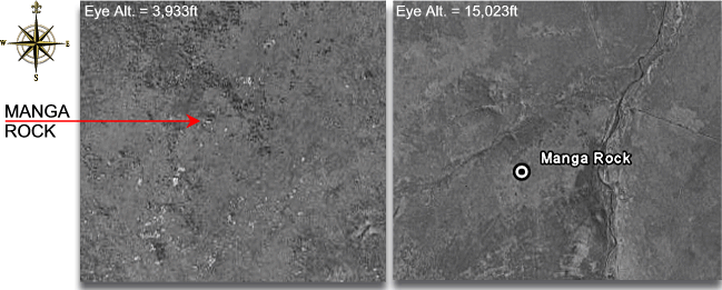
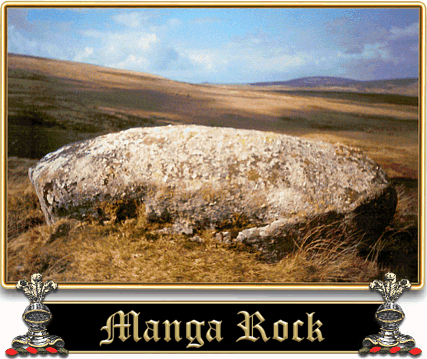
Yes, yes, but what about the rock? Well, actually there is nothing that astounding about Manga Rock, this lump of granite sits on the northern crest of Manga Hill like a huge jelly bean. Some of Dartmoor’s topographical writers, William Crossing being one (1986, p.199), refer to the boulder as ‘Manger Rock’ which almost returns to its original name. Encompassed to the north and west by the Hew Lake (sometimes known as the Wood Hole Stream), and to the east by the North Teign River, Manga Rock surveys all below from its 455.8m vantage point. It can actually be discerned from nearly a mile up in the sky, well 0.744886363636364 of a mile to be exact, which makes it a fairly prominent landscape feature.
For this very fact, Manga Rock has served as a boundary point for several centuries as the incised lettering on its flank will testify. At one time some national bodies considered that Manga Rock was a cairn: ‘Manga Rock – A very tall cairn of loose stones standing some 12-15 feet high. Circular base of stones 70 yards in circumference and 5-6 feet high.’, (Pastscape Record, 2009 – On-line source). There is indeed a cairn located some 760m to the north west of Manga Rock which supposedly was the one that caused the confusion. So, having established that Manga Rock is not a prehistoric cairn and that it is a prominent landscape feature what bounds does it mark? The original Dartmoor Forest boundary of the 1240 perambulation ran from the Thurlstone on Watern Tor and then swerved away just to the east of Manga Rock onto the Longstone on Shoveldon. Back in 1986 there was the suggestion by Brewer and indeed other authors that Manga Rock was indeed on the line of the 1240 Forest boundary when it was referred to as the Heighestone, he notes: ‘Heighestone (Hingeston or Highstone, probably Manga Rock).’, (1986, p.1). This misconception was clarified in his book of 2004 when the ‘Heighestone’ was regarded as ‘The Longstone’ which stands on Shoveldon some 2.5 kilometres east of Manga Rock.
Abutting onto parts of this 1240 Forest boundary is the parish line of Gidleigh and according to Brewer’s map (2002, p.65) this boundary line was extended slightly in favour of Gidleigh Parish to include Manga Rock in the 1800s although since the 1600s the parishioners maintained that this was where the boundary should be. Another dispute arose in the early 1800s when the owners of nearby Teignhead Farm, messrs. Crawford and Fleming, attempted to enclose some of the Gidleigh Commoners land. In order to do this they employed a William Rogers to oversee the construction of the newtake wall. Once the work had been finished the good folk from Gidleigh immediately went out and demolished the offending wall. At an inquiry of 1842 William Rogers for some strange reason decided to testify in support of the Gidleigh folk and confessed that after his wall had been knocked down he had attempted to remove some of the Gidleigh Parish bound stones, in particular:
‘Manger Stone was inside our enclosure about 50 or 60 yards. At Manger Stone I found an upright rock marked ‘G’ (representing Gidleigh Parish). I obliterated the ‘G’ to lead Gidley people astray. Mr Crawford ordered me to obliterate the mark. I knocked out the letter with a pick. I was annoyed with the Gidley folk for knocking down the wall.‘, (Brewer, p.64).
This suggests that in the 1800s there was in fact another boundary stone standing near to Manga Rock which Rogers ‘obliterated’. Either way, it won’t happen again because the letters ‘GP’ are now firmly emblazoned on the north side of Manga Rock for all to see.
Brewer, D. 2002. Dartmoor Boundary Markers,Tiverton: Halsgrove Publishing.
Brewer, D. 1986. Boundary Markers on and Around Dartmoor, Exeter: Devon Books..
Clark Hall, J. R. 2004. A Concise Anglo-Saxon Dictionary, London: University of Toronto.
Crossing, W. 1990. Crossing’s Guide to Dartmoor, Newton Abbot: Peninsula Press.
Crossing, W. 1986. Gems in a Granite Setting, Exeter: Devon Books.
Gover, J. E. B., Mawer, A. & Stenton, F.M. 1992 The Place-Names of Devon. Nottingham; English Place-Name Society.
Worth, R. H. 1988. Worth’s Dartmoor, Newton Abbot: David & Charles.