 Legendary Dartmoor The many aspects past and present of Dartmoor

“Lydford Bridge has been compared to the Devil’s Bridge in Cardiganshire. It spans a dark chasm through which struggles the almost invisible river, seventy feet below. Than this romantic gorge no fairer spot exists in the West Country, and few more alarming to a head other than strong. To within a few feet of the boiling, eddying stream the precipice is clothed with ferns and underwood, the delicate tracery of branches far up against the sky almost concealing the bridge from view. The rocks are black with perpetual moisture, and slippery as glass under the ceaseless friction to which they are subjected by the angry river. Nothwithstanding occasional protection in the shape of a handrail, the timid are recommended not to approach the bottom of the cleft , as a false step might very well prove fatal.” – J. Ll. W. Page, p.113.
Lydford Gorge – take a balmy May day, blue skies and a gentle breeze and you have all the essential ingredients for an unforgettable walk. Virtually every sense will be provided with a feast of kingly proportions – sights, smells, sounds and touch are all adequately catered for in Lydford Gorge.
The strata of rocks that form Lydford Gorge were formed by earth movements which took place some two hundred and eighty million years ago when they were twisted and folded into what can be seen today. There are three main rock formations that lie within the gorge; the Lydford, Liddaton and the White Lady which is the deepest of the three. The Lydford formation is a fine metamorphic rock which varies in colour from from dark grey to brown and contains bands of whitish mica. The Liddaton formation is made up of around 100 metres of fine grained metamorphic rock that is dark grey to black in colour along with the odd limestone outcrop. The White Lady formation is made up of drastically deformed slates, marbles along with thin bands of quartzite.
Approximately ten thousand years ago the melt waters from the last ice age began to slowly erode a path down through the rock Strata forming the gorge. This responsibility was later taken on by the River Lyd who continued (and continues) to erode and cut its way down through the rock. Today the most dramatic examples of the erosion are the Tunnels Falls and Devil’s Cauldron where the river has formed narrow channels and seething basins in which the waters froth and foam. Incidentally in 1249 the river Lyd was documented as being – aqua de Lide which basically translates as the ‘noisy or loud stream, a most apt name especially when standing near the Devil’s Cauldron.
The popularity of Lydford Gorge began back in the late seventeen hundreds when due to the Napoleaonic wars and conflicts the ‘Grand Tour’ of the upper classes became redundant. This meant that those aristocratic eyes turn inward to what Britain could provide. Around the same time William Gilpin introduced his theory of the ‘Picturesque’ which in a nutshell was the appreciation of rural and rustic landscapes which encompassed dramatic scenery and landscape features. These two factors meant that those in search of the picturesque came to visit Lydford Gorge, amongst the many was William Gilpin himself. Writing in 1798 he noted the following of the river and gorge:
“This River (The Lyd) rises about three or four miles above Lidford, on the edge of Dartmore, and flowing through a barren plain, finds a small rocky barrier, through which it has, in course of ages, worn a whimsical passage from the check it meets with here, it falls about thirty feet into a small dell, which was not represented to us as a scene of much beauty. But a little farther the banks rise on each side; vegetation riots, the stream descends by a winding and rapid course; and the skreens, though small, are often beautifully adorned with wood and rock. By this time the river approaches the bridge, where it is lost in the narrowness of the channel, and as I have just observed, becomes almost subterranean.”, Gilpin, pp. 184 -185.
And so began the steady stream of visitors to Lydford Gorge, the ‘picturesque peekers’, artists, poets, writers and other such folk. Before 1875 Lydford Gorge was only approachable by road or on foot but in that year Lydford railway station opened making it much easier for folk to visit the gorge. It also meant that the lower social classes could also afford the journey often making day trips from Exeter, Plymouth etc. Now in the protective custody of the National Trust the gorge still attracts numerous visitors from all walks of life and continents. Today the whole of the gorge is owned by the National Trust who acquired the gorge from the Radford family in 1947. Due to its unique floral and faunal habitats the entire gorge is classified as an SSSI (Site of Special Scientific Interest). The 36.23 hectare site consists of mainly ancient oak and hazel woods that are home to various typed of uncommon mosses and bryophytes. The gorge is also a haunt of many species of birds such as ravens, buzzards and dippers to mention but a few. There are also reports of otters frequenting the many pools that can be found along the gorges’ length.
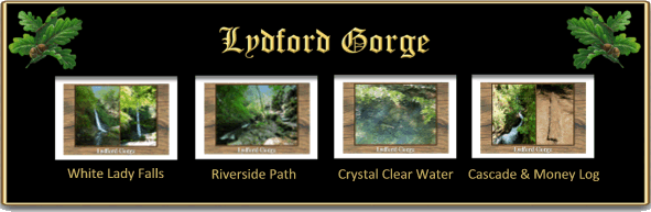
It was a glorious May day when we visited the gorge and after some heavy National Trust recruiting efforts finally managed to start the walk. Dotted all around the trail are various wooden sculptures and the first of many to greet us were two menacing spiders. Strolling deeper into the gorge the thick bluebell carpets began to decorate each side of the path, their perfumed scent blending with the heady aroma of wild garlic. All around the birds were merrily singing in the lofty broadleaf canopy overhead to the background accompaniment of the rivers flowing way below. On the left-hand bank of the path a small granite post appeared tightly snuggled into the flora. This was the first of two we found, one marked with a simple ‘S’ and the other with an reversed ‘S’. To this day I have no idea what these stones represent and unfortunately neither had any of the staff working in the visitor centre, in fact they were not even aware of their existence. Following on from this, a few days later I received the following email from Robin Vane:
“Regarding the stones at Lydford Gorge , we came across one many years ago, didn’t know what it was for, then found it in Dave Brewer Dartmoor Boundary Markers page 198. He believes they are for the Spooner family. Like many things we didn’t get back to look for the second stone but last March at long last went and found the other stone we cleared them both as they were covered in moss. We informed the staff at the information office who seemed very interested, looked at the photos and said they would pass on the information. Sadly looks like they didn’t.”
Maybe it would be an idea for the National Trust to make a question and answer book in which such queries could be logged, answered where possible and was kept at the front desk?

People say that; “money does not grow on tree,” but in Lydford Gorge it not only grows on trees but on mushrooms. Just in between the two boundstones we found a wooden sculpted mushroom that was literally studded with coins. So much so that it was difficult to find a spot where we could add to the collection but somehow perseverance prevailed and the hoard received another deposit. Roughly halfway along the trail the first cascade tumbled down into the gorge which were a taster of much grander things to come. Virtually all of the left-hand side of the gorse was smothered with a pungent carpet of wild garlic. The heady aroma brought to mind a sizzling steak, field mushrooms and chips but sadly neither were to hand.

After a roller coaster of ups and downs the outward trail ended at the lower National Trust entrance. It is here that one first gets an inkling that the White Lady Falls are not far away. As you descend the steep zig-zag steps the thunder of the cascading water becomes a roar and on this occasion it is after a dry period so heaven knows what it would be like in full spate? The waters of the falls belong to the River Burn which rises about a kilometre away on Black Down. Supposedly the falls are haunted by a spectral figure of the ‘White Lady’ who appears when somebody is drowning in the river and goes to their rescue. For much more detail on the White Lady Falls click – HERE and HERE for some poetry. It is at this point the trail crosses the river and makes its way back up the gorge along what in places is a narrow stone path. It is remarkable how crystal clear the waters are which fortunately allows the occasional glimpse of the many trout living in them (as can be seen in the photograph below). As progression is made back up the gorge numerous small cascades can be seen along with the Money Tree, again heavily studded with coins. In fact so much so that people have started to use the wooden bank supports to deposit their ‘offerings‘.
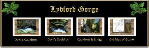
Near the top end of the trail is what appears to be gated mine adit but on seeing this it does remind one of the fabled Gubbins’ who supposedly made their home in the gorge. They were a gang of outlaws led by one Roger Rowle and were renown for robbing, sheep stealing and generally making life unpleasant for anyone who came across them. Again, for much more detail click – HERE. If the White Lady Falls are the main attraction at the bottom of the gorge’s trail then the Devil’s Cauldron is the star of the top end. It is here that the river Lyd crashes through a dark and narrow defile, bubbling and boiling the seething angry waters truly suggest a demonic association. William Crossing made the following observations of the Devil’s Cauldron:
“It is at this higher point that the Lyd issues from that deep and dark fissure so unlike anything seen on the other rivers of the moor. Into this the sunshine never penetrates, and in the gloom the happy little stream loses her smile for a time. By means of a path carried along the side of the chasm and protected where necessary by a hand rail, the visitor may make his way through it. On each side rise walls of rock; overhead the trees hide the sky, while below the stream is seen forcing its way through the narrow cleft. The lower parts of the dark precipices wetted with spray, are smooth and shining, while higher up their sides ferns and other plants find a holding on narrow ledges.”, p.182.
It is also at this point that one can look up and see the famous Lydford Bridge which in the realms local folklore has several tales attached to it. Amongst these is the ‘Lydford Leap’ a heroic leap taken by a horse, for more detail click – HERE. The bridge was also the scene of a tragic suicide, for more detail click HERE.
All in all a splendid walk on which we saw countless species of flowers, trees, fish and birds, sadly there was no sign of otters but one cannot expect everything or be two greedy.

In this age of Health and Safety much has been done to ensure the well-being of visitors but when one looks at some of the old photographs this certainly was not the case. The early routes around the gorge were perilous to say the least with scant provision of hand rails etc and in some cases they would literally take their lives in their hands. Today the route of the trail operates in places on a one way system due to the fact that some of the paths are so narrow two people coming in opposite directions could not pass. Certainly the path leading up from the lower entrance is not only narrow but could be extremely slippery when wet. It is advisable to wear stout footwear with a good grip to avoid any slips or falls. In places there are some steepish climbs so some degree of fitness is required along with good mobility.

Crossing, W. 1987. Gems in a Granite Setting. Exeter: Devon Books
Gilpin, W. 1798. Observations on the Western Parts of England. London: Cadell & Davies
Was there decades ago, and not much has changed. Regretfully not in England now (Canada) but so much history!