 Legendary Dartmoor The many aspects past and present of Dartmoor

Lustleigh could be described as the quintessential moorland village, there are thatched cottages, an old church, a time honoured inn and the obligatory tea rooms. This small village is probably best know for its cleave which attracts many visitors and walkers who enjoy the beautiful woodland walks. In a sad way Lustleigh seems to have been overtaken by these modern times, try parking on a summer’s day and watch the narrow streets desperately try to accommodate the relentless flow of traffic. Many say that it was the coming of the railway in 1866 that changed forever the lives of the Lustleigh folk. The attraction of the cleave and picturesque brought many tourists who as the years passed also began to arrive in motor cars and gradually things began to get busy.
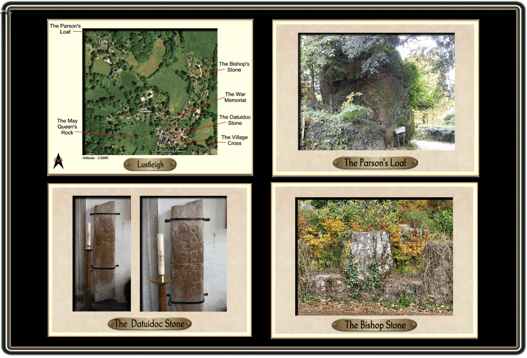
There is no doubt that the local community are proud of their heritage and much goes on to ensure that the old village traditions survive in one form or another. And who can blame them, the history of the settlement stretches way back to the time when men hunted with flint tipped arrows and lived in stone huts. In fact there is so much history attached to Lustleigh that a web page cannot do it justice, this task I shall leave to the various books that have been printed and are listed at the bottom of this page. The purpose of this page is to focus on six stone objects that can be found around the village which will hopefully give a small insight to the village’s past and present – see pic. 1. In a way it’s a timeline in stone, so park up, buy a guide book and just enjoy a steady amble around the village and then enjoy a Devon cream tea.
To set the scene it may be worth looking at the origins of the village’s name – Lustleigh. It has been suggested that this actually comes from the late Old English language and consists of two elements, one being personal and the other descriptive. The easiest part to establish is the descriptive word – leah which means ‘a piece of ground, meadow or clearing’ and has mutated into the ‘leigh’ part of the name. The personal element may derive from the surname of Lĕofgiest or Luvesta which in fact was a nickname meaning ‘dearest one’. Therefore if you want to take the name to the extreme it means the ‘ground belonging to the dearest one’, if not the less prosaic interpretation would be ‘Lĕofgiest or Luvesta’s ground’, (Glover et al, 1998, p.480). They also list the earliest documentary mention of Lustleigh as being in the Book of Fees listed in 1242 as Leustlegh. However the consensus of opinion today points to the famous tome of the Domesday Book where in 1086 the manor of Lustleigh appears as Sutrewarde which is an old Saxon word meaning ‘South of the Wood’. This manor is listed in the so-called book of reckoning as being owned by the lord Ansgar who held the lands prior to the Norman conquest as can be seen from the extract below:
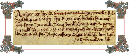
The translation reads as follows: “Ansgar holds SUTREWORDE from Walter. Esger held it TRE. and it paid geld for 1 virgate of land. There is land for 12 ploughs. In demesne are 2 ploughs. and 5 slaves; and 11 villans and 14 bordars with 8 ploughs, and 5 swineherds rendering 61 pigs, and 5 bee-keepers rendering 7 sesters of honey. There are 23 acres of meadow, and 10 furlongs of pasture. woodland 1 league long and half broad. Formerly, as now worth £7″, (Digital Domesday).
The most noteworthy entry in this extract is the mention of bee-keepers, it is thought that in the whole of the Domesday Book there are very few such entries which suggests that bees were an important commodity for the village.
Right, having given a very brief background of Lustleigh’s origins it’s time to get rocking. The first stone to visit is the huge great boulder which is situated up Mapstone Hill, sadly today it is very overgrown with ivy and other such vegetation but this has not always been the case as the picture in the Dartmoor Archive shows – see HERE and see below. Today, although not marked on the OS map the boulder is known as ‘The Parson’s Loaf’ but on both the 1886 and 1888 maps it was recorded as .’The Parson’s Brown Loaf’. The latter name was still in use by 1905 as William Crossing testifies:
“Another monument, but one which Nature erected, is also to be seen not far from this secluded village. This is the Map Stone or Parson’s Brown Loaf, situated, appropriately enough, near the rectory. How it came to bear an appellation so suggestive of the giving of a stone in the place of bread we are unable to say“, (1987, p.76).
If you fly like a crow for a mile and a half in an easterly direction across the cleave you will find by the river another rock at the old Foxworthy Mill known as ‘The Round of Beef’. Could this be the rest of the parson’s lunch or was there some propensity for the locals to name such landmarks after food? As Crossing mentions the alternative name for the rock is ‘The Mapstone’ . This name was recorded in the assize rolls of 1249 as Mattepaneston. Again, good old Gover and friends come up with an interpretation which suggest three elements to the name. The first being a personal one for Matte, this deriving from the Old English name – Mæo, this then derived from the Old English word – Mægo which means a ‘virgin’, (Clark Hall, 2004, p.225). The second element pan is suggested to describe the shape of the rock and the ston element clearly refers to the stone. So we have up to now the ‘shaped rock of the virgin’. I would like to extend this theory, there are several other ‘pans’ on Dartmoor and each one refers to a naturally formed basin that occurs on a rock’s surface, often these fill up with water, one example being – Mis Tor Pan. At one time it was thought that these ‘pans’ were used by the Druids to conduct their mystical rites and in some cases as a receptacle for blood sacrifices. It is a known fact that such a ‘pan’ exists on top of the Mapstone therefore another interpretation of the name could be the ‘virgin’s pan stone’ which would possibly give the stone some mystical attributes, maybe the ancients sacrificed virgins here? The Lustleigh guide book of 1979 (p. 8) considers that when the old farm of Mapstone (which stands opposite the boulder) came into use as the rectory the old name that was so suggestive of paganism was changed to a more Christian one, ergo, The Parson’s Brown Loaf.
A short trip down the hill will bring us back to the village centre and the old church. The fact that the church stands in an oval enclosure is suggestive of their being some sort of church here since early times. This notion is confirmed by a large slab of stone which is mounted to the inside of the church wall – the Datuidoc Stone. Either way, with both the stone and the plan of the churchyard there can be no question that Lustleigh at one time had an early burial ground which later developed into a lann.
Therefore this would possibly date the Datuidoc stone to the pre-Christian era of Lustleigh when it would have acted as a grave marker, this has been tentatively dated to a burial of between AD550 and AD620 despite some suggestions that it’s Roman.
Whilst in the church don’t try looking for a church cat, Page (1895, p.226) tells the story of how many years ago a man entered the church with a pack of playing cards in his pocket. Immediately the Devil appeared and threatened to take him down to hell unless the unfortunate wretch could make a suitable offering befitting the Prince of Darkness. The man desperately looked around the church but saw nothing, he then went outside and saw the church cat which was quickly dispatched and tentatively handed over. Much to his relief the Devil accepted the sacrifice and vanished in a cloud of blue smoke and sulphur.
From the church the next destination on the rocky road is a huge, vegetation covered stone which stands on the corner of the road that enters the old village known as the Bishop’s Stone, , the history of which can be found at this link – Bishop’s Stone (the Dartmoor Archive clearly shows what a difference 10 years of growth can make – see photo HERE.)

From the Bishop’s Stone the rocky timeline goes back into the village to visit the May Queen’s Rock which sits in an orchard just down from the post office, it also takes us forward a good 700 years. In the 1300s the great plague swept across the country but by good fortune passed Lustleigh by leaving all the villagers unscathed. Tradition has it that after the epidemic had died away it was decided to celebrate the fact that nobody fell victim to the plague’s ravages by holding festivities on May Day However, time passes quickly as do memories and like many other places in the country the popularity of the May Day celebrations began to wain until eventually the tradition died out. But in the early 1900s Cecil Torr decided to resurrect the tradition and had the following to say about it:
“There is a May-day festival here for which I am responsible. There used to be dancing around the May-pole at the flower-show and other festivals, but none upon May-day itself and I put an end to that anomaly“, (p.58).
As part of these celebrations an elected May Queen was crowned amidst much pomp and ceremony, all this took place on the hillside above Wreyland. Part of the tradition was that each year the May Queen had her name carved on a granite boulder which began in 1905 with Mabel Bunclarke. In 1954 the ceremony was moved to its present location in the Town Orchard where another large boulder served as the May Queen’s Rock and had all the subsequent names carved upon it. To mark the 2000 millennium year a splendid stone seat was erected on top of the May Queen’s Rock to serve as her throne – (see pic. 6). Another stone in the Town Orchard commemorates the fact that in March 1966 the orchard was kindly given to the village by its owner, Mrs M. E. Bennett.
From the Town Orchard it will now be possible to walk back into the centre of Lustleigh and travel forward a few years to sometime after 1904 to see the village cross. In fact this cross is not a cross. it is a memorial to a one time rector of Lustleigh, namely the grandly named Harry Tudor. An inscription on the cross reads, “In pious memory of Harry Tudor, Rector of this Parish“. He served his parish between the years of 1888 and 1904 which means it was after the latter date that the cross was erected. This is one of the larger village crosses on Dartmoor which meant when I was researching my book it was impossible to get its vital statistics without shinning up its shaft. But there can be no argument that set against its backdrop of thatched cottages it makes a splendid focal point for the village – (see pic. 7).
The last port of call on this rocky tour is back up the the war memorial which sits at the bottom of Mapstone Hill. I think without doubt this has to be the finest village war memorial on Dartmoor. Clearly the villagers wanted to remember their dead and give them a befitting monument. The land it sits upon was given by Major-General W. J. Fawcett and the actual monument was designed and its construction overseen by Colonel A. S. Dunlop. In 1922 there was a dedication ceremony held for the memorial at which the Bishop of Exeter officiated along with General Sir Alexander J. Godley who unveiled the stone. The Dartmoor Archive holds a photograph of this very ceremony and can be seen – HERE. The memorial records the fact that tragically 19 Lustleigh men lost their lives overseas during World War I and three others died whilst serving at home. The Second Wold War claimed the lives of 10 local men.
This then concludes the stony walk but is by no means all there is to see in and around Lustleigh, it’s easy to spend the whole day here, especially in the quieter months, when times seems to stand still or if anything go backwards.

Brewer, D. 2002 Dartmoor Boundary Markers, Halsgrove Publishing, Tiverton.
Clark Hall, J. R. 2004 A Concise Anglo-Saxon Dictionary, Cambridge University, Canada.
Crossing, W. 1987 Gems in a Granite Setting, Devon Books, Exeter.
Crossing, W. 1987(a) The Ancient Stone Crosses of Dartmoor, Devon Books, Exeter.
Gover, J. E. B., Mawer, A. & Stenton, F. M. 1992 The Place Names of Devon, English Place-Name Society, Nottingham.
Torr, C. 1970 Small Talk at Wreyland, Adams & Dart, Bath.
Other Sources.
Digital Domesday CD-Rom, 2004 – Devonshire, Alecto Historical Editions.
Further Reading.
Amery et al (ed). 1997 A Guide to the Parish of Lustleigh, Lustleigh Parish Council, Lustleigh.
Barber, C. 1998 Around & About Lustleigh, Obelisk Publications, Exeter.
Crowdy, J. 2001 The Book of Lustleigh, Halsgrove Publications, Tiverton.
Russell-Welch, R. 1978 Lustleigh – Devon, Lustleigh Parish Council, Lustleigh.