 Legendary Dartmoor The many aspects past and present of Dartmoor

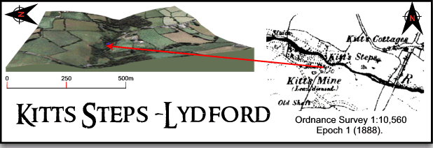
Just above the village of Lydford lies Kitts Steps which is where the river Lyd tumbles over a waterfall before entering the famous Lydford Gorge. The actual term steps is used to describe a crossing place on a river that consists of large granite boulders that act as stepping stones. Over the years there have been many place names attached to the location and the features that can be found there. In theory there are the actual falls, a supposed crossing place and a ‘hole‘ where the river runs through a narrow part of the valley which should mean that there should be three seperate descriptive place name elements. But there aren’t as many of the names refer to the whole location and not each individual feature. Just to confuse things even more there is in fact a similar place name on the East Dart river called Kit Steps which is on the high moor about 6 miles to the south east. But whatever you would like to call it Kitts Steps is one of those hidden gems of Dartmoor that is shrouded in legend and beauty, so let’s start with the legend first…
One of the earliest references to the falls come from Williams in 1804, (pp.81 – 82), when he simply remarks that whilst attempting to cross the river, a market woman and her pony were swept away by the current. The woman was drowned as a result of the incident and her horse was trapped by the crooks on its back between some rocks. The location at this time was referred to as ‘Kate’s Fall’ a name which over time and tradition was to change many times along with the version of events. In 1846 Rachel Evans, (p.179), serves a sparse servings of the legend of which is just the bare bones of the tale that are presented, she relates how a woman called Catherine travelled to a village feast at Lydford in order to sell her wares. Whether she simply had a busy day or became too involved with the ‘spirit’ of the feast nobody knows. What is known is that it did not take her long to fall asleep whilst riding home on her pony, a snooze that was rudely interrupted at the falls. She suddenly woke to find herself hanging from the crooks of her pack over the roaring waters of the river Lyd, the pony was somewhere underneath floundering in the current. It is hard to believe, but tradition has it that this was how she spent the night, clinging precariously to the crooks admist the swirling torrent. In the morning her husband went in search of his missing wife and found her at the steps where with the aid of a rope he managed to save her from a watery demise.
A different and more tragic version of the tale was related by Mrs Bray in 1833, here a woman called Catherine or Kitty was returning from Okehampton market where she had been to sell her produce. On the return trip her route took her to the falls where she found the river Lyd in spate. Unwisely she attempted a crossing and both her and the pony were swept away in the turbulent current, she was drowned but the pony was later found grazing on a nearby bank, (Bray, pp. 353 -354).
Ruth St. Ledger-Gordon, (1972, p.86) takes the event a step further insomuch as she relates how the ghost of, ‘old Kitty’ is said to haunt to pool which lies at the bottom of the falls. The spectre has been reported as wearing a red kerchief although of what relevance that is I know not.
Some authors have over the centuries caused some confusion as to the location of this event insomuch as they have attributed it to occurring at the White Lady Falls further on down the river.
Which ever version of the tale you care to favour it has been supposed this is how the location got its name but again over the years this has varied greatly. In 1764 it was referred to as ‘Kate’s Fall’ and then over the years variously as ‘Kate’s Falls, ‘Kitt Falls’, ‘Kitt’s Falls, Kitt Steps, Kitt’s Steps and even Kitt’s Hole. In 1826 an artist did an engraving of the falls and called them ‘Gate’s Falls’, this clearly was a result of misunderstanding the dialect pronunciation of ‘Kate’s Fall’. By the end of the 1800s the Ordnance Survey were labelling the location as Kitt’s Steps, a name which remained until they stopped marking it on their maps at all. Another theory as to the origins of the place name is that it does not refer to a personal name at all but is a corruption of the local term skit which means ‘scatter’. This alludes to the scatter of rocks that occur on and around the falls, if this is the case then it totally negates the legend theory.
As with the White Lady Falls further down the Lydford Gorge, Kitts Steps was a favourite location for those in search of the picturesque. Not only did these falls provide a rugged natural beauty but by the 1830s the landscape also contained scenes of industrial activity in the form of nearby lead mine. In the early 1800s, William Gilpin, the founder of the Picturesque Movement visited the Lydford area and from his description of the course of the river Lyd was not too impressed by what he saw at Kitt Steps, (1808, pp. 183 -184). He simply noted with apparent disappointment that:
‘This river rises about three or four miles above Lidford, on the edge of Dartmore, and flowing through a barren plain, finds a small rocky barrier, through which it has, in a course of ages, worn a whimsical passage. As it issues from the check it meets with here, it falls about thirty two feet into a small dell, which was not represented to us as a scene of much beauty.,
The scene has been described by Mrs Bray:
‘I was afraid I should find the scene much injured by the mine ; but I have little hesitation in saying that I think it an improvement, at least in point of picturesque effect. Over the river in the foreground is thrown a singular kind of bridge, formed I imagine, of part of an old wheel, or whim. Beyond it, at a little distance, is seen the main fall of the cataract ; and considerably above it, a branch of the river is conveyed by a wooden aqueduct, supported upon rough poles, with the water dropping in filaments from several parts of it, to an overshot wheel opposite. The accompanying machinery over the shaft, with the flag-staff on the highest summit at a distance, considerably diversify the scene ; and, as the mine is in its infancy, the heaps of rubbish, which it is too frequently accompanied, have not yet accumulated so as to offend the eye.
In order to form a correct idea of this cascade, it will be necessary to take a view of it from the top. The rock appears, by some convulsion of nature, to be slit into two fissures, through only one of which the water flowed till lately, part of it being now carried through the other for the purpose of working the mine. From the centre mass, which is about twenty feet high, two or three large pieces of the rock, as may be seen from the incumbent part, have fallen into the fissure, and have entirely covered it ; which no doubt gave origin to the idea that ‘the water runs some way underground,’ and, when overhung with brushwood, which is generally the case, the deception would be more still complete. I am convinced that this channel could never have been entirely formed by ‘the irresistible force of the waters,’ as the surface on either side is flat and almost perpendicular. The rock is of a very slaty nature with its direction by the convulsion before alluded to, dipping southward at an angle of about forty five degrees. The chasm or fissure, through which the river begins to fall, at a depth of about five and twenty feet, is about ten across. Through it the machinery of the mine below, with the water that is conveyed to it falling over some rough rocks, and forming a kind of secondary cascade, is a pleasing object ; whilst through the other chasm are seen at a distance the church and castle of Lidford. Viewed from below, the water seems in the centre of the chasm to rush from beneath a rock, which no doubt occasioned it to be called Kitt’s Hole. After three or four obstructions in its course, it leaps over a ledge of rock in a perpendicular fall, but not more than twelve or fourteen feet in height, whilst the water in the basin below is about eleven feet deep.‘, (Bray, 1838, pp. 354 – 356).
It has been suggested that the mine referred to above was a mine originally called Wheal Reform and that work began there in the 1840s. Hamilton Jenkin relates how its purpose was to extract lead from a lode which ran from north to south across the river. An adit along with three shafts were driven into the lode with the most northerly shaft being the deepest at 40 fathoms, (2005, p.86).
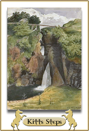
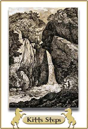
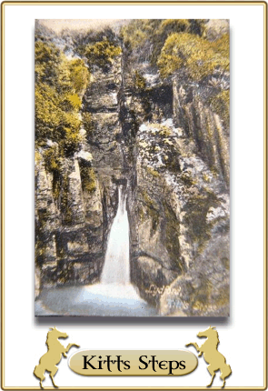
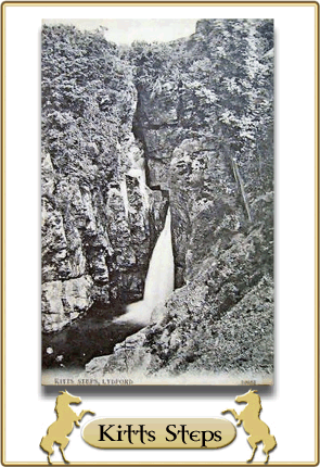
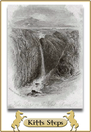
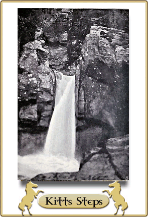
Below are various paintings, engravings and photographs that over the centuries artists have produced, some border on the wildly imaginative and dramatically
picturesque whilst others are a true representation:
|
|
|
|
|
|
|
|
|
|
|
|


Reference.
Bray, E. 1838. Traditions, Legends, Superstitions and Sketches of Devonshire…, London: John Murray.
Evans, R. 1846. Homes Scenes or Tavistock and its Vicinity, London: Simpkin and Marshall.
Gilpin, W. 1808. Observations on the Western Parts of England, London: Cadell & Davies.
Hamilton Jenkin, A. K. 2005.Mines of Devon, Ashbourne: Landmark Publishing.
Luckombe, P. 1764. The Beauties of England, London: Davis & Reymers.
St. Ledger-Gordon, R. 1972. The Witchcraft and Folklore of Dartmoor, Wakefield: E. P. Publishing Ltd.
Williams, T. H. 1804. Picturesque Excursions in Devon and Cornwall, London: J. Murray
I have found another reference to the legend, which gives a slightly different angle to it.
The book Home Scenes; or Tavistock and its Vicinity, published in 1846 and available via Google Books, includes the following passage, in which the author recalls how in former days he had spent time with a friend in the vicinity of Lydford, and had visted Kitt’s Steps, a waterfall:
We amused ourselves in the evening by composing a Tam O’Shanter edition of the tradition belonging to Kitt’s steps: there was a true and particular description of the birth, parentage and education of Mistress Catherine, founded on the true story of an original in our neighbourhood by the name of Kitty Lampiere; then came her riding to the village feast; and her return on her old mare, seated upon the crooks which had conveyed her goods to the fair. Lastly, the catastrophe of Kitty’s falling asleep, and awakening to find herself suspended by the crooks over “the steps”, with the water of the Lyd roaring in her ears, and poor Dobbin floundering in the depths beneath. We imagined the horror and consternation of the poor woman as she sat perched aloft the live-long night; the ludicrous surprise of her husband at finding poor Kitty in such a dubious situation; her being hoisted up by ropes, and returning hearty thanks for such a “wonderful escape”.
The reason I found this passage is that I am descended from John Lampeer of Tavistock, and was trying to trace the name. I found the marriage of a William Lampier to Catherine Coram, in Tavistock in 1777. It made me wonder whether she is the Kitty Lampiere referred to in the passage above.
I hope this is of interest.
Thanks for the info.
Hi! This place is amazing. Is it on private land that it has disappeared from the maps? I stuck to the footpath and it’s got a gate with no “private” nor “keep out”. The path went to the river only a few metres so just wondering what is the public status ?
This place is on private land and is not accessible to the public.
How annoying. Well they could put some signs up as it’s only a few metres from the PF. Well there was no one around to ask for permission. Only wanted to take some pics of the waterfall. I wonder what part of the river is NOT on private land? What I am getting at is, can it be viewed from afar. Shame it is on private land as this is one of the best waterfalls I have ever seen.