 Legendary Dartmoor The many aspects past and present of Dartmoor

If a Dartmoor tor could reveal what it has seen down through the millennia then Kestor surely would have some stories to tell. Its rocky outcrops survey directly over a ancient landscape of ritual monuments and old stone huts. In previous centuries some early antiquarians believed that the tor was the central focus for druidical ceremonies. This soon made Kestor a ‘honey spot’ for the curious Victorian visitor who was in search of the lost ages of the moor. The rock or tor is located on Chagford Common and sits at an altitude of 1,382ft (421m). Many wonder as to the origins of the name and why sometimes it’s called a rock and others a tor. If you look at the current Ordnance Survey map its marked as Kestor Rock but the 1888 O.S. map shows – Castor Rock:

A few years later Page, (1895, p.913) was describing it simply as ‘Kestor’ and all traces of the ‘rock’ element had disappeared. A straw-poll of subsequent Dartmoor topographical writers show the following: Crossing – Kes Tor, Rowe – Castor Rock, Worth – Kestor and Hemery – Kes Tor, so it would appear that for each of the alternatives there are two proposers, personally I prefer Kes Tor. But where did the name originate from in the first place? The short answer is nobody knows but one possibility could well be down to misinterpretation of the local dialect. There is elsewhere on Dartmoor a Catstor Down which it has been suggested derives from the one-time haunt of wild cats. Could it be that Castor was also a haunt of the wild cat but local dialect caused the misspelling of the name?
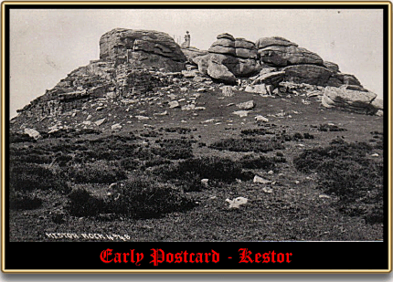
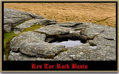
But what started all the excitement? Well, in 1856 a local antiquarian called G. W. Omerod was doing some ‘antiquarianing’ on the tor/rock when he discovered a large rock basin on the summit. It hole had been filled in with peat and stones in a presumable effort to stop sheep from falling into it. When he cleared the hole out it was found to be the largest rock basin and Dartmoor and according to Worth (1988, pp.31 – 32) when empty it measured 6ft 8in wide, 8ft wide and 30in deep. Rock basins are a product of localised weathering and are formed when weak feldspar crystals are split by the frost along their cleavages. This loosens small fragments which are later blown away by the wind thus leaving a small hollow. The process continues and gradually the hollow expands outwards and downwards. Water fills the hollow and then freezes, upon thawing more fragments are eroded which once again are blown away by the wind. Over time the hollow widens and deepens and eventually a rock basin is formed. Shortly after the discovery and clearance of the rock basin Omerod arranged for a fence to be erected around it to stop and sheep from falling into it. The illustration below is of an old postcard in which the fence can be seen just to the left of the lady.
It was about this time that, along with the other rock basins of the moor, they became attributable to the work of the druids. It was supposed that they had carved them out to act as a receptacle for sacred water and for catching the blood of human sacrifices. No doubt deeply influenced by her husband, Mrs Bray (1844, p.218) notes the following:
“It will not, I hope, be deemed a useless digression to mention what is supposed to have been the source of these rock basins. Borlase, in his Antiquities of Cornwall informs us, that they were designed to contain rain or snow water, which is allowed to be the purest. This the Druids probably used as holy-water for lustrations. They preferred the highest places for these receptacles, as the rain water is purer the farther it is removed from the ground. Its being nearer the heavens, also, may have contributed not a little to the sanctity in which it was held.”
Stories such as these would be a modern tour operators dream for they brought the visitors flooding to Kes Tor to see the Druidical remains. Even then this caused a litter problem for as Worth (p.31) complains:
“The modern tripper found it a convenient repository for his broken bottles, and, lest these should not fill the basin sufficiently quickly, he added stones and other rubbish. In 1930 I had it cleared once more.“
Sometime in the 1950’s the railings were removed as it was thought that they presented more of a hazard to the sheep than the risk of falling into the basin did. Careful examination around the edge of the basin will show the holes which were drilled to take the fence uprights. The last time I visited Kes Tor was with a party of my Young Archaeologists, it was a typical Dartmoor day with both wind and rain blowing horizontal. As with any young children they love tales of blood and gore which made the druid’s basin an object of interest despite the atrocious weather. Having explained the theory of the basin one little girl asked, “but where’s the plughole?” When asked why they would need a plughole she replied, “to let the dirty water and bubbles away of course!” Which when one considers the early theory about using pure holy water in each ceremony it does beg the question – “how did they clean it out after each ritual.” Pity the little girl couldn’t have asked the intelligentsia of the 1800’s that question, it might have knocked their theory right on the head.

Bray, E. A. 1844 Legends, Superstitions and Sketches of Devonshire , A. K. Newman & Co., London.
Page, J. Ll. W. 1895. An Exploration of Dartmoor. London: Seeley & Co.
Worth, R. N. 1988 Worth’s Dartmoor, David & Charles, Newton Abbot.