 Legendary Dartmoor The many aspects past and present of Dartmoor

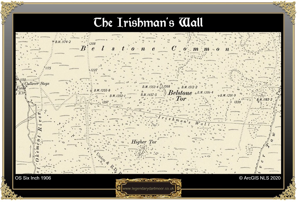
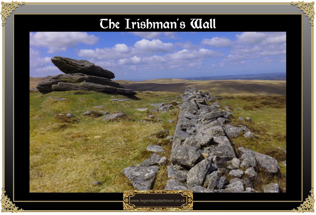
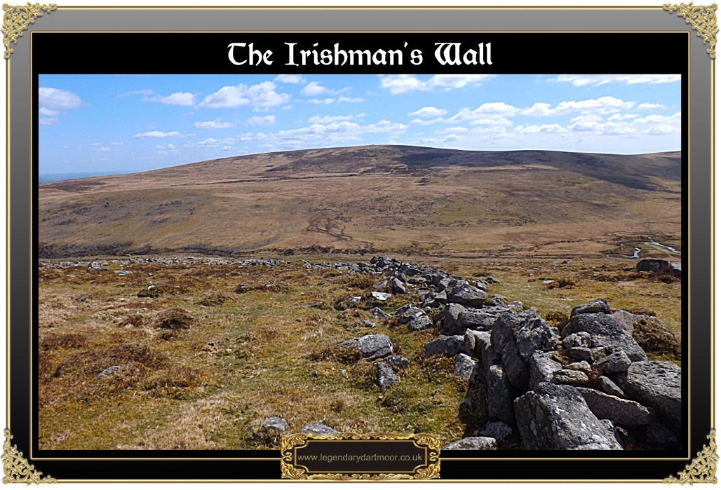
The Chinese built the ‘Great Wall’, the Romans built Hadrian’s Wall and on Dartmoor the Irish built the Irishman’s Wall and like all other great walls this fact is acknowledged by the Ordnance Survey map-makers. So who, where, when and why? Today the remnants of the wall run in a south-easterly line from Cullever Steps to the eastern slopes of Belstone Tor. Today remnants of this old wall run for about 0.815 miles and in effect divides the Belstone Ridge in two. Tradition has it that originally the wall also ran up to near the head of the Blackaven Brook and then over to the Taw Valley as can be seen on the map opposite. If this was the case then effectively the enclosure would have encompassed about 5 square kilometres – a lot of land. As with any landscape feature that runs for a distance the best view of it is from above and thanks to Google Earth the aerial photograph below clearly shows the extent of the wall:
Hemery, p.842, suggests that the Irishman’s Wall had in parts utilised the remains of a Bronze Age reave which yet again is a good example of the Dartmoor despoilers. But why was it built? There appears to be two main theories on this, firstly it has been suggested that the wall follows the old boundary line of the Forest of Dartmoor as was set down in the perambulation of 1786, – James, p.49, but this has been disputed by Brewer, p.41, who considers the Forest boundary ran further to the south.
The other and more plausible reason for the wall was that it was built as part of a newtake which would have effectively enclosed the common of Belstone. Hemery, p.843, says that he connected, “the venture – the piratical initiative, that is – with the busy ‘improver’ Matthew Crawford …“. At this point we also come to the origin of the wall’s name which comes from an account told to William Crossing, 1996, pp.39-40,: “According to an account which I gathered in the locality many years ago, those employed in the building of it (the wall), who were all from the sister isle (Ireland), astonished the people of the moor by their utter contempt for boots and stockings. But they in their turn were probably astonished when one day they found a great part of their work destroyed. The men of Belstone and Okehampton had no notion of having their commons enclosed so they threw the wall down. What became of the Irishmen my informant did not know, but he expressed the opinion that their own country was a much more suitable place for them than Dartmoor. “What could um expect to do ‘pon the moor,” he said, “wi’ nort to their vait (feet).
To add further credence to this story Crossing (1990, p.215) relates how at one time their was a local tale about the ruins of a small house on the eastern flank of Belstone Tor which was where the Irishmen lived whilst building the wall. It does seemingly transpire that the men of Belstone and Okehampton did use a bit of cunning as they waited long enough for the wall to reach near completion before knocking it down and driving away the Irishmen, – Walpole, p.21) As always, Page, p.82, sums the events up in his wonderful turn of phrase: “But they reckoned without their host. The men of Belstone and Okehampton mustered in force, and when about a mile had been completed, applied their shoulders to the loose blocks and, at a given signal, toppled them over – not flat as the walls of Jericho, but, at any rate into such ruin that the Irish trespassers departed sadder and wiser men“.
There is a slightly different version as to who the enclosures were insomuch as St. Ledger Gordon, (1953, p.134) suggests that they were two Irishmen who employed some of their fellow countrymen to build the wall. He also notes how their original plan was to enclose some 2,000 acres of the Forest which clearly they could not have done without the approval of the landowner – The Duchy of Cornwall. This however would not have been a problem for the thinking of the time was that Dartmoor had to become more agriculturally productive by improving the land and the methods by which it was farmed.

So what’s the big deal about a wall built by Irishmen that then got ‘scat’ down by moormen? Just this, for once the common man succeeded in preventing the moneyed man from stealing what was not his at a time when much of Dartmoor was being mercilessly enclosed. In a way the ruined wall should stand as a memorial to the actions of the men of Belstone and Okehampton. The ADS record suggests that the wall was built sometime between 1800 and 1832 but bizarrely they suggest it was, “built by Irish labourers perhaps as a job creation scheme.” The ADS record can be found – HERE. The Dartmoor Archive holds a good photograph of the wall which was taken in 1934 and shows it in a fairly good state of repair – see HERE.
There is an aside to this story, some years ago a group of squatters from South Zeal decided that they were going to enclose various parcels of common land which lay in the Blackaton Valley. This is located about 2½ miles south east of Irishman’s Wall and belongs in the parish of Throwleigh. It seems that there had been a fair stretch of land ‘stolen’ and in respect of this the Duchy of Cornwall sent a gang of men to dismantle the walls. Somehow the squatters got to hear about this and so they immediately went to the scene armed with whatever weapon they could find. A discussion took place along the lines of, “the walls must come down”, and ended up with, “over our dead bodies” and eventually the Duchy men were forced to retire. The scene where this altercation took place henceforth became known as ‘Balaclava’, presumably named after the famous battle of 1854 where the Russians attempted to break the siege of Sevastopol? If this supposition is correct it may lead to the conclusion that this event took place after 1854 as if it was before it could not have been named after the battle? In this case the ‘Russians’ were presented with a face-saving proposition insomuch as the squatters later offered to pay a nominal price for the land to the Duchy, (St. Ledger-Gordon, 1933, pp.27 – 28). The area known as Balaclava was marked out by three boundstones, one is inscribed with ‘DC1’ and ‘SZ1’ (OS grid reference SX 63372 93344), this stone is also known as the ‘Stumpy Post’. The second stone was marked with ‘DC2’ and ‘SZ2’ (OS grid reference SX 63991 92453) whilst the third stone is now missing but was thought to have stood near the enclosures to the south-east, (Brewer, p.48).

Brewer, D. 2002 Dartmoor Boundary Markers, Halsgrove Publishing, Tiverton.
Crossing, W. 1990 Crossing’s Guide to Dartmoor, Peninsula Press, Newton Abbot.
Crossing, W. 1966 Crossing’s Dartmoor Worker, David & Charles, Newton Abbot.
Hemery, E. 1983 High Dartmoor, Hale Publishing, London.
James, D. 1911 Belstone – Devon, Warren & Sons, Winchester.
Page, J. Ll. W. 1895 An Exploration of Dartmoor, Seeley & Co., London.
St. Ledger-Gordon, D. & Harvey, L. 1953 Dartmoor, Collins, London.
St. Ledger-Gordon, D. 1933, Dartmoor in all its Moods, John Murray, London.
Walpole, C. & M. 2002 The Book of Belstone, C & M Walpole, Belstone.
Links not working Tim
Thanks Peter, all should be OK now.
Hi Tim
I read this article with interest as living on Dartmoor and being Irish I’d wondered why the wall had that name. But I’m wondering if the wall wasn’t built a decade or so later. It looks very like the ‘Famine walls’ in Ireland, which are similiar walls that go nowhere on moors & up the sides of mountains and were government schemes as famine relief for the starving people. With over a million forced to emigrate or join the million dying of starvation, every port town in England would have been inundated with pitiful refugees and whatever charity & work house type relief there was would have been overwhelmed. So a scheme like this would have made sense. And the local mentions of the Irish workers being bare foot- surely a sign of these people being the extreme poor and desitute and having nothing left – rather then some usual dressing habit, given winters in Ireland are similiar to Dartmoor.
It might have been a combination of famine relief and also a cheap workforce for enclosing the land for some unscrupulous landowners/businessmen. The migrants acting like ‘scab’ labour, outsiders enraging the locals who seeing their commons being taken and only one step above the poverty line themselves, then took drastic action.
If the Great Famine dates (From 1845-52) work, I think this could make sense and if so, it just adds to the terrible reality of the times where both sets of people, Irish and Dartmoor locals were thrown against each other for basic survival.
Yes, as I was reading the article I came to a similar conclusion as in your comment. As an irish person still living in Ireland looking at one such “famine wall” near to my home that crosses several fields without any logical function and being familiar with Dartmoor, I do feel that the likelihood of famine era construction by destitute refugees is highly likely. Sad that impoverished people’s were pitted against each other by circumstance and poverty.
For info: According to refs at HER MDV103305 there were actually four SZ/DC stones. SZ4/DC4 was originally sited near Nine Stones at SX 654922 but can now be see lying behind South Zeal Mill House.
Update on this; SZ4/DC4 was instated in the Recreation Ground in South Zeal in August 2021 and an information board erected in March 2022 describing the dispute.
for more info: https://www.torsofdartmoor.co.uk/blog/2021/09/01/dartmoor-the-south-zeal-duchy-of-cornwall-stones/