 Legendary Dartmoor The many aspects past and present of Dartmoor

The thought occurred to me that for many months all I have done is to write about Dartmoor and not actually got peat on my boots, so having some holiday I took the opportunity to get out onto the moor. There were a couple of web pages that I had written which needed some photographs to go along with them and so the idea was to have a trundle across Hameldon to rectify the situation.
‘The rambler who takes the trouble to scale this huge rounded ridge will find himself well rewarded, for though he may not, as the moormen say, be able to see the whole of Devon from it, it is certain that he will be able to look over a good deal of the county. Though the western foot of Hameldon is some mile and a half outside the forest, the greater part of the ancient hunting-ground is nevertheless visible, as well as much of the belt of common land encircling it. In fact, there are few prominent heights in the moorland region that cannot be seen from this hill…‘, (William Crossing, 1990, p.240).
Not only are the views wide ranging but the route across the huge ridge is a walk back in time as its length is literally studded with prehistoric cairns leaving one in no doubt that ancient feet once trod there. Over the centuries the hill has been subject to various spellings of its name; Hamel Down (1566), Hammeldon (1652), and more recently Hameldon. I would suggest that the meaning of the name comes from two descriptive elements; hamel which is a Saxon word meaning ‘rugged’, Clark Hall, 2004, p.168) and another Saxon word – dun, which means ‘hill’, (Clark Hall, p.90). When combined they present us with the name of Hameldun or ‘rugged hill’ which then mutated to the various spellings already noted.
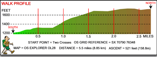
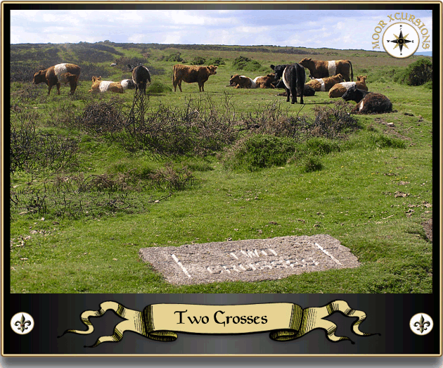
When getting up onto Hameldon you have two options, either park at Grimspound and make a short but steep climb up onto the ridge or start from Two Crosses and have a longer but less arduous climb. A mixture of numerous recent corporate events, cheap Romanian cigarettes and the resulting tight walking trousers meant I opted for the second option.
In order to selfishly have the hill to myself I, along with ‘Zebbers‘, set off from Two Crosses at 5.30am on what was promising to be a glorious Dartmoor day. After a short distance the village of Widecombe came into view, still lightly shrouded in mist the small village below began to shows signs of slowly awakening. The same could not be said of the skylarks who were busily warbling away up in the dawning morning sky. The first part of the trundle was to Kingshead Corner and then on up the slope of Langworthy Hill, where the first of many ‘glider poles’ can be found. These were erected during World War II to prevent Nazi gliders from landing, today they are mere matchsticks compared to their younger day. They do however serve as a reminder of the real fear of invasion that once burned in the hearts of the moorfolk as well as making perches for the birdlife of today. There are still remnants of rusty barbed wire on some of them which would suggest that originally it was strung between them although I can’t see how they would stop a glider landing at full tilt. One of the things I wanted to photograph was the boundstone known variously as Aaron’s Knock or Herring’s knock which stands to the west of Kingshead Tor. Now I am not running the little shit down but Zeb does like to play with sheep, not in the sense of biting chucks out of them, he just likes to play. Therefore he is never let off the lead, this coupled with a whole flock of lambs dotted around the boundstone meant I had to hold him back on the lead and try to take a half decent photo of the stone at the same time. Difficult to say the least which is why his yelps of pain could be heard echoing around the hillside. Before anyone phones the RSPCA there is one thing to remember about Zeb, he’s a big baby, you only have to tap him and he goes off on one and on this occasion a tap was all he had but true to form he went off on one.
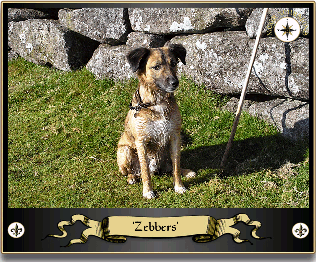
Zebbers |

Widecombe Awakes |
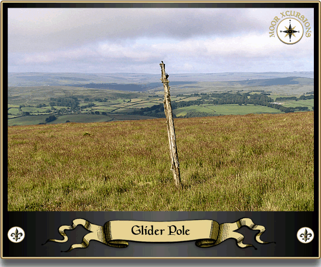
WWII Glider Pole |
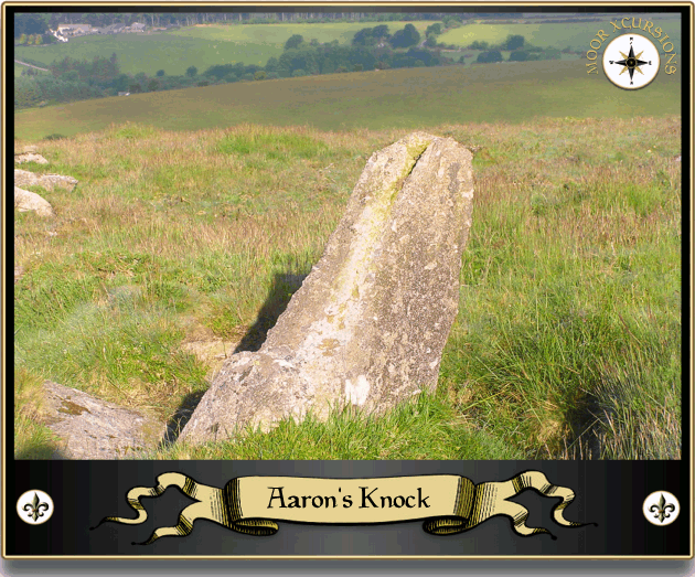
Aaron’s Knock |
The tor itself is what one could only describe as pathetic, no craggy outcrops, no lofty stacks on which eagles nest, just simply a scatter of boulders and a couple of large flat slabs of granite. However they make for a nice resting place where one can get one’s breath back whilst savouring the taste of a Marlboro cigarette. The peace of the morn was glorious, not a soul in sight and the only sounds were that of nature rejoicing in the warming sun. All around were the bleats and baahs of the moorland sheep, overhead two ravens flapped and cronked their way across towards Blackaton. Somewhere below in the enclosures a cuckoo was busily making its presence known whilst over in The Beech Hedge a green woodpecker was squawking in harmony. This landscape feature was planted in the 1800s by the then landowner, Mr Frith and is indeed called THE Beech Hedge, Hemery poetically describes the trees as, ‘straddling the now crumbling hedge, their roots contain it as a buzzard’s talons do a rabbit, (Hemery, 1983, p.635). It is strange how the hedge falls some 600 yards short of the hilltop and is substituted by some hefty stone walling for the rest of its length.
From Kingshead Tor ’tis but a short hike to the top of the ridge which climbs a steady 170 feet. This dishevelled pile of rocks has been over the centuries put to many uses, originally it would have been used as a prehistoric burial cairn dating back to the Bronze Age and as can be seen from its appearance time and man have not let it grow old with gracefully. Hameldon Beacon is recorded as being one of the many sites where beacon fires were lit in times of emergency. This beacon was linked in the chain to Buckland Beacon to the SSE and Meldon hill to the NNW and between them the signal would have been carried about 8½ miles. In a document of the 1500s this spot was recorded as a point on the Natsworthy Manor bounds and was called Fyerbicken which clearly means ‘fire beacon’, (Hemery, 1983, p.629). In 1566 the point was recorded as ‘Fire Beacon’ which in 1659 was once again changed to ‘Fire Barrow’, (Brewer, 2002, p.85). As is obvious today this conspicuous vantage point was used in later years to mark the boundary of the Duke of Somerset lands which comprised of Natsworthy Manor. It is interesting to note that whoever cut the boundstone either had different ideas as to the place name or didn’t do too well at school, as can be seen from the photo below he spelt it wrong – Hamilton. The beacon is also a point on the boundary line of Widecombe Town Manor and is next in line from Aaron’s Knock.
Once upon the ridge it is plain to see where the route lies as the well eroded track clearly shows centuries if not millennia of human footfall. It is from this point that one can begin to see what Crossing meant when he wrote that most of Devon was visible from Hameldon, on a fine day the views simply take one’s eye rolling on and on into the far off horizon. It is also possible to see the distinct types of varied vegetation that grows on the ridge. J. Ll. W. Page wrote in 1895 that descending from Hameldon to Widecombe his route went: ‘from heather to fern, from fern to gorse‘, (Page, 1895, p.212).
A short wander along the line of the wall brought us to another burrow or cairn which again was used in later years as a boundary marker. Sitting like a single Rice Crispy in a cereal bowl the marker stone is engraved as being ‘Two Burrows’ thus once again indicating the lands of the Duke of Somerset. The name Two Burrows also denotes that the stone is situated in another prehistoric burial cairn as ‘burrow’ is another term used on the moor for a cairn. In fact as the place name suggests there are two cairns or burrows lying a few feet apart both of which were ‘investigated’ in 1872. The antiquarian Spence Bate dug into the northerly of the two cairns where he discovered what has since become known as ‘The Hameldon Dagger‘. This artefact consisted of an amber pommel studded with tiny gold pins along with the remains of its bronze blade. In Dartmoor terms this find could be described as being akin to discovering Tutankhamen’s Tomb. This artefact was later taken to Plymouth museum for safekeeping but tragically the building was destroyed in one of Hitler’s bombing raids on Plymouth along with the dagger. Such burial goods can only indicate that whoever was buried here was a person from the socially elite classes, a tribal leader or shaman maybe.
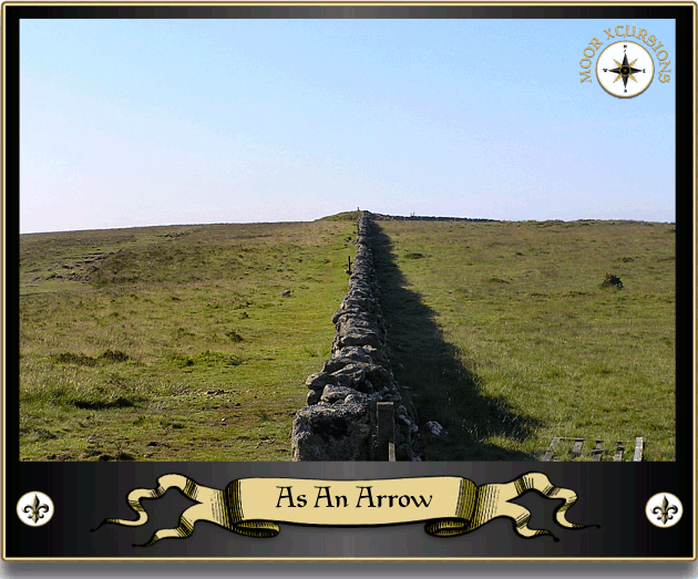
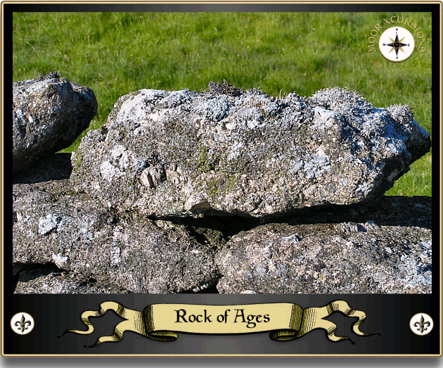
Look at any map of Dartmoor and you will see miles upon miles of stone walls that enclose the various newtakes and it can only be said that the craft of the stone waller displays a distinct variation of skills. As can be seen from the photograph below, whoever built this wall new his trade, I don’t think even with today’s technology this wall could have been built any straighter. Sad as it is, there is something fascinating about old walls, not only is it hard to imagine the toil that went into moving tons of granite and then constructing a solid wall but for them to still be standing centuries later is amazing. Today they are home to a whole variety of mosses, lichens, insects, reptiles and mammals, each lump of granite is a tiny ecosystem which makes for superb photographs. The only drawback with these enclosure walls is that in many cases the granite has been recycled from earlier monuments and structures. Heaven knows how many hut circles, cairns, stone circles etc have been destroyed because someone found it easier to despoil these features than to quarry new stone. Obviously today it would not be allowed to happen, in fact just the opposite occurs with the ridiculous practice of walkers building new cairns as some kind of ritual to leave part of them and their visit behind. I can’t remember whether it was at Hameldon Beacon or at Two Burrows where such an example existed but either way there is a small cairn gradually growing like an ugly wart on the unblemished landscape. For Christ’s sake the original cairns were built to mark a burial or a territory, these modern piles of rocks symbolise nothing. Imagine in 4,000 years time an archaeologist excavating one such cairn and then finding diddly squat, what was its purpose he ponders? Try telling him it was a 21st century ritual whereby travellers added a rock to an ever growing pile to signify that they had passed by, never mind the fact that nobody ever knew who left them. If someone wants to ‘celebrate’ their visit then why not take a fricking photograph instead of leaving a pointless and anonymous lump of rock? I think Zeb summed the whole concept up when he cocked his leg and peed over it in distain, maybe I could train him to have a dump on such things.
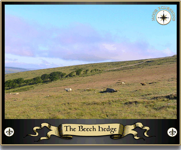
The Beech Hedge |
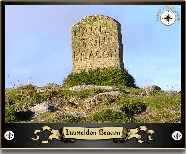
Hameldon Beacon |
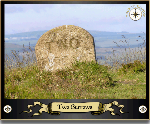
Two Burrows |
The Wall |
Ok, rant over, and another thing, why do people insist on building these bloody piles of rocks actually on an obvious pathway, probably because they don’t have to walk it at night or in thick fog, that’s why? I tell you I would love to get dumper truck and fill it with the contents of one such cairn and then dump the bloody lot on the patio of the last person to deposit a rock on the pile, yeah! And another thing, take the example I have just mentioned, where did these morons get their votive rock from, there are no such sized stones lying loose on Hameldon. I’ll tell you where they got them from, out of the the pissing original cairn which is a sodding scheduled monument, the bastards.
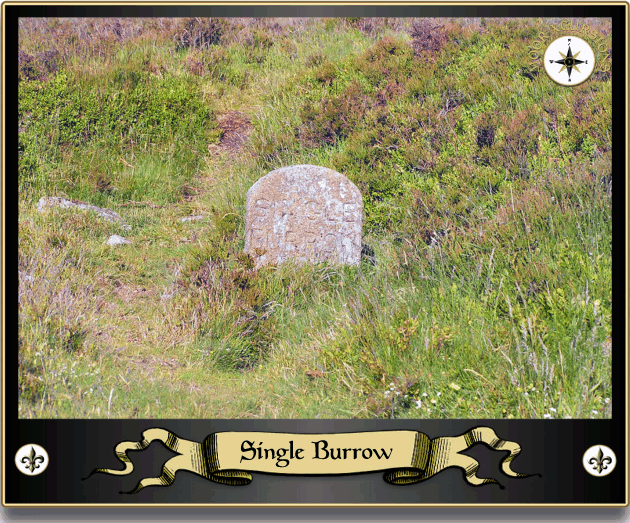
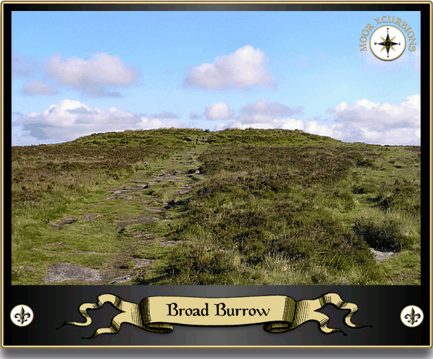
Ok, rant really over, from Two Burrows it was just a short stroll over to the next cairn and boundary point which is called Single Burrow and that is exactly what it was, single burial cairn. This one was ‘investigated’ by Spence Bate and others in 1873, sadly no ‘treasure’ was found just a pile of cremated bone, charcoal and a nearby flint flake, (Butler, 1991, p.148). Once again this cairn also contains a DS boundary stone appropriately cut with the words ‘Single Burrow’. The next port of call was the nearby earthen barrow aptly called Broad Burrow which incidentally is probably the biggest on Dartmoor. It is strange how the trackway ploughs straight through the middle of the mound in a most disrespectful way as can be seen from the photo below. Yet again this landscape feature also serves as a DS boundary point marked with an obligatory boundstone engraved with the word, ‘Broad Burrow’.
Rock of Ages |
Single Burrow |
Broad Burrow |

Broad Burrow |
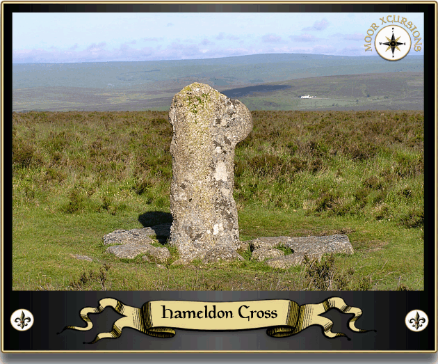
Having visited several sites of pagan ritual it was now time to leap forward into the Christian era and pay a call on a very battered but nonetheless holy symbol of that faith. This being Hameldon Cross which stands slightly off the modern track and stands like a lost soul in a sea of heather. Thought to date from the medieval period this ancient cross has also been utilised as a DS boundary point although it is suggested that it does not stand in its original location. Again the stone cutter had been at work incising the letters H,C,D,S, ( Hameldon Cross, Duke of Somerset) and the date 1854 upon the eastern face.
There are some splendid views to be had from the cross with the brilliant white building that is the Warren House Inn standing proudly out amongst the greens and browns of the far off moorland – mmm Guinness, sadly way too early, later hopefully.
Having said farewell to the cross Zeb and I made for the last port of call on this trundle – Hameldon Trig. This redundant Ordnance Survey triangulation station stands beside a much older redundant relic in the guise of another burial cairn or to be more factual the site of a burial cairn with a modern reconstructed cairn – don’t get on that subject again.
If you are into visiting trigs, and a lot of people are, then this one is numbered OS BSM 3459 and not only will you be able to ‘tick the box’ you will also be rewarded with some splendid views across north east Devon. Both trig and cairn sit upon the heather clad rocks of Hameldon Tor otherwise known as Grim’s Tor. Why Grim’s Tor? Because nestled in the valley below is Grimspound through which Grim’s Lake runs down from Grim’s Lake Mire. Who was/is Grim? Well, depending on who you believe he was/is either Odin or The Devil. The first theory of Odin stems from the now outdated idea that the prehistoric settlement of Grimspound was first settled by the Vikings and that Grimr is the Norse name for Odin. The second notion comes from the Place Name Society and is the idea that Grim is an Anglo Saxon word that means ‘The Devil’, (Gover et al.1992, p. 482). However, if one consults Clark Hall’s venerable tome, he suggests that the Saxon word grimm means fierce or savage, (p.160) so could the place name refer to the ‘settlement of the savage tribe’? Either way there are three ways to get a good view of the prehistoric pound; from the air, from Hookney Tor on the opposite side of the valley or from Hameldon Tor. Do you know, talking about Grimspound, someone recently sent me a photograph of a rusted pistol that they found buried at Grimspound whilst they were out metal detecting and asked what they should do with it. This was a problem, firstly why had a pistol been buried at Grimspound, had it been used in some shooting or simply someone disposing of a dangerous weapon? Secondly it is illegal to go metal detecting on a scheduled monument so the person could hardly go to the Police and say how they found it and I have no idea how the story ended.
Hameldon Cross |

Hameldon Trig |

Grimspound |
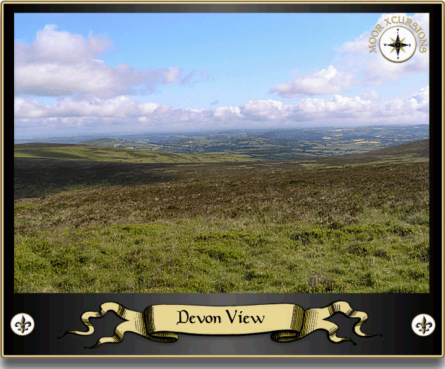
Devon View |
Having reached the furthest point of the trundle it seemed appropriate to halt a while and enjoy the early morning along with some breakfast and a drink before returning back to the car. Whilst sat on the edge of the ridge with the honey bees buzzing amongst the heather the thought crossed my mind as to how easily the worries of life temporarily get erased when on Dartmoor. There is simply too much to see, hear and smell to be bothered with what ever tribulations were left at home, even the dog appeared to be indulging himself as he silently watched and sniffed.
Having achieved all that was necessary we packed up the rucksack and headed back along the ridge, following in the footsteps of ancient man. At the Beacon I spotted a welcoming site across the valley, for there defiantly stood ‘The Giant’s Chair‘ in a far off field. I say defiantly because this sculpture has been the subject of a planning issue with the Dartmoor National Park Authority. The landowner erected a huge wooden chair at the head of the valley which looks down towards Widecombe, its whole purpose was provide people with the opportunity to appreciate the special qualities of the local landscape and to engender a sense of joy and laughter for anyone seeing it. Harmless enough one would have thought, but no, the muppets from the DNPA decided that it attracted too many visitors which in themselves created a traffic problem along the narrow lanes that afforded no parking opportunities. Consequently, they in their finite wisdom decreed that planning permission be denied and the sculpture had to be removed.
Nearby is also a reminder that Hameldon is not just a ritual landscape but at one time was a place where man went in search of the one-time precious lodes of tin. This particular tinner’s gert is commonly known as Tin Pits and although overgrown with heather is still visible as a deep gash in the landscape and can be seen from 9,963ft above (Google Earth – 50º 33′ 27.39″ N, 3º 49′ 21.23″ W). Ironic to think that at one time it was possible, by Royal decree, to go in search of tin anywhere one pleased, even without the landowners approval and today a landowner cannot erect a harmless wooden sculpture?
Not far from the tinner’s gully is what appears to be a kist, Butler (1991, p.149) mentions there being one but gives no exact co-ordinates so whether that was the one I know not. There are certainly three visible slabs lining the earthen chest but the large slab on top does not look like a capping stone, it’s far too deep, it can be found at SX 71009 78345 (GPS).
Now I am no expert on mushrooms but I have a feeling that the clump I came across is what is scientifically known as Psilocybe semilanceata otherwise known as Liberty Caps or as the ‘woo brigade call’ them – magic mushrooms?
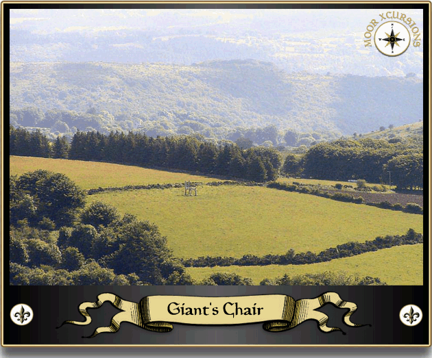
Giant’s Chair |
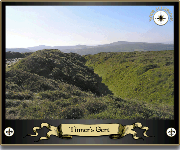
Tinner’s Gert |
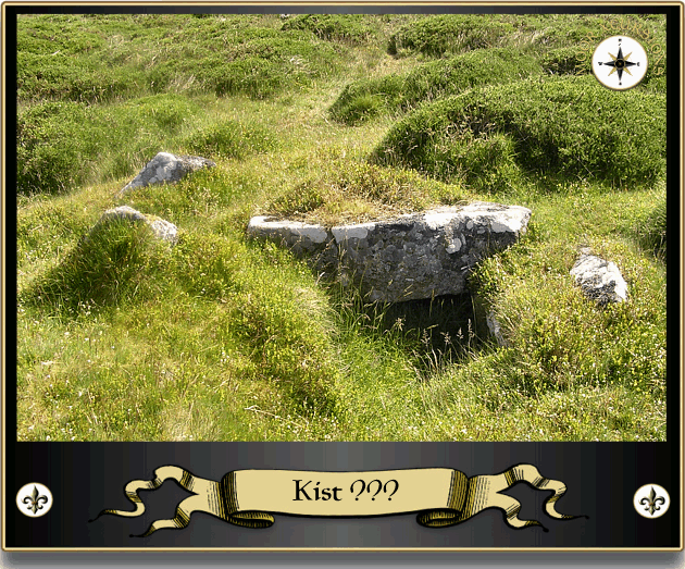
Kist ??? |
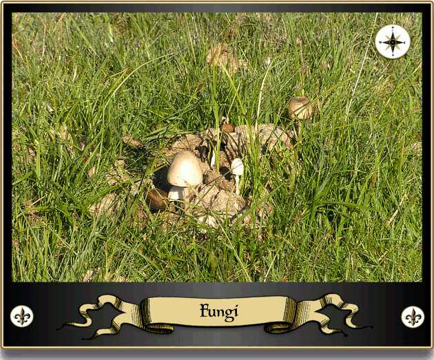
Fungi |
On descending the hill I spotted at the bottom a large herd of cattle all stood or sat around a nursery of calves, ahh how sweet. Problem was that not only does Zeb like to make friends with sheep he also is very amiable towards cattle especially cute calves. Sadly the mothers don’t realise he’s only trying to meet new mates and tend to charge at him which is fine except he is firmly attached to the end of my arms which means they also stampede towards me. So I deemed it prudent to make a wide detour and picked up the old Church Way track which eventually came back out at the Kingshead enclosures. Here, happily munching away at the dewy grass was a fine example of a Dartmoor pony, working on the theory that it’s never good to miss a photo opportunity I frantically began snapping away. What I didn’t see was another, very, very friendly, fine example of a Dartmoor pony coming up behind me. I had just framed the shot when my right arm was suddenly whipped back as Zeb darted away. I then turned to see what was amiss and was greeted with the sight of the pony stood about 6 feet from the dog and both creatures staring intently at each other. It was time to move on and so with dog obstinately refusing to move I literally dragged him along on his arse until he decided to obediently walk. Problem was that obviously the pony had taken a shine to Zeb and decided he was coming too, so with faithful dog at heel and pony following on behind we headed for Kingshead Corner. It is here that the old Church Way leaves the open moor to majestically descend to its final destination – The Cathedral of the Moor.

Dartmoor Pony |
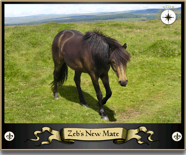
Zeb’s New Mate |
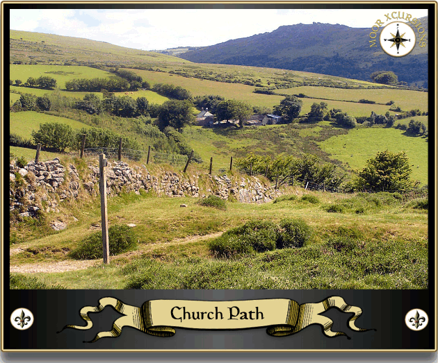
The Church Way |
Two Crosses |
Talking of final destinations ours soon came in sight along with what seemed to be gathering of Belted Galloway cattle congregated around the newish ‘Two Crosses in the Turf‘ stone. I must say the normal colour of Dartmoor Galloways is black as represented in this bunch but also there were some Red Belted Galloways which always remind me of a cream toffee. Having reach the car I quickly bundled the dog into the boot to avoid any unfortunate incidents with both him and the cattle, these Galloways can be some aggressive little sods when they want to be. So all in all a vey enjoyable and relaxing trundle and perfectly timed for solitude.

Brewer, D. 2002. Dartmoor Boundary Markers, Tiverton: Halsgrove Publishing.
Butler, J. 1991. Dartmoor Atlas of Antiquities – Vol I, Exeter: Devon Books.
Clark Hall, J. R. 2004. A Concise Anglo-Saxon Dictionary, Canada: Cambridge University Press.
Crossing, W. 1990. Crossing’s Guide to Dartmoor, Newton Abbot: Peninsula Press.
Gover, J.E.B., Mawer, A., & Stenton, F. M. 1992 The Place-Names of Devon, English Place Name Society, Nottingham.
Hemery, E. 1983. High Dartmoor, London: Hale Publishing.
Page, J. Ll. W. 1895. An Exploration of Dartmoor, London: Seeley & Co.
Hello!
I’m just curious to know the correct pronunciation of Hameldown – is is HAM-uhl-down, or some other way?
Many thanks.
Roy McMillan
Locally it’s Hameldon first recorded in 1566 pronounced Hameldun