 Legendary Dartmoor The many aspects past and present of Dartmoor

Haytor Down, to me in a way it represents something of a what goes around comes around place. Let me explain, several decades ago this was where I went on my very first letterboxing foray in search of what was then the elusive rubber stamps. This was to become a passion verging on what could be called an obsession for many a year. Then I gradually began to take interest in not what was hidden under rocks but what was their history until I stopped letterboxing all together. Then a couple of weeks ago when wandering around Pew Tor with our twelve year old – Holly, things took a turn. Whilst there she found a couple of letterboxes and so it seemed was totally taken with the concept. I promised her that we could go letterboxing again and maybe put out some boxes of our own which she seemed delighted with. Oddly enough back in my ‘boxing’ days I always wanted to introduce a youngster to both Dartmoor and letterboxing and finally this was to be my chance. I think Holly would go anywhere if she thought there was a chance of seeing, preferably playing with, some Dartmoor ponies. So combine this with the lure of the rubber stamp and it should make for a good day out on the moor. Therefore this trip around Haytor Down was to site a couple of letterboxes for her and it will be interesting to see if I still find it as enjoyable. It will certainly enable me to take some photos and as an added interest I decided to follow the line of enigmatically named boundstones that stretch across the southern flank of Black Hill. OK, nothing too adventurous but it will be a start.
Firstly let me explain why this trundle was a crusade. The two letterboxes we were siting belonged to a series called ‘The Elusive Knight’. On Haytor Down is a boundstone called ‘The Templer Stone’ and a nearby track called ‘The Templer Way’. Now as we all know the Templar Knights were Crusader Knights which fits into the theme of ‘The Elusive Knight’. Well it does and it don’t, because clearly the spelling of the Dartmoor Templer is not the same so some modicum of poetic licence has been called upon.
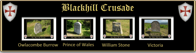
Anyway we arrived on Haytor Down to be greeted with blue sunny skies, ‘Old Crockern‘ must have gotten out of bed the right side for once. Apart from a few early morning dog walkers the down was fairly deserted although the skies seemed to filled with squadrons of trilling skylarks. This led to a quick natural history lesson for Holly as to how the bird always scuttles away from its nest before take-off. The first port of call was to be the Owlacombe Burrow boundstone, one in a line of stones which mark the bounds of Natsworthy Manor and Islington Manor. This boundary line follows what was a perambulation of 1853 of lands owned by the 11th Duke of Somerset (Edward Seymour) who at the time was the lord of Natsworthy Manor and Islington Manor. So this boundary line was to be what we were going to follow.
Now, anybody that ever reads these pages knows that I can never get into the habit of taking with me the OS Grid co-ordinates of anything that needed to be found. This normally means we miss no end of things on the walks – but today I did have the co-ordinates of the boundstones. One slight problem however, by the time we came to look for the first stone I realised that I had left my list back in the car – bummer. However, all was not lost, I did happen to have with me my iPad which did have the OS GB Dartmoor National Park app on it. Now I must confess I had never used GPS to find anything, probably why I never take the grid references? But I was pleasantly surprised, the little blue dot took us straight to the Owlacombe Burrow stone – and they say Dinosaurs are extinct, not in my case.
There is some slight confusion here as the actual Owlacombe Burrow is not the name of the boundstone but more than likely the nearby outcrop. This it is thought to have been a boundary point on the old Anglo Saxon Peadington Landscore which marked the limits of an early Saxon estate and was called Ruwa beorgh which translates as Rough Barrow. The boundstone of 1853 simply adopted the name which some could take as actually being Owlacombe Burrow.
The next stone in the line was as far as the original stones go an interloper and one which could cause confusion. This is the Prince of Wales Stone and is such inscribed on one face along with ‘DNPA 2001 – 50 YEARS’ on the other. This stone was erected in 2001 to mark 50 years of rule by the Dartmoor National Park Authority. Why on earth did someone not realise there was and had been since 1853 another Prince of Wales stone just over 1 kilometre away? Considering that some of the other boundstones in this sequence were associated with Queen Victoria there were plenty of her other children’s names to use.
From the DNPA stone we moved on the short distance to what now is referred to as the WM stone. On the early OS maps this boundary marker is recorded as ‘Old William’. One side of the stone is inscribed with the letters WM and on the other the date of 1853 and an Ordnance Survey bench mark. Again it is just possible that the original boundary point was one that belonged to the old Saxon estate recorded in the Peadington Landscore as the Writelan Stan. The other mystery is that as it was recorded on the OS as ‘Old William’ where has the rest of the inscription gone? Has it been knocked off, especially as when compared to the rest of the boundstones this one appears very rough and ready.
Sadly due to lack of attention we somehow managed to miss the next stone in the sequence which should have been what originally was ‘Old Jack’. I say originally because the present stone is a replacement of a natural stone which was removed in 1853. Again on the early OS map the name of ‘Old Jack’ is recorded as can be seen from the map opposite. Question – why was the stone named ‘Old Jack’ and who was ‘Old Jack’?
Next came the ‘Grandmother of Europe’ – Victoria which compared to the rest of the stones has nearly lost its inscriptions on both faces. This stone was erected in 1853 as previously no stone was in-situ. One question – if as most people suggest this stone is associated with Queen Victoria why was her title not included in the inscription. The other two ‘royal’ stones in the sequence all bear their titles i.e.. Prince Albert and the Prince of Wales?
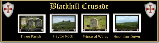
Having paid our respects to Victoria the next point was to be the ‘Three Parish Stone’ which sits at the highest altitude of all the stones on Haytor Down. From here there is a splendid view of the two massive outcrops of Haytor and its quarry. With respects to this stone it’s a case of it does exactly what it says on the tin, the stone marks the meeting place of three parishes, Bovey Tracy, Islington and Manaton. All three are represented with the first letter of their names inscribed on each face. This stone is the only one that is not named on the early OS map as can be seen opposite. By the by, many such stones can be found around the country and my Great Grandfather, who was a bare knuckle fighter, used to fight at such a one. The main reason being that such fights were illegal but in theory as there was no singular jurisdiction there could be no prosecution.
The last stone we were going to pick up was the original ‘Prince of Wales’ not its impostor further back down the line. On the original boundary of 1835 no stone stood here but it was felt that in comparison to the other markers that there was too much of a distance between the Three Parish Stone and the Hole Stone so it was added in 1853. Again there are some good panoramic views across to Houndtor Down and the Haytor area.
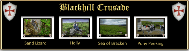
I think at this point there was a pair of young legs that were beginning to tire so it was decided to give the Hole Stone a miss. I think there can be nothing to put youngsters off walking the moor than a force-march especially in the early days. So just to re-ignite some interest we began looking for some suitable places to site the letterboxes. It was whilst doing this then I spotted something slither out from under a nearby rock which made me stop in my tracks. What at first I thought to have been an adder turned out to be a rather iridescent Sand Lizard who obligingly posed whilst its picture was taken.
Having found two suitable sites it was time to get Holly back for the promised ice cream and a spot of ‘Pony Peeking’. I have a feeling that the pace sped up slightly as we trundled back over the Down. It had been many years since I last visited this area and it was alarming to see exactly how widespread the sea of bracken had become. To me it seems absolutely crazy that certain bodies have reduced the numbers of livestock which graze upon the moor. It is the ponies, cattle and sheep that kept the bracken under reasonable control in past times. I think that it is now far to late to reduce the spread of bracken in the short term and so we must learn to live with the problems posed by the dreaded plant – damage to archaeological features and ticks to name but two.
Having got back to the car we then went in search of the ice cream, unfortunately the car lower Haytor car park was full so we drove up to the top one having passed a large herd of ponies in the middle park. There was to be a double disappointment for Holly here. Firstly there was only one pony in residence and secondly there were no sprinkles and chocolate sauce for her 99 ice cream. I had to explain that we were on Dartmoor and this was Molly Mac’s ice cream and not MacDonald’s ice cream.
I was hoping that having petted a pony and devoured an ice cream that would be enough for us to make tracks back up the M5 before the holiday traffic got too bad – wishful thinking. No, we had to call back down to the middle car park where the pony herd was along with a busload of German ‘pony peekers’. It must have been a hot, dry journey up to the moor for them because a huge drinks table had been laid out, groaning with an assortment of beverages. I hate to think what they were feeding the assembled group of ponies, just hope it was not Frankfurters and Bratwurst. Eventually after taking numerous photos, videos and selfies of the ponies the coach roared off in a cloud of diesel fumes. This did give Holly a chance to get close to the ponies without them being scared off by the sight of a large German fraulein, ample bosoms swinging charging at them with her camcorder.
All in all a brilliant day, good weather and excellent company, hopefully this will be the first of many such moor days spent with Holly either letterboxing or just walking upon God’s own country.

Brewer, D. 2002. Dartmoor’s Boundary Markers. Tiverton: Halsgrove Publishing – pp. 94 -95.