 Legendary Dartmoor The many aspects past and present of Dartmoor

It would be remiss not to include ‘The Roof of Devon’ in the folklore and legends section of Dartmoor. Whilst there is no tale or story to tell it surely goes down in Dartmoor’s geographical ‘spectaculars’. The Roof of Devon stands at an altitude of 621 metres which makes it not only Dartmoor’s highest peak it is also the highest peak in England and Wales south of the Brecon Beacons. The place in question is ‘High Willhays’ and today it proudly wears its crown as ‘king of the hills’. However, that has not always been the case as prior to the skills of the Ordnance Survey surveyors the neighbouring outcrop of Yes tor was always been considered to be Dartmoor’s highest point. For such an eminent pile the topographical writers are less than complimentary. Hemery, 1983, pp.883 describes the tor thus: “the rock plies are intrinsically unremarkable when compared with many others in north Dartmoor.”
The earliest mention of the place name is in 1532 when it was Hight Wyll where Gover et al, 1992 p.203, suggest it may be simply a compound of ‘high’ and ‘well’ (spring). William Crossing, 1990, p.201, uses the old Dartmoor name of ‘High Willies’ and in later documents the name High Willows also appears. He suggests that the name derives from gwylfa meaning ‘watching Place’. In light of which it may have been a look-out post for a fire beacon chain. Crossing also mentions that at one time there used to be a small tower on the outcrop which was built by the Ordnance surveyors and the ruins of a small shelter lie nearby. One point of fact that he does mention is that High Willhays is not a tor, it only has an outcrop which leads some people to suggest that it is in fact an extension of the nearby Yes tor.
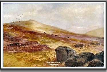
Old postcard of High Willhays.
High Willhays is now officially recognised as a listed ‘Hewitt’ (Hills in England, Wales and Ireland over Two Thousand feet high with a drop of more than 30 metres all round) and also can be classed as a ‘Marilyn’ (which is any hill in Scotland, England, Wales and Ireland with a drop of more than 150 metres on all sides.) I presume the term Marilyn comes as a smaller version of a Munro List (Mountains over 3,000ft high). Confused? I am, but Marilyn, Mary or Great Nelly it is still a big hill, mind you in Wales they would call it a ‘mountain’.
As previously stated, High Willhays is not a tor but another alternative name affords it promotion into one and that is ‘Hampster tor’. This name is listed in Bound’s book ‘The A – Z of Dartmoor tors’ under alternative names and is referenced to Donn’s map of 1765. However, although that map does show a Hampster tor it is located just north-east of Lynx tor (Great Links tor) and below both the river Lyd and the West Okement which is nowhere near High Willhays. So, I would suggest that ‘Old Willies’ is demoted back to a hill. There have even been letterboxes sighted on High Willhays using the name ‘Hampster Tor’.
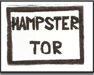
Letterbox Stamp from ‘Hampster Tor’?
One evocative description of sunrise on High Willhays was written in 1930 by C. W. Pilkington Rogers:
“There are the points from which to see the sun rise in summer, if you have the mind, and can summon up the energy, to find out what the world looks like at that hour. One September morning I rose early, and by five o’clock was more than a thousand feet above the border farm where I was staying. During my ascent the sky had slowly gathered light, and as I topped the slope and saw the multiple ridges clear cut against the glow, a long level ray shot over the edge of the moor and pierced the high-flung shadow. Tiny threads of gossamer, heavy with dew and motionless in the pervading stillness, made myriad tracks amongst the heather and sparkled with iridescent light. Slowly the beam moved to the side of an open coombe, swept down the slope and lit the plains beyond, gilding the granite rocks in its passing and touching tawny trees to flame, there, deep fertile valleys to the west were filled with mist so thick, so still, and so contorted, that it looked like a solid glacial field. Beyond a range of hills, fading into indefinite contours and unrecognisable outlines, rose and set a limit to the frozen plain. But to the north there was no bound. Here the illusion complete. It was a land of virgin snow, its horizon lost in the haze of distance. Cold grey skies overshadowed it, and it held all the polar mystery. Eternal and immutable it seemed; yet, even as I watched, the mists began to stir and writhe and finally dissolve. Through them pierced trees and hillocks, islands in the sea that foamed noiselessly about them, and every moment rising higher from a receding tide. The sun was up and the world awake,” – p.140.
Bibliography.
Gover, J. E. B., Mawer, A. & Stenton, F. M. 1992 The Place Names of Devon, English Place-Name Society, Nottingham.
Hemery, E. 1983, High Dartmoor, Hale, London.
Pilkington-Rogers, C. W. 1930 Days on Dartmoor, Methuen & Co, London.
What an interesting article, and what a place to put on my ‘must visit’ list. thank you.