 Legendary Dartmoor The many aspects past and present of Dartmoor

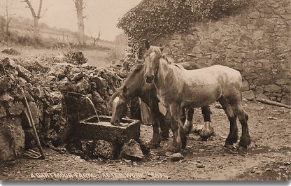
Anybody who visits the Dartmoor National Park today cannot help noticing the strong connection with the equine world. Ponies are all to obvious with their presence and also appear on the park’s log, postcards, souvenirs etc. The first evidence of equines on Dartmoor was found in the 1970’s. This was during an archaeological excavation and was in the form of a hoof print in a 3,500 year old context. The first written record of equines on Dartmoor was found in a document relating to the Bishop of Crediton dated 1012 where there was reference to the “wild horses of Ashburton,” For centuries the horse and/or pony have been the sole means of transport on the moor. They were the equivalent of today’s tractors and quad bikes which provided the muscle power on and around the moorland farms. Most materials were transported either by packhorses or wagons, often in large trains carry loads that varied from wool to tin ore. If you needed to move around the moor it would be on a horse or pony albeit sat in a saddle or driving a cart or wagon.
So it comes as no surprise that equine associated place-names can often be found labeling moorland landscape features, some have been long forgotten whilst others still appear on modern maps. There are even instances where equine names have been donated to modern day rock climbs. Below is a list of those that I have come across in various books, maps etc. Some of the information listed below have been taken from Mike Brown’s ‘Gazetteer of Dartmoor Place names’.
| Place-Name | OS Grid Ref. |
Description |
Comments |
| Donkey’s Cave | SX 77?? 85?? | Location | |
| Donkey’s Corner | SX 6641 8935 | Habitation | |
| Grey Mare | SX 7354 7302 | Boundstone | Marking Buckland bounds |
| Grey Mare’s Groove | SX 7580 7690 | Rock Climb | On Haytor |
| Halter Path, The | SX | Trackway | |
| Horsditch | SX 7412 7623 | Bound | AKA Seven Lord’s Land |
| Horse Brook, The | SX 711 615 | Brook | |
| Horse Ford | SX 6630 7112 | Ford | |
| Horse Hall | SX 601 801 | Location | AKA Horse Hole – Map of R. Burnard |
| Horse Hole | SX 601 801 | Location | AKA Horse Hall |
| Horse Path, The | SX ???? ???? | Trackway | |
| Horsehill | SX 7372 7025 | Habitation | |
| Horselake | SX 7199 8655 | Habitation | |
| Horsepit Cross | SX 7432 8470 | Crossroads | AKA Bovey Cross |
| Horsepit Cross | SX 7432 8470 | Cross | AKA Stumpy Cross & Bovey Cross |
| Horseshoe Bend | SX 6200 9145 | Feature | Ox-bow lake in the Taw River |
| Horseshoe Falls | SX 7106 7042 | Waterfall | |
| Horseshoe Stone, The | SX 752 785 | Boundstone | Marking Manaton bounds |
| Horsey Park | SX 580 813 | Enclosure | |
| Horseyeat | SX 5452 7025 | Habitation | |
| Horsham | SX 7570 8144 | Habitation | |
| Packsaddle Bridge | SX 7891 8024 | Bridge | AKA Hisley Bridge |
| Packhorse Road | SX 5565 7064 | Trackway | |
| Pale Horse | SX 564 763 | Rock Climb | On Little Mis Tor |
| Pony Poole Burrough | SX 7388 7472 | Bound | AKA Pennypowls Burrough, Penny Pole Burrough |
| Whitehorse Hill | SX 61 85 | Hill |
As always with place-names what at first seems obvious soon can become a completely different meaning and some of the names above aptly demonstrate this fact. For instance – ‘Horsditch’, seems fairly simple, at one time there was a ditch that had some connection to a horse? In fact the place-name dates back to 1593, Brown, 2000, p.20. and refers to the location of a prehistoric cairn circle that today is known as ‘Seven Lord’s Land’. There is an old Anglo Saxon word – horh which roughly translates as dirty or uncleanness, Clark Hall, p.190. Could it be that Horsditch refers to a ‘dirty or unclean ditch’ and therefore is nothing to do with horses?
Then we come to the fairly straight forward names such as Horseshoe Bend and Horse Shoe Falls which simply use the shape of a horseshoe to describe a landscape feature. The Horsepath, The Halter Path, Packsaddle Bridge and Packhorse Road all refer to moorland tracks or features along them that were used to transport goods across the moor. Horsham was a place where horses were kept, ham being a homestead or other form of habitation. Horseyeat refers to a ‘horse gate’ or what today is called a moor gate. Horsey Park would have been an enclosure where horses were pastured or kept. Horse Hall or Hole would have derived from a spot, normally a head of a combe which was popular for grazing horses. Horse Hill, Horse Ford, Horselake and Horse Brook again are also places associated with the equine world.
When it comes to boundstones there are three, the Horseshoe Stone marks the bounds of Manaton and Dave Brewer suggests that there is a boulder on the right bank of the Becka Brook that has the shape of a horseshoe on it, pp. 95 – 96. If this is the boundmark in question then it’s name is self-explanatory. Pony Poole Burrough refers to a boundary marker for the commons of Buckland in the Moor and appears in a document of 1683. An earlier record of 1593 calls it Pennypowls Burrough which may suggest a dialect induced mutation from Pennypowls to Pony Poole? Brown, p.16. The actual landscape feature is a prehistoric cairn which on Dartmoor are sometimes referred to as burroughs. As to The Grey Mare stone, which again marks the commons bounds of Buckland in the Moor, one can only guess?
Horsepit Cross is an ancient wayside cross which stands at a crossroads known by the same name (although marked on the OS as Bovey Cross), it was later utilised as an early directional signpost and is said to take its name from a nearby field known as Horsepit, Crossing, p.152. The name occasionally appears as a dialect mutation as Hosspit. In normal circumstances a ‘pit‘ on Dartmoor is associated with tin mining but in this instance there is little evidence of mining nearby? The alternative name of Stumpy Cross derives from its short, ‘stumpy’ nature. Slightly off track but local legend has it that when the nearby church clock at Moretonhampstead strikes twelve times at midnight the cross slowly revolves around three times.
Finally we come to the donkey and the two places once associated with them, Donkey Corner is not marked on the modern OS map but
So there you have it, ‘Horsing Around Dartmoor’ will encompass a whole gamut of landscape features ranging from the prehistoric to the historic and into the modern era all at one time associated with the equine world.
Brewer, D. 2002. Dartmoor Boundary Markers. Tiverton: Halsgrove
Brown, M. 1995. The Gazetteer of Dartmoor Place Names. Liverton: Forest Publishing.
Brown, M. 1996. The Bounds of the Commons of Buckland in the Moor. Plymouth: The Dartmoor Press.
Brown, M. 2000. Gazetteer of Antiente Dertymore. Plymouth: The Dartmoor Press.
Crossing, W. 1987. The Ancient Stone Crosses of Dartmoor. Exeter: Devon Books.
Clark Hall, J. R. 2004. A Concise Anglo Saxon Dictionary. Canada: University of Toronto Press.