 Legendary Dartmoor The many aspects past and present of Dartmoor

The Holy Brook rises on the moorland’s edge to the west of Holne at an altitude of 1,039 feet in a small mire that’s known as Holne Well. The little brook only has a moorland course of about half a mile before it tumbles down another four miles to join the river Dart at Buckfast. But from source to confluence it passes through antiquity, the valley of combes until it pours into the lower monastic lands of Buckfast Abbey. The course of the brook provides habitats for many creatures, some of which have become quite rare species. So maybe what it lacks in length it gains in interest, it certainly has an evocative name which sits nicely with some of the traditions associated with the brook.
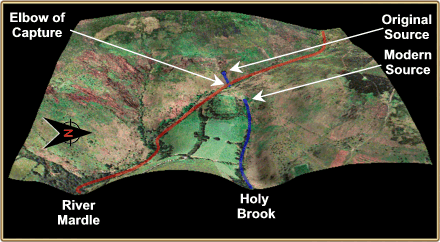
First impressions might suggest that the place-name is due to its course ending up at the old Cistertians monastery at Buckfast. However, Glover et al (1992, p.7) note that the first documentary evidence of the brook dates to the 13th century where it is called Nordbroc. They consider that this name refers to the fact that the brook is just north of the river Mardle which is the next tributary that flows into the river Dart, hence the ‘North Brook’. However, another suggestion is offered by Hamilton (1906, p.12) when he comments: ‘Our Saxon fathers, because it formed, as it does now, the northern limit of St. Mary’s patrimony, chose to call it “Northbroc,” the North Brook; just as the copse on its banks has been called Northwood...’. Ironically, if it was not for a geological intervention the Holy Brook and the river Mardle would be one and the same. The area around the modern-day source of the brook shows typical signs of river capture or ‘stream piracy’. This phenomenon is defined as being:
“The diversion of the headwaters of a river system into the basin of a neighbour with greater erosional activity which is flowing at a lower level; it is known as beheading, river piracy and abstraction. The development of contiguous river systems must lead to one becoming more powerful; gradually it becomes the ‘master stream’, more deeply entrenched and so affording a lower base level for its tributaries. These push back their watersheds with neighbouring streams by headward erosion and ultimately capture them … At the point of diversion there is usually a marked bend known as an elbow of capture (Monkhouse, 1972, pp. 57 – 58).
In 1968, Brunsden (p16) describes the Holy Brook and Mardle as displaying signs of, “imminent capture”, whereas in 1983, Hemery (p.600) considers that it has already happened. He notes that this is a, “classic example on Dartmoor, as well as the easiest to interpret, of the beheading of one river by another” as can be seen here:
So we will now follow the brook on its journey down to meet the river Dart, from ‘moor to monastery’ so to speak. In order to do so the course of the brook will be divided up into sections which correspond with the relevant Ordnance Survey grid squares starting at today’s source.
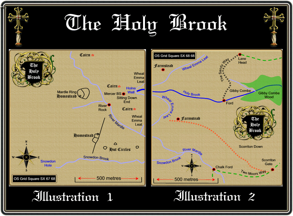
OS Grid Square SX 67 68 – Illustration 1
As already mentioned the birth-place of the Holy Brook is a lot further to the east than it was originally, today the source is in Holne Well. As the waters of the Holy Brook begin their descent they are overlooked by the very pagan remains of Mardle Ring. This Bronze Age homestead in a well preserved example with most of its circuit wall intact. The interior of the wall is subdivided by an inner wall which effectively sections off a third, in which the hut circle is contained. As smaller homestead is located the the south east of Mardle Ring but this is in no way as good a condition. The Mardle Valley has a cluster of seven burial cairns dotted along its eastern side, the largest of which is located at the head of the Holy Brook, Butler (1993, p.1720) measures this at 16.5 x 0.6m.
The area around Holne Well is a meeting place of two parishes, Holne and Buckfastleigh. There are two boundstones in the vicinity to verify this fact, the first being located on the left bank of the Mardle about 200m to the south-east of Holne Well. This is known as River Rock and is simply a natural boulder with the letter ‘H’ inscribed on it. From here the Holne boundary swings over to Holy Brook head where there is another small natural stone marked with an ‘H’. The area where this is located had become known as Sitting Down End, this is due the fact that when the people who stop for lunch when beating the bounds. Near to this, as Brewer, (2002, p.125) notes is a new marker that was ‘unveiled’ at the 1990 beating of the bounds. This boundstone is inscribed with the letter ‘H’ and the initials I. M. which denotes the then Dartmoor National Park Officer and Steward of Holne Moor – Ian Mercer, the stone is often referred to as the ‘Mercer Memorial’. It was erected as a token of thanks by the Commoners for all the many years of hard work he had done for Dartmoor and its communities. Ian Mercer was actually present at the 1990 beating of the bounds and was unceremoniously ‘bumped’ on the stone. There is another boundstone at Sitting Down End and this time the small marker is inscribed with a ‘B’ for the Parish of Buckfastleigh.
To the south of Holne Well is a small tor which is not marked on the Ordnance Survey map but which is known as Gibby Combe Tor. There are several places in the area which have the ‘Gibby’ element in them; Gibby’s Beam, Gibby’s Combe, Gibby Combe Tor and Gibby Combe Wood, it is uncertain who or what Gibby was. Although the OS map calls the various places ‘Gibby’ many of the older topographical writers consider Gibby’s as being correct. It may be plausible that ‘Gibby’ does not refer to a personal name as there is an old Devonshire term ‘Gibby Lamb’ which describes a castrated lamb. Could the name have come from a sheep grazing area? there can be no doubt that sheep were grazed here and about 3 kilometres away there is Lambs Down.
The other landscape feature which can be seen weaving in and out of this grid square is the dried up leat channel known as the Wheal Emma Leat. The man-made course carried water from the River Swincombe to the River Mardle, a distance of around 10 miles and was built in 1859. The purpose of this was to augment the water flow of the Mardle into Wheal Emma which was located in Brook Wood, just to the north west of Buckfastleigh. Robbins, (1984, p.12) suggests that the copper mine was using more water than the Mardle could supply, hence the need for it to be boosted by means of this leat.
OS Grid Square SX 68 68 – Illustration 2
This is the grid square where the Holy Brook leaves the open moor to make its way through the privately owned combes and enclosures of the ‘in country’. It is also the ‘country of combes’ because within a radius of about 2 kilometres there are no less than 7 named combes; Gibby Combe, Warmmacombe, Michelcombe, Greatcombe, Littlecombe, Higher’ Combe and Combe. There is still a reminder that man has been living on the higher moor for centuries in the shape of the extensive field system. The field system covers a 250m belt which runs along the north side of the valley from the brook’s source to Gibby Combe. Very little of the original Bronze Age settlement remains apart from the remains of a hut circle to the west of the marked farmstead and a small clearance cairn to the east. There are also remnants of a pair of parallel reaves and cross banks which are suggestive of ancient boundaries. The area was re-settled sometime in the 1200 to 1300’s when two new buildings were established. The first being a longhouse measuring 14 x 2.5m which contained the traditional two opposing entrances and a chamber at the higher end. The second structure measures 14 x 3.3m and has cross walls at each end. There are also signs of a small outbuilding and a possible un-roofed pen of some kind, (Butler, p.170, ADS 2007 Record No -NMR_NATINV-44185). The reason for the desertion of the farmstead is unknown but it may have been associated with climate deterioration as happened at Houndtor or the drop in soil fertility. Other possible causes may have been disease or displacement due to sheep rearing, (Gerrard, 1997, p.74).
Roughly 230m due south of the Holy Brook on Scorriton Down are the remains of a post medieval (1540 – 1901) farmstead which comprises of three buildings. The first measures 22 x 4m internally and was probably the farmhouse. The other two measure 19 x 4.5m and 14 x 5.5m, all the buildings were built around a yard. No excavation work has been carried out on the buildings so little else is known about a more precise date other than post medieval, (ADS, Record No. NMR_NATINV-441491).
Once again the Wheal Emma leat loops in and out of the grid square where it eventually joins the River Mardle. As the holy brook progresses it’s intersected by an offshoot of an old trackway known as the Sandy Way where it fords the brook in Gibby Combe. The main track leads up from Michelcombe and enters the moor at Lanehead. The Sandy Way was an old moorland path which ran from Holne and Scorriton over the moor to the lower end of Fox Tor Mire and Whiteworks. There is another pathway that swings through the lower half of this grid square and that is the Two Moors Way. This trail runs over 102 miles from Ivybridge on southern Dartmoor to Lynmouth on the south coast of Exmoor.
During the second world war Scorriton Down which lies just to the south of the Holy Brook was used as a military firing range and several exercises took place on this part of the moor. Amongst some of the regiments to use the down were the 12th Infantry Regiment and the Oxfordshire and Buckinghamshire Light Infantry.
Recently Scorriton Down has undergone an extensive programme of tree planting in order to establish a new wildwood that would link the ancient woods on the Mardle to those of Gibby Combe above the Holy Brook. It was estimated that around 4,500 trees were planted on 2.91 hectares of the down, the project took 26 days to complete and involved over 140 volunteers.
Once being crossed by the ford the Holy Brook runs down through Gibby Combe and through Gibby Combe Wood, flowing below the old prehistoric field systems. It is at the point that the brook enters the wood that it can be deemed as finishing its moorland course. From here onwards its literally a down hill journey through the in-country.
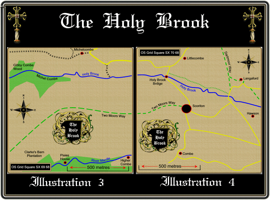
OS Grid Square SX 69 68 – Illustration 3
The Holy Brook now flows down through Gibby Combe Wood and into Michel Combe and then flows just to the south of the small hamlet of Michelcombe itself. This small hamlet is typical of the dispersed settlement that the south west is noted for. During the middle ages much of central, southern and England saw the growth of nucleated settlements whereas this did not occur in western regions. Very simply put a nucleated settlement was where a village grew up around a central focus such as a manor, church or abbey for defence or economic purposes whereas the dispersed settlements remained as small, scattered hamlets or farmsteads. This existence of this small hamlet is first recorded in 1408 and was spelt exactly as it is today. But here is a classic example with place-names insomuch as what you see is not what it means. Logically, one would think that the place-name derives from the personal element Michel and the topographical element Cwm or Combe referring to the steep valley located below the settlement. This would suggest that the name meant ‘the combe of Michel’ or ‘Michel’s Combe’, not a bit of it. Go back to Saxon times and you find the word micel meaning ‘great’ and then the word combe thus arriving at ‘Great Combe’ (Glover et al, p.302, Clark Hall, p2004, p.235). Just to confuse things even more the lands around Michelcombe have been previously known as Holne Bosum which stemmed from Norman times when the Bozum family were granted lands in the area, (Holne Villagers, 1977, p.31). It appears that the Bozum family held the Michelcombe lands until about 1257 when they were given to Buckfast Abbey who held them close until the dissolution of the monasteries when in 1539 they were handed to the Cabell family. This family held the estate until 1886 when it was then sold to the Hon. Richard Dawson, lord of the manor of Holne.
There is a local story telling how whilst cooking dinner at Dodbrooke farm the wife happened to notice a hollow sounding slab lying in the hearth. After managing to prize it open with an iron bar she discovered a hoard of 200 spade guineas, so called because they featured a ‘spade’ shaped shield on them. Nobody knows whether this tale was true but the family did end up buying a woollen factory in Buckfastleigh.
Over the centuries the hamlet of Michelcombe has remained pretty well unchanged and it is interesting to compare the records of the censuses for 1851 and 1861. In 1851 there were 11 household entries which contained 32 adults over the age of 18. Ten years later both figures were exactly the same. If you look at the occupations of the inhabitants very little changes there except that in 1851 there were several people employed in the cloth making industry. The figures below are slightly distorted as in 1851 one of the farmers was also listed as a thatcher but by 1861 he was simply recorded as a thatcher.
| Occupations | 1851 | Occupations | 1861 |
| Farmer | 5 | Farmer | 4 |
| Thatcher | 1 | Thatcher | 2 |
| Farm Labourer | 9 | Farm Labourer | 10 |
| Serge Weaver | 4 | Serge Weaver | 0 |
| Serge Cleaner | 1 | Serge Cleaner | 0 |
| Dress Maker | 3 | Dress Maker | 3 |
| Tin Miner | 1 | Tin Miner | 0 |
| Mine Agent | 1 | Mine Agent | 0 |
| Copper Miner | 0 | Copper Miner | 1 |
| Stay Maker | 0 | Stay Maker | 2 |
| Carter | 0 | Carter | 1 |
| Wool Weaver | 0 | Wool Weaver | 1 |
| Total Workers | 25 | Total Workers | 24 |
| Retired | 2 | Retired | 0 |
| Pauper | 0 | Pauper | 1 |
As can be seen from the above table the majority of the workers were involved in agricultural work of some kind with the rest mainly being concerned with the woollen industry. The National Monuments Record lists that there was a possible blowing house or tin smelting building at Inglett’s Farm at Michelcombe. This theory was arrived at after the discovery of a tin mould stone whilst digging out a cess pit, (ADS, Record Number – NMR_NATINV-441467). Also the same hole yielded what could possibly be a medieval cross shaft, described as being octagonal, granite and measuring 0.25m long and 0.20m in diameter, (ADS, Record Number – NMR_NATINV-441470). Interestingly enough there is still a medieval wayside cross standing about 1 kilometre away at Hawson, could this have been part of a line of crosses leading up from Buckfast to mark the monastic track to Tavistock and Buckland? Just above Michelcombe, the Holy Brook is joined by a small stream which in turn is fed by the Holne Moor leat. The purpose of this arrangement was to augment the waters of the Holy Brook in order it to supply sufficient power to a one time woollen and corn mill.
OS Grid Square SX 70 68 – Illustration 4
The Holy Brook’s journey now passes above the small village of Scorriton which really is the first largish settlement yet encountered. Here there is a pub, The Tradesman’s Arms and a small chapel. Apart from being a typical moorland village there is not a lot to be said about Scorriton, oh, apart from the U.F.O. Yes, in 1965 there was the famous sightings of an unidentified flying object at Scorriton and on the nearby down. In the April of that year a local man, Arthur Bryant was up on Scorriton Down when he saw a large saucer shaped aircraft from which three figures emerged. Bryant had a conversation with one of the aliens and was then shown around the spacecraft. The aliens said they would return a month later, in fact it was two months later when the spacecraft returned over the village of Scorriton. This ‘visit’ resulted in Bryant finding, the next day, pieces of metal, machinery and a glass phial (containing silver sand) where the spaceship had been hovering. If you want to get the full story it can be found in a book called ‘The Scorriton Mystery‘ written by Eileen Buckle.
OS Grid Square SX 71 68 – Illustration 5
The Holy Brook once again leaves ‘civilisation’ and flows on through a contrasting landscape of scattered farms and manorial estates. It is also here that it is possible to follow the brook along public rights of way, albeit for a short distance. The first notable feature that appears enroute is Hawson Cross which stands beside the heavily restored but ancient tree known as the Stumpy Oak. The old wayside cross was mentioned by William Crossing (1987, p105) in the early 1900s when he informs us that for several years the upper portion of a cross was built into a wall. It transpires that one of the arms had been broken off when a waggon wheel ran over it, luckily the broken ‘limb’ was kept and restored. He also says how the cross’s original site was beside a nearby old oak tree, which was known as the Stumpy Oak. In 1952 the old cross was restored to its original position by the Dartmoor Preservation Association when it was given a new shaft to sit upon. Today the cross stands at a height of 2.21 metres, has an arm span of 82 centimetres and a shaft circumference of 1.15 metres, (Sandles, 1997, p.44). The purpose of the cross was to mark the old monastic way which ran from Buckfast to Tavistock and Buckland, as mentioned above this could well link up with the possible shaft found at Michelcombe. Standing over the cross are the much restored remnants of the Stumpy Oak which with the support of some iron rods and cement still defies the ravages of time.
Just south of the Holy Brook lie the old derelict remains of the Wrey Consols mine, also known as the East Brookwood Mine. Hamilton Jenkin (2005, p112) explains how the mine was held under a grant by Sir Bouchier Palk Wrey (hence the name) and was worked from 1857. The sett contained four lodes and by 1860 the main lode had been worked for a length of 60 fathoms. It was claimed to be 5 – 11 feet wide and consisted of quartz, chlorite, gossan and both both black and yellow copper ore. Expenditure on the mine ran to £1,000 and included the driving of a 60 fathom adit and the erection of a 36ft water-wheel. It appears that work ceased here in 1861 when in the November of that year the mine records sales of 1 ton of copper ore which fetched £8. There is then the suggestion (p.115) that work at the mine restarted when it became the East Brookwood mine, again granted to Palk Wrey.
Today there is little left of the mine apart from the wheel-pit, some partially filled shafts and a few adits but back in the 1850s this would have been as bustling copper mine. Today the mine adits are a roost for some lesser horseshoe bats and Hawson Court is a roost for greater horseshoe bats.
It is through this grid square that the Dartmoor Way winds its merry way, this is a 140 kilometre walking/cycle route that circumnavigates its way around the Dartmoor National Park (see website – HERE).
OS Grid Square SX 72 68 – Illustration 6
Nothing is ever easy and that includes the course of the Holy Brook because in this grid square the brook makes a very brief appearance as it flows through the south western corner. As it does the brook skirts past the edge of Hembury Woods and the old Iron Age hillfort that is sometimes known as the Danish Camp.
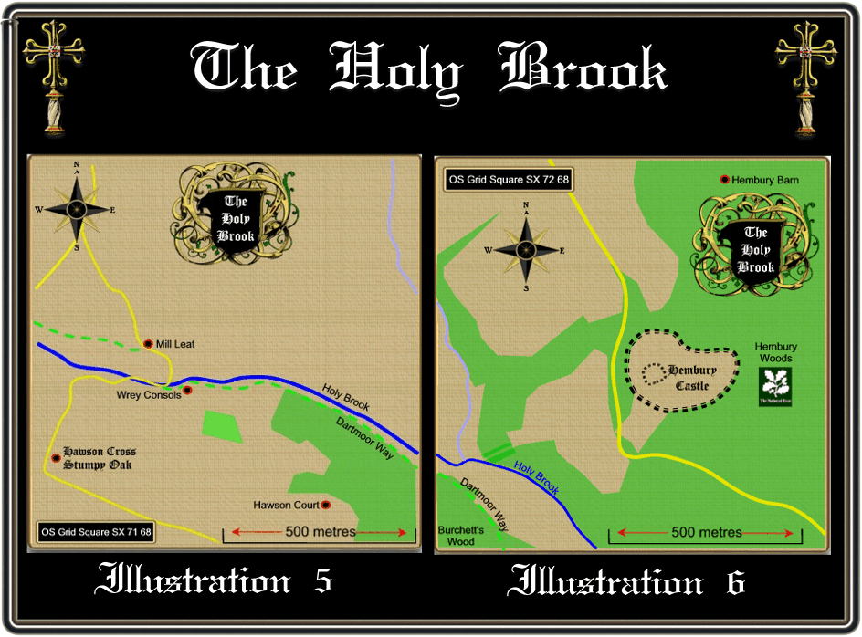
OS Grid Square SX 72 67 – Illustration 7
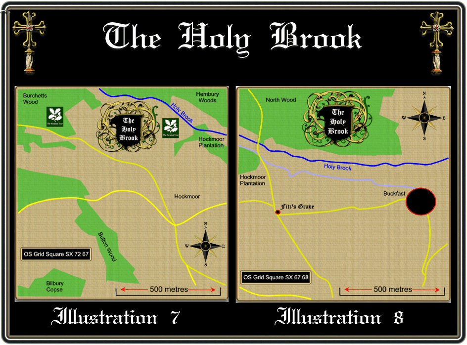
Again the brook fleetingly passes through this grid square as it flows past Burchetts Wood and Hockmoor Plantation, both under the care of the National Trust.
OS Grid Square SX 73 67 – Illustration 8
It is in this grid square that the Holy Brook skirts below North Wood and above Buckfast, about 300 yards down the road which crosses the brook from Buckfast is what is known as Hockmoor Head. Near here is what Crossing, (p.349) calls Fritz’s Grave. Sadly he gives no more information but as it is/was located at a crossroads it could possibly be the grave of a criminal or suicide as it was at these locations they were buried. A comment in the Dartmoor news (1996 p.4) which stated that there was a burial at the crossroads and the person was called Furzes as opposed to Fritz. In the subsequent Dartmoor News (1996 p.4) it was said that locals related how Fritz was a tramp who once lived in a shelter at the crossroads and when he died his wished were to be buried at the site where he lived.
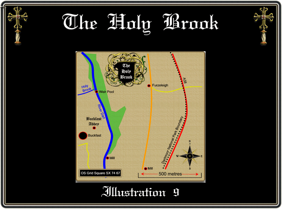
OS Grid Square SX 74 67 – Illustration 9
It is here that the Holy Brook covers its last 100 yard course before joining the River Dart just above the Buckfast Abbey weir. Today the abbey is a popular visitor attraction and is also the place where Buckfast Tonic Wine is made along with the honey from the worldwide famous Buckfast Bees. For further information about Buckfast Abbey visit their website – HERE.
It is now that we come to both the inspiration for this page and a possible explanation for the name of the Holy Brook. Whilst looking for something else I came across the following:
“Holy Brook – it was stated that this was not an old name. But the stream obviously had some antiquity for its numinous reputation since it runs through two fields known as ‘Paternoster’. It has been proved that the water is slightly radioactive, and it is firmly believed to this day that it has curative powers. If you have a strained muscle, bruised yourself, or suffer from rheumatism, etc, you have only to walk right in the brook and the trouble will be ameliorated”, (Brown, 1976, p.187).
Field (1989, pp. 161-2) suggests that enclosures that are called Paternoster are either lands which have a boundary on them where during the Rogationtide ceremonies the Lord’s Prayer would be said or land that was held by service insomuch that one paternoster was said daily for the bequeather.
There is also a record of an old folklore story from 1806 which tells the story of a cottager who once lived somewhere in the valley of the Holy Brook. It tells of how this cottager had a young, beautiful daughter who for a pet kept a pure white snake. Once day the cottager saw his daughter sharing her bowl of gruel with the snake. She would take a spoonful and then give the snake a spoonful and so on, the cottager saw this and became alarmed when he saw the snake move towards the girl. Thinking it was about to ‘sting’ her he rushed across and battered the serpent to death. From that moment onwards the girl slowly pined away and died because of the death of her snake, some say that she was a piskie child.
Today the lower reaches of the Holy Brook sustain a diverse population of wildlife, for ages the brook has been an important spawning place for salmon although their numbers are in decline. Greater horseshoe bats are another animal that frequents the Holy Brook environs and to this end any conservation work of the surrounding woodlands is carried out with their flightlines in mind. English Nature carried out a study of the bat’s in 2003 and suggest that the main roosting sights are in the caves below Buckfastleigh. The study revealed that the bats commuted between 6 and 8 kilometres to forage for food with around 50 square kilometres being covered by the resident population. The Holy Brook turned out to be one of the favourite foraging areas with bats reaching as far up as Hawson Farm which served as a site for night roosting.
Both the British Trust for Conservation and Action for Wildlife have been carrying out various works within the area to ensure the salmon and the bats have optimum habitats to live in.
Thanks to the nice people from Google Earth it is now possible to follow the whole course of the Holy Brook with high resolution aerial photography. The start of the journey can be found at the following location – 50º30’10.72″N 3º51’49.01″W
Bibliography.
Brewer, D. 2002 Dartmoor Boundary Markers, Halsgrove Publishing, Tiverton.
Brown, T. 1976 Beliefs and Customs, Transactions of the Devonshire Association – Vol 108, The Devonshire Association, Exeter.
Brunsden, D. 1968 British Landscapes Through Maps – Dartmoor, The Geographical Association, Sheffield.
Butler, J. 1993 The Dartmoor Atlas of Antiquities – Vol IV, Devon Books, Exeter.
Clark Hall, J. R. 2004 A Concise Anglo Saxon Dictionary, University of Toronto, London.
Crossing, W. 1987 The Ancient Stone Crosses of Dartmoor, Devon Books, Exeter.
Field, J 1989 English Field Names, Sutton Publishing, Gloucester.
Gover, J. E. B., Mawer, A. & Stenton, F. M. 1992 The Place Names of Devon, English Place-Name Society, Nottingham.
Hamilton, A. 1906. History of St. Mary’s Abbey of Buckfast, Unknown.
Hamilton Jenkin, A. K. 2005 Mines of Devon, Landmark Publishing Ltd, Ashbourne.
Hemery, E. 1983 High Dartmoor, Hale Publishing, London.
Holne Villagers, 1977 A History of Holne, Reynard Publications, Tavistock.
Monkhouse, F. J. 1972 A Dictionary of Geography, Edward Arnold Pub., London.
Rendell, P. (Ed.) 1996 The Dartmoor News – No. 32, The Old Dartmoor Company, Okehampton
Rendell, P. (Ed.) 1996 The Dartmoor News – No. 31, The Old Dartmoor Company, Okehampton.
Robbins, J. 1984 Follow the Leat, J. A. C. Robbins Publishing.
Sandles, T. 1997 A Pilgrimage to Dartmoor’s Crosses, Forest Publishing, Liverton.
On-line Sources.
ADS 2007 National Monuments Register, to be found – HERE
OS Grid Square SX7267- additional infomation
In this grid square the Holy Brook used to deliver water to Hamblyn’s Leat (also known as the Holne Moor Leat) via an off-take weir at 728678. The sluice gate is still there, neglected and padlocked shut to prevent interference, but the water level in the brook is way too low (in August 2016 anyway) to have any flow diverted into the leat. The leat is completely silted up and full of vegetation both at this point and for the rest of its length towards Buckfast and the former Higher Buckfast Mill 739674 1000m to the east. When Hemery (see references, page 65) was writing about this leat in 1986, he wrote that “there was a liberal flow entering the leat” although expressing regret that “the regular maintenance once carried out over the entire course by the Hamblyn management leading to the site of the waterwheel is now discontinued”. So this part of the leat needs to be noted as no longer flowing….nothing lasts forever and at least the leat has performed its original purpose for as least 150 years- 4 times as long as its companion Wheal Emma leat. The Holne Moor section of the leat is still flowing freely however to the thirst-quenching happiness of cattle and ponies.
The weir is not marked on the OS 1:25000 map but Hemery clearly includes it on his sketch map of the main (3) leats crossing Holne Moor; it is also clearly marked on the Victorian 6 inch to the mile map of the area. Let’s hope English Heritage protects the former Higher Buckfast Mill waterwheel for a few generations to come.