 Legendary Dartmoor The many aspects past and present of Dartmoor


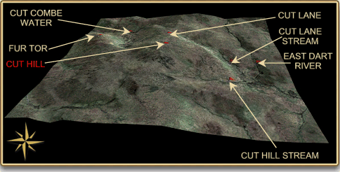
Cut Hill is either a place you love or detest, it is one Dartmoor’s remoter spots and is the fourth highest of Dartmoor’s hills. At first glance it consists of nothing but peat hags, boggy pools, tussocks and other such messy things. To reach it will involve a good walk and if wet, a thorough soaking. The 3D map below shows the remoteness and terrain of Cut Hill.
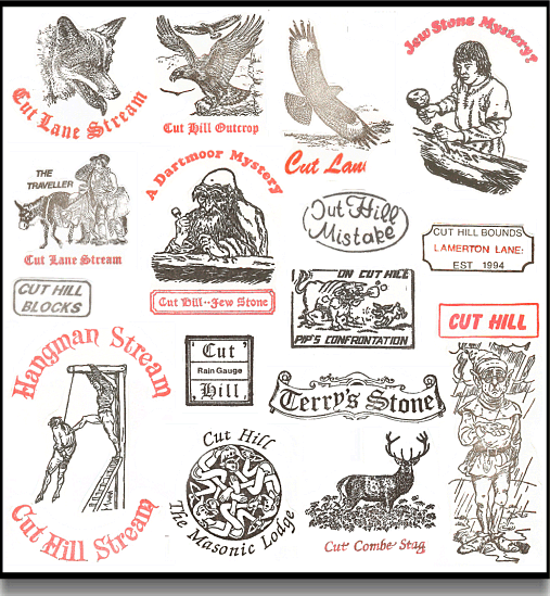
Without doubt it can be described as the Mecca of Letterboxing with literally hundreds of boxes hidden all over it. The Cut Hill aficionados have their own names for various rocks and features which unless you know where they are will literally leave you clueless. Amongst them are; Jude’s Table, Terry’s Stone, The Rain Gauge, The Guide Stone, The Blocks, The Jew Stone, The Pipe, The Outcrop, The Strewn Timbers, The East Crosses, The West Crosses and at one time there was the rotting corpse of a pony that had boxes placed off it. Not long ago certain letterboxers would literally spend all weekend on Cut Hill searching for boxes. The competition as to who had the most Cut Hill stamps was ferocious and some of the clues nearly impossible to get. There was a special badge awarded to anyone who collected over 100 Cut Hill letterbox stamps which at one time was not difficult. At this time, literally anything that happened on the hill would soon have a stamp sited deep in some peat bank. Maps were drawn of the hill showing all the various names of the features, in fact one boxer drew out the bounds of the hill which consisted of numerous markers. Secret inscriptions would be made on rocks and then boxes sited which alluded to them, again if you did not know where they were you had no chance of finding the boxes. Today the Cut Hill craze has somewhat abated but it still very popular with boxers. Below are just a few examples of some Cut Hill letterbox stamps many of which are excellent rubber cuts.
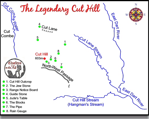
I have not visited the hill that much but there must be over 100 stamps in my collection, personally speaking I used to find Cut Hill one of the most boring places on the moor. However if the letterboxing aspect of the hill is ignored there are some supposed Bronze Age features to be found along with a nice peat pass or two, a mysterious stone and at one time a glaring mistake by the Ordnance Survey. The map below shows some of the more commoner names and places of Cut Hill, many more remain a ‘top secret’. According to Gover et al, 1992, p.193 Cut Hill takes it’s name from the nearby ‘Cut Lane’ as do many of the surrounding geographical features.
Look on any 1:25,000 OS map of Dartmoor (including the latest 2005 issue) and at Grid Reference SX 60850 82521 you will see, clearly labelled, “Cut Hill Stream”. Hemery, 1983, p.477, states: “OS, on their 1:25,000 map have in error given this name to the stream now described; it belongs to the neighbouring tributary, unnamed on the maps which is Cut Hill Stream.” That statement was published in 1983 and 22 years later the mistake has not been corrected as can be seen below:
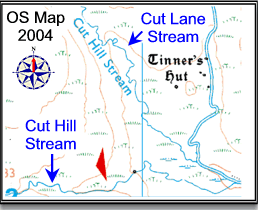
Just to confuse things even more, if one wished to be truly pedantic then the correct ‘Cut Hill Stream’ should in fact be called ‘Hangman’s Stream’ as this is what it was known as by the old moormen.
With regard to the mysterious stone, this is what is known as the ‘Jew Stone’ because on it is inscribed the letters J E W. Nobody seems to know what the inscription stands for but what has been realised is that it is possibly carved onto a fallen stone from a Bronze Age row.
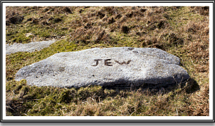
The Jew Stone –
(my thanks to Sam & Rose Mulligan for the photo.)
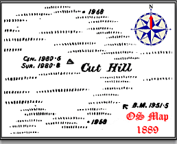
It was rumoured that at one time there was also an old wooden OS trig point on Cut Hill, this was removed long ago and never replaced. It is marked on the old 1889 OS map as can be seen below so there may possibly some credence in this fact.
In 2004, Dr, T, Greeves discovered that there are possible unrecorded prehistoric features on Cut Hill in so much that there is a barrow, cairn and a stone row comprising of 6 fallen stones. The row is aligned roughly NE/SW (52º/232º) and is situated on the top of the hill at grid reference SX 59928275. Five of the stones are visible along a 100m strip of ground where the peat has been eroded, they are spaced uniformly between 19m and 29.5m apart as can be seen from the plan below.
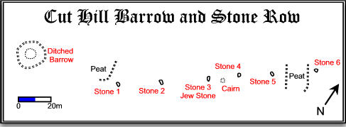
Adapted from T. A. Greeves’ original plan
The Prehistoric Society, July 2004
|
Stone number 1 measures 2.3 x 0.9m |
|
|
Stone number 2 measures 2.4 x 0.8m |
|
|
Stone number 3 measures 1.85 x 0.7m and is the ‘Jew Stone’. |
|
|
Stone number 4 measures 1.9 x 1.2m |
|
|
Stone Number 5 measures 2.6 x 0.7m |
|
|
Stone number 6 measures 2.1 x 1.05m |
It appears that each of the stones had been deliberately selected for the purpose of giving the row the appearance of a thin, 0.20m line of uprights when viewed along the axis of the row but a much wider row when viewed from either side of the axis. The actual length of the row is 123m but there is another possible slab that may also have been part of the line, this would extend the row to 157.5m. The alignment of the row runs to within approximately 22m of the barrow’s centre and stone number one lies 58m WSW away. The barrow is 14m in diameter and approximately 1.5m high and consists of a superficially almost stone-free mound. Past the mound there are suggestions of a 1.5m wide berm or flat space which separates the barrow from the surrounding ditch which is 2m wide and defined by an 2m outer ring bank.
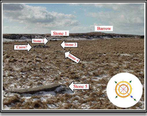
Photo – E. Red, The Modern Antiquarian.
Greeves suggests that of the 80 odd recorded stone rows on Dartmoor this particular feature shows several anomalies in so much as:
|
The altitude of the stone row is approximately 100m higher than any previously recorded row on Dartmoor. |
|
|
The stone slabs are some of the largest used in a Dartmoor stone row with only Staldon and Piles Hill rows showing anything like the size. |
|
|
“Of special interest are the messages potentially contained in the peat associated with the row. It is usually suggested that blanket peat began forming at 600m on Dartmoor in the 4th millennium BC (e.g. Caseldine & Maguire 1981, 8). Could the row be as early as this, or are we to assume that the peat formed later?” This theory is based on the argument used by Greeves that: “the peat has eroded by either natural or human agency, and appears to be on a prehistoric land surface about 1.4m lower than the present top surface of the peat.” |
This idea would mean that the stone row was erected during the Early Neolithic period. Whilst nobody would dismiss the idea of a ‘previously un-recorded’ stone row the dating and context is very questionable:
“Stone rows and stone alignments began to be built from the early second millennium..,” Darvill, 1996, p.94.
” By the end of the Bronze Age deterioration of the soil and pasture forced people from their homes, but the five or six centuries before this had produced not only a pastoral population in the south-west of Dartmoor but also a form of monument that cannot perfectly be matched elsewhere in the British Isles, the well-known stone rows…,” Burl, 1981 p.110.
“Environmental evidence suggests that Dartmoor was used on an increasing scale from the mid third millennium BC, and this is consistent with the dating evidence provided by burials from the area. At first it may have been visited seasonally by communities from the surrounding lowlands and it was not until about 1700BC that the land was sub-divided by the reaves. In between, the archaeological evidence is dominated by specialised forms of monument: burial cairns, cists, stone rows…,” Bradley, 2002, p.74.
“By about 2500BC, after perhaps a thousand years of small-scale hunting and grazing in the uplands, pressure on this land seems to have intensified. At this time (though the dating evidence is very thin, and the chronology depends partly on the comparisons made with the archaeological sequence in other parts of southern England) over seventy stone rows were built…,” Fleming, 1988, p.95.
“Neolithic (c.4500 – 2300BC)… Other types of monuments, some of which may have been built towards the end of this period, are the stone rows…,” Gerrard, 1997, p.33.
“Many megalithic rows and menhirs and the stone circles to which they often attach may well date from the end of the second millennium BC (of Beaker and early Bronze Age date).” Malone, 2001, p.188.
Greeves also postulates that the stones were especially selected for their purpose but to confirm this one needs to know what that purpose was. Because every stone row may have had a differing a purpose which required varying shapes and sizes of stone. With regards to the cairn, Greeves states: “The small cairn shown on the plan may be modern.”
You certainly meet some strange people around Cut Hill like an oriental gentleman wearing jeans and a t-shirt kitted out with a Tesco’s carrier bag in a snowstorm. On another occasion whilst mooching about Cut Lane Stream, which incidentally was about 3 inches deep at the time, I met an fully equipped angler fishing for trout. On several occasions there have been encounters with people asking if they were anywhere near Cranmere Pool because their map shows they should be there, well not bad navigation, only about 2 miles out! In 1984 a grass fire caused by a camping stove caught hold and took out a lot of hill killing many ground nesting birds and melting a multitude of letterbox stamps.
Bibliography.
Many thanks to Sam and Rose Mulligan for their much appreciated help with this page.
Bradley, R. 2002 The Past in Prehistoric Societies, Routledge, London.
Burl, A. 1976 The Stone Circles of the British Isles, Yale Pub., London.
Darvill, T. 1996 Prehistoric Britain, Routledge, London.
Fleming A. 1988 The Dartmoor Reaves, Batsford, London.
Gerrard, S. 1997, Dartmoor, Batsford, London.
Gover, J. E. B., Mawer, A. & Stenton, F.M. 1998 The Place-Names of Devon. The English Place-Name Society, Nottingham.
Greeves, T. A. 2004 Megalithic Stone Row Found on Dartmoor’s Remotest Hill, The Prehistoric Society – on-line source found at
http://www.ucl.ac.uk/prehistoric/past/past47.html
Hemery, E. 1983, High Dartmoor, Hale, London.
Malone, C. 2001 Neolithic Britain and Ireland, Tempus Pub. Stroud.
My 2013 revision of the OS 1:25000 sheet now shows the previously unlabelled Cut Hill Stream as… “Cut Hill Water”.
Keep up the good work!