 Legendary Dartmoor The many aspects past and present of Dartmoor

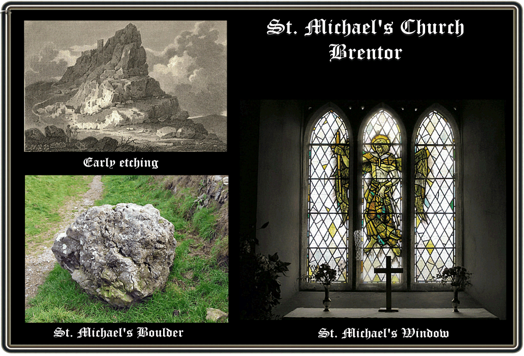
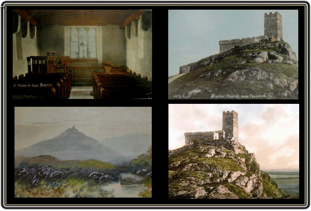
One of the more prominent features of Dartmoor is the tiny church perched on top of rocky outcrop known as Brentor as can be seen from the dramatic early etching below. There are various versions of how the tiny church became to be built clinging precariously to the volcanic outcrop. The first version relates how a wealthy merchant was caught at sea in a violent storm. With gigantic waves crashing over his boat he feared he would never venture on land again and instead be cast down into the very depths of the ocean. The boat was being flung around like a cork in a bathtub and in desperation he vowed to any god or deity that could save him that if he could be safely delivered ashore he would build a church upon the first tract of land he saw. His prayers were answered and upon stepping ashore he saw Brent tor. Being a man of his word he built that promised church on top of the tor.
Another similar version provides a few more characters to tell its tale. We still have the wealthy merchant caught in a mighty storm off the coast of Devon. However this time we also have the Devil. Apparently in a moment of boredom he decided to create a terrible storm and wreck a ship or two for sport. So that very night he conjured up a mighty tempest. The wind blew out the beacon fire on Brent tor thus hindering any nautical navigation. Much to the Devil’s disappointment the ship carrying the wealthy merchant rode the storm but by daybreak was drifting perilously towards the rocks. Satan had decided to fly over the ship to watch its final downfall and see the helpless sailors drown in the massive swelling waves. In desperation the merchant prayed to his patron saint for rescue, in return he vowed to build a church on the first and highest land they saw and that church would be dedicated to his patron saint who happened to be St. Michael de la Rupe. A battle of wills then ensued between St. Michael and the Devil and luckily for the ship and its crew St. Michael won. The ship was delivered safely to port and lo and behold the first high land the merchant saw was Beacon tor otherwise known as Brent tor. Again as this merchant was true to his word and work began on building a church on the tor. The Devil saw what was going on and every night he would go to the top of the tor and kick down any building work that had been thus far built. This went on for many days and eventually the merchant once again appealed to St. Michael for his help. The valiant saint once again came to the merchants aid. The next night when the Devil arrived at the top of the tor he found St. Michael waiting for him. The saint heaved a mighty boulder at the Devil and hit him on his heel. This sent the evil one howling and limping off into the darkness of the night. The next day work began again but this time it was not demolished during the night and slowly the small church was built on top of the tor. It is suggested that this church is the smallest church on Dartmoor due to the fact that the merchant had wasted most of his fortune during the struggle with the Devil and the church was built with what little money he had left. According to this version the church is known to the moorfolk as ‘The Candle’ in memory of the beacon that once stood there.
A third version tells how far back in the distant times there was a settlement at the bottom of the tor. The inhabitants were pagans and worshipped the Devil. Eventually they decided they would build a church and become Christians. The site for this new edifice was to be at the bottom of the tor. Obviously the Prince of Darkness was none too happy to be losing his followers and so he waited until the church was finished and then went into action. The following morning the villagers awoke to find an empty churchless void. Downhearted but not defeated they decided that the following day they would rebuild their little church. The breaking dawn saw them rising from their homes prepared to begin the work of rebuilding the church. As they approached the tor they noticed that the Devil had put the original church back but not at the bottom of the tor as they had planned but he had perched it precariously on the top. After much deliberation they decided to leave it there and that they would endure the steep climb to the top. A messenger was sent to Exeter to ask the Bishop to come and dedicate the church. A few days later he arrived and the church was dedicated to St. Michael. This particular saint was chosen because St. Michael held the hilltops in his care. After the service one very angry Evil One appeared and confronted the assembly threatening various dire acts of retribution. During his wrathful tirade a bright light descended from the sky and the Archangel St. Michael appeared and confronted the Devil. A mighty battle ensued and St. Michael slung the Devil off the tor onto the rocks below. Then picking up a heavy boulder he hurled it down on to the Devil. Mortally wounded the Devil disappeared never to be seen again. However the big boulder that St. Michael threw still sits below the tor (see below) ? This version is dated to the 12th century. Another story attached to the church is that of the floating coffins. Because of the very shallow soil on top of the tor it was difficult to bury the dead in ground so they were kept in the crypt. Many years ago a violent storm hit Dartmoor and the rain was relentless. Once the storm had passed over it was noted that the crypt had become flooded and all the coffins were floating around like boats on a paddling lake.
Now for the serious stuff, the first mention of the church is in the Woburn muniments and according to Finberg, 1969, p.16, it was between 1155 and 1162 when Robert Giffard, the lord of Lamerton and Whitchurch built the church. This he gave along with some surrounding land to Tavistock Abbey as a perpetual gift. The actual charter reads: “My father, Robert Giffard, gave the rock of Brentor to God, St. Mary and the church of Tavistock as a perpetual gift, also thirty acres of his land at Lamerton, and the church of St. Michael which he built on that same rock at his own expense“, Burton & Matthews, 1990, p.7. This gift also resulted in the creation of a new manor which was known as Holeyeat. It is thought by some that Robert Giffard was the wealthy merchant who the legend pertains to?
The first recorded dedication of the church appears in 1155 and was to St. Michael although there was a slight confusion in 1740 when John the Baptist was recorded. It is thought that this mistake arose due to some confusion with parish feats day, Orme, 1996, p.137. It is probably no coincidence that many churches that are dedicated to St. Michael are found on high ground or had lofty steeples. Morris, 1998, p.56 draws attention to an interesting possibility and that is: In Gaul the cult of St. Michael came about by the complete substitution of him for the previously worshipped God, Mercury. Both were active in the heavens and each were said to protect souls. Mercury was thought of as a guardian of flocks and herds and this attribute would explain why so many church dedication to St. Michael are were found in upland, pastoral areas such as Brentor. Many of the sacred sites of Mercury were high places called Mercurii Montes and once St. Michael had replaced him the sites were known as St. Michael’s Mounts. Does this begin to sound familiar in the context of Brentor? Morris also notes that in both Gaul and Britain Mercury was equated with a ‘Celtic’ god called Lugos or Lugus an association which carried on into the Roman period. Now this god is also reflex of the Irish god Lugh or Lug, could it be possible that the early pagan inhabitants of the settlement at Brentor worshipped the god Mercury or some associated ‘Celtic’ deity and then replaced him with St. Michael when Christianity came to the area?
The church was officially dedicated by Bishop Stapledon on the 4th of December 1319. Maybe it would be now prudent to look at the present-day building, in 1952 Pevsner describes the church as follows:
“An exciting sight for miles around. Small 13th century church with west tower on steep cliff of volcanic stone, standing all alone with its west front not 3ft from the precipice. The site must have been of importance long before the church arose, as is proved by the walls of an earthwork around the rock. The church itself is 40 by 14ft with a west tower 32ft high. The tower is embattled and unbuttressed. The church has battlements on a corbel-table. The windows are deeply splayed inside but only slightly outside, i.e. 13th century at the latest… PLATE. wine cup with arabesques, London made, 1596″. pp. 61-2.
There is some slight discrepancy in the measurements of the church as Burton and Matthews, p.12 considers that the dimensions are 37 x 40ft and they also note that this makes it the fourth smallest parish church in England. They also note that the low, ten feet walls are about three feet thick and were built from a volcanic rock known as ‘spilite’ which was taken from the tor. The walls are also dressed with a green slate stone taken from nearby Herdwick. Doorways are situated in both the north and south walls are possibly date to around the 14th century. The largest window is located in the eastern wall and contains a stained glass depiction of St. Michael. Here he can be seen holding the sword of righteousness in his right hand and the scales of justice in his left (see below). The window was designed by James Paterson of Bideford and was placed in-situ in 1971. The window was dedicated by the then vicar Gerald Matthews in memory of Charles Kingsley Burton. In 1964 he bequeathed £100 for the ‘beautifying’ of the chancel and that money went towards the cost of the window. In 1889 the ninth Duke of Bedford donated £728 for the restoration of the church which by then had become very dilapidated. Included in this work was the replacement of the roof with what is said to be an accurate replica of the original 15th century one. During the restoration around forty inhumations were found beneath the floor with 39 skeletons lying north to south and 1 east to west. This in itself seems strange as most Christian burials are orientated east to west as Daniell and Thompson, 1999, p.68, point out when they say: “The commonest alignment is east – west; this can be either Christian or Pagan, but as east – west is the Christian norm, a north – south alignment is often assumed to be a pagan burial“. Parker Pearson, 1999, p.6, further adds; “Christian burial are laid west – east with their heads to the west so that they may arise on the Day of Judgment to face God in the east. Within the pagan religions of post-Roman England and Viking Scandinavia, burials are orientated broadly east – west or north – south, copying the two orientations for longhouse dwellings of those periods“. So, big deal, so what? The point that interests me is that both of the above quotations concur that in general pagan burials were orientated from north to south, so in that light, if 39 burials were found under Brentor church and they were on a north -south alignment would this suggest pagans? Because if it did then why were pagans buried under a Christian church? Could it be they were placed there before the church was built?
After that slight detour we will return to the church’s restoration. The work was finally completed and the church was re-opened for worship by Dr. E. H. Bickerseth, the Bishop of Exeter on the Whit Tuesday of 1890. The tower of the church was either added or reconstructed in the 15th century and today it displays various inside drainage holes which are designed to take the water away that seeps through the porous granite. The other measure against the harsh moorland weather is the provision of movable shutters whose purpose is to block the driving rain from coming through the louvres of the bell chamber. Talking of which, it was noted in a church inventory of 1553 that in the parish of Brentor there were, “ii belles yn the tower their…”. Burton and Matthews, p. 15 enlighten us further to the fact that these bells were cast by a 14th – 15th century founder and inside on one of them was inscribed, “Gallus vocor ego, solus per omme sono”, which translates as; ‘I am called the cock, and I alone sound above all’. Lovely inscription that and I can think of a few mortals of today who should adopt that as a motto! A third bell was added in in the 17th century and this one was inscribed; “TPI Colling W Nichol H Davis Wardens 1668”. In 1909 the whole peal was recast and two more were added for good measure this was carried out by a London company called Mears and Stainbank and the bell frame was made by a W. Aggett of Chagford who also re-hung the bells. The peal was dedicated at a service held on the 20th of August 1909 by the Bishop of Exeter, Archibald Robertson. Additional restoration work was carried out in 1958 when the girders that secured the bells were replaced and again in 1963 when the bells were re-hung on new bearings. These bells have had the distinction of marking numerous events and occasions such as the ending of the 1746 rebellion and many royal birthdays, accessions, and coronations. Traditionally the bells could be heard on Oak Apple Day, Gunpowder Plot Day, and whenever the ‘bishop’ passed by the church. It was suggested in 1866 by James Hine that the church was a beacon church which meant that a fire would be lit to warn of invasion. Indeed on the 21st of June 1887 Brentor was part of the beacon chain used to commemorate Queen Victoria’s accession jubilee when a Malvern Rocket was discharged at 10.00pm.
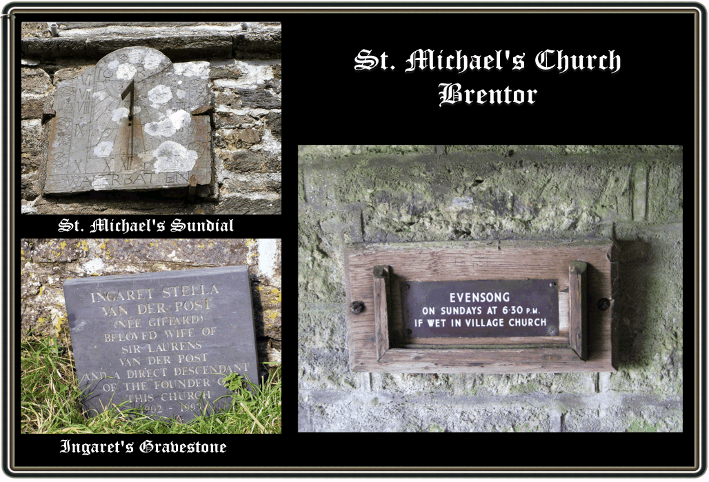
There are a couple of items of interest in the churchyard, the first being the sundial which is affixed to the southern side of the church. This is said to be one of the oldest in Devon and has a date of 1694 carved into it. There is also a depiction of what has been described as, “a quaint figure, half angel, half imp, wearing a flat cap and having outstretched wings”, Burton and Matthews, p.15 (see below) Also on the southern side of the church is the grave of Ingaret Stella Van Der Post who it is claimed was a direct descendant of Robert Giffard the church’s founder (see below). There are still services held in the church over the summer months and on festivals, indeed there is a plaque in the porch which clearly states/stated, “Evensong on Sundays 6.30 pm, if wet in village church” (see below). I would say that in the ten months this website has been in existence I must have had at least 10 emails from couples asking if they could be married in the church. Burton and Matthews, p.12, give a stark warning about weddings when they recount the story of one bride who slipped up on the wet path and went sprawling in the muck in all her finery. The other point to consider is what if it’s raining on the day, ’tis one ‘ell of a climb in a weddin’ gown.
In 1951 the first of a series of misfortunes struck the church when thieves stole 6cwt of lead from the church roof, people reckon it could have been much more but the trek down to the road put the men off. In December 1994 a bolt of lightening struck the church tower. Its force knocked down two of the crenellations on the north and west sides. A panel of wood was dislodged from the window above the altar and outside a heavy seat that was bolted to the ground was lifted off its fixings. But for some reason the stained glass panel in the window depicting St. Michael remained undamaged. On the 12th of June 2002 vandals broke in and wrecked the church which included smashing the stained glass window that depicts St. Michael, the restoration costs were estimated to be £2,000.
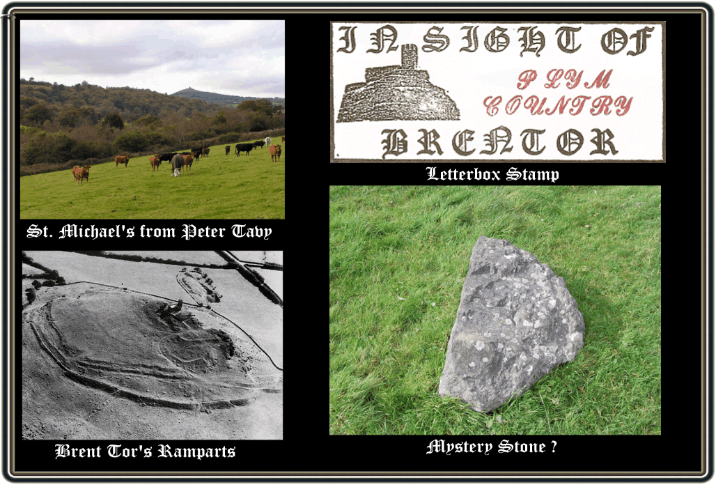
The church can be seen from Plymouth sound and has been mentioned by Risdon as “serving as a mark to sailors who bear with Plymouth haven”. But it is not only from the sea that Brentor can be seen as this view from Peter Tavy shows (see below). A few years ago a letterboxer put out a series of stamps which was called, “In Sight of Brentor”, with the boxes sited literally in sight of Brentor. It was amazing just how far across the moor these letterboxes were dispersed with some of them being where you would least expect to find them. The example shown in (see belwo) here was from the Plym country on the southern moor. It is also interesting to note that the St. Michael’s ley line runs through Brentor and in this respect a dowser and a researcher, Miller and Broadhurst, 1989, p.59 describe their visit to Brentor and the earth energies they found: “The mist grew thick: a strange sense of peace descended. There was an indefinable feeling that we were being observed. On a flattened mound, with the church above obscured by cloud, we found what we had come to think of as a node point, where the current focussed and entered the ground, accompanied by a strangely-shaped pentagram. There was a long period of silence“.
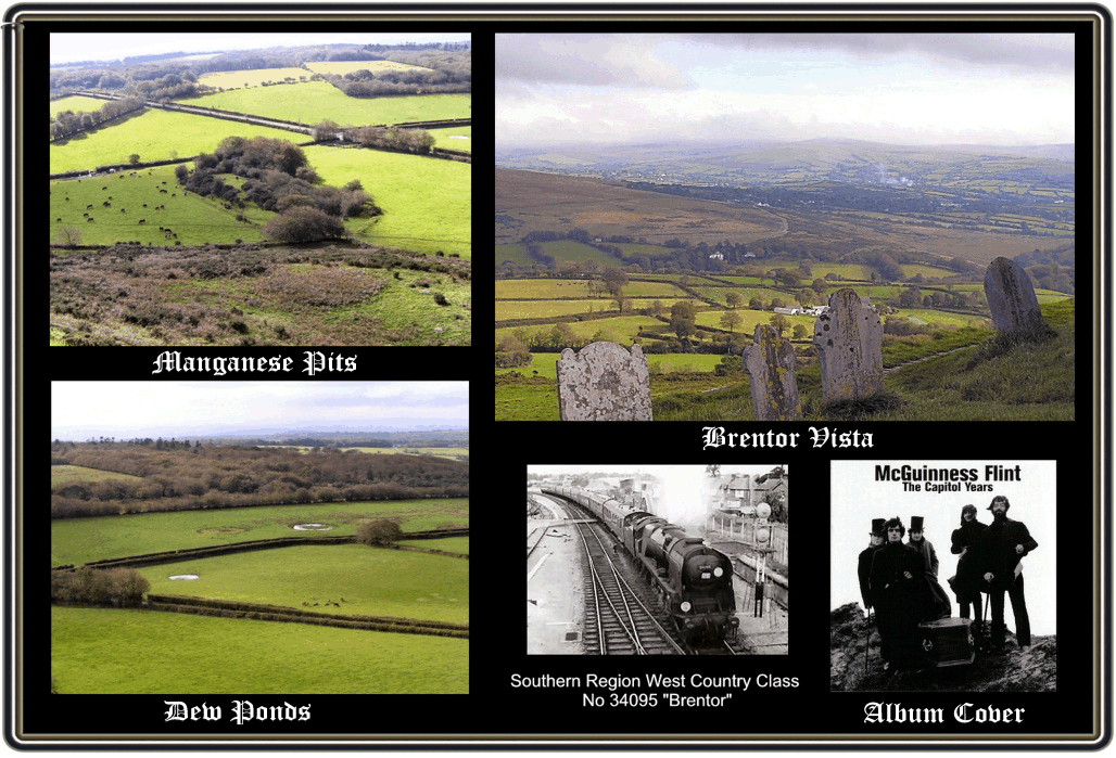
Now for the enjoyable serious stuff, Brent tor sits at a lofty height of 325m on what is thought to be part of a volcanic cone, below the tor are the remaining earthworks of what is described as an Iron Age hillfort. This has been tentatively dated to the late Iron Age (150BC – AD 50) and its earthworks can be clearly seen on any aerial photograph. It was Sabine Bearing Gould who first described the earthworks in 1900, p.102, when he said: “Brent tor was fortified in a manner very similar to Whit Tor; the outer wall remains fairly perfect on the north side, but the inner wall has been much injured. In this instance it is not the summit, but the base of the hill that has been defended. As there is a church on the summit, as also a churchyard with its wall, these have drawn their supplies from the circumvallation. Moreover it has been broken through to form a way up to the church“. So basically he is saying that the earthworks had been robbed to build the church, church yard and its wall as well as being broached to make way for a track leading up to the summit. In fact he then goes on to explain how this happened: “A late curate of Tavistock whose function it was to take the service on Brent Tor, and who found it a scramble to the summit in storm and sleet and rain, resolved on forming a roadway to the churchyard gate. But he experienced some difficulty in persuading men to go out from Tavistock to work at this churchway. However, he supplied himself with several bottles of whisky, and when he saw a sturdy labourer standing idle in the market-place he invited him into his lodgings and plied him with hot grog, till the man in a moist and smiling condition assented to the proposition that he should give a day to the Brent Path. By this means it was made. The curate was wont to say “Hannibal cut his way through the Alps with vinegar; I hewed mine over Brent Tor with prime usquebaugh”. Few traces of this way remain, but in making it sad mischief was made with the inner wall of the fortress“. Following this very little further comment was made of the feature and if it was it was only in passing. In 1996, Aileen Fox published her book; ‘Prehistoric Hillforts in Devon’ and even she had little to say: “The Iron Age fortifications are visible on the north-east and south, consisting of two close-set ramparts and ditches with an interned entrance worn and spread. A third line with stone facing lower down the slope appears to be a later property boundary. Most of the site has been dug over for manganese“, p.23. In 1996 T. Greeves undertook a survey of the area which revealed a series of secondary enclosure banks and what he considered was a number of small, terrace type enclosures suggestive of house platforms, pp. 8-10. A few years earlier he had suggested that his discovery of an early structure measuring 15.3m by 4m could be an early precursor for the present-day church, 1999, p.24. This theory was later expanded in 2003 to suggest that the structure may also be an high status hall that served as the winter residence for a Dark Age Dumnoniian chieftain, 2003, p.10. In addition he postulates that there is clear evidence for around 30 early structures clustered in two groups around the tor which he also proposes an early medieval date. In 2003 the Dartmoor National Park commissioned English Heritage to carry out and produce a proper survey and report of the earthworks on Brentor and good old E.H. sent Phil Newman along to do the work. A brief synopsis of the findings from the report Newman, 2003 pp. 1-16, begins with the rampart, this comprises of a substantial earth bank which hugs the contour in an arc shape that runs along the north and north-eastern base of the tor for 216m (see below). The inside of the bank consists of a low wall bank of about 1m in height above the ground. Outside the bank takes on a definite rampart appearance which has a steep, artificial slope of up to 5m high. For some strange reason the rampart was never finished as it extends along about three-quarters of the eastern bend of the tor’s base. This would lead to the possibility that it never was intended to form a secure boundary? The remaining gap was sealed at a later date with a wall bank of smaller proportions which it appears was done to make an enclosed field boundary. The other odd thing about the rampart is that one would expect to see an external ditch which would have been the source of the banks building materials. The entrance to the enclosure would have been at the north-west end of the ramparts where the present-day path winds its way up to the tor. Once inside the area encompassed by the rampart are a series of linear earthworks which have no banks or ditches this would suggest that they are not another series of ramparts. Newman describes them as, “two parallel, steeply cut scarps with uneven sides and bottoms”. They run from just east of the church pathway and run in a straight south-easterly line which then deviates to the south and eventually joins up with the natural scarp on the lower slopes of the tor. The interior of the enclosure has a series of banks on the moderately sloping north and north-eastern side of the churchyard. Less prominent earthworks exist along with two curvilinear banks which partly enclose a section of the slope and numerous rectangular hollows and raised platforms that Greeves considers are building platforms. There are also various parallel banks which could have been buildings or animal pens (and note animal pens). There have been a several archaeological finds in the area which include an Iron Age stone loom weight (ADS Record ID – NMR_NATIV_438132) and a stone coffin dated to the Prehistoric or Roman periods (ADS Record ID – NMR_NATINV-438133) both of which were found between Brentor and nearby North Brentor. So after that very concise description what does it all mean? Basically the rampart or lower bank is the most likely candidate for an Iron Age feature and represent an incomplete defended site. Similar features can be seen at other Dartmoor Iron Age sites such as Cranbrook Castle, Hunters Tor, Nattadon and East Hill. All have in common the fact that the ramparts were highly visible from the hillforts main approaches and entrances and were the most completed sections. Why the ramparts were never finished is a difficult question but Newman gives three possibilities, firstly the people living here couldn’t organise the required resources or labour to complete the task, secondly, for some reason there was no longer any need for a protected and defended site, or thirdly, the ramparts were a ‘cosmetic’ feature that simply produced the facade of a defended site. As far as the many internal features of the enclosure go, Newman, states that they are hard to interpret and date. He also notes that, “some of Greeves’ depictions of the earthworks as, “foundations of single room structures”, are perhaps a little optimistic, particularly those within the inner enclosure…”. He also adds that it is very unlikely that these features are associated with any Iron Age settlement that may have been located on Brentor. It is also pointed out that, “Greeves’ suggestion that the remains signify a Dark Age settlement is attractive but based on little evidence”. There is also the fact that if such a settlement did exist during the later medieval period then considering its size there should be some form of documentary evidence – there isn’t any. One suggestion that Newman puts forward is that the groups of earthworks are in fact the vestiges of old semi permanent buildings that were used at the three day, annual Michaelmas Fair that was held on the site between 1231 and 1550 – which I like the sound of and brings us nicely to the next topic. But before moving on, should anybody want to see the full English Heritage Survey Report it is available from their website (see bibliography) for the bargain price of £5.
It was not unusual for annual fairs to be held on the site of prehistoric earthworks and Brentor was no exception. In 1231 Abbot John of Rochester paid five marks for an annual three day Michaelmas fair to be held on the vigil, feast and morrow of the Archangel. The fair continued to be successful and it was recorded that in 1536 the fair was valued at 6s. 8d. but by about 1550 it was moved to nearby Tavistock, Burton, C. K. & Matthews, G. L. 1981 p.20. Therefore having established that there was a fair on the site for 319 years it is very plausible that as Newman, p.15 states, “If this fair had been held annually for 300 years it is quite possible that some semi-permanent timber structures could have been erected, such as sheep pens, and that earthworks would have resulted from erosion within and around them“. Connected with the fair was the tradition that at the foot of the tor stood a stone which was considered to be the base of a medieval cross. It was on this stone was erected the pole on top of which was the hand or glove used to signify that the fair was underway. It was also a sign of the King’s pledge to protect everyone who visited the fair honourably and that the terms of the fair charter would be upheld. This was first mentioned by Bray, p.252 when she remarked that: “The stone still lies beside the road side, on which the pole with a glove, the usual concomitant of a fair was erected. Probably however it was originally, the base of a cross“. Sadly by 1892 the stone had gone missing as Crossing stated: “The Stone has now disappeared, and I can learn nothing whatever of it”, Crossing, 1987, p.115. There is an interesting stone to the left of the church track which has been obviously worked and split in half, it seems to be out of context with any nearby rocks and although it looks nothing like a cross base it’s still is puzzling (see below).
Clearly most of the above legends are totally implausible in these modern times, the very idea of the Devil demolishing structures is unthinkable. However, it cannot be denied that Brent tor would have certainly proffered itself as the focus for a sacred site. The one time presence of an Iron Age settlement would in itself suggest that apart from its defensible position it would lend itself to pagan worship. The Iron Age element could also be responsible for the pagan inhabitants in the third version of the legend.
Just a final few observations, from the top of the tor there can be seen a few enigmatic features. To the north-west of the tor lies an interesting feature (see below) which is thought to be the remains of manganese extraction and to the north are three dew ponds (see below) which according to some can be a prehistoric feature. I would thoroughly recommend a visit to this site, preferably in the winter or spring when it is quieter. Regardless of the weather it will be found to be a place of mystery. On a fine day the views are spectacular (see below) and on a wet, misty day the atmosphere is one of solitude and wonder. Brentor has appeared in many photographs, drawings etc and in the 1970’s it appeared as an album cover to ‘The Capitol Years’ by the band ‘McGuinness Flint’. On the cover the band are pictured with a coffin standing below the church. The back of the album shows some people in Victorian dress standing infront of the church (see below). Another claim to fame is that back in the 1960’s the southern region named a West Country Class steam engine ‘Brentor’ it was number 34095 (see below)
Sadly the last word on Brentor is one of caution, so be warned. As you will see from the last illustration on my last visit a week ago I saw the sad remains of someone’s car window (see below). This is all that remains from a car break-in and is very common in the Brentor car park, so don’t leave any valuables in sight and securely lock the doors. You won’t have time to run down from the tor should your car alarm signal a break in.
Oh I nearly forgot, the place-name, dear Mrs Bray, 1844, p.251 offers the theory that Brent is the participle of brennan which means ‘to burn’ and so Brent Tor is a corruption alluding to the supposed signal beacon that once was located on the tor. However, in Clarke Halls ‘Concise Anglo Saxon Dictionary’, p.55 he lists the word, “brant” which meant; high, steep or deep. This would seem more logical as the mutation form Brant Tor to Brentor is slight and would aptly give a topographical place-name of ‘the steep/high tor’. A theory supported by Gover et al, 1992, p.213 and Ekwall, 1980, p.63. If you can’t manage to get to Brentor then the painting below by David Young is the next best thing.
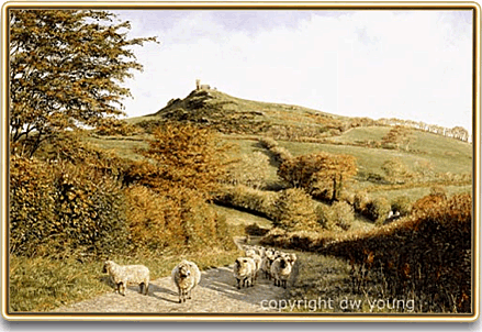
By kind permission of David Young
For more superb Dartmoor works of David visit his website – HERE
There are now some outstanding 360º images of both inside the church and of the panoramic views from the tor to be found on the Sphereworks website – HERE

Baring Gould, S. 1982 A Book of Dartmoor, Wildwood House Ltd, London.
Bray, E. 1844 Legends, Superstitions, & Sketches of Devonshire on the Borders of the Tamar & the Tavy, John Murray, London.
Bray, E. 1836 A Description of the Part of Devonshire Bordering on the Tamar and the Tavy, John Murray, London.
Burton, C. K & Matthews, G. L. 1990 Saint Michael of the Rock, Privately published.
Clark Hall, J. R. 2004 A Concise Anglo-Saxon Dictionary, University of Toronto, Canada.
Crossing, W. 1987 The Ancient Stone Crosses of Dartmoor, Devon Books, Exeter.
Daniell, C. & Thompson, V. 1999 Death in England, Manchester University Press, Manchester.
Ekwall, E. 1980 The Concise Dictionary of English Place-Names, Oxford University Press, Oxford.
Finberg. P. R. 1969 Tavistock Abbey, David & Charles, Newton Abbot.
Fox, A. 1996 Prehistoric Hillforts in Devon, Devon Books, Exeter.
Gover, J.E.B., Mawer, A., & Stenton, F. M. 1992 The Place-Names of Devon, The English Place Name Society, Nottingham.
Greeves, T. 1999 Church, Parish and Boundary, The Dartmoor Magazine Vol. 57, Quay Publications, Brixham.
Greeves, T. 2003 Was Brentor a Dark Age Centre, The Dartmoor Magazine, Quay Publications, Brixham.
Griffith, F. 1988 Devon’s Past an Aerial View, Devon Books, Exeter.
Newman, P. 2003 Brentor: An Earthwork Site on Western Dartmoor, English Heritage,, Swindon
Miller, H. & Broadhurst, P. 1989 The Sun and the Serpent, Penwith Press, Cornwall.
Morris, R. 1989 Churches in the Landscape, Phoenix Giant Publications, London
Orme, N. 1996 English Church Dedications, University of Exeter Press, Exeter.
Parker Pearson, M. 1999 The Archaeology of Death and Burial, Sutton Publishing, Stroud.
Pevsner, N. 1952 The Buildings of England – South Devon, Penguin Books, Middlesex.
English Heritage 2006 – Online source at: English Heritage
When reading everything that you have written about the church on the tor I was delighted to read about weddings that took place there. My parents (Hamling) Were married there on 2nd April 1949 and it was my mother who slipped and fell on her way out of the church.It was a story that has been fondly told overy the years. I myself lived in Brentor until I was seven years of age when the Railways closed and Dads job moved us to Truro. we fondly return to Brentor to visit.
Tim,
We changed the times of the “summer” services at St. Michael to start at 6 pm a couple of years ago now. (This helps at the beginning & end of the season when light at the conclusion of the service can be at a premium. Evening services actually run from Easter through to Michaelmas, falling appropriately as it does at the end of September). Weddings continue to be a major feature!
We had an echo of the 1887 event with last Sunday’s beacon commemorating the conclusion of the Great War & we are beginning to turn thoughts to next year’s 700th anniversary.
Best wishes,
Nick Butland (Mary Tavy)
Within the featured text, Pevsner states that the dimensions of the church are 40 x 14ft, whilst Burton and Matthews state it to be 37 x 40ft; should the latter dimensions perhaps read 37 x 14ft?
Good morning!
I have a curiosity itch that I cannot find any information on and hop you may be able to help!
It appears on one end of the church, under the structure, there is a gated entrance – it appears to be a crypt?
We were unable to get close enough to peer inside but my partner and myself are desperate to find out what it is!
I hope you are keeping well and can help.
Thank you,
Chrissie B.
It is the crypt and it was aid that due to the geology of the tor the crypt got flooded in times of heavy rain and the coffins inside would be found to be floating in the water?