 Legendary Dartmoor The many aspects past and present of Dartmoor

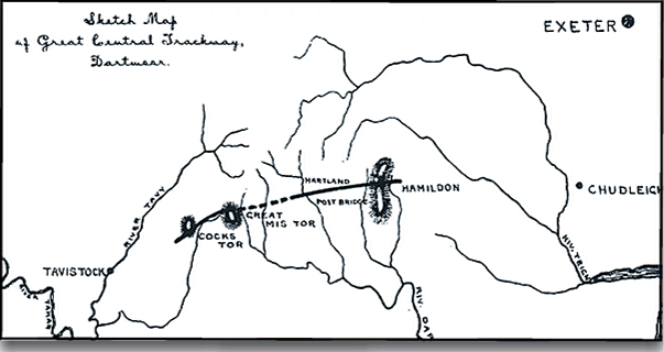
Today the general consensus is that the Romans never ventured very far onto Dartmoor however just over 100 years ago there was a strong theory that in fact the famous Fosseway Roman road crossed the moor as it went from Exeter to Tavistock. This route became known as the ‘Great Central Trackway’ and serves as an excellent example of how one man’s idea can impact on the understanding of the historical landscape.
“The most extensive and important trackway which has come under our notice, is one which is supposed to traverse the Forest in a line bearing east and west from Hameldon to Great Mistor. Considerable portions of the line can be traced in a direction corresponding to these points, but a large extent of it rests rather upon the testimony of tradition than upon the evidence of existing remains. The oral topographers of the uplands (Rev. J. M. Mason) recognize this trackway as the equator of the moorland region, all above it being circumstance which, though it affords good evidence of the antiquity of this relic, might supposed to give it the character of a boundary rather than a road, but which will have less weight in this scale when we consider how frequently ancient roads are found to form boundaries between parishes, manors and other divisions of the country This trackway may be observed in high preservation, coming down the northern slope of Chittaford Down towards the banks of the East Dart. Here it can be traced for a considerable distance, and is visible due west through Hollocombe, and up the opposite hill to Lower White Tor, down the common towards the Dart, it bends north-east, but in the level near Post Bridge it takes a direction southward. With some difficulty it may be detected through the boggy meadows below Hartland Farm. The peat-cutters are reported to come upon it below the surface in some places; nor is it all unlikely that the encroachments of the vegetation, which in some instances are only partial, should in others have extended over the whole breadth of the trackway, and thus have obliterated all traces of it in the lower grounds. This trackway has been commented on by Mr. R. N. Worth and Mr R. Burnard; by the latter it has been carefully traced and surveyed, The conclusion which these gentlemen have arrived at, upon evidence which is impossible to resist, is that it formed a portion of the great Fosseway, the British road which the Romans found and utilised“, (Rowe, pp. 62 – 63). The above extract comes from Rowe’s book that was first published in 1848 and then revised in 1896, I would suggest that this was part of the revision for reasons that will become clear later.
The nineteenth century was the heyday of the noted Dartmoor Antiquarians who formed part of the Dartmoor Exploration Committee which began the first serious studies of Dartmoor. Some of these are the same people who attributed the building of stone circles, stone rows, menhirs etc. to the Druids which at the time became taken as read. So just maybe it could be concluded that Rowe, Burnard and Worth were some of the more forceful opinion leaders of the committee and that their ideas soon became widely adopted? Fleming even notes that ‘It is interesting how one fixed idea can influence the direction which archaeological fieldwork will take‘, (p.27).
So basically the theory was that there was supposed evidence of a trackway (which became known as The Great Central Trackway) that lead across the central portion of the moor and was an extension of the famous Roman road, The Fosseway. It is also interesting to note how Rowe refers to the Fosseway as ‘the British road which the Romans found‘. I’m pretty sure that the Roman soldiers who sweated and toiled to build that road would have something to say about it?
As Rowe pointed out, Robert Burnard did indeed survey the trackway and described what he found thus:
It is a fine deposit of handy stones, and has been extensively drawn on by the inhabitants of the Moor. In Webb’s Marsh at Post Bridge the trackway is thus utilized, and it was from this point that I determined to start my investigation in a westemly direction. Here the removal of the stones has exposed a good section of the causeway, and it will be observed that the width of the paved way is just ten feet, whilst the depth in the centre is about two to two and a half feet. Rough stones, just as they are found on the surface, have been rudely built in so as to form a solid bottom. There are no traces of the covering of finer material forming the surface, but this could easily have been supplied by means of gravel’, (T.D.A. p. 432).
The above extract comes from a paper written by Burnard which appeared in The Transactions of the Devonshire Association of 1889. For Rowe to comment on this survey only means that his comments came from the revised version of his book written in 1896. In his paper Burnard goes into a lengthy description of the trackways route which basically suggests that The Great Central Trackway ‘heads for Exeter, via Chudleigh, on the east, whilst it undoubtedly proceeded to Tavistock on the west, and thence through the Tamar on into Cornwall, where, I have reason to believe, it has already been observed, but not recognized. This road was for through traffic, and its course and continuity is such that its identification with the Fosseway is complete’, (T.D.A. p. 436).
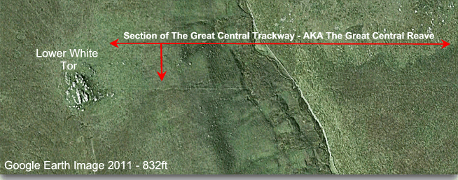
A central section of Burnard’s survey – T.D.A 1889, p.437.
The topographer J. Ll. W. Page in his book published in 1895 also picks up the thread when he says: ‘Between Longaford and Lower White Tor may be traced some portion of the great central trackway, which extended, it is thought, right across the forest from Hameldon to Great Mis Tor… in the opinion of Mr. R. N. Worth, it is not a British but Roman road. He regards it as the line of the Fosseway, and considers that it ran from Exeter to Tavistock…‘, (p. 163).
So, there we have two eminent antiquarians and a topographer of their time postulating that the Romans built an extension of the Fosseway across Dartmoor that ran from Exeter to Tavistock and then on to Cornwall. Presumably one possible reason for this route that might have been suggested at the time was for the transportation of Cornish tin?
Another eminent Dartmoor expert of the time was Sabine Baring Gould and writing in 1900 he states that: ‘The great central causeway crossed the modern road near the Dissenting chapel and may be traced in the marsh aiming for the river, beyond which it ascends the hill and strikes along the brow behind Archerton. It is paved, and is a continuation of the old Fosse Way. It is certainly not Roman work but British‘, (p.242).
Both Rowe and Burnard make a distinction between ‘The Great Central Trackway and what they call ‘Tracklines’, Burnard states: ‘It is very probable that the long tracklines that extend over hill and vale on Dartmoor indicate tribal boundaries, limits beyond which the cattle of one might feed’, (p.47). Rowe also makes this distinction by also stating: ‘ Greatly similar in construction (to the trackway) are the Tracklines or Boundary Banks, which are invariably observed in connection with aboriginal dwellings and sepulchral remains‘, (p.63).
So close and yet so far, it finally took the esteemed writer William Crossing to recognise that:
‘Trackline is a name that has been given to them (boundary banks) but not very happily, as it suggests that they were formed to serve the purpose of marking a track, which they were certainly not. There are those that consider that the larger examples were roads and have given to them the name of trackways. I confess that I have never been able to regard them as such, and until it is explained how those who used them contrived to ride through rocks, or immense cairns I am unable to accept the view that they were designed for the purpose of traffic‘, (p.32).
There is no sense greater than common sense and here Crossing demonstrates such by simply asking the question of why a trackway should end abruptly at a tor or some such impassable feature? He further adds when discussing a ‘trackway’ Chittaford Down; ‘No explanation has been offered why this so-called trackway should be carried straight into a tor, and none, in fact, could be given unless the tor were it’s terminal point‘, (p. 33). The above extracts were published in 1909 and were taken from the section called ‘Terms used in connection with the forests and commons’ under the heading of ‘reaves‘.
In later years various people such as Andrew Fleming have proven that the ‘Great Central Trackway’ along with other trackways and tracklines are in fact all prehistoric boundaries. Today, in it’s correct context the ‘Great Central Trackway’ is known as the ‘Great Central Reave’.
The fanciful idea planted by Worth and propagated by others that the Fosseway extended over Dartmoor is now regarded as fiction rather than fact. But this instance does show how the ideas of one person can become accepted and adopted for a good 100 years or so when supported by enough eminent people of the field.

Baring-Gould, S. 1982 A Book of Dartmoor, London: Wildwood House.
Burnard, R. 1889 The Great Central Trackway, Transactions of the Devonshire Association – Vol. XXI.
Crossing, W. 1990 Crossing’s Guide to Dartmoor, Newton Abbot: Peninsula Press.
Fleming, A. 2008 The Dartmoor Reaves, Oxford: Oxbow Books.
Page, J. Ll. W. 1895 An Exploration of Dartmoor, London: Seeley & Co.
Rowe, S. 1985 A Perambulation of Dartmoor, Exeter: Devon Books