 Legendary Dartmoor The many aspects past and present of Dartmoor

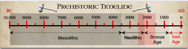
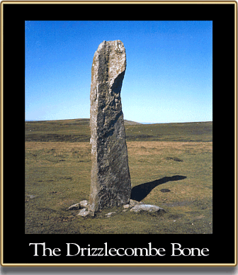
Perched just above the little valley known as Drizzlecombe or Thrushelcombe is what in some circles is known, for reasons that will become clear, as ‘The Bone‘. This is one of three menhirs (standing stones) associated with the scheduled Drizzlecombe ceremonial complex and itself is part of a feature consisting of a 85.4m long stone row and a cairn. Officially scheduled as Monument No, 438619, the menhir has the accolade of being the tallest menhir standing on Dartmoor today, some folks even suggest that it is the biggest monolith in England? Following various reports and surveys the menhir is often referred to as, ‘Menhir C’ (the other two in the group are A and B) or The Great Menhir. Nobody is exactly sure of its age but the menhir slots somewhere between the late Neolithic and early Bronze Age periods:
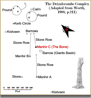
Worth, (1988, p.209) considers that the Drizzlecombe prehistoric remains are: ‘The most neatly arranged group on Dartmoor, and, with the possible exception of Merrivale, the sole example which shows what by our modern standards would be regarded as planning‘. Just how neatly they were planned and what position ‘The Bone’ takes within the group can be seen from the plan below which was adapted from Worth’s original record:
This page is concerned with just one aspect of the Drizzlecombe complex so now to focus on ‘The Bone’. Above ground, its mighty proportions stretch up to a lofty 4.2 metres high and has a shape-shifting capacity when viewed from varying sides, one of which could be likened to a ‘bone’, hence the nickname. When Worth surveyed the complex in 1889 he found that all three of the associated menhirs had fallen down which allowed him to take its measurements:
‘Menhir C was 17ft 10in. long, 4ft wide about, 3ft 6in. from the wider end, but tapering to that end, and 2ft 7in. wide at the narrower end, its thickness about 1ft 2in… At the head of the menhir there is a curious excrescence on one side; this is purely natural, the effect of the jointing of the granite‘, (Worth, 1988, p.268).
It has been estimated that this granite pillar weight in the region of 6 tons and was somehow transported from Higher Hartor Tor which lies 1.25 km to the north east of its final location. On the 21st and 22nd of July 1893 Robert Burnard, Richard Hansford Worth, Mr. W. A. G. Gray and the Reverend Hugh Breton oversaw the re-erection of the three menhirs. The actual work was carried out by Messrs, Turpin and Sons from Plymouth who located the original socket hole and sunk the menhir in it along with some concrete, (Burnard, 1986, Vol. IV, p.61|).
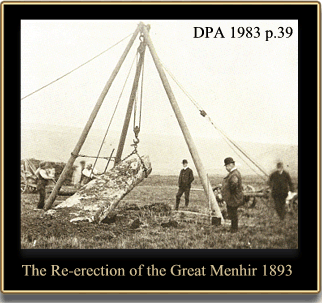
Once erected ‘The Bone’ stood at 14ft high and measured 4ft 2in, by 1ft 2in. at ground level, (Worth, 1988, p.268). This converts to 4.267 2 metres which is well within the range of 4.2m – 4.3m which are variously cited today this would indicate that the re-erection procedure and the concrete have ensured that the menhir has not sunk into its socket hole. It also means that below ground lies roughly a quarter of the pillars length which seems surprisingly less than would have been expected.
For the astro-archaeologists, the stone row to which ‘The Bone’ is connected actually orientated 42º east of grid north and at 3.00pm on the Winter Solstice (21st of December) the pillar’s shadow aligns with its stone row. It has been suggested that if any ceremonies were carried out to mark the Winter Solstice at Drizzlecombe then ‘The Bone’ and its alignment would be the first to signal the commencement of the ritual, (Walker, 2005, pp. 55 – 56).
In recent years some carved graffiti has appeared on the great menhir which has caused come controversy, from what I can ascertain the strange characters have their roots in Hong Kong and spell the word ‘Ashley’. This is a far cry from some archaeologists theory that they were some mystic, prehistoric hieroglyphs, – for the full story see – The Drizzlecombe Enigma.
Oh, and if you are wondering where the place-name of Drizzlecombe comes from and what it means then here’s the answer. Despite various interpretations such as: dur-iz-el (Enduring Light God) and ac-om-be (Great Sun Father) thus giving the place of ‘The Enduring Light of God the Great Sun Father’, the reality is far less dramatic. William Crossing (1990 p.434) informs us that:
‘Thrushel Combe is locally called Drizzle Combe, and this name has been generally adopted, and figures on the Ordnance Survey map. But on the copy of an old map in my possession, which I have every reason to be authorative, the valley is shown as Thrushel Combe, and there can hardly be a doubt that this is the correct name. It is easy to understand how it would become Drizzle Combe in the Dartmoor vernacular’.
I would suggest that this is not quite correct and without explaining why Hemery too thinks along the same lines. He records an alternative name of, Dreshel or Drishel-cum’ for Thrushelcombe, (1983, p.186). Now, the old dialect word for a thrush is – Drish, (Hewett, 1892, p.74) which would soon mutate into Drishel Combe meaning the ‘valley of the thrush’.
Reference.
Burnard, R. 1986. Dartmoor Pictorial Records. Exeter: Devon Books.
Crossing, W. 1990. Crossing’s Guide to Dartmoor. Newton Abbot: Peninsula Press.
Dartmoor Preservation Association. 1983. A Dartmoor Century 1883 – 1983. Yelverton: D.P.A.
Hemery, E. 1983. High Dartmoor. London: Hale Publishing.
Hewett, S. 1892. The Peasant Speech of Devon. London: Elliot-Stock
Walker, J. 2005. Dartmoor Sun. Tiverton: Halsgrove Publishing.
Worth, R. H. 1988. Worth’s Dartmoor. Newton Abbot: David and Charles.
I’m researching a historical novel and wonder if you could tell me how far Drizzlecombe is from Lewtrenchard? And how far are the stones from yelverton?
According to the AA route planner it’s 18.9 miles to Brisworthy Stone Circle which is then, as the crow flies, 1.9 miles to Drizzlecombe. Yelverton is 5.1 miles from Drizzlecombe as plotted on Memorymap.
Much appreciate the Drischel Combe explanation. A lot of old places lose their names when people no longer think of the road or town as remarkable for a specific reason.. I live near ‘Federal Twist Road” a 5-6 mile modestly paved road running through forest and fields in a rural 35 sq mile township with rudely built old stone walls and the occasional house. It has more than a few curves and a long descent into a valley. I always figured the name relate to topography or government use- turns out it was the name of a popular 19th C chewing tobacco and a farmer made a few bucks allowing its logo to be painted on his barn. Lots of area residents still don’t know this.