 Legendary Dartmoor The many aspects past and present of Dartmoor

‘Westward we have that beautiful ravine called Tavy Cleave, through which the river beneath leaves its mountain home, overhung on the one hand by a succession of rocky pinnacles, of which Great Tor – locally Gert Tor – is the boldest, and on the other by the steep bluff of Stannon Hill. Midway is the solitary wind-twisted tree called Watern Oak, which has been so often hailed with delight by the moor-man lost in a fog.’, (Page, 1895, p.103).
As always, begin with an introduction – Watern Oke as marked on the modern Ordnance Survey maps or as seen above, Watern Oke, is it a tree or a description? If you believe William Crossing then it is a description for he contends that: ‘the name is traceable to a Celtic root, ‘osc’, signifying ‘water’.’, (1994, p.85). Well, that may explain the ‘Oke‘ element but what about the ‘Watern‘? About 7 kilometres to the north east of Watern Oke is Watern Tor and the ‘Watern’ element of this place-name is thought to have derived from a corruption of Waterdon which means Water (water) Hill (dun) thus giving the ‘tor on the watery hill, (Gover, 1992, pp.197 – 198). Therefore taking the consensus of opinion we have ‘water hill of the water‘ which is utter nonsense, alternately the logical explanation is that there was indeed a ‘solitary, wind-twisted tree standing by the water‘, hence Watern Oak, which has then become mis-spelt as Oke and adopted for future generations. The Ordnance Survey 1:10,560 – Epoch 1 map of 1889 certainly records, ‘Watern Oak’.
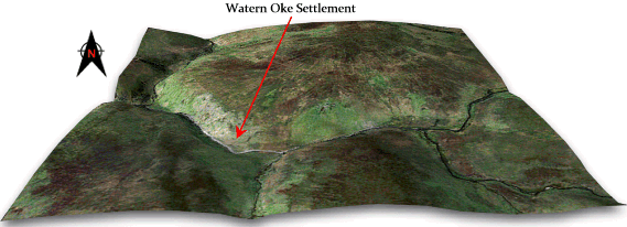
So what is so special about Watern Oke apart from the scenery, abundance of water and seclusion? Basically, during the Bronze Age this could be regarded as a ‘new town’ of its era and was one of the larger settlements on the north moor. As can be seen from the 3D map below the settlement was located along the southern slopes of Amicombe Hill just above the northern banks of the River Tavy. Fox, (1973, p.101), has described Watern Oke as an open village settlement, ‘in which the huts are linked by low walls forming irregular enclosures, that could be used for cultivation or for stock.’ For some strange reason English Heritage classify Watern Oke as a , ‘Hut Circle Settlement’ belonging to the Iron Age when there is no evidence to suggest this whatsoever.
The western group was excavated in 1905 by the Dartmoor Exploration Committee when 94 of the huts were excavated by Anderson. It appears from the English Heritage field investigators’ comments that the work was none too professional as in 1995 he made the following comment: ‘None of the excavations seem to have been backfilled and many of the huts were so badly reconstructed that they now appear somewhat rectangular in plan.’, (EH. 2009 – online source). Apparently the excavation was carried out by eight diggers and took about 2 months to complete. The diggers lived out on the moor throughout the excavation and encountered some of the harsh Dartmoor weather, so harsh in fact that on two occasions their tents were blown away. At the end of the work a fairly decent plan of the settlement was produced which described the huts as belonging to one group. Butler (1991, p. 101) however, considers that there are three seperate and independent groups; the eastern group, central group and the western group which is by far the largest and consisted of around 78 huts, most with connecting walls, The majority of the huts can be considered in Dartmoor terms as being on the small side with internal diameters which range from 1.8 – 5.2 metres. Where discernable the hut entrances tend to be located in the south and east quadrants which would face away from the prevailing south westerly weather, (EH. 2009 – online source). The excavation work of 1905 produced finds in most of the huts which comprised of large amounts of charcoal, cooking stones, pottery sherds, flint artefacts, whet stones, chunks of rough quartz and even possibly sling shots. The discovery of quartz was interesting as some of it comprised of crystals that were pointed and blunted by apparent use which would indicate they were using them as some kind of tool? The large quantities of whet stones indicates that there was certainly metal tools or weapons of some kind being sharpened. Similar large amounts of what the report called ‘rubber stones’ and ‘pounding stones’ were found suggesting that some material was being ground down on the rubber stones – was this grain or some kind of metal ore? Some of the pottery fragments have given a suggested date from c. 1400BC and show a rare pattern of decoration which consists of plaited cord and twisted cord impressions and various incised decorations, (Pettit, 1974, p.78). In addition a Romano-British melon bead was found which dates to around the 1st or early 2nd century AD. This was sent to the British Museum for their opinion and the following was reported back: ‘I think the bead old. It most nearly resembles one from Water Newton Huts, found with Roman remians of the second century or thereabouts; and one from Thebes in Egypt, of no certain periods, but doubtless Roman also,’ – Mr Head, British Museum.
The central group consisted of 11 huts which appear to have been constructed in a some what more robust manner to those of the western sector but all produced finds similar to their counterparts. The eastern cluster was different again insomuch as the 6 huts were smaller and what could be described as a much cruder build, (Butler, 1991, p. 109).
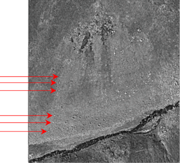
It is possible today to discern the three groups and about 70 of the associated huts from aerial photographs, some of which are remarkably identifiable – see opposite.
What is remarkable about the Watern Oke settlements is that there are no ritual monuments such as cairns, stone rows or circles within a one kilometre radius of the site. There is an argument that at some period in the Middle to Late Bronze Age there was a collapse in the religious belief system due to failing crops, starvation and general unrest. In effect it was as if the people turned their backs on whatever Gods they were worshipping and all the associated rites and ritual monuments. It is just possible that these settlements were established at a time in the Late Bronze Age when the population had no need or belief in such monuments hence the reason for there not being any?
One final point, when the area above the central cluster of huts is viewed from the air there does appear to be a line of stones running in a fairly straight line down the hillside as can be seen from the photo below:
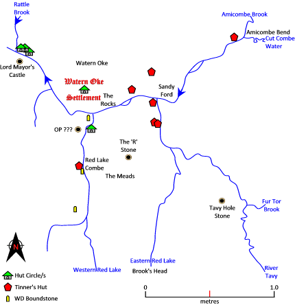
There is one other fanciful idea connected with Watern Oke and that concerns tin, as can be seen from the above map there are a number of medieval or post-medieval tinner’s huts located around the Watern Oke area. Tinner’s Huts mean that at one time tin ore was to be found in the stream beds. The excavation of 1905 revealed, ‘considerable amounts of charcoal‘ from within the huts and to extract the tin one needs a heat source, could it be that there was some tin processing going on at Watern Oke during the Bronze Age? In 1982 a theory was muted by D. G. Price (1982, p.27) that there is, ‘some correspondence between the distribution of settlements and that of tin deposits.’ There was also a comparison between the size of hut clusters (referred to by Price as ‘complexes’) and the distance to known tin workings, this clearly demonstrated that the larger complexes of 25 or more huts were always within 174 metres of tin workings. The excavation report notes that many of the huts showed evidence of cooking either in the form of hearths, cooking stones and charcoal but there was one hut which was described thus: ‘Hut Circle 46a. – This was evidentially a cooking place, constructed amongst the rocks, impossible to measure or delineate, for it had no shape; it contained much burnt granite.’ Why would there be a need for a seperate ‘cooking place’ when so cooking took place inside so many of the huts, was it cooking at 46a or smelting?

Crossing, W. 1994. Echoes of an Ancient Forest, Liverton: Forest Publishing.
English Heritage, 2009. Pastscape Record – Watern Oke Settlement, Online source – HERE
Fox, A. 1973. South West England – 3,500 BC – AD600, Newton Abbot: David & Charles.
Gover, J, Mawer, A. & Stenton, F. M. 1992. The Place Names of Devon. Nottingham: English Place-Name Society
Page, J. Ll. W. 1895. An Exploration of Dartmoor and its Antiquities, London: Seeley & Co. Ltd.
Pettit, P. 1974. Prehistoric Dartmoor, Newton Abbot: David & Charles.
Price, D. G. 1982. Investigation of Prehistoric Settlements on South West Dartmoor. In Transactions of the Devonshire Association – Volume 114.