 Legendary Dartmoor The many aspects past and present of Dartmoor

Staldon stone row is the longest stone row on Dartmoor but there can potentially be a slight mix up with the much shorter row which lies 1.88 kilometres to the south on Stalldown. This is a good example of the dangers of place-name etymology as Staldon is a local dialect corruption of Stalldown thus presenting two separate locations with very similar names. To compound this even further various topographical writers have fallen into this trap which means one has to be very careful when reading their descriptions. Incidentally the name Staldon/Stalldown derives from two old English elements; dun meaning hill and steall meaning standing place or animal stable/stall, Gover et.al, p.270. Thus giving the animal stall of the hill or basically a place on the hill where cattle or horses were kept which given the number of prehistoric settlements in the area is quite logical. As the southern end of the Staldon row lies on the flank of Bledge Hill it would be a lot less confusing to refer to it as the Bledge Hill stone row?
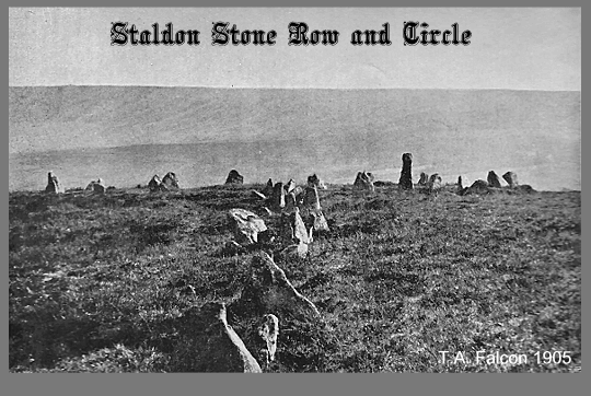
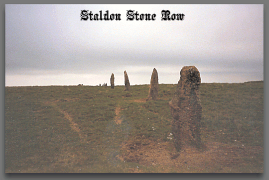
The stone row begins at a stone circle located on Bledge Hill, OS grid reference SX 6351 6444 at a height of 371 metres and runs in a northerly direction to its northern terminal at a cairn located on Green Hill at OS grid reference SX 6366 6779 and a height of 473 metres. As noted above this is the longest stone row to be found on Dartmoor and some even suggest it’s the longest in Europe if not the world?
So beginning with the stone circle, this is known by various names on the moor; ‘The Dancers’ and ‘Kiss in the Ring’ and for an explanation see – HERE. The stones describe a circle which is 15.8 metres in diameter and surrounds a low barrow mound, there are 26 stones remaining, 10 in the eastern half and 16 in the western half. The entire circle is enclosed by a shallow trench.
OK, a few vital statistics, reportedly the stone row is 11,150ft long which when converted into new money comes to 3.39 kilometres. Again, no two sources give the same distance, 11,150ft comes firstly from R. H Worth, p.204 English Heritage estimate 3.1 kilometres whereas Jeremy Butler suggests a distance of 3.32 kilometres, p.74, Hemery goes for 1,643 ft which equates to 0.50 kilometres (either a typo in his book or he’d been at the cider) and if traced on Memory Map it comes to 3.41 kilometres?
The stone row’s course, however long it be can at best be described as ‘irregular’ and it is not possible to see each terminus from one end to the other. The size and condition of the stones tend to get worse the further you travel towards Green Hill. There are two possibilities for this; either the row builders found it harder to find suitable stones in the peat areas or the stones have been ‘recycled’ by turf cutters or tinners
 .
.
So according to Falcon it can be assumed that the numbers of stones in the row are between 800 and 917 depending on where you accept the northern terminal as being. However, Butler suggests a total of around 1,000 survive today but originally he estimates there to have been about 2,000 stones in the row. One thing I can guarantee is that if ever you try counting them you will never get the same number twice. Very few of the stones are more than a metre in height and they are spaced between 1.3 and 1.6 metres apart ,p. 75 The initial stage of the row is orientated 3º east of north and is aligned just east of the cairn’s centre. As it route progresses the row takes a more easterly bearing and runs on an orientation of 009º. Having followed the left upstream bank of the river Erme the row the crosses over to the right bank opposite Erme Pound where it heads off on a northerly direction. On reaching Red Lake the rows veers off gently to just east of north before regaining its northerly track up to Green Hill. Throughout it’s distance the stone row passes by two cairns before reaching the final cairn on Green Hill.
The terminal cairn on Green Hill comprises an ovoid, turf-covered, stony mound which measures 9.4 metres E to W by 7.5 metres and stands to a maximum height of 0.4 metres. In the middle of the mound here is a circular depression which is 4 metres in diameter and 0.25 metres deep and a scattering of stones in this depression possibly may be the remains of a kist. There is a suggestion that perhaps at one time a Longstone or menhir was located near to the cairn and now has become buried beneath the peat. If this was the case then possibly this was intended to be the terminus of the stone row?
Back in the early 1900s there was a slight controversy regarding a possible northern terminus. Whilst today it is widely accepted that the stone row terminates on Green Hill it was suggested in 1905 that it went further northwards to Cater’s Beam. T. A. Falcon noted the following in the Transactions of the Devonshire Association:
“This sodden and exasperating district of the moor is intelligibly not overcrowded even by Neolithic enthusiasts. But it has one object interesting apart from its repellent remoteness, and that is the ruined cairn on it, which seems to be the real end of the Stall Moor stone row, terminated by the majority of descriptions positively at Green Hill. Following the row from Redlake (to which point there is no possibility of doubt, except as to the number of stones), where a cautious enumeration places the 613th stone from the circle, the row here directed W. of N., is easily traceable up Green Hill to stone No. 800, when a small square stone, set at right angles and appearing like a blocking-stone, occurs; but the row continues beyond it to No. 896. Here the depression of the Blacklane Brook males a break, but stones continue beyond it at much longer intervals, across a peat cutting, to stone No. 914, and thence, after a large gap of c. 100 yd. to 917. Cater’s Beam cairn is some score yards beyond this last stone...”, TDA 1905, p.460.
In 1979 and again in 1994 English Heritage field investigators went is search of evidence that would support Falcon’s theory. On both occasions they could find no trace of any cairn and the final suggestion was that Falcon mistook either some past tinning or peat cutting activities in the area.
The big issue with this particular stone row is why is it so different from all the other stone rows on Dartmoor if not the world? Well maybe that is not exactly true as 4.4 kilometres south of ‘The Dancers’ stone circle is another stone row which runs from Butterdon Hill northwards to Hobajohn’s Cross. Although this one is shorter with a length of about 1.97 kilometres it has been suggested that its construction and layout is very similar. Could it be that whatever the intent and purpose of both rows the concept was a local fashion or trend?

Butler, J. 1993. Dartmoor Atlas of Antiquities – Vol. 4. Exeter: Devon books.
Falcon, T. A. 1905. Dartmoor: A Note on Graves. Transactions of the Devonshire Association – Vol. XXXVII
Gover, J. E. B., Mawer, A. & Stenton, F. M. 1992 The Place Names of Devon. Nottingham: English Place-Name Society.
Hemery, E. 1983. High Dartmoor. London: Hale Publishing
Worth, R. H. 1988. Worth’s Dartmoor. Newton Abbot: David & Charles.