 Legendary Dartmoor The many aspects past and present of Dartmoor

“Back to the sunset bound of Lyonesse–
A land of old upheaven from the abyss
By fire, to sink into the abyss again;
Where fragments of forgotten peoples dwelt…“.
The above lines are how Tennyson described the legendary land of Lyonesse that sunk beneath the waves somewhere off the coast of Cornwall. But what has that to do with ‘Monks on the Moor’ one may ask? Simply this, there is a submerged monastic homestead, ‘Where fragments of forgotten peoples dwelt‘ on Dartmoor. This particular ‘Lyonesse’ lies submerged beneath the waters of the Avon Reservoir and here it has a comparison with the legendary village of Brigadoon which appears briefly every hundred years and then vanishes again. This occurrence happens in exceptionally dry years when the reservoir’s water level drops low enough to briefly reveal the ruins of the old monastic homestead. But what where monks doing on the moor and when were they there? Both archaeology and historical documents provide the answer and in some cases it shows that the monks once living there were not the pious Christians that one might expect.
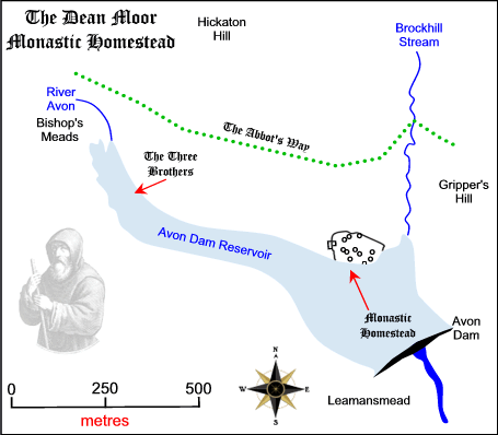
The homestead originally (prior to the flood) was situated in a remote area of what was then Buckfast Moor (now Dean Moor) and was occupied during medieval times. The site seems to have been chosen because of its available shelter, the nearness to a water supply and nearby verdant grazing. Another factor that may have contributed was the handy supply of building stone and a ready made enclosure, all of which were kindly supplied by the Bronze Age settlers several thousand years previous. In addition, the monks would have had a nearby source of oak wood and access to the trans-moor monastic track that lead from Buckfast to Tavistock known as the Abbot’s Way, (Fox, 1958, p.142).
For the answer to why the homestead was constructed here we must turn firstly to the historical record to find two coinciding factors. Firstly, in 1018, Buckfast Abbey was founded and in 1147 was affiliated to the order of Cistercians who at the time were renown for their large scale sheep farming abilities. Secondly, by the 1200s a vast and lucrative export trade for wool had developed, much of it supplied by the various monasteries. The monks of Buckfast were no exception to this event and it is known from a charter of 1190 that Richard I granted permission for the brothers to pasture their sheep and cattle on the moors throughout the year. In 1260 the Abbot of Buckfast was enrolled on the lists of merchants from the nearby town of Totnes thus suggesting that he was trading various commodities. In the Buckfast Cartulary the following appears:
“The Abbot and the monks of Buckfast, always up to the year of the first plague (1348 – 1349) always kept, on their moor of Buckfast, a lay brother, one succeeding another without interruption, living on a house on Buckfast Moor, and to guide about and shut in at night the said cattle within an enclosure of a hundred acres adjoining the said dwelling. The last of the lay brothers who lived in the said dwelling was Henry Wallbrook, and the walls and ditches of the said house and enclosure are still to be seen‘, (Fogwill, 1954, pp. 90 – 91).
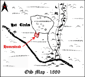
The important statement above is, ‘to guide about and shut in at night’ because as the lands of Buckfast Abbey bounded onto those of the royal Forest of Dartmoor it was a prerequisite that all stock would only have been allowed in the Forest by day. This meant that unless the monks wanted to pay a fine, all of their animals had to be driven out of the Forest every night and penned up until the following day, hence the need for an above mentioned enclosure. In this light the monks had two options, either they could walk the nine odd mile round trip from the abbey each day or establish a mansionis or homestead on the moor in which they could live, thus saving a lot of time and effort. Therefore, considering how efficient the Cistercians were, is it not surprising that they opted for the latter option? Not only could the stock be penned at night but also a guard against predators could also be mounted 24/7 which considering their value at the time was a prudent measure. So, the various historical documents gives a timeline of the homestead which stretches somewhere between 1190 (the charter of Richard I) and 1348/9 (the year of the first plague). They also provide a name of Henry Wallbrook as being the last lay brother from Buckfast Abbey to use the homestead. The historical trail then goes cold with very little information with regards to the old homestead, it does, although not specifically named, appear on the OS map of 1889 as can be seen below:
The Avon Reservoir was constructed between 1954 – 1957 and after that time the homestead became consigned to the murky waters of the river Avon. However, the story does not end here, luckily Aileen Fox carried out an archaeological excavation prior to the submergence of the homestead. This investigation revealed a lot more information about the site and in addition confirmed much of the historical evidence. The homestead consisted of a house, byre, yard and a pen or shed, all of which were constructed of granite boulders. Both house and byre had been levelled into hillside with their long axes parallel to the slope thus forming a typical medieval platform house. below this was a roughly rectangular paddock measuring 91 x 61ft, this was enclosed by a dry stone wall that contained a 4ft entrance on the eastern side. A plan of the homestead can be seen below:
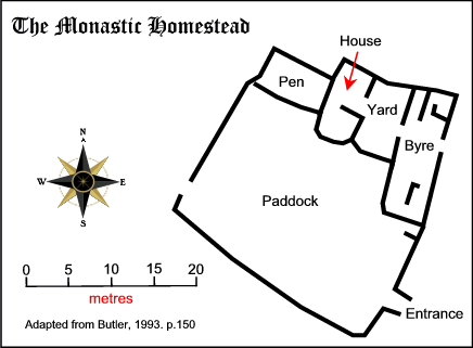
Butler, 1993, p.150
Entry to the house would have been from through the yard via a 4ft doorway that contained a timber frame and door. The interior of the dwelling measured 27ft x 12ft and would have been partitioned into two rooms. The lower one proved to be deep in dirt whilst the upper room presented a firm, clean floor with evidence of a fire having been lit by the western wall. It has been assumed that this room was used either as the sleeping quarters or a store room. The lower room also showed signs of a central hearth that was laid on some flat slabs, a drain was also present all of which suggest this was the kitchen. The roof would have been made of thatch which stood upon a ridge pole and rafters, large black chunks of charcoal would indicate that the thatch roof had caught fire. Analysis later proved that all the timbers were made from oak and the thatch consisted of reed stems or grass.
Of all the buildings the byre was the largest, measuring 49 x 14ft it had its upper end levelled into the hillside, the walls were constructed from huge slabs and boulders, probably robbed from the nearby prehistoric enclosure wall. The byre had two opposite entrances which virtually lined up with the doorway to the house, both measuring 3ft 6 ins. x 4ft 8 ins. The building was divided by the passage which lead from the two doorways, the upper section was divided into two compartments. The first measured 12ft x 4ft and was thought to have been a pony stall whilst the other was 6ft x 8ft and used as a cattle or sheep pen. The lower section was found to be much cleaner than the upper section and contained a small hearth near the western wall, in the south eastern corner was another pen measuring 11¾ x 4¼ft and may well have served as a lambing pen or calving box. The whole of the lower section was drained by a gentle slop that ran into a covered drain which ran down the centre and was lined with small pitched stones filled in with silt. This drain, along with the house and yard drains all ran under the respective southern walls. The outside yard was enclosed by drystone walls and measured 26 x 16½ft and contained a rubbish pit or midden in the south western corner. The excavation team came to the conclusion that originally the yard was only contained on three side, the lower wall being a later addition. Throughout the whole homestead the excavations revealed pottery sherds and whetstones, the acidic soil of Dartmoor has done a good job in degrading any bone that may have been on the site.
Having established that there was a homestead on the site, what does all the archaeological and historic data suggest? Basically, the archaeological information in the form of the pottery sherds suggest a period of occupation which ran from about 1250 – 1350, the end date tying in nicely with the historical documentary evidence of the 1348 – 1349 plague. The assemblage of pottery indicates that it all came from about 15 – 20 vessels amongst which were cooking pots, bowls and pitchers. In addition a small bung was discovered in the byre which has shown to have apple sediment on it, this means on those dark and lonely nights the lay brothers were holding cider parties – out of sight, out of mind. The whetstones clearly were used for sharpening tools of one kind or another, possibly sheep shears, knives etc.
The byre would have been ideally suited for animal husbandry and the existence of the hearth along with nearby potsherds would indicate a herdsman had at one time used the place, possibly at lambing or calving time. The house seems to have undergone two development phases, the first being simply that this structure was the only one standing. At this time the upper room was used for human occupation and the lower for animal occupation. Over time the byre, yard and paddock were added which meant all the livestock were transferred from the house thus the lower room became the kitchen. The investigation was unable to establish whether the homestead was permanently occupied or just used on a seasonal basis. In archaeology it is also possible to ascertain certain things from what is not found, in this case there were no spindle whorls or loom weights. As both of these were connected with weaving and that was women’s work it could be assumed that the homestead was a male only domain. Most of the charcoal found during excavation was analysed and was found to come from oak trees of which there would have been nearby supplies, one sample may possibly have been hawthorn, again easily found on the moor. This is the only known example of a medieval monastic homestead known on Dartmoor despite the southern moor being surrounded by early monasteries and abbeys.
Unfortunately I have never been to the site when the water level has been low enough to expose it but there are some photographs on the Dartmoor Archive website which can be found by searching for – Avon Reservoir, on such example can be found – HERE and HERE. In addition, the Google earth aerial photograph must have been taken in a fairly dry year because as can be seen below, some of the ruined walls are visible:
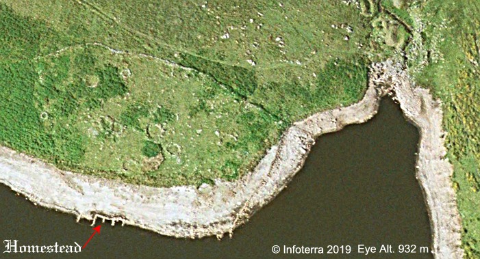
From the above image it’s clear how close the prehistoric pound was to the homestead and as noted above, how handy a source of building stone it proved to be. This being the exact fate of many of the Dartmoor’s prehistoric features down through the centuries, rather than cut and cart granite the builders simply robbed it from the walls of the structures.
Now I have this fascination with place-names and there is one in the area of the homestead that may or may not have a connection. Firstly, both Crossing, (1990, p.367) and Hemery, (1983, p.327) both mention that near to the homestead were three standing stones called ‘The Three Brothers’. Was this a possibly alluding to a monastic connection or simply just a coincidence? Either way they too are submerged under the waters of the reservoir. Another intriguing place-name is that of a small tributary of the river Avon which lies to the north west of the homestead. The OS map of today records it as the Western Walla Brook. Glover et al. (1992, p.16) notes how a 13th century document of Buckfast Abbey records the brook as Welebroc which they suggest comes from weille broc meaning ‘brook fed by the spring’. It is interesting to note that the last lay brother to live at the homestead was Henry Wallbrook in and around 1349. Whilst it is impossible for the brook’s name to have derived from him, did he take his name from the brook which in the perambulation of 1240 had mutated to Wester Wellabroke? Wellabroke – Wallbrook, again another coincidence?

Butler, J. 1993. Dartmoor Atlas of Antiquities – Vol. 4, Tiverton: Devon Books.
Crossing, W. 1990, Crossing’s Guide to Dartmoor, Newton Abbot: Peninsula Press.
Fogwill, E. G. 1954. Pastoralism on Dartmoor, In: Transactions of the Devonshire Association. Vol. 86 – pp.89 – 114.
Fox, A. 1958. A Monastic Homestead on Dean Moor, South Devon. In: Medieval Archaeology. Vol. 2 – pp.141 – 157.
Gover, J. E. B., Mawer, A. & Stenton, F. M. 1992. The Place Names of Devon. Nottingham: English Place-Name Society.
Hemery, E. 1983. High Dartmoor. London: Hale Publishing.