
Sat beside what is now a track leading to the China Clay workings is a lone solitary granite cross. The surrounding land is a palimpsest of prehistoric ritual and modern industrial landscapes of which the latter has sadly obliterated much of the former. The cross is actually marked on the OS map as ‘Blackaton Cross (restored) but it is also known as Roman’s Cross. Of the cross that stands today only the head and the base are original. Crossing notes how the shaft was donated by a Mr Phillips and it was initially cut for use as a window sill and then later donated for the restoration, this accounts for one of the corners showing evidence of bevelling. The actual dimensions of the cross are as follows; height – 1.87m, arm span – 64cm, circumference – 1.01m, and alignment – northwest/southeast.
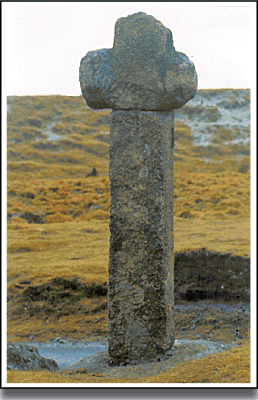
The OS map of 1889 clearly shows the cross marked as Blackaton Cross and it also suggests that somewhere on it is Bench Mark 929.7 but as far as I can see there is no sign of it today.
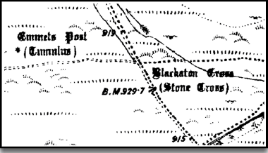
There are numerous explanations as to the various names that the cross goes under. First of all Crossing considers that ‘Blackaton’ refers to the nearby ‘Blackaton Slaggets’ which was once an area where peat was dug. Then as far as the Roman’s Cross he gives three explanations, firstly it is a local abbreviation for the Roman Catholic Cross, of which there are similar examples in the vicinity. Secondly he suggests that again it is a local corruption of ‘St. Rumon’s Cross’ as it stands near the route of an old track which led from Plympton Priory to Tavistock Abbey which was dedicated to St. Rumon. Finally it was thought that the ‘Roman’ referred to a nearby fort which was said to be of Roman origin. The OS map of 1889 clearly shows an ancient camp on the flank of Stewart’s Hill which is near to the cross.
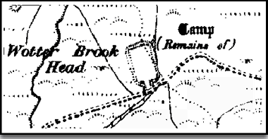
Samuel Rowe described the feature in his book of 1848 as being:
“… a parallelogram, measuring one hundred and fifty feet by eighty-six: the ramparts or artificial banks by which it is surrounded, are from twenty-six to forty-feet high in some places, and have been evidently constructed with sod and earth taken from the inside, and not from without, so as to form a fosse for more effectual defence, as is usually done. Since it could not have been an entrenchment for defence, the conjecture has been hazarded that this singular erection might have been for the purpose of exhibiting games, or for other large assemblies of people, but in all probability it is nothing more than a reservoir for water, of comparatively modern construction.”
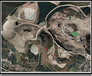
So here we have an initial suggestion of an amphitheatre of some kind ending up with the more likely explanation of some type of industrial feature. The red flag on the aerial map below shows the approximate location of the ‘Camp’ but as clearly shown it along with many other features have been lost under the hideous white waste mounds of the china clay works.
There has never been any archaeological or historic evidence to show the presence of Roman activity in the area which again would dismiss the Roman camp theory. There is also one final legend attached to the cross and that is it was erected to mark the spot where St. Paul once preached which seems highly unlikely.
Reading List.
Crossing, W. 1987 The Ancient Stone Crosses of Dartmoor, Devon Books, Exeter.
Harrison, B. 2001 Dartmoor Stone Crosses, Halsgrove, Tiverton.
Rowe, S. 1985 A Perambulation of Dartmoor, Devon Books, Exeter.
Sandles, T. 1997 A Pilgrimage to Dartmoor’s Crosses, Forest Publishing, Tiverton.
 Legendary Dartmoor The many aspects past and present of Dartmoor
