 Legendary Dartmoor The many aspects past and present of Dartmoor

:”They are formed by a number of small reaves, much overgrown, which intersect each other at right angles, and in the spaces thus formed there are a few hut circles. These also occur on the outside of the low walls.”, Crossing, 1990. p.330.
So speaks William Crossing about Foales Arrishes which is an unusually brief description for him, especially for such a feature. The Foales Arrishes place-name needs some explaining as it has no equine-based etymology as may be thought. Firstly, Mr. Foale was at one time an innkeeper of the nearby (now ruined) Newhouse Inn. Secondly, the word Arrish, is a Devonshire term for a stubble field the word deriving from the Old English word ersc, Clark Hall, p.107. .According to Eric Hemery (1983, p.662) Mr Foale grazed some of his livestock in this particular area hence, Foales Arrishes. However, this idea would be a deviation from the word arrish as there is no arable connotation. But as will be seen below, some earlier writers do suggest that these enclosures were also used for crop growing which would after harvest become stubble fields. It may well be that prior to inheriting this name the place was known either as Torr Town or Torr Hill, personally I think Torr Town is a far more evocative name. To apostrophe or not to apostrophe that is the question? throughout the various topographical tomes you will find that some writers include a apostrophe whilst others don’t and for the purposes of this page I won’t.
As with many of Dartmoor’s prehistoric sites, Foales Arrishes had the pleasure of playing host to the Dartmoor Exploration Committee in 1896. One of the initial remarks they made about Foales Arrishes was; “It probably received its modern name from some squatter who seems to have hazarded its cultivation, for attempts appear to have been made to gather the surface stones in heaps, so that a scanty tillage might be pursued between.”, TDA, 1987, p.151. Sabine Baring Gould also goes down the same defamatory line when he says: “The place bears the name of Foale’s Arrishes, from a man of that appellation who spent his energies in converting the prehistoric enclosures into fields for his own use, to the destruction of much that was interesting and to his own dubitable advantage.”, pp. 176 – 177.
One of the first things the committee noted was that the hut circles were in a dilapidated condition and at the time of their visit one of them was actually being dismantled by road builders for road mending. This was by no means the only Dartmoor monument that had suffered at the hands of the road builders/menders. At the time it was remarked that since 1851 Foales Arrishes had been the source of stone for road repairs which had completely removed all traces of the enclosure. The DEC report noted that; “Two hut circles have disappeared since the Ordnance Survey of 1885, and road menders were robbing the ancient track-lines at or about the time this exploration was in progress.”, TDA. p.151. The outcome of this was that the situation was reported to both the County and District Councils in the hope that their surveyors would put a stop to the activities of the despoilers.
As can be seen from the above details of the DEC’s ‘explorations’ they were very much focused on singular contexts whereas today a much wider view is taken to encompass the surrounding landscape. Therefore in this light the settlement could be described at least a three tiered palimpsest of land use and occupation. Foales Arrishes began life as the terminals of a series of parallel reaves on the level ground around Blackslade Water. Four of these features ran uphill past Pil and Top Tors and on towards Widecombe. Another set of reaves ran in the other direction and following the orientation over Rippon Tor and appear today as stone walls. These reaves belonged to the Rippon Tor system or territory described by Andrew Fleming which is one of the largest on the Eastern Moor. Butler suggests that what can be seen today is not the first settlement to have been established at Foales Arrishes. Traces of low banks can be seen, some of which were later utilised in newer walls.
Then the later hut circles were built along with some cross banks between the reaves thus encompassing the huts with rectangular fields. Shorter curved banks were then constructed outside these banks to give each dwelling a small paddock or yard. As time went on and the population expanded there was need for more dwellings etc, this resulted in a growth shift uphill as more fields were created, Butler, pp. 57 – 58.

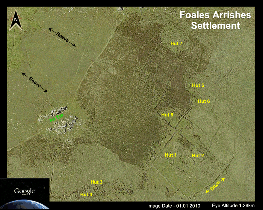
Aerial Landscape View |
Aerial Settlement View |
In more recent times the outer circuit wall was rebuilt by means of laying horizontal stones on top of the existing walls and an outer ditch dug. alongside them. This was probably the handiwork of the notorious Mr Foale of which enough has already been said.
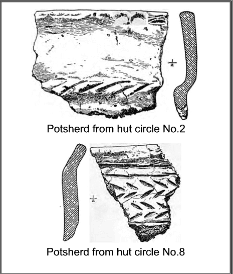
No recent excavation work has been carried out so the only site report is that compiled by the DEC in 1896. Luckily there were still some remains left for the committee to ‘explore’ which consisted of the eight huts that lie within the settlement of Foales Arrishes. In hut 1. (see plan below), the largest of the group they discovered it had an unusual annexe situated just outside the entrance. This was described as being; “a semilunar-shaped erection which contained a cooking hole and hearth, which much charcoal and some fragments of thin pottery. The whole of the floor was paved, forming a cooking place or kitchen outside the hut circle.” TDA pp.155. Butler is of the opinion that this kitchen was a later addition to the original hut building, p.58. Did one of the occupants get fed up of cooking smells in the dwelling quarters and decided to build a separate area for food preparation? Inside the hut the DEC also found a “curious feature”, in the form of, “a small stone standing 6 inches above the floor just inside the western side of the entrance, and two more standing side by side 15 inches above the floor near the north-western circumference.”, TDA P.152. These stones were set fast into the floor surface and stood about eight to inches proud, they consisted of thin slabs of granite. The DEC could offer no explanation as to their purpose but ruled out them being seat supports or parts of a stone platform. If you look at the hut plan it appears that these stones are in line with the entrance which could well mean that whatever they supported needed to be in a light source? The inside of the hut turned up a flint flake, possibly used as a cutting instrument, a flint flake, a fragment of blackened pottery and some charcoal. These finds would further endorse the idea of the cooking area being a later addition as all are indicative of cooking taking place inside the hut. They also uncovered a distinct potsherd. This was described as being similar to other pieces found at nearby Tunhill Rocks and Raddick Hill (some 16.5km away) all made of the same material and design. Their conclusion being that they (along with similar finds at nearby Tunhill rocks) were all proof, “that these pot-makers and users were probably contemporaneous and identical people“, TDA p.149. Today this would have been no startling revelation as trade routes stretching over far greater distances have been proven.
Hut 2 was built into the wall of a semicircular enclosure to which no obvious entrance can be seen today. Inside the hut they found a cooking hole along with flint fragments, some rubbing stones and some decorated pottery sherds possibly belonging to a cooking pot (see below). Baring Gould describes these potsherd finds as only he could; “The decoration is here and there made with a woman’s finger-nail. Consider that! Some poor barbaric squaw five thousand years ago fashioned the damp clay with her hands and devised a rude pattern, which she incised with her mails. She is long ago gone to dust and her dust dispersed, but the impress of her nails remains.”, p.177. I am sure that woman would be highly delighted, not, to be called a; “poor barbaric squaw.” This particular potsherd is a vital piece with regards to Dartmoor’s historical record because it has been identified as belonging to a style of pottery known as ‘Iron Age A’. Yeah, yeah, so what? Well as Gerrard notes: “The evidence of Iron Age occupation in the middle of the moor is both fragmentary and limited to a small number of sites. Only at the settlement sites of Kestor, Foale’s Arrishes, Fernworthy and Gold Park has excavated evidence been recovered.”, p.65. In addition to the actual age of these potsherds there is other important factor associated with them. In conjunction with earlier dated artefacts they would indicate that Foales Arrishes was in use throughout the Bronze Age down to the Early Iron Age, Petit, 1974, p.173. Very little was discovered in Hut 3 apart from a flint flake which is thought to have belonged to a knife of some sort. The excavation of Hut 4 was fruitless as no artefact were found or any signs of occupation which was the same in the case of Hut 5. Once again very little was discovered in Hut 6 apart from, what Butler calls, “a grit grubber”. Hut 7 proved to be more fruitful with definite signs of occupation. This dwelling was one of the later additions to the settlement and is located further up the slope than the rest. There were signs that the floor had been levelled into the slope and evidence of a fireplace along with two cooking holes were found. The artefact assemblage consisted of a flint scraper, flint flakes, pottery sherds, quantities of charcoal and a quartz crystal. Quartz crystal grave goods have been found in Bronze Age burial sites and clearly held some significance for the people of that era.
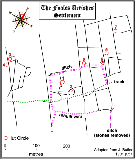
Plan of Settlement |
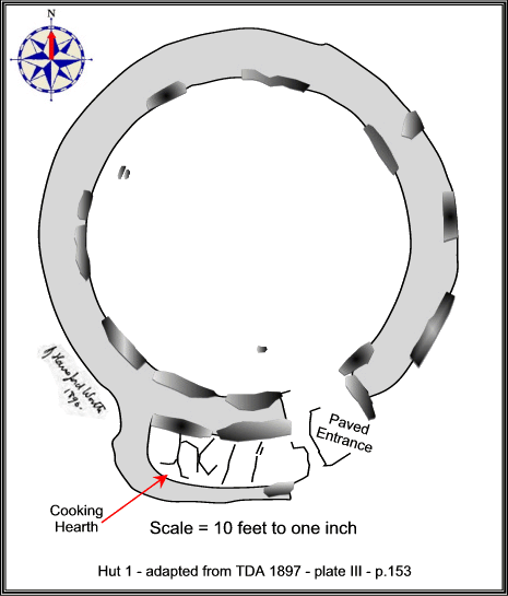
Plan of Hut 1 |
Potsherds |
In their report of 1897, the DEC made a very interesting observation that was based on their finding at Hut 1, I say interesting because this seems to be one of the earliest recorded suggestions of Bronze Age settlements being used for transhumance. They noted that:
“Considering the size of the hut circle – from 30 – 31 feet in diameter, involving a large roof, which would be difficult to keep weather-tight in the winter, whether thatched or made of skins – and the position of the main fire and cooking place, the Committee is of the opinion that this hut circle probably represents a summer habitation; and if this surmise be correct, it is an interesting illustration of the great antiquity of the summering of cattle on Dartmoor, for these huts and enclosures on the moor generally are the dwellings and paddocks of a primitive people, whose chief support was evidently obtained from their flocks and herds. Most of these examined so far, of much smaller dimensions, appear to have been permanent habitations; and this is the first instance which suggests to the Committee, on exploration, that some of the very large hut circles may have been resided in during the summer season only.”, TDA p.155.
The report also notes that prior to the road-menders pilfering the stonework, the enclosure at Foales Arrishes was. “almost as large as Grimspound.” Today it is pretty well accepted that Grimspound was at some point used as a ‘summer’ camp’ or ‘shieling’ during the periods of transhumance in the Bronze Age. English Heritage state:
“Shielings are seasonally occupied huts which were built to provide shelter for herdsmen who tended animals grazing summer pasture on upland or marshland. These huts reflect a system called transhumance, whereby stock was moved in spring from lowland pasture around the permanently occupied farms to communal upland grazing during the warmer summer months. Settlement patterns reflecting transhumance are known from the Bronze Age (c.2000-700 BC) onwards.”, – online source.
In 2012, some one hundred and fifteen years later than the DEC report, a book was published called; ‘Dartmoor’s Alluring Uplands’ and was based on the work of the late Harold Fox. In this book the practice of transhumance on Dartmoor is closely examined, albeit mainly concentrating from the Saxon period onwards. Here he demonstrates how in later periods some of these Bronze Age transhumance sites were still being used by herdsmen/women on Dartmoor.
As if poor old Foales Arrishes had not faced enough trials and tribulations there was and is one other little problem. In 1851 Croker commented that Torr Hill was difficult to find through the, “overgrowth of furze and heather.” Today the site appears on the English Heritage ‘Heritage At Risk Register’ with its condition being recorded as, “generally satisfactory but with significant local problems,” caused by, “plant growth‘ – see link opposite. Therefore I would suggest that the best time to visit the settlement is during the winter months when the bracken has died down. Whilst on the subject of visiting, as can be seen from the aerial landscape photo above, Blackslade Mire lies to the south of Foales Arrishes. It is advisable, especially in wet periods to approach from the north thus avoiding getting yourself all kaky!
As this website is called Legendary Dartmoor it would be remiss to leave Foales Arrishes without mentioning the legend attached to it. The story goes that sometime in the dim and distant past a local villager, presumably from nearby Widecombe in the Moor decided that he was going to set up home at Foales Arrishes. He must have been a determined man because despite all his neighbours pleas not to do so the man set off to the settlement. Apparently his idea was to build a shelter and live out his days in the peace and quiet of the moor. The poor fellow was last spotted leaving his village and that was the last anyone ever saw hide or hair of him. As to what fate befell him nobody exactly knows but there was/is the local tradition that the Devil himself frequents Foales Arrishes. Maybe he was taken away in a sulphurous cloud? Crossing p.330.


Baring Gould. S. 1982. A Book of Dartmoor. London: Wildwood House Ltd.
Butler, J. 1991 Dartmoor Atlas of Antiquities – Vol. 1. Exeter: Devon Books.
Clark Hall, J. R. 2004. A Concise Anglo-Saxon Dictionary. Canada: University of Toronto Press.
Crossing, W. 1990 Crossing’s Guide to Dartmoor. Newton Abbot: Peninsula Press.
Gerrard, S. 1997. Dartmoor. London: Batsford.
Hemery, E. 1983. High Dartmoor. London: Robert Hale.
Petit, P. 1974 Prehistoric Dartmoor. Newton Abbot: David & Charles.
Transaction s of the Devonshire Association. 1897. Fourth Report of the Dartmoor Exploration Committee – Vol. 29.
Thanks really interesting. I must go there next time I am in Devon