 Legendary Dartmoor The many aspects past and present of Dartmoor

Walk a short way up the tiny Grims Lake stream and you will arrive at a large area enclosed by a circular wall which immediately suggests a settlement of sorts. This is ‘Grimspound’, a very evocative name if ever there was one but unfortunately the place-name is only a few hundred years old. The person responsible for the naming and baptism of Grimspound was the Rev. Polwhele who was the first person to officially record its name in 1797. Latter antiquarians then got carried away somewhat and started to suggest entomological theories as to its origin. Spence Bate was probably one of the more fanciful of these men and his idea was that the actual settlement was built by the Vikings in order to provide a strong and secure place to keep their tin. To support this theory he refers to a dagger that had been recently discovered in a barrow on the ridge above the settlement, this was of a distinct ‘Scandinavian’ character or so he thought. The idea was further substantiated by a nearby tor called King tor and a barrow called King’s Barrow, the latter being the last resting place of a Viking chieftain called ‘King’ who gave his name to both tor and barrow. Roughly a mile away is an old tin mine called the Vitifer Mine, Spence Bate considered that the word ‘Vitifer’ was of Norse origin and meant ‘White Stream’ which would allude to the so-called ‘white’ tinge of the nearby stream caused by the china clay deposits it carries. Presumably this was the source of the Viking tin that needed to be securely secured at Grimspound, Page, 1895, pp. 209-10. Other theories of the sites usage have been a temple of the Druids, an Iron Age fort, a Roman town, a temple of the sun, a Phœnician settlement, a medieval tinners camp, a transhumance camp for shepherds, and a pound for stray cattle.However, a more recent idea was muted in the 1920s by the Abbot of Buckfast Abbey who considered that Grimspound was a monastic hermitage built in the 7th Century. This idea was enthusiastically taken on board by the famous Dartmoor authoress – Beatrice Chase. Not only did she think the hut circles at Grimspound were inhabited by monks but also every other hut circle on the Moor. This she considered was proof that Dartmoor was once populated by monks and Christians. She also surmised that the old ancient stone crosses that are dotted around the Moor was further proof. In summary she said; “I love to believe that our worshipful Dartmoor was once people by holy and peaceful hermits instead of by savages, and it is surely better for both visitors and residents to welcome this theory rather then to picture bloody and agonising human sacrifices in the places where we lightheartedly foregather for rest and renewed strength.
Everybody is entitled to their opinion and so firstly, Other Dartmoor occurrences of the ‘Grim’ element are the Grimslake, Grim’s Grave, whilst looking further afield there is Grims Dyke, Grimesthorpe, Grimsbury, Grimsby, and Grims Ditch. To be more specific, ‘Grim‘ comes from the old Norse word Grimr which was an alternative name for Odin. It also referred to a ‘masked’ person or one who conceals his name both of which Odin was renown for, Ekwall, 1980, p.205. The opinion of The Place-Name Society is that the ‘Grim‘ element is an Anglo Saxon word for the Devil and that this appendage was given to any old prehistoric site which they regarded as having diabolical associations, Gover et al, 1992, p. 482. This may well be that the Saxons adapted the word and substituted the Devil for Odin. However, if one consults Clark Hall’s venerable tome, he suggests that the Saxon word grimm means fierce or savage, (2004, p.160) so could the place name refer to the ‘settlement of the savage tribe’?
The ‘pound‘ element refers on Dartmoor to any walled enclosure of multiperiod origins, the prehistoric ones tend to be circular(ish) and surround settlements or animal enclosures. The historic examples were used for animal folds, manorial pounds, or drift pounds. Therefore in a nutshell we end up with a place-name meaning of the ‘walled enclosure of the Devil’ – every thing has its place and every place its name.
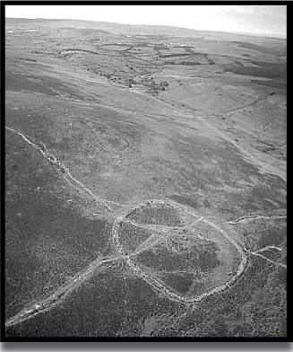
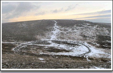
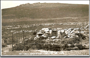
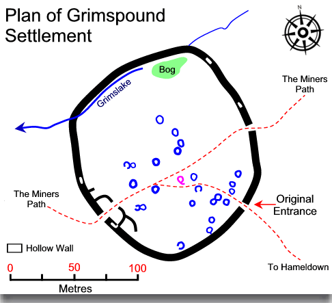
Grimspound was built in the Bronze Age, the current owners, English Heritage suggest that it was the LBA (Late Bronze Age), Chapman considers it to be of MBA (Middle Bronze Age) origin, several other noted prehistorians simply say it is Bronze Age. The actual site covers 4 acres (16,187 m²) and consists of 24 hut circles enclosed within a stone wall which sits nestled in a small valley at an altitude of 1,477ft (450m). As with any large site the best place to view the entire settlement is from the air, failing that on Hookner tor which lies to the north west. Below is an aerial photograph and below that is the view overlooking from Hookner tor, both pictures clearly show the two tracks which intersect through the pound and the associated erosion.
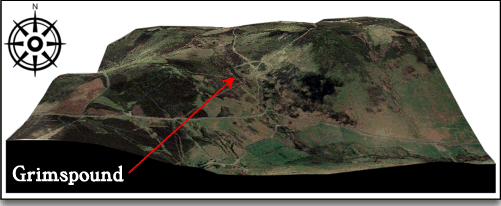
There has been a great deal of speculation as to the settlement’s purpose, one of which was that of a defensive nature. This theory has been reached by the size and thickness of the enclosure wall, this being by far the largest and strongest pound wall on Dartmoor. Ignoring the sturdy construction of the wall, in order for a site to be defendable it firstly needs to be in a location that would cause difficulties for any attackers, such as a hilltop. It should have a good view of the surrounding landscape in order to see any impending threat and ideally there should be a water source. There is no disputing the fact that Grimspound has a convenient water supply as the Grims Lake flows right through the enclosure. However the 3D map below clearly demonstrates that the settlement is situated in a small valley with no views of the northern, western, and eastern approaches. From a defensive point of view, once again its situation would lead it open to attack from above on both its western and eastern flanks. This would suggest that either it was not designed to be a defensive settlement or that the people who lived there considered themselves to be under no threat of attack. Personally I favour the former suggestion.
The other plausible theory was that it was the settlement of a cattle herding community and may possibly have been used during periods of transhumance. In order to shed some light on the question an early excavation was carried out during the period from 1894 – 96 by the Dartmoor Exploration Committee. Sadly, not only did they excavate the site they restored at least one of the huts (the mauve hut on the plan below known as No.3) and part of the enclosure wall. Therefore it is likely that the restoration work took on a modern interpretation of what the original building looked like.
Ironically, once the investigation was over the ‘restored’ hut had some iron railings placed around to protect it from being damaged by the moorland cattle, the modern equivalent of what the pound was first constructed to protect. The old postcard below shows the iron railings in-situ around the hut which judging by the amount of vegetation was taken around the 1930’s?
As mentioned above, the early excavation identified 24 huts located inside the enclosure wall, 13 of which showed no signs of occupation and were regarded as stores or animal pens, the majority of which were located near to the original entrance, the only other hut showing no sign of habitation is the most northerly. Of the huts that were dwellings, all are of a circular form with an entrance defined by door jams and lintels. The entrances were paved with naturally formed flat slabs, some had ‘porches’ which would have afforded some protection from the elements as they curved away from the doorway.
The early excavations determined which huts where occupied by whether or not there was evidence of a hearth. In all cases of occupied huts the hearths were either in the centre of the floor or opposite the doorway. Examination of ash found in the old hearths showed that the dwellers were burning small ash, oak, and willow sticks and peat. Near to the hearths was evidence of shallow pits probably used for cooking and heating water which was achieved by dropping heated stones into the liquid. There was very little evidence of fire-marked stones which could indicate that granite was used which would shatter after being heated and dropped into cold water. The other feature of the huts was the presence of a raised platform or dais, these were located to the right of the doorway. The raised platforms were built of stone and it is thought they would have been covered by animal skins, bracken or heather to provide a bed.
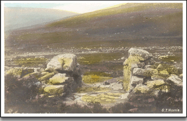
When the excavation committee turned their attentions to the enclosure wall it was discovered that the wall was originally hollow. It consisted of two separate walls, one inside thus creating a gap of about (1m) wide. These walls were supported by occasional cross beams made from granite slabs. It would have been possible to gain entry to the tiny internal passage by at least two openings, one of which can still be seen near the western entrance. It has been estimated that the original width of the wall would have been around 3.7m with a height of around 1.7m. Once again the committee carried out some restoration work on the wall, most of which occurred on the north-western side. The original entrance to the pound is that on the south eastern side of the wall. This was found to have been paved with three steps leading down into the enclosure. Chapman, 1996, p.8, suggests that the original building work would have been carried out by teams of builders, this is demonstrated by the two distinct building styles that can be seen on both sides of the entrance. However, this could simply be because, as Butler, 1991, p. 145, points out, this was where the excavators placed the clearance stones from their work on the entrance. The early postcard below shows the entrance and once again it is interesting to note the amount of vegetation growing at the front.
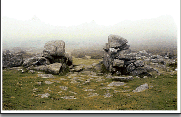
For comparison the photo below is a modern one but as is evident, very little has changed apart from the loss of the heather. One can also see the so-called different wall building styles or more likely the spoil stack from the early excavation.
The actual track that bisects the pound through the south-western and north-eastern walls was a later feature and is in fact the old path which leads from Manaton to the West Webburn tin mines. This is known locally as the ‘Miner’s Path’ and is said to date from the 13th or 14th centuries. Clearly those that trod the path were no respecters of antiquity as the track literally breached both walls in a straight line.
Another small feature that has been added to the pound is a small inscribed cross which can be found on the middle slab of the northern pillar of the original entrance. There has been little mention of the cross until recent years so probably it is the product of a bored moment and somebody with a sharp knife. It seems very unlikely that it is that old as any travellers on the miners path would not have passed through this entrance but maybe it was carved by some superstitious person who wanted to ward of the diabolical deeds of the Devil – who knows?
During the excavations very few day to day objects were discovered this will have been due the the acidity of the peat which would rot away any such finds. There were a few pottery sherds and flint fragments found and a barbed and tanged arrowhead has been found in latter years – but little else. As this property is know in the hands of English Heritage it would be nice to see some further archaeological investigation. Possibly pollen analysis and phosphate tests would show whether the settlement was involved in extensive cattle herding and production. Either way there is a lot of work still to be done on this site before it can be fully understood.
Amazingly, with such an ancient and notable site there are, to the best of my knowledge, no myths or legends associated with Grimspound. But one word of warning, if you wish to visit Grimspound, be sure of a fine day as a lot of the time it can be enveloped in mist. Do not make the mistake of thinking just because it is partially clear on the lower moor it will be so at Grimspound. Maybe this is why it is called Grimspound, the weather is nearly always ‘grim’?
Reading List.
Butler, J. 1991 Dartmoor Atlas of Antiquities, Vol. I, Devon Books, Exeter.
Chapman, L. 1996 Grimspound & Hound Tor, Orchard Publications, Newton Abbot.
Clark Hall, J. R. 2004. A Concise Anglo-Saxon Dictionary, Canada: Cambridge University Press.
Ekwall, E. 1980 The Oxford Dictionary of Place-names, Oxford University Press, Oxford.
Gover, J.E.B., Mawer, A., & Stenton, F. M. 1992 The Place-Names of Devon, The English Place Name Society, Nottingham.
Hemery, E. 1983, High Dartmoor, Hale Publishing, London.
Page, J. Ll. W. 1895 An Exploration of Dartmoor, Seeley & Co, London.
For your interest, there is a song done by damh the bard, titled Grimspound. This is the reason I found you!
Hi Tim,
Would you like me to provide you with some content on the geophysical survey I did here, and the results of it?
It was the first large scale geophysical survey of Grimspound.
Hope you are doing well!
Many thanks,
Jowan