 Legendary Dartmoor The many aspects past and present of Dartmoor

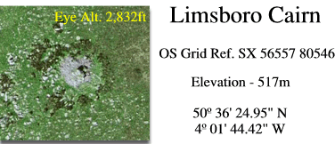
Just south of Lynch Tor stands a chaotic pile of granite which consists of an outcrop studded and encircled by smaller rocks and boulders, this is Limsboro Cairn. What at first appears to be an insignificant scatter of granite has in fact millennia of history lying back in the annals of time. If you consult the folks from English Heritage they will tell you that this feature is classified as a ‘Tor Cairn‘, the definition being: ‘a circular bank of stones and turf, sometimes accompanied by a ditch, surrounding a natural outcrop of rock, usually a tor, or an earthfast boulder.’. Sadly, through lack of archaeological investigation very little is known about tor cairns but English Heritage suggest: ‘The function and purpose of tor cairns is not precisely known, although it may be concluded that some sort of significance or power was attached or attributed to the natural formations at the focus of each monument. Thus they may be considered as ceremonial sites which date to the early and middle Bronze Age.’, (English Heritage, 2009, on-line source). These features tend to be located on on or near a hilltop, on elevated ground, or on a local eminence Most tor cairns are isolated examples, although on Dartmoor there are a few pairs known, as at Cox Tor where the sites are about 300m apart.
Tor cairns can be considered as an archaeological feature that tends to mainly occur in south west England, there are other examples on Dartmoor (ie Cox Tor) as well as Bodmin Moor. It has been estimated that there are between 30 and 40 recognised examples of tor cairns in south west England so we are not really talking about a common archaeological feature. In the scheme of things Limsboro tor cairn can be considered to be one of the smaller examples of its kind when the whole of the south west is taken into consideration. In this case, it is thought that the natural outcrop stood at around 3.5m high and was then, in the Bronze Age, surrounded by stones giving the monument a diameter of roughly 22.5m. Various field investigations have reported that some kind of ‘restoration’ has occurred which has resulted in the height of the cairn reaching a further 1.7m above the natural outcrop. Today Limsboro Cairn is said to be 23.5m (north – south) by 22m with various additions of drystone shelters possibly constructed by military personnel. Both William Crossing (1900, p.170) and Eric Hemery (1983, p.1018) both make mention of a small shelter built close to the cairn, Crossing actually states that it was a herdsman’s shelter, it would be a fair bet to assume that the stones used to build this came from the cairn. However, that is not to say that Limsboro is not a prominent feature in the modern landscape, it can actually be seen from an altitude of 7.5 miles away.
So, after its construction Limsboro Cairn lies concealed in the realms of oblivion until a party of knights happened past in 1240 when they decided it would be an ideal bond for the bounds of the Forest of Dartmoor. In this perambulation the following was recorded: ‘et inde usque as Lullingesfote‘ or in other words ‘and thence to Lullingesfote‘, (Brewer, 2002, p.37). In 1608 another perambulation was carried out and in this one Limsboro was recorded as Luntesborowe which is taken to mean the ‘tumulus of a man named Lunt’, (Glover, et al. 1992, p.195). I can go along with the ‘tumulus‘ theory insomuch as on Dartmoor the word borough often refers to a barrow or tumulus, but the ‘man named Lunt‘ bit doesn’t seem to fit. For some reason the English Place Name Society note that the Lullingesfote of 1280 is applicable to Lynch Tor which stands some 300m north west of Limsboro. The toponym Lullingesfote is said to have derived from the name of a hill, that being Lulling and so why cannot the Lunt element from 1608 be a corruption of Lulling thus giving ‘Lulling Hill Tumulus’? Just to confuse things even more, you can also throw the place-names of Limesboro (Crossing, p.157) and Linsboro (Hemery, p.1018) into the pot for good measure when referring to Limsboro. The parish of Peter Tavy has also decided to use Limsboro Cairn as a point on their boundary for several hundred years, again probably due to its prominence.
As a landscape feature it is very possible that in times of poor visibility Limsboro was used as a guide by those following the ancient Lych Way across to Lydford. About 800m south west of the cairn is the point where the old track starts its descent to Bagga Tor so it would be a good guide-point to head for when coming across from Cocks Hill. Getting of the point slightly, in view of this fact is it not questionable that the etymology of Lynch Tor has been assigned on the false theory that it, not Limsboro, was the Forest Bound. Would it not be more plausible to suggest that Lynch Tor has derived from Lych Tor in view of the fact that the ‘Lych Way’ passes nearby?
Sadly, once again due its prominence, Limsboro Cairn has suffered at the hands of the military who considered its location to be an ideal spot to plant a flag pole, as can be seen from the photograph below:
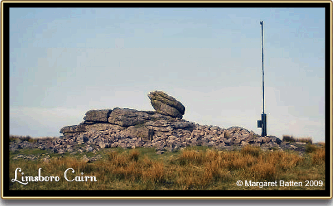
Two days ago the old military road was closed because it was felt that vehicles using it were detracting from the tranquillity and dark night skies of the moor. This notion was put forward by the Duchy of Cornwall with agreement from the clowns at the Dartmoor National Park Authority along with The Dartmoor Society and The Dartmoor Preservation Society. Now, what looks more offensive, a car driving slowly along a track or the abomination of a flag pole planted next to an archaeological feature such as Limsboro Cairn, I know what my answer is! Talking of Dartmoor’s tranquillity, try sitting next to such a flag pole on a windy day and see how tranquil the sound of the flag rope is as it clanks against the metal pole, yeah right!

Brewer, D. 2002.Dartmoor Boundary Markers, Tiverton: Halsgrove Publishing.
Crossing, W. 1990 Crossing’s Guide to Dartmoor, Newton Abbot: Peninsula Press.
English Heritage. 2009. Tor Cairns – Definition, On-line Source – HERE
Gover, J. E. B., Mawer, A. & Stenton, F. M. 1992. The Place Names of Devon. Nottingham: English Place-Name Society.
Hemery, E. 1983. High Dartmoor, London Hale Publishing.