 Legendary Dartmoor The many aspects past and present of Dartmoor

“Proceed over the common to Three Barrow Torr; a lofty elevation, so named from three huge barrows, or karns, on its summit – supposed, from their vast size to mark the tomb of some eminent warrior.” – 1827.
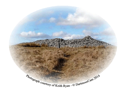
For once it is easy to see how this hill acquired its name of Three Barrows Tor, simply because on it’s crest sits three prehistoric cairns. On Benjamin Donn’s map of 1765 merely notes two places on the southern moor – Peter Cross Tor and ‘Threeburrow Tor‘. Today the Ordnance Survey maps have decided to drop the ‘Tor’ element and simply refer to the place as Three Barrows. If you would like the old local name for the hill then in the Devonshire dialect it was known as ‘Dree Berries‘. The highest point of the hill sits at a lofty 461 metres and along with the cairns has a trig point (OSGB36 Station No. PP209) for company. There can be no question that during the Bronze Age the whole area surrounding the hill was a busy place. There is virtually every type of ritual monument, settlement, dwelling, and boundary within a two kilometre radius of Three Barrows. In fact if one would like to go back even further there are the remains of a Neolithic long barrow about 2 kilometres to the south-east.
So as the name suggests there are three cairns on the hill which are labelled A, B, and C on the location map opposite. Cairn A is by far the largest of the three and measures 45 metres on a NWS alignment by 38 metres on a SWN alignment and stands at about 2.5 metres high, this is the largest cairn on Dartmoor. Over the years people have added there own interpretations in the form of additional walker’s cairns and shelters. Cairn B sits slightly to the NNW of cairn A and is slightly smaller having a diameter of 22 metres and standing at a height of 1.4 metres. Again this one has been greatly spoilt in later years. Also adding to its destruction was the ‘investigation’ carried out in 1872 by Spence Bate which in the end proved fruitless. In 1872 Spence Bate commented on his excavation; “This was done in company with Capt. Oliver with the assistance of several men belonging to his brigade of the Royal Artillery. We pursued our researches for three days, removing at least half the cairn, and excavated into the soil below, but without being rewarded for our labour.”, TDA. 1852, p. 553.
Cairn C is the most southerly of the trio and is virtually the same size as cairn B with a diameter of 22 metres and a height of 1.5 metres. Once again it has been badly mutilated by the addition of later pits and shelters.
About 440 metres to the NNE of the three cairns is a Bronze Age barrow along with its surrounding kerb circle. What is the difference between a barrow and a cairn? Basically in most cases cairns are constructed primarily from stone whereas barrows can be constructed from earth, turf, stones, timber or a combination of any of these. All around the cairns are numerous extraction pits which are thought to have been where the builders of the Red Lake tramway got their ballast from.
The other feature on Three Barrows Tor is the reave that runs on a north – south alignment with Barrow A and was anciently documented in the 16th century as “a long conger of stones called Le Rowe Rew.”, Crossing, 1990, p. 378. It is pretty clear that due to its course the reave was constructed after the building of the cairn as it takes a dog-leg to avoid the structure. In 1895 J. W. Ll. Page makes this interesting observation:
“In another ten minutes we are on the top of the immense cairn, which, supported on either hand by two smaller ones, crowns the hill of Three Barrows. This central cairn stands in the midst of a wide trackway, extending for more than a mile over the crest of the eminence. To say that all three cairns stand in the trackway is inaccurate… This British road, if such it were, is roughly paved with pieces of granite, and is, perhaps the finest specimen upon the moor.”, p.254.
Here is a prime example of the early antiquarian theory that reaves were trackways or as he calls them ‘British Roads’.
During Spence Bates’ excavation of cairn B in 1872 he came across an arm and the top of a shaft belonging to an old granite cross. Crossing considers that this was one of four crosses erected in 1557 when Sir Thomas Dennys and his team were surveying the bounds of Brent Moor, p. 378. The cross fragments were reported as being missing in 1871 but then possibly reappeared in 1937 lying on the highest cairn at Butterdon Hill. Starkey then comments; “The mutilated head of the cross turns up among the mass of boulders on the hilltop from time to time. Its last recorded appearance was in 1957. I have searched for but never have succeeded in finding it.“, p.22.
Being such a visible landmark feature it is not surprising that since time immemorial it has been used as a boundary marker. It is quite possible that during the Bronze Age cairn A was used to delineate some boundary as suggested by the Le Row Rew reave. Then possibly in the fourth century a document laying out the bounds of Buckfast Abbey on Brent Moor recorded ‘Triberie‘ as being one of the marker points, Brewer, p.133. Then again as noted above the hill was used in 1557 to serve as a point on the Brent Moor bounds.
Three Barrows was also the site of a tragic plane crash on the 1st of March 1944 when all four crew of a RAF Wellington bomber were killed. The aircraft was flying in low cloud from RAF Hurn in Dorset and was on route to Morocco when it drifted off course and flew into the hillside. Today there is a visible scar left by the crashed aircraft near to the largest of the three cairns, Wotherspoon et. al. p.30.
Some may think that the climb up to Three Barrows would provide little reward, after all there are only three badly mutilated cairns to see. But when undertaken on a clear day the views stretching across the South Hams, the South Devon Coast and northwards towards Cut Hill more than makes the effort worthwhile.

Brewer, D. 2002. Dartmoor Boundary Markers. Tiverton: Halsgrove Publishing.
Crossing, W. 1990. Crossing’s Guide to Dartmoor. Newton Abbot: Peninsula Press.
Page, J. Ll. W. 1895. An Exploration of Dartmoor and Its Antiquities. London: Seeley & Co.
Spence Bate, C. 1872. Researches into Some Ancient Tumuli on Dartmoor. Transactions Devonshire Association – Vol. V.
Starkey, F. H. 1989. Dartmoor Crosses and Some Ancient Tracks. Exeter: F. H. Starkey.
Wotherspoon, N., Clarke, A. & Sheldon, N. 2008. Aircraft Wrecks – The Walker’s Guide. Barnsley: Pen & Sword Ltd.
One comment
Pingback: Erme Plains, Magical Wild Camping in Dartmoor – Eat Sleep Wild