 Legendary Dartmoor The many aspects past and present of Dartmoor

The Whit Moor or White Moor stone circle has to be one of the remoter of Dartmoor’s stone circles. It nestles on the southern end of Little Hound Tor from where it surveys far and wide. Dotted in and around the surrounding landscape are Bronze Age settlements, cairns, stone rows, kists, and another stone circle as can be seen from the map below:
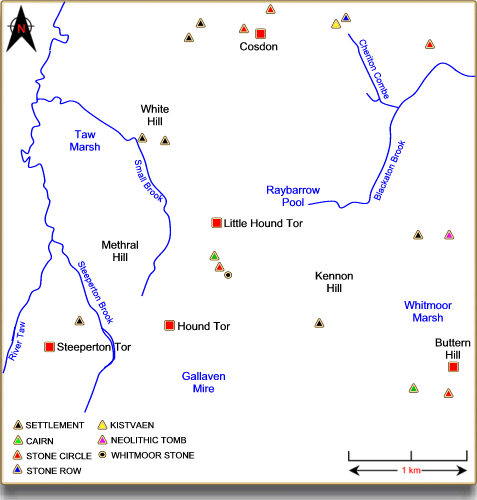
These however are not the earliest features as about 2 kilometres to the east lies what is thought to be a Neolithic tomb which predates any of the Bronze Age relics. The Whit Moor stone circle, like many other Dartmoor prehistoric remains, was in 1896 the subject of some restoration work by the Dartmoor Exploration Committee. Although they managed to resist the temptation to ‘explore’ the inside of the circle they did subject it to some ‘restoration’ work. This involved re-erecting five of the stones which over time had fallen down but to their credit still remain upright today. The modern ‘experience’ of the stone circle consists of 18 slabs, one of which is recumbent and another leaning perilously. It is possible that originally 19 stones made up the circle but the early examination by the D.E.C. found no evidence of a vacant socket hole. The stones of today range in size between 0.3m to 1.15m high and describe a circle of 20.2m across, (Butler, 1991, p.203). This would place the Whit Moor Stone circle 10th in the league of ‘who’s got the biggest diameter’ of the Dartmoor circles which sounds impressive except there are only 14 of them. But the tiny circle wins all hands down when it come to location altitude for at 437m it can claim to be the loftiest of them all. Associated with the stone circle is a cairn which lies about 90m to the south-south-east, this now vegetation covered mound measures around 8.5m across and shows signs of having been dug into at some point in history. View the ADS listing for the Whit Moor Stone Circle – HERE. In this north eastern sector of Dartmoor there is a cluster of 8 stone circles whose locations for a ‘sacred crescent‘ when plotted on the map and Scorhill sits in the middle of these.
There is one theory that folklore can provide which explains the stone circle and that goes way back to the time when the Sabbath was regarded as a sacred day. There are those who will have you believe that one such Sunday a huntsman was out with his dogs when suddenly there came a load clap of thunder and a bright blue bolt of lightening shot down from heaven. Upon hitting the moor the huntsman and his dogs were immediately turned to stone as a punishment for breaking the Sabbath. It is said that on dark nights you can hear the dogs baying for release from their stony tombs.
If you do a web search for the Whitmoor Stone circle you will find numerous entries on various ‘megalithic’ sites all bemoaning the fact of how hard it can be to get to. If you look at the above map you will see that to the north-east of the circle lies Raybarrow Pool, to the east is Whitemoor Marsh, to the south is Galleven Mire and to the north-west Taw Marsh. Pool, marsh and mire usually mean only one thing – wet feet at the best. One person actually complained that the, “footpath” on the OS map appeared to skirt Raybarrow Pool but actually the, “boggy area”, did not equate with the blue symbols on the OS map – oops, now there’s a thing, naughty, naughty OS. Personally speaking I would park on the ‘ring road’ follow the track down to Knack Ford then continue up the hill, head for Hound Tor and then cross to the circle – but that’s just me.
Well, ok, everything is straightforward, er, well actually about 150m to the south-east of the circle stands the Whit Moor Stone and as always on Dartmoor there is a debate regarding its origin. The stone has the letters ‘D C’, ‘T P’, ‘ST ‘ and ‘T’ carved onto it. DC denotes the ‘Duchy of Cornwall’, TP stands for ‘Throwleigh Parish’. ST means ‘South Tawton’ and T simply ‘Tawton’, (Brewer, 2002, p.51). From this it can be determined that over the years the stone has been used as a boundary marker and from the South Tawton bounds Brewer (p.50) notes how the stone was also known as ‘Weekmon’s Stone’. The stone stands at a height of 1.6m and is especially prominent from the south, nothing too contentious here. If you visit the Archaeological Data Service website you will see that the Whitemoor Stone is recorded as being, “A standing stone of unknown date standing on the parish boundary between Lydford, South Tawton and Throwleigh”, and is dated as being, “post medieval” – see HERE. One look at the stone and its proximity to the circle would immediately put into question the post medieval date, it is clearly a menhir. Worth, (1988, p.266) whilst not directly giving his viewpoint succinctly describes the dilemma involving the Whit Moor Stone:
“… which raises the unfortunate question whether, in its present position, it has not always been a bound-stone; if so it may possibly have been stolen from the stone circle … On the other hand the presence of that circle is favourable to the contrary view, that the stone is in its origin prehistoric and has been adopted as a boundary by a later race“.
What is in question here is that is the Whit Moor Stone the possible missing upright from the nearby circle which had been removed and pressed into use as a boundary marker? William Crossing (1990, p.211) seems to favour the ‘theft’ theory when he says: “Though now serving as a boundary mark it may still be a genuine menhir, though it is at the same time, not at all unlikely that it originally belonged to the stone circle nearby“. Butler (p.204) is more decisive and considers that, “… it seems too large to have been stolen from the circle… The stone may have been an outlier contemporary with the circle, perhaps re-erected as it is no longer orientated towards it or the cairn“. Hemery (1983, p.794) follows along the same lines:
“I do not subscribe to the theory, held by some, that it is the missing stone from the circle, transplanted to serve as a bond-mark: there is no example known to me on Dartmoor of such a purposeful removal, and I think the Whit Moor Stone stands in its original position“.”
Gerrard (1997, p.63) when discussing dubious menhirs adds the Whit Moor Stone to this list when he tentatively remarks: “The White Moor Stone near a stone circle of the same name and the Hanging Stone on Lee Moor may be standing stones still in their original location although both have been re-used as boundary stones“. Paul Pettit (1974, p.146) is much more positive in his theory:
“The explorers of the circle found only one gap in it, and the missing stone had been dressed before removal, the chippings lying near the hole. White Moor stone is of undressed granite so there is no place in the circle from which it could have been taken. This appears to support its prehistoric origins as a standing stone associated with a circle.”
So, those are the opinions of what I would call past and present experts, the easiest way for deciding for yourself is to pay the stone a visit, just don’t go via Raybarrow Pool.
Bibliography.
Brewer, D. 2002 Dartmoor Boundary Markers, Halsgrove Publishing, Tiverton.
Butler, J. 1993 Dartmoor Atlas of Antiquities – Vol. II, Devon Books, Exeter.
Crossing, W. 1990 Crossing’s Guide to Dartmoor, Peninsula Press, Newton Abbot.
Gerrard, S. 1997 Dartmoor, Batsford, London
Hemery, E. 1983 High Dartmoor, Hale Publishing, London.
Petit, P. 1974 Prehistoric Dartmoor, David & Charles, Newton Abbot.
Worth, R. H. 1988 Worth’s Dartmoor, David & Charles, Newton Abbot.