 Legendary Dartmoor The many aspects past and present of Dartmoor

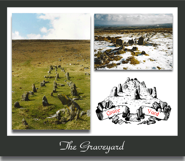
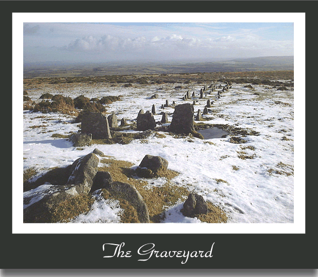
Silently reposing in the shadow of the great dome of Cosdon lies one of Dartmoor’s enigmatic prehistoric features which is locally known as ‘The Graveyard’ or ‘The Cemetery’. Hemery writes of this feature; ‘On the elevated plain is an impressive stone row, rare in being triple,… The monument is known on Dartmoor as ‘The Graveyard‘, (1983, p.797). Of this same monument William Crossing noted the following; ‘On the common on the east side of Cosdon is a monument known as The Cemetery, consisting of three rows of stones, starting from a double kist. Until a few years ago it was in a very ruinous condition, but a careful restoration has given it something of its old time appearance on the slopes‘, (1987, p.53). So before we even begin there is a slight difference of opinion, ‘The Cemetery’ or ‘The Graveyard’? In another of his publications Crossing informs us that the so-called restoration took place in 1897, (1990, p.213). However in 1896 Worth (p.712) stated that:
“The triple stone row on Cosdon Beacon, which was described by me for the first time in 1892 has this year been carefully examined by the Rev. S. Baring-Gould, and planned by Mr. R. Hansford Worth. As far as possible, missing stones have been replaced, and there is now, therefore, hope that this very interesting monument, which was greatly in danger from the operations of the surface quarrymen may be preserved”.
As the above was written in 1896 it seems that Crossing was one year out in his date for the restoration as the work had been done the previous year. This restoration was carried out by members of the Dartmoor Exploration Committee who at that time were carrying out similar projects on other prehistoric monuments. It is argued that many of these ‘restorations‘ were not very accurate (and in some cases downright fanciful) thus making it hard to establish today exactly what the original monument looked like. However, it can also be argued that if nothing at all had been done then it is possible that the entire monument may have been ‘recycled’ by the wall builders of the day as had happened to many of Dartmoor’s other lost monuments. In his report of 1896 Worth notes the following:
“Masons are now, and have been for years at work all over this portion of the Moor, breaking up large stones for wallers, or removing such as they deem suitable for gate-posts Three of the upright stones have been removed since 1894. Unhappily a large slice of common, consisting of many acres, has been recently enclosed and walled round. The wall is incomplete, and is still being worked at, and every available stone is taken for the construction“, (p.174).
It appears that the stone row was in dire threat of being dismantled and re-used for building the enclosure walls but to confound the situation was the existence of an old inter-moor track. This ran from South Zeal to Hangingstone hill and was used amongst other by peat cutters travelling to Hangingstone Hill and tin miners going to Bow Combe and Knack Mine, (Hemery 1986, p.208)This track actually cuts through the middle portion of the stone row and traces of this along with wheel runs can be seen today. Worth explains that this was an ancient track which over time had eroded away leaving a rough, stony and at times wet surface. Therefore those driving the peat carts tended to avoid the actual trackway and use the drier and firmer ground close to the stone row. Sadly cartwheels and standing stones don’t mix and in this case it resulted in many of the uprights breaking or being knocked down. Again Worth remarks that: “Only such stones as were insignificant – did not interfere with the cart-wheels – were left; and some of these are mere stumps, of which the tops have been wilfully knocked off, for the convenience of the carts“. aerial
When you see the various threats of the time it’s amazing that any of the stone row survived at all. Luckily it was realised that something needed to be done to protect the monument and once this had been accomplished the restoration could begin. Therefore, via the then-time vicar of South Tawton, an application was made to Charles Fursdon the manorial lord of South Zeal who owned the land. Fortunately he granted the request for action and issued a ‘protection order’ saying to all and sundry that the stones “should not be further molested“. Following this order the fallen stones were re-erected which not only had the effect of restoring the monument but also making it clear exactly which stones were not to be “molested” by human hand or peat cart.
The Graveyard |
The Graveyard |
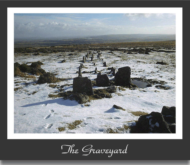
The Graveyard |

Aerial View |
This then leads us onto today and what exactly remains of the triple row thanks to the efforts of the Dartmoor Exploration Committee. The stone rows lie on an west – east alignment with a cairn at the western end and a large slab (possibly a fallen blocking stone) at the eastern end. The cairn sits at an altitude of 436m and the slab at 424m giving a 12m east to west incline of 12m and is located just north of the headwater of the Cheriton Combe brook. If the fallen slab was a blocking stone then the length of the rows is 176.5m, if not then the length reduces to 146m. As one travels along the stones in a westerly direction their heights increase from 1.3m to 1.6m. It can also be seen that the distance between the three rows remains fairly static along their length at 1.4m. At the lower western end it is noticeable that the stones on the northern row are taller than the other two and average out at 0.4m compared with 0.34m. It can also be seen that rows have a slight northerly curve of roughly 3° as the alignment progresses eastwards, (Butler, 1991, pp. 204 – 205). This according to Worth was; “due to the fact that in certain parts the rock rises so near the surface that it was not possible for the stone-planters to affix their blocks in the straight line without boring sockets in the rock; consequently they made a sweep to avoid these spots“.
The procession of stone rows symmetrically culminate the ruined cairn with the central row orientated towards its centre. In Dartmoor terms the cairn is out of the norm because it contains two kistvaens which share a communal end slab. Of the two kists one is virtually intact and still has its cover slab whereas the other has been robbed of two of its side slabs along with the cover stone. There are five stones in-situ which belonged to a retaining circle that once encircled the cairn, presumably the rest are lying in some nearby enclosure wall. Whilst restoring the monument the Dartmoor Exploration Committee took the opportunity to excavate both kists which showed evidence of being plundered at some point in the past by the despoilers. Whoever undertook such a pointless treasure hunt did for some reason replace the cover stone of the intact kist which I suppose does show a modicum of respect.
With regards to the original construction of the monument, Worth had an interesting theory:
“It was observable that the axis of one kistvaen and that of the second were not the same, and both somewhat different from the direction of the line of stones. It is probable that the first kistvaen was covered with stones and earth before the first line of stones was planted: consequently the stone-planters had nothing to guide them, except general direction. When the second kistvaen was constructed only the footstone of the first was exposed, and the stone chest was constructed, utilizing it; then covered, and the second line of stones planted parallel to the first. That the third line was in connection with a third interment is probable, but not substantiated by any evidence, owing to the mutilation of the monument“.
So basically what he was proposing was that the monument went through three phases of construction each related to a burial of some kind. If it could be proven that there were three internments in the kists this would mean that according to Worth’s hypothesis each one commanded a stone row for some reason or another? Sabine Baring-Gould also suggests that there were three kists inside the cairn, (1982, p.149) but this may well have been heavily influenced by Worth’s comments.
Despite various theories as to the intent and purpose of stone rows we are no nearer to reaching an answer than Worth was over a hundred years ago. Are they astronomically aligned, did they mark processional avenues, were they some kind of barrier or boundary or as Worth suggested did each one correspond with a burial? Could it have been that the stone rows were a ritual processional route and the two lanes made by the stones separated specific groups, ie. male and female?
Either way the construction of Dartmoor’s stone rows was varied and diverse but all seem to adhere to a basic concept of building. Phil Newman (2010, p.41) makes a good observation by suggesting that whatever their purpose; “the individual groups or communities who built them adapted the basic concept to suit their own requirements and the unique location and the materials available. Possibly the amount of available manpower may have influenced the size of the stones and complexity of the monument...”.

Baring Gould, S. 1982, A Book of Dartmoor, London: Methuen & Co.
Butler, J. 1991, Dartmoor Atlas of Antiquities – Vol. 2, Exeter: Devon Books.
Crossing, W. 1987, Stones of Dartmoor and Their Story, Brixham: Quay Publications.
Crossing, W. 1990, Crossing’s Guide to Dartmoor, Newton Abbot; Peninsula Press.
Hemery, E. 1986, Walking Dartmoor’s Ancient Tracks, London: Robert Hale.
Hemery, E. 1983, High Dartmoor, London: Robert Hale.
Newman, P. 2011, The Field Archaeology of Dartmoor, Swindon: English Heritage.
Worth, R. N. 1896, The Stone Rows of Dartmoor, Transactions of the Devonshire Association, Vol. XXVIII
I am interested in the mention of Bow Come mine, and it’s location. Or was Bow Come mentioned above the manor from which the tinners or peat workers might originate or from which they might once have been supervised (tinners) or permitted (peat workers?)
I know from my reading that it was said that there was once a medieval manor of that name, variously spelled, a portion of which in the mid-thirteenth century bordered upon Ugborough Church grounds, but which must have once been quite large, for it was divided later into upper and lower portions.
The manor of Holne was also large, but perhaps not as large, and bordered, at that time, the lands of Buckfasten and was donated to Buckfast Abbey in about 1257 in honor of a great knight of that era. Both manors, it seems, were managed by the Barons Valletorta but tenants were of the family of Stephen. (The Valletorta/Vautorte family had been originally barons under Robert Mortain, brother of William I, and are mentioned in Domesday as both overlords and underlords of various properties by the time of the survey. Yet, curiously, I have found almost no official genealogy related to that ancient family: perhaps it was and is forbidden to the heralds, for I find it quite odd that a family lasting for so many generations had so few noted marriageconnections with other Barons.)
Since the knight was named Stephen, I also wondered if the Dartmoor “Steven’s monument” might be connected? The location of “Steven’s monument” in relation to the “Bishop’s way” or ways thought to have been used by the monks of Buckfast, also would be of interest. The knight’s body was not, of course, buried on Dartmoor, but the monks or others might have put up a little monument in his honor all the same. I am finding hints that there were many honorific- names that might be related to this knight in Devonshire.
A relative, perhaps a brother, held Croyde and other properties. Another was a knight in religious orders. It seems another knight of that family “held Cheriton” in 1303. So the name of “Cheriton Brook” also seems connected: where was it? And where were these in relation to places named Zeal?. All of these connections, of course, cannot now be proven, but so many coincidences seem to point in that direction.. Perhaps I shall write like an old antiquarian and make suggestions as to possible connections? I do enjoy reading the old antiquarians, as they seem intent upon giving hints to things they have discovered but cannot say, and then covering their tails by running “d’rectly” off onto another direction, much like a rabbit in the chase.
These connections are becoming lost, the people living there having no idea of the history of their lands, because so much was nearly erased and certainly forbidden, following battles, uprisings and wars of religion and wars of the various contestors of the crown. Like the trees on Dartmoor, if the roots die, the tree blows over and is lost. But “the stones cry out.”
If you can answer my questions, or provide the best mapping that includes these monuments, I would appreciate it.
Originally Bow Combe was known as Chimney Bow and is basically where the tinners were streaming for tin as opposed to actually mining it and can be found at OS grid SX 618 877. Knack/Knock Mine, AKA Wheal Virgin can be found at OS grid SX 614 884.
Not sure what you mean by ‘Steven’s Monument’ the only similar thing I know of is ‘Stephen’s Grave’ which is a set stone supposedly marking the grave of a post medieval suicide and is located on Langstone Moor – SX 5362 7813. Both Stephen’s Grave and Knack Mine are marked on most modern OS maps but not Bow Combe. Hope this helps.
Yes it was Stevens Grave I meant. Thank you for the information!