 Legendary Dartmoor The many aspects past and present of Dartmoor

One of Dartmoor’s most enigmatic features are the standing stones which sit on the remote hilltops surveying the centuries as they speed by. The sad fact is that in the whole of the Dartmoor National park there are only 12 which are left intact and stand on the open moor. The total can be stretched to 15 if you include one that is built into the wall of a restaurant, the Maximajor Stone which is now a roadside menhir and another modern one that was erected in 1999. It does not seem possible that originally there were so few, especially when the vast number of other prehistoric remains are considered. Many probably have fallen prey to the wall builders, farmers, and stone cutters of old and have been shattered and dispersed like chaff in the wind. There still could be a few that have fallen down and are awaiting discovery by some eagle-eyed walker.
One could be forgiven for thinking that there is a degree of male chauvinism with regard to Dartmoor’s standing stones as there is a Beardown Man, Loughtor Man, Harbourne Man, and at one time possibly a Quinter’s Man. Nowhere will you find a ‘lady’ or ‘woman’ and before the ‘PC’ brigade start shuffling their feet this is because the ‘man’ is a local corruption of the Celtic word – ‘maen‘ which means, stone. The other place-name that often alludes to a standing stone is ‘Langstone’ this is another local corruption of the word ‘Longstone’. Finally, as mentioned many times in this site we have the ‘menhir’, this being from the Breton/Celtic maen hir which means ‘long stone’. Then there are the usual terms orthostat, megalith and monolith that are also used to describe the stones. So, man, langstone, menhir, standing stone, orthostat, monolith or megalith all refer to the same feature on Dartmoor, there are nearly as many different names as there are actual examples especially if you throw in the old moor term ‘pawst’ (post).
I have never seen anyone yet when coming across a menhir that has not resisted the urge to reach out and touch it. Is there some innate need deep within that recognises some ancient belief or re-assurance held in the stone? It is as if they are trying to reach back into the past to find some lost ancestral spirit or knowledge.
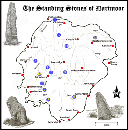
As mentioned above there are 12 menhirs standing on the open moor, (the numbers in brackets refer to the map below) these are:
| |
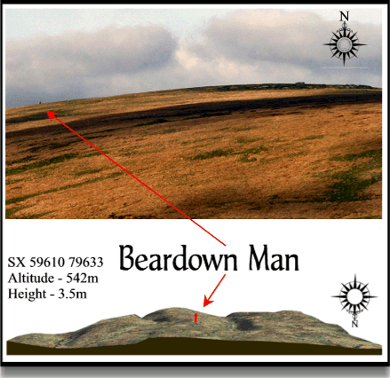
(1) Beardown Man – grid reference SX 59610 79633 |
| |
(2) Drizzlecombe (a) – grid reference SX 59060 66868 |
| |
(2) Drizzlecombe (b) – grid reference SX 59136 66990 |
| |
(2) Drizzlecombe (c) – grid reference SX 59210 67000 |
| |
(5) Hanging Stone, The – grid reference SX 58703 63703 |
| |
(6) Harbourne Man – grid reference SX 69648 65060 |
| |
(7) Hingston Hill – grid reference SX 58705 69275 |
| |
(8) Langstone Moor – grid reference SX 55025 78766 |
| |
(9) Loughtor Man – grid reference SX 65223 75386 |
| |
(10) Merrivale – grid reference SX 55360 74593 |
| |
(11) Shoveldon – grid reference SX 66023 85678 |
| |
(12) Whitmoor Stone, The – grid reference SX 63350 89476 |
Of all the above menhirs, the ones that truly ‘stand alone’ or are not associated with any other feature, the candidates are; Beardown Man, Harbourne Head and the Hanging Stone. Which when compared to the neighbouring county of Cornwall is very lacking in numbers and this cannot completely be put down to damage or loss. As an idea of what is meant by isolated menhirs the picture below shows an actual photograph and a topographical 3D map of the location of Beardown Man
The map below shows the locations of the Dartmoor Menhirs, if you click on the blue circle it will take you to a photo of each one.
So, how do the menhirs compare, insomuch as their heights? the table below shows the modern heights recorded in 1990. The important thing to remember is that some of them are ‘shrinking’ all the time or rather the peat in which they stand is growing. This has the effect of making the menhirs shorter as the peat level rises, measurements taken previous to the 1940’s clearly show that apart from Beardown Man all the rest have lost a few centimetres over the past 50 years.
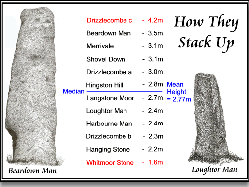
Menhir heights taken in 1990.
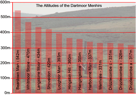
It is also an interesting exercise to look at the physical height of the moor in which each individual menhir stands. As can be seen from the chart below, Beardown man stands at the highest altitude at 542m whilst the Drizzlecombe (a) menhirs is sited at the lowest height which is 317m. The mean altitude of the Dartmoor menhirs is 384.6m
Having looked at the collective terms for Dartmoor menhirs, their names, locations, heights and altitudes it would be prudent to put a date on them. Menhirs are generally regarded as being a Bronze Age feature which means they were erected about 4,500 years ago although the only two that are regarded as definitely Bronze Age are Beardown Man and Harbourne Man.
Some of the menhirs have been re-used as boundary markers and have incised lettered cut into one or more of their faces, namely; Shoveldon and The Whitmoor Stone.
Of the examples located in ‘off the moor’ locations there is the ‘Maximajor Stone‘ or ‘Headless Cross’ which had later been used as an inscribed wayside cross and is now a replica (number 15 on the map). The ‘Touchstone‘ can be classified as a menhir but it was erected in 1999 so it certainly has not got pre-historic associations (number 13 on the map). Finally there is the menhir which is built into the wall of the restaurant at The Oxenham Arms. It is said that when the original building was being constructed the menhir was set too deep to remove and so the room was erected around the stone which completely encompassed it (number 14 on the map).
Finally we come to the question of ‘what were they used for’, and if anybody has the answer to that they should write a book and make a fortune. Suggestions include, territory markers, grave and cemetery markers, meeting places, way markers, and as a focus for ritual ceremony which is the archaeological term for “not really sure.” Personally I favour the ‘meeting place’ theory for those not associated with any other feature such as a stone circle, grave or row. If there was to be a gathering of ‘tribes’ for the purpose of exchange, social or religious activities then surely it would be held at the edge of the various territories as this would be a neutral place or kind of ‘no mans land’. This would be somewhere where the jurisdiction of differing tribal laws and beliefs became neutralised and thus no offence incurred. One of my ancestors was a bare knuckle fighter, which at the time was an illegal activity and he used to hold his matches at a boundary stone which marked the intersection of five parishes. This meant he was always on neutral ground as it did not come under one complete jurisdiction, which in a way is a similar theory. With regards to exchange, did not the idea of meeting at a singular spot later become to be represented by the ‘market cross’ where people gathered by a stone menhir with arms to buy and sell goods? Similarly did not the same happen with religious events at the ‘preaching’ cross where travelling preachers would assemble their congregations?
As far as folklore goes there is not a lot attached to the Dartmoor examples, they were held in some awe as to interfere with one was an invitation to bad luck. To dig one up was deemed very foolish and only misfortune would follow, this I think was mainly as the menhirs were set so deep it was nearly impossible to do so. In some instances they were thought to bring good luck as in one that stood on the fringes of western Dartmoor. This one evidentially had a cup like depression in the top which often filled with rainwater and the local farmers always believed that if their cattle were driven under the stone and the water dripped in their backs it would increase the milk yields.
Great information, inspired some great remote walks to visit some truely awe inspiring locations. Thank you